Download presentation
Presentation is loading. Please wait.

3
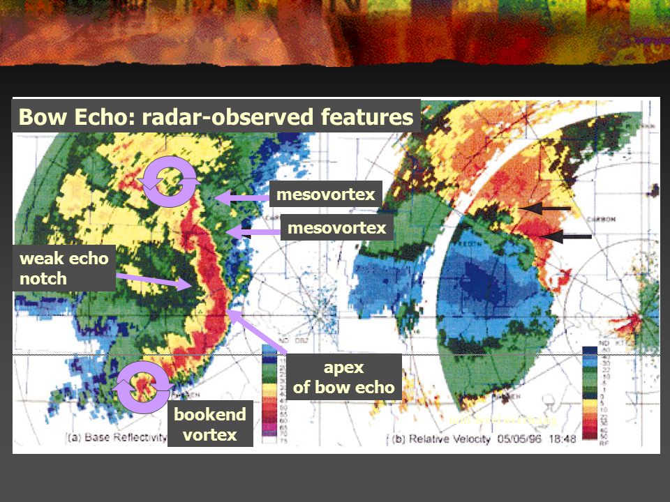
mesovortex apex of bow echo Bow Echo: radar-observed features mid-level overhang weak echo notch bookend vortex

4
1-4 August 2007 WMO Workshop on Radar Meteorology & Nowcasting 1-4 August 2007 WMO Workshop on Radar Meteorology & Nowcasting Front-to-Rear Flow Houze et al. (BAMS 1989) All flows are system-relative Ascending front-to-rear flow: Instrumental in creating stratiform rain shield Forced by a horizontal pressure gradient associated with mid-level mesolow in the stratiform rain area; mesolow marks the hydrostatic response to the net latent heat release by the convective cells
 All flows are system-relative Ascending front-to-rear flow: Instrumental in creating stratiform rain shield Forced by a horizontal pressure gradient associated with mid-level mesolow in the stratiform rain area; mesolow marks the hydrostatic response to the net latent heat release by the convective cells.")
5
1-4 August 2007 WMO Workshop on Radar Meteorology & Nowcasting 1-4 August 2007 WMO Workshop on Radar Meteorology & Nowcasting Phenomena associated with horizontal vorticity + - 1.Updraft2. Vertical Shear3. Cold Pool + + -

6
1-4 August 2007 WMO Workshop on Radar Meteorology & Nowcasting 1-4 August 2007 WMO Workshop on Radar Meteorology & Nowcasting Interactions of Vorticity Regions Matching vorticity regions of opposite sense Mismatched vorticity regions of opposite sense

7
1-4 August 2007 WMO Workshop on Radar Meteorology & Nowcasting 1-4 August 2007 WMO Workshop on Radar Meteorology & Nowcasting Life Cycle (a)Downshear tilt due to ambient shear (b)Balance of cold pool and low-level shear (c)Cold pool overwhelms low-level shear; formation of a rear inflow jet “RKW Theory” (Weisman and Rotunno; JAS 2004)
Downshear tilt due to ambient shear (b)Balance of cold pool and low-level shear (c)Cold pool overwhelms low-level shear; formation of a rear inflow jet RKW Theory (Weisman and Rotunno; JAS 2004)")
8
1-4 August 2007 WMO Workshop on Radar Meteorology & Nowcasting 1-4 August 2007 WMO Workshop on Radar Meteorology & Nowcasting Rear Inflow Jet Houze et al. (BAMS 1989) Rear Inflow Jet (RIJ): Generated by a vertical gradient in horizontal buoyancy contrasts The circulation associated with latent heat release aloft reinforces the cold pool circulation In other words, RIJ accelerates into mid-level L
 Rear Inflow Jet (RIJ): Generated by a vertical gradient in horizontal buoyancy contrasts The circulation associated with latent heat release aloft reinforces the cold pool circulation In other words, RIJ accelerates into mid-level L.")
9
1-4 August 2007 WMO Workshop on Radar Meteorology & Nowcasting 1-4 August 2007 WMO Workshop on Radar Meteorology & Nowcasting Houze et al. (BAMS 1989) Rear Inflow Jet (RIJ): RIJ descends towards the front of the squall line where as -- jet cools due to melting of ice -- rain falls into its dry air cooling it through evaporation RIJ helps maintain strong rising motion near the leading edge of the cold pool Rear Inflow Jet
 Rear Inflow Jet (RIJ): RIJ descends towards the front of the squall line where as -- jet cools due to melting of ice -- rain falls into its dry air cooling it through evaporation RIJ helps maintain strong rising motion near the leading edge of the cold pool Rear Inflow Jet.")
10
1-4 August 2007 WMO Workshop on Radar Meteorology & Nowcasting 1-4 August 2007 WMO Workshop on Radar Meteorology & Nowcasting Strong Squall Lines Strong environmental shear Gust Front stays close to precipitation Storm remains upright near deep gust front Strong environmental shear Gust Front stays close to precipitation Storm remains upright near deep gust front

11
1-4 August 2007 WMO Workshop on Radar Meteorology & Nowcasting 1-4 August 2007 WMO Workshop on Radar Meteorology & Nowcasting Vorticity Interaction: Cold Pool Lift + = 2.3: Matching cold pool + shear LFC Deep Lift shear counteracts the cold pool’s tendency to sweep environmental air over the top of the cold pool.

12
1-4 August 2007 WMO Workshop on Radar Meteorology & Nowcasting 1-4 August 2007 WMO Workshop on Radar Meteorology & Nowcasting Strong Squall Lines Storm-Relative Velocity shows gust front at leading edge of reflectivity core Gust front is also vertically-stacked and deep Storm-Relative Velocity shows gust front at leading edge of reflectivity core Gust front is also vertically-stacked and deep

13
1-4 August 2007 WMO Workshop on Radar Meteorology & Nowcasting 1-4 August 2007 WMO Workshop on Radar Meteorology & Nowcasting 20-200 km long curved line of cells usually associated with long swaths of damaging surface winds Develop some hours into MCS lifecycle + can persist for several hours Forms in environments similar to supercells (CAPE > 2000 J/kg; strong vertical shear of 30 kts+ over lowest 2.5-5 km) except for mechanisms promoting linear, rather than cellular, organisation (high T/Td spread etc.) Rear Inflow Jet associated with a pair of cyclonic and anti-cyclonic “bookend” vortices mid-level vortices (~ 3-7 km above ground), one at each ends of line primarily produced by tilting of horizontal vorticity at downdraft edge cyclonic poleward vortex usually becomes dominant over time due to Coriolis comma-shaped system appearance 20-200 km long curved line of cells usually associated with long swaths of damaging surface winds Develop some hours into MCS lifecycle + can persist for several hours Forms in environments similar to supercells (CAPE > 2000 J/kg; strong vertical shear of 30 kts+ over lowest 2.5-5 km) except for mechanisms promoting linear, rather than cellular, organisation (high T/Td spread etc.) Rear Inflow Jet associated with a pair of cyclonic and anti-cyclonic “bookend” vortices mid-level vortices (~ 3-7 km above ground), one at each ends of line primarily produced by tilting of horizontal vorticity at downdraft edge cyclonic poleward vortex usually becomes dominant over time due to Coriolis comma-shaped system appearance Bow Echoes
 except for mechanisms promoting linear, rather than cellular, organisation (high T/Td spread etc.) Rear Inflow Jet associated with a pair of cyclonic and anti-cyclonic bookend vortices mid-level vortices (~ 3-7 km above ground), one at each ends of line primarily produced by tilting of horizontal vorticity at downdraft edge cyclonic poleward vortex usually becomes dominant over time due to Coriolis comma-shaped system appearance km long curved line of cells usually associated with long swaths of damaging surface winds Develop some hours into MCS lifecycle + can persist for several hours Forms in environments similar to supercells (CAPE > 2000 J/kg; strong vertical shear of 30 kts+ over lowest km) except for mechanisms promoting linear, rather than cellular, organisation (high T/Td spread etc.) Rear Inflow Jet associated with a pair of cyclonic and anti-cyclonic bookend vortices mid-level vortices (~ 3-7 km above ground), one at each ends of line primarily produced by tilting of horizontal vorticity at downdraft edge cyclonic poleward vortex usually becomes dominant over time due to Coriolis comma-shaped system appearance Bow Echoes")
14
1-4 August 2007 WMO Workshop on Radar Meteorology & Nowcasting 1-4 August 2007 WMO Workshop on Radar Meteorology & Nowcasting Areas of particularly severe winds within bow echoes strong straight-line winds in apex of bow cyclonic bookend vortex on poleward end anticyclonic bookend vortex on equatorward end low-level mesovortices near or poleward of apex of any bowing segments

Similar presentations


 that may contain a stratiform rain region.>")

 Lemon, L. R., and C. A. Doswell III, 1979: Severe thunderstorm evolution and mesoscyclone structure as related to tornadogenesis.>")


 Region of low radar reflectivities on inflow side of storm o Near the surface High reflectivities.>")
 Weisman, M. L., 1992: The role of convectively generated rear- inflow jets in the evolution of long-lived mesoconvective systems. J. Atmos.>")


