Download presentation
Presentation is loading. Please wait.

1
Surges Through Gaps in Coastal Terrain Cliff Mass and Mike Warner University of Washington

2
The Phenomenon We are all familiar with the extensive literature on gap flow through level gaps. Generally, associated with ageostrophic flow, with the strongest winds near the exits of the gap. Surface winds in Columbia Gorge

3
The Phenomenon But there is another, related feature, apparent in such orographic gaps, in which very strong winds surge through the gap in response to passage of a synoptic scale trough. Tends to have both geostrophic and ageostrophic characteristics. Today I will give a prime example of this phenomenon: westerly wind surges through the Strait of Juan de Fuca.

4
The Region

5
Snohomish County Seattle

6
Westerly Wind Surges Are associated with powerful and damaging winds over the Strait of Juan de Fuca and immediately downwind…sometimes reaching 70-80 mph Usually associated with a mobile short wave trough moving in from the NW. Strong along-gap geostrophic wind and ageostrophic acceleration.

7
Background Scale analysis by Overland (1984) showed how winds in a gap can be geostrophic w.r.t. the cross gap pressure or height gradient, and ageostrophic with down gap pressure gradient.

8
H L H L isobar

9
Some Examples

10
December 17, 1990: The Elwha Surge Washington State Ferry Elwha

11
The Elwha Surge Over a period of a few hours, sustained winds of 50-70 mph with gusts to 70-80 mph, extended across Whidbey Island into Snohomish County, causing considerable tree falls and loss of power. By the end of the storm, nearly 141,000 Snohomish and Island county customers were in the dark and many roads were impassable. According to the Snohomish County Public Utility District (PUD), the 17 December event was the “worst in history from the standpoint of disruption, hardship, and dollar damage”, eclipsing the destruction of even the great Columbus Day Storm of 1962.
, the 17 December event was the worst in history from the standpoint of disruption, hardship, and dollar damage , eclipsing the destruction of even the great Columbus Day Storm of")
12
The event was so noteworthy the local utility district even published a newspaper about it.

13
The Elwha Surge Winds were particularly severe in Everett Harbor, where some ship anemometers measured 70-80 mph winds. The Washington State ferry Elwha was thrown against the pier by increasing wave action, destroying a wooden barrier and snapping off pilings. Subsequently, the ferry beat against a concrete pier until the vessel’s car deck crumbled.

14
December 17, 1990 Seattle Times and The Snohomish County Daily Herald

15
NCEP 500 hPa reanalysis at 06Z on Dec 18.

16
850 mb heights

17
Surface observation chart at 02Z on Dec 18 (during the hour of maximum winds). Smith Island is recording a 39 knot sustained wind. A pressure difference of 4.6 hPa occurred between the west entrance of the Strait and Smith Island.

18
October 28, 2003 – The Ivar’s Storm o Strong winds surged eastward through the Strait behind an upper trough and associated Pacific front, producing wind gusts exceeding 60 mph from Edmonds to Whidbey Island. o Nearly 100,000 people lost power o One death on Whidbey Island from a tree falling onto a parked car o Partial destruction of Ivar’s restaurant at Mukilteo Landing

19
October 28, 2003 Seattle Times

20
Ivar’s “rogue wave” mural

21
October 28, 2003 500 mb heights overlaying an infrared satellite image from 4 PM PST on Oct. 28. A high amplitude ridge extends into Alaska and a short wave trough over southwest British Columbia.

22
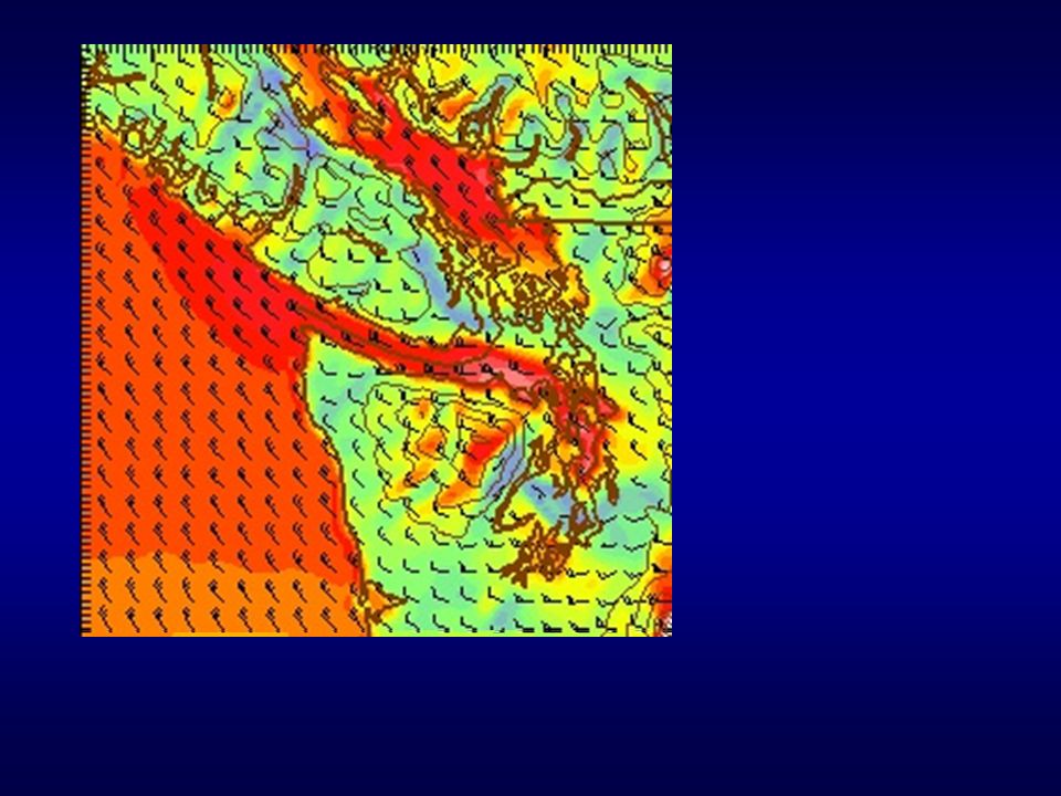
MM5 correctly forecast the winds. White (red) areas indicate sustained winds exceeding 46 (32) mph, gusts would be higher UW MM5 24-h forecast
 areas indicate sustained winds exceeding 46 (32) mph, gusts would be higher UW MM5 24-h forecast.")
23
Animations of MM5 Simulation Surface wind evolution Upper level Evolution Sea level pressure evolution

24
Side note: Ground Zero of Strait surges is Everett Harbor --the location of the new Navy carrier base for the West Coast!

25
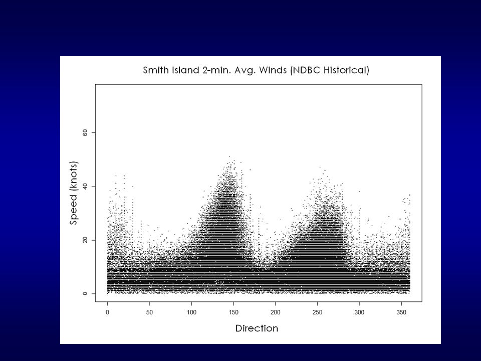
How Frequent Are Westerly Surges Through the Strait of Juan de Fuca? More specifically: How often do we observe surface winds exceeding 30 knots from a westerly direction (250 through 300°)?
 .")
26
Climatology of Strait Surge Events --More strong surges in winter --More weak events during summer Sustained Winds

27
Synoptic Composites of Strong Surges 25 events where at least two stations in eastern Strait recorded winds exceeding 40 MPH in a westerly direction

28
850 mb Height Composite

29
Sea Level Pressure Composites

30
Physical Mechanisms Most strong westerly surges occur as sharp trough moves through from the northwest. A large height gradient exists normal to the Strait, with strong northwesterly flow from 850 mb through 500 mb. After the trough passes the Olympics/Vancouver Island mountains, a pressure gradient forms along the Strait, with higher pressure offshore.

31
Mechanisms The lower inland pressure is both a reflection of the upper disturbance and lee troughing due to westerly flow impinging on the mountains.

32
Mechanisms Thus, there is an ageostrophic, downgradient wind acceleration down the Strait from the northwest at low levels. Geostrophic winds from aloft is from the same direction and strong…thus, supporting the surge. Temporally short…a few hours of maximum wind, since dependent on proper position of the synoptic trough.

33
45 mph or more ∆Z is the subjective height change normal to the Strait ∆p is the observed difference in pressure between Tatoosh Island and Smith Island (along the Strait). Note: All cases have a minimum (2 mb) pressure difference down the Strait. Strongest have largest geostrophic gradient.
 pressure difference down the Strait. Strongest have largest geostrophic gradient..")
34
Substantial correction between 850 mb geostrophic wind down Strait and surge strength

35
Final Comments Westerly wind surges during the summers usually associated with strong onshore pushes. Ageostrophic acceleration plays more of a role. Similar events have been observed in the Columbia Gorge…other examples? More work yet to be done, looking at well- simulated case studies in more detail.

36
The End

Similar presentations