Download presentation
Presentation is loading. Please wait.

1
Chapter 8: Political Geography
The Cultural Landscape: An Introduction to Human Geography

3
Where Are States Located?
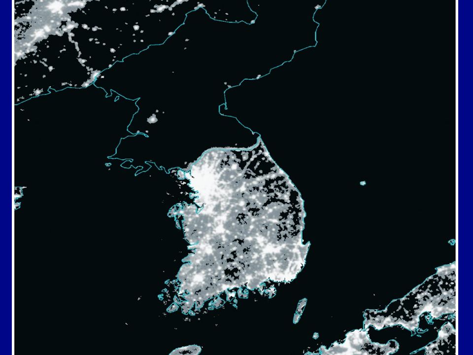
Problems of defining states Almost all habitable land belongs to a country today In 1940, there were about 50 countries Today, there are 192 countries (as evidenced by United Nations membership) Some places are difficult to classify Korea: One state or two? Western Sahara (Sahrawi Republic) Claims to polar regions
 Some places are difficult to classify. Korea: One state or two Western Sahara (Sahrawi Republic) Claims to polar regions.")
4
National Claims to Antarctica

5
National Claims to Arctic

6
United Nations Members
Figure 8-2

7
Nations: When added to UN
Figure 8-5

8
Where Are States Located?
Varying sizes of states State size varies considerably Largest state = Russia 11 percent of the world’s land area Smallest state = Monaco Microstate = states with very small land areas About two dozen microstates

9
Where Are States Located?
Development of the state concept Ancient states The Fertile Crescent City-state Early European states Colonies Three motives: “God, gold, and glory” Today = some remaining colonies

10
Colonial Possessions, 1914 Figure 8-8

11
Colonial Possessions, 2006 Figure 8-9

12
Why Do Boundaries Between States Cause Problems?
Shapes of states Five basic shapes Compact = efficient Elongated = potential isolation Prorupted = access or disruption Perforated = South Africa Fragmented = problematic Landlocked states

13
Shapes of States in Southern Africa
Figure 8-10

14
Why Do Boundaries Between States Cause Problems?
Types of boundaries Physical Desert boundaries Mountain boundaries Water boundaries Cultural Geometric boundaries Human features (language, religion, ethnicity) Frontiers
 Frontiers.")
15
Mountain Boundary Figure 8-12

16
Cultural Boundary Figure 8-15

17
Why Do Boundaries Between States Cause Problems?
Boundaries inside states Unitary states Example: France Federal states Example: Poland Globally, there is a trend toward federations

18
Why Do Boundaries Between States Cause Problems?
Electoral geography Boundaries within the United States are used to create legislative districts Gerrymandering Three types: wasted, excess, and stacked vote Illegal (1985 U.S. Supreme Court decision)
")
19
Gerrymandering Figure 8-18

20
Gerrymandering: Example
Figure 8-19

21
Gerrymandering: Example

22
Gerrymandering: Example

23
Why Do States Cooperate with Each Other?
Political and military cooperation The United Nations (est. 1945) Regional military alliances Balance of power Post–World War II: NATO or the Warsaw Pact Other regional organizations OSEC (est. 1965) OAS (est. 1962) AU (est. 1963) The Commonwealth Economic cooperation
 Regional military alliances. Balance of power. Post–World War II: NATO or the Warsaw Pact. Other regional organizations. OSEC (est. 1965) OAS (est. 1962) AU (est. 1963) The Commonwealth. Economic cooperation.")
24
Economic and Military Alliances in Cold War Europe
Figure 8-21

25
Why Has Terrorism Increased?
Systematic use of violence to intimidate a population or to coerce a government From the Latin word meaning “to frighten” Use of bombing, kidnapping, hijacking, and murder to instill fear and anxiety in a population

26
Why Has Terrorism Increased?
Terrorism by individuals and organizations American terrorists September 11, 2001, attacks Al-Qaeda Jihad

27
Aftermath of World Trade Center Attack
Figure 8-23

28
Why Has Terrorism Increased?
State support for terrorism Three increasing levels of involvement Providing sanctuary Supplying weapons, money, and intelligence to terrorists Using terrorists to plan attacks

29
Why Has Terrorism Increased?
State support for terrorism Examples Libya Iraq Afghanistan Iran Pakistan

30
Ethnic Groups in Southwest Asia
Figure 8-25

31
Major Tribes in Iraq Figure 8-26

32
The End. Up next: Development

Similar presentations


 geographer.>")


>")


