Download presentation
Presentation is loading. Please wait.

1
Chapter 21 East Africa

2
The Great Rift Valley

3
Great Rift Valley

4
A rift valley is a crack in the Earth’s surface and is a defining feature of the East African landscape. The Great Rift Valley is made up of two branches. The Western Rift Valley cuts through Tanzania, Burundi, Rwanda, and Uganda. The Western Rift Valley is where Lake Tanganyika is found, which is one of the longest and deepest freshwater lakes in the world. The Eastern Rift Valley cuts through Tanzania, Kenya, and Ethiopia. The Eastern Rift Valley has Africa’s two major mountains: Kilimanjaro and Kenya.

5
# 4,000 miles long # The Great Rift Valley is rich in minerals and metals # Good soil for farming # Because of volcanic ash there are well preserved bones and the world’s oldest human fossils have been found there

6
Mountains of East Africa

7
Volcanoes Near rift valleys Eastern Congo Mt. Kenya Mt. Kilimanjaro…

8
Mountains Sub-Saharan Africa does not have large mountain ranges, but there are several tall mountains that are volcanoes. In East Africa, the mountains are found in the Eastern Highlands, part of the Ethiopian Plateau.

9
Mount Kilimanjaro Africa’s most recognized feature Tallest mountain in Africa Famous snow cap is disappearing (Will be gone in a few years)
")
10
Mt. Kenya

11
Ruwenzori Mountains This is another mountain range found in East Africa. It divides Uganda and the Democratic Republic of the Congo. This mountain range is covered with snow and cloaked in clouds. It’s nickname is the “Mountains of the Moon.”

12
Lakes of East Africa

14
Rift Valleys Often have long, narrow lakes

15
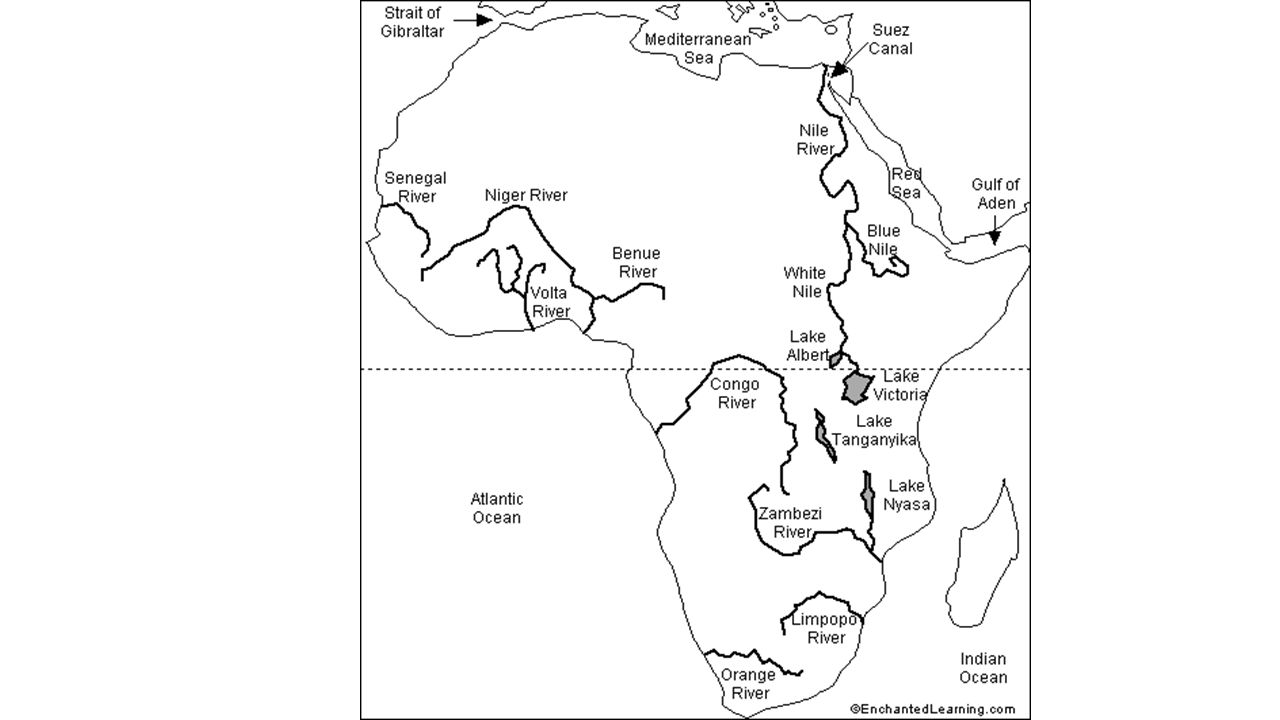
Lake Victoria Africa’s largest lake by area largest tropical lake in the world world's second largest freshwater lake by surface area Africa's largest inland fishery

16
Lake Victoria It is located along the borders of Uganda, Tanzania, and Kenya between the Eastern and Western Rift Valleys. It was formed over 10,000 years ago. Lake Victoria lies at the headwaters of the White Nile River. It is a shallow lake with a depth of only 270 feet. Has provided means of transportation between Uganda, Kenya, and Tanzania with ferry ports in each country. It is nearly twice the size of Lake Tanganyika.

17
Lake Tanganyika Is found in the Western Rift Valley. It is one of the deepest freshwater lakes in the world. It is located between Tanzania and the Democratic Republic of the Congo. Both Lake Victoria and Lake Tanganyika are surrounded by rich soil and are known for abundant fishing. These characteristics have resulted in the area around both lakes to be heavily populated.

18
Lake Turkana It is found in Kenya along the northern border in Ethiopia. It is a source of growing wind-power and hydroelectric industries in Kenya. Lake Turkana has rocky shores in the east and south due to volcanic outcrops. It lies in a part of the Eastern Rift Valley that get little rain, so it is surrounded by desert. The lake had once been part of a larger lake, but due to desertification, it has shrunk. In the west and north, the lake is marked by sand dunes, sandpits, and mudflats.

19
Lake Turkana

20
Plateaus

21
Continent of Plateaus Africa as a continent is often described as “One Big Plateau” Coastal plains go 20 miles inland. The it is plateau after plateau & in between there are escarpments. The East African plateaus range in elevation from 500 feet to 8,000 feet or more. Escarpments- steep cliffs or slopes Due to the plateaus and escarpments of East Africa, their rivers are known to have many cataracts (rapids) and large waterfalls.
 and large waterfalls..")
22
Plateau’s Impact on Rivers Depth varies depending on the season-if it’s the rainy season or the dry season Plateaus prevent easy navigation due to water falls. Therefore, the interior of Africa remained largely unexplored Therefore, the interior of Africa remained largely unexplored

23
Plateau’s Impact on Rivers

24
Blue Nile Falls

25
Ethiopian Plateau A rugged mass of mountains in Ethiopia Sometimes called the “Roof of Africa” Includes gorges, river channels, and AMBAS, steep-sided flat-topped lands. Contain grasslands, woodlands and desert areas

26
Ethiopian Highlands Canyons carved by water

27
Highland’s Climate Moderate climate with comfortable temperatures and adequate rainfall. Good for farming. Lower temperatures than savanna due to the high elevation. So snow is common at the higher elevations. Has green farmlands and protected forests.

28
Savanna

29
Tropical grasslands with scattered trees. Rainfall is seasonal alternating between rainy and dry seasons. The wettest areas are closest to the equator---there are six months of almost daily rainfall followed by six months of dry seasons. The annual rainfall is about 35 to 45 inches. This area is found in Kenya, Uganda, Tanzania, Rwanda, and Burundi. The soil is the savanna is not very fertile.

30
The African Savanna: 13 million sq. mi.

31
Tropical Wet & Dry Climate: The African Savanna # The savanna is the largest climate zone in Africa covering over ½ of the continent # Unpredictable rainfall can lead to drought (long periods with little or no rain)
")
32
Serengeti Plain One of the world’s largest savanna plains There are three types of grasses found here: short, medium, and tall. These grasslands make up a suitable home for millions of animals like zebras, gazelles, hyenas, lions, giraffes, and cheetahs.

33
Serengeti Plains hosts the largest mammal migration in the world contains several national parks and game reserves diverse species due to diverse habitats ranging from riverine forests, swamps, grasslands and woodlands

34
Savanna Today, the plains boast a wide range of cultures, from Maasai nomads to Kikuyu farmers and Dorobo hunter-gatherers. For thousands of years, the region's rhythm of life remained unchanged. But now, sporadic droughts, soil erosion and overgrazing are tiring the land out, while demands on it from impoverished human populations continue to grow.

36
Maasai: Nomadic Herding Tribe in Savannah

37
Savanna Maasai Nomadic Herding of Cattle

38
Modern Maasai Reduced territory, less grazing land Conflict with farmers > sedentism, = poor diet Access to seasonal wetlands Have to migrate with cattle Politically marginalized Forced to adopt non-pastoralist economic activities

40
Natural Resources of East Africa

41
Natural Resources Tanzania: major gold and natural gas deposits, diamonds, and tanzanite Ethiopia: gold Uganda: copper Kenya: minerals like soda ash used for glassmaking and agriculture Burundi: agriculture and known for its coffee Rwanda: agriculture and natural gas Tourism: waterfalls like Victoria Falls, climbing Mount Kilimanjaro, going on a safari in the savanna

Similar presentations


 Many geographic.>")


