Download presentation
Presentation is loading. Please wait.

1
Spatial Databases ted.habermann@noaa.gov and Metadata

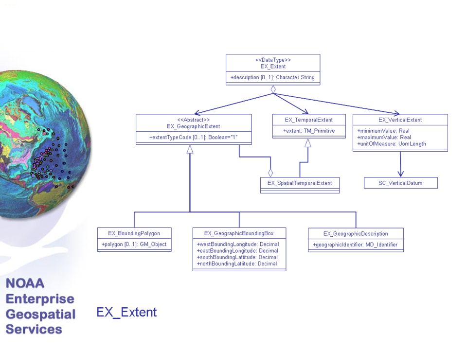
2
Spatial Database Foundation

3
Spatial Operators ST_Area(),ST_AsBinary(),SE_AsShape(),ST_AsText(),ST_Boundary(),SE_Bound ingBox(),ST_Buffer(),ST_Centroid(),ST_Contains(),ST_ConvexHull(),ST_Coor dDim(),SE_CreateSRID(),SE_CreateSrtext(),ST_Crosses(),ST_Difference(),ST_Di mension(),ST_Disjoint(),SE_Dissolve(),ST_Distance(),ST_EndPoint(),ST_Envel ope(),SE_EnvelopesIntersect(),ST_Equals(),ST_ExteriorRing(),SE_Generalize(), ST_GeometryN(),ST_GeometryType(),SE_GeomFromShape(),ST_GeomFrom Text(),ST_GeomFromWKB(),ST_InteriorRingN(),ST_Intersection(),ST_Interse cts(),SE_Is3D(),ST_IsClosed(),ST_IsEmpty(),SE_IsMeasured(),ST_IsRing(),ST_Is Simple(),ST_IsValid(),ST_Length(),SE_LineFromShape(),ST_LineFromText(),ST _LineFromWKB(),SE_LocateAlong(),SE_LocateBetween(),SE_M(),SE_Midpoi nt(),SE_MlineFromShape(),ST_MLineFromText(),ST_MlineFromWKB(),SE_M max()andSE_Mmin(),SE_MpointFromShape(),ST_MPointFromText(),ST_MPo intFromWKB(),SE_MpolyFromShape(),ST_MPolyFromText(),ST_MPolyFrom WKB(),SE_Nearest()andSE_NearestBbox(),ST_NumGeometries(),ST_NumInt eriorRing(),ST_NumPoints(),ST_Overlaps(),ST_Perimeter(),ST_Point(),SE_Poi ntFromShape(),ST_PointFromText(),ST_PointFromWKB(),ST_PointN(),ST_P ointOnSurface(),SE_PolyFromShape(),ST_PolyFromText(),ST_PolyFromWKB( ),ST_Polygon(),ST_Relate(),SE_Release(),SE_ShapeToSQL(),SE_SpatialKey(),ST _SRID(),ST_StartPoint(),ST_SymDifference(),ST_Touches(),SE_Trace(),ST_Tran sform(),ST_Union(),ST_Within(),ST_WKBToSQL(),ST_WKTToSQL(),ST_X(),S E_Xmax()andSE_Xmin(),ST_Y(),SE_Ymax()andSE_Ymin(),SE_Z(),ST_Zmax(), Lots of Functions / Operators
,ST_AsBinary(),SE_AsShape(),ST_AsText(),ST_Boundary(),SE_Bound ingBox(),ST_Buffer(),ST_Centroid(),ST_Contains(),ST_ConvexHull(),ST_Coor dDim(),SE_CreateSRID(),SE_CreateSrtext(),ST_Crosses(),ST_Difference(),ST_Di mension(),ST_Disjoint(),SE_Dissolve(),ST_Distance(),ST_EndPoint(),ST_Envel ope(),SE_EnvelopesIntersect(),ST_Equals(),ST_ExteriorRing(),SE_Generalize(), ST_GeometryN(),ST_GeometryType(),SE_GeomFromShape(),ST_GeomFrom Text(),ST_GeomFromWKB(),ST_InteriorRingN(),ST_Intersection(),ST_Interse cts(),SE_Is3D(),ST_IsClosed(),ST_IsEmpty(),SE_IsMeasured(),ST_IsRing(),ST_Is Simple(),ST_IsValid(),ST_Length(),SE_LineFromShape(),ST_LineFromText(),ST _LineFromWKB(),SE_LocateAlong(),SE_LocateBetween(),SE_M(),SE_Midpoi nt(),SE_MlineFromShape(),ST_MLineFromText(),ST_MlineFromWKB(),SE_M max()andSE_Mmin(),SE_MpointFromShape(),ST_MPointFromText(),ST_MPo intFromWKB(),SE_MpolyFromShape(),ST_MPolyFromText(),ST_MPolyFrom WKB(),SE_Nearest()andSE_NearestBbox(),ST_NumGeometries(),ST_NumInt eriorRing(),ST_NumPoints(),ST_Overlaps(),ST_Perimeter(),ST_Point(),SE_Poi ntFromShape(),ST_PointFromText(),ST_PointFromWKB(),ST_PointN(),ST_P ointOnSurface(),SE_PolyFromShape(),ST_PolyFromText(),ST_PolyFromWKB( ),ST_Polygon(),ST_Relate(),SE_Release(),SE_ShapeToSQL(),SE_SpatialKey(),ST _SRID(),ST_StartPoint(),ST_SymDifference(),ST_Touches(),SE_Trace(),ST_Tran sform(),ST_Union(),ST_Within(),ST_WKBToSQL(),ST_WKTToSQL(),ST_X(),S E_Xmax()andSE_Xmin(),ST_Y(),SE_Ymax()andSE_Ymin(),SE_Z(),ST_Zmax(), Lots of Functions / Operators")
4
ArcIMS Site and Data Links

5
Map with Multiple Data Layers Points, Lines and Polygons

6
OGC Web Map Services

7
NOSA on Google Earth

8
Advanced Spatial Tools Aeronomy Lab EPA Emissions Viewer Extract Point Data Tool Grid Totals Report Tool NOAA Weather Radio Viewer Report on Transmitter Coverage Tool

9
Extract Point Data Tool Attribute information extracted for all data points in active layer Clipped to current map extent Extracted to g-zipped, tab-delimited, text file (.gz extension) Data then used with software of choice
 Data then used with software of choice")
10
Extract Point Data Tool

11
Grid Totals Report Tool Grid emission totals for all emission species reported (regardless of which layer is visible or active) Clipped to current map extent or area of interest defined by Select by Rectangle tool Report includes totals for point, area, nonroad and onroad emission sources, plus a total for all sources, per species Bounding coordinates and total area selected (in km 2 ) included Report displayed in HTML format
 Clipped to current map extent or area of interest defined by Select by Rectangle tool Report includes totals for point, area, nonroad and onroad emission sources, plus a total for all sources, per species Bounding coordinates and total area selected (in km 2 ) included Report displayed in HTML format")
12
Grid Totals Report Tool

13
Transmitter Coverage Tool Reports on all NWR transmitter footprints that intersect the line feature of interest, clipped to current map extent NWR transmitter Call Sign and length of each feature intersecting the highway provided Length and percent of highway not covered by transmitters also presented, plus these areas highlighted on map in yellow Line/polygon intersection query

14
Transmitter Coverage Tool

16
Datasets, Data Quality, Sources

17
DQ_Result Or QE_CoverageResult + spatialRepresentationType: vector, grid, video, … + resultFile [1]: MX_DataFile + resultFormat [1]: MD_format Format conformance (HDF5 / netCDF) Grids of quality flags, Quality features Or DQ_QuantitativeResult + valueType [0..1] : RecordType + valueUnit : UnitOfMeasure + errorStatistic [0..1] : CharacterString + value [1..*] : Record DQ_ConformanceResult + specification : CI_Citation + explanation : CharacterString + pass : Boolean
![DQ_Result Or QE_CoverageResult + spatialRepresentationType: vector, grid, video, … + resultFile [1]: MX_DataFile + resultFormat [1]: MD_format Format conformance (HDF5 / netCDF) Grids of quality flags, Quality features Or DQ_QuantitativeResult + valueType [0..1] : RecordType + valueUnit : UnitOfMeasure + errorStatistic [0..1] : CharacterString + value [1..*] : Record DQ_ConformanceResult + specification : CI_Citation + explanation : CharacterString + pass : Boolean](http://images.slideplayer.com/27/8966512/slides/slide_17.jpg "DQ_Result Or QE_CoverageResult + spatialRepresentationType: vector, grid, video, … + resultFile [1]: MX_DataFile + resultFormat [1]: MD_format Format conformance (HDF5 / netCDF) Grids of quality flags, Quality features Or DQ_QuantitativeResult + valueType [0..1] : RecordType + valueUnit : UnitOfMeasure + errorStatistic [0..1] : CharacterString + value [1..*] : Record DQ_ConformanceResult + specification : CI_Citation + explanation : CharacterString + pass : Boolean")
Similar presentations


 October 28, 2004 Database Issues.>")


