Download presentation
Presentation is loading. Please wait.

1
Comparison of Benthic Invertebrate Communities Upstream and Downstream of Proposed Culvert Installations in Alabama Amy C. Gill USGS, Alabama Water Science Center

2
Problem Concerns have arisen concerning the use of culverts at highway crossings of streams. The primary concerns are the culvert’s impact on: Stream Geomorphology Suspended Sediment Concentrations Turbidity Stream Biology/Ecology

3
Study Design ALDOT and USGS are conducting a scientific investigation to determine the impacts of culverts on streams. Evaluate 8 to 10 proposed culvert construction sites. Before, during, and post construction Coastal Plain sites Basins having little to no anthropogenic influence (stable streams) are targeted. Data will be used to improve culvert installation, if possible.
 are targeted. Data will be used to improve culvert installation, if possible..")
4
Site Selection Eight sites located in Lamar, Tuscaloosa, Bibb, Russell, Choctaw, and Clarke Counties. Drainage areas range from 0.39 to 16.4 mi 2 Channel slopes range from 9 to 65 ft./mi Channel widths range from 12 to 35 ft. Stream Ecology Site

5
Stream Geomorphology Changes in channel banks, bed, and slope. Scour and fill Reach length 20 times the channel width (22 cross sections) Reach upstream and downstream of proposed culvert Pre-construction survey and 2 years post- construction survey
 Reach upstream and downstream of proposed culvert Pre-construction survey and 2 years post- construction survey.")
6
Streamflow, Turbidity, and Suspended Sediment Concentrations Event-driven (storm events) Site specific – upstream vs. downstream comparison For different flow magnitudes For pre-construction, construction, and post- construction sampling periods

7
Potential Effects of Poor Culvert Design or Placement Barriers to animal passage Fish Invertebrates Loss of riparian and instream habitat complexity Reduced downstream movement of large woody debris Scouring due to increased velocities Thermal differences Increased algal growth in response to loss of riparian cover Shifts in invertebrate communities to scrapers and grazers

8
Benthic Macroinvertebrates Sampled as indicator of stream biological/ecological health Important for food chain Indicator for measuring sedimentation impact Both population and diversity important Site specific – upstream vs. downstream comparison For pre-construction and post-construction sampling periods

9
Collect & identify benthic invertebrates at cross- sections above and below the culvert. Collect & identify benthic invertebrates at cross- sections above and below the culvert. Use functional feeding group information to look at community changes caused by existence of the culvert Use functional feeding group information to look at community changes caused by existence of the culvert Spring/summer collections before and after culvert construction Spring/summer collections before and after culvert construction Approach

10
Methods Visual survey of available instream habitats both upstream & downstream. Collection of invertebrates by netting, scraping, brushing from the richest habitats available.

11
Methods 500-micron mesh nets and sieves Composite sample into 5 gallon buckets Reduced sample volume as much as possible by inspection and removal of larger woody debris Attempt to keep upstream and downstream sampling efforts comparable Same number of woody snags, length of root/bank, etc. Similar amount of sampling time

12
USGS National Water Quality Laboratory Biological Unit 100-counts of invertebrates were identified from each sample by the USGS National Water Quality Laboratory in Denver, Colorado

13
The Invertebrate Data Analysis System – IDAS Summarizes invertebrate data Calculates sample metrics Self-archives settings and stores output in Excel files

14
Comparison of upstream and downstream reaches at each site Comparison of upstream and downstream reaches at each site Are differences observed at all or some of the sites? Are differences observed at all or some of the sites? Analysis

15
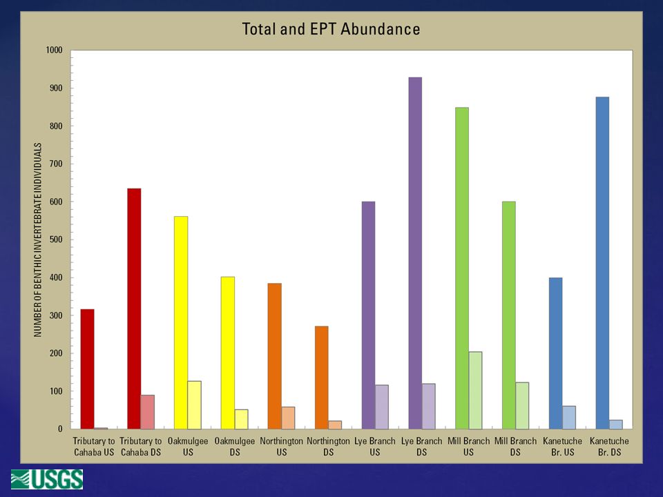
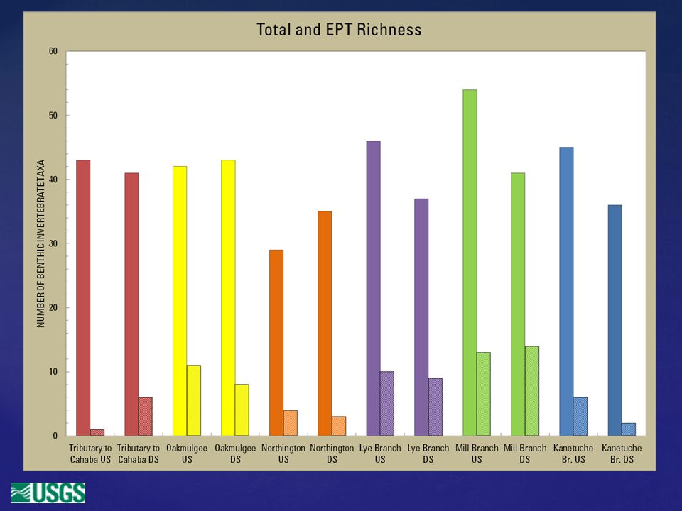
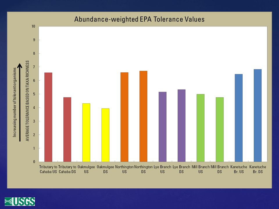
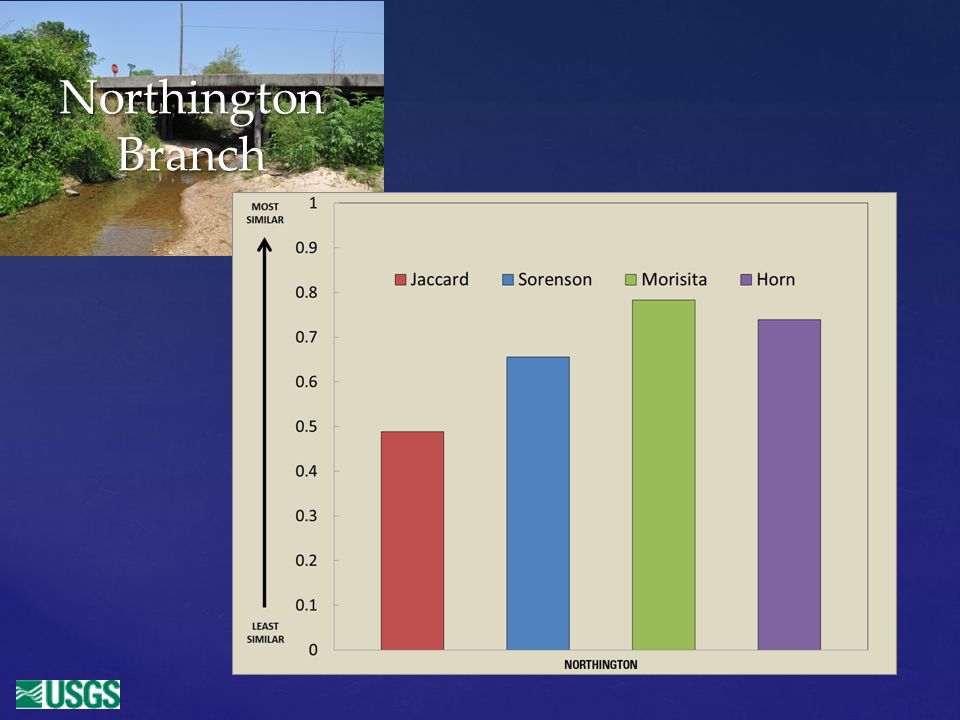
Abundance – numbers of individuals Total Numbers of Taxa EPT Taxa – Ephemeroptera, Plecoptera, Trichoptera Tolerance to impaired water quality Functional Feeding Groups Similarity Indices Community Metrics

19
Oakmulgee

20
Oakmulgee

21
Northington Branch

23
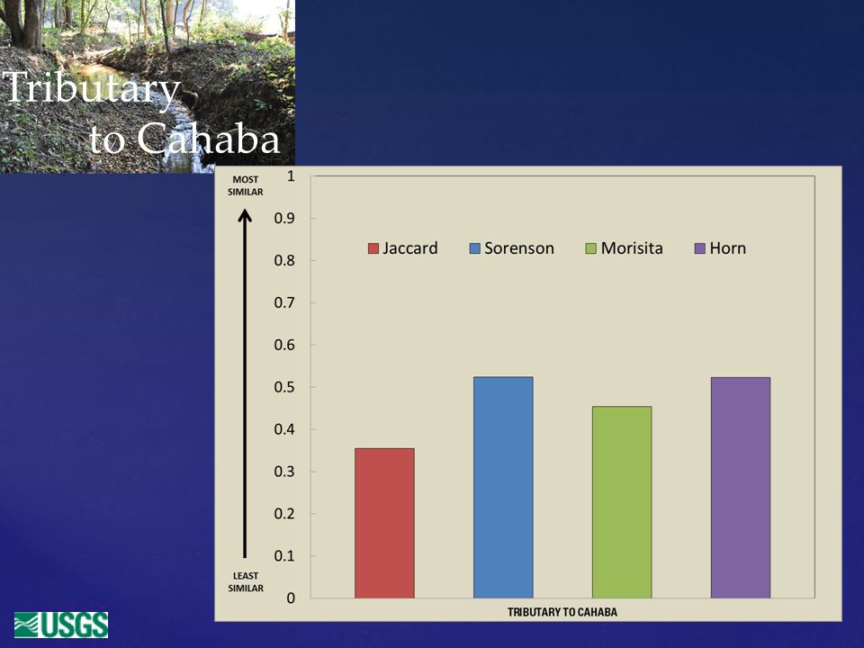
Tributary to Cahaba

25
Most sites have relatively pollution intolerant communities, good abundance and taxa richness values. Most sites have relatively pollution intolerant communities, good abundance and taxa richness values. Upstream and downstream samples did not reflect nearly identical communities like we had expected. Upstream and downstream samples did not reflect nearly identical communities like we had expected. Feeding group structure seems to show promise as a way to identify changes in the site pairs. Feeding group structure seems to show promise as a way to identify changes in the site pairs. Preliminary Findings

26
Continue working with this data to see if we can find better ways to see differences and similarities. Continue working with this data to see if we can find better ways to see differences and similarities. Summarize taxa in different ways (ambiguous taxa, metrics at a different taxonomic level) Summarize taxa in different ways (ambiguous taxa, metrics at a different taxonomic level) Look at the changes in this data along with geomorphology and sediment transport data. Look at the changes in this data along with geomorphology and sediment transport data. Prepare to do post-construction sampling using what we have already learned about these sites. Prepare to do post-construction sampling using what we have already learned about these sites. Next Steps
 Summarize taxa in different ways (ambiguous taxa, metrics at a different taxonomic level) Look at the changes in this data along with geomorphology and sediment transport data. Look at the changes in this data along with geomorphology and sediment transport data. Prepare to do post-construction sampling using what we have already learned about these sites. Prepare to do post-construction sampling using what we have already learned about these sites. Next Steps.")
31
Questions?

32
Open canopy Sand and gravel substrate Overhanging vegetation Small woody debris Northington Branch

33
Lye Branch

35
Some of our “Catch” from Oakmulgee Creek.

36
Effects of Culverts on the Natural Conditions of Streams in the Coastal Plain Physiographic Province of Alabama

37
Site Selection Eight sites located in Lamar, Tuscaloosa, Bibb, Russell, Choctaw, and Clarke Counties. Drainage areas range from 0.39 to 16.4 square miles Channel slopes range from 9 to 65 feet/mile Channel widths range from 12 to 35 feet

38
Current Progress All 8 sites have been selected. Geomorphic surveys (pre- construction) completed on 7 out of 8 sites. Event sampling ongoing for sediment and turbidity. Benthic surveys completed (pre-construction).
 completed on 7 out of 8 sites. Event sampling ongoing for sediment and turbidity. Benthic surveys completed (pre-construction)..")
39
The Benthic Bunch

40
Streamflow Turbidity Event driven turbidity sampling (storm events) Site specific – upstream vs. downstream comparison For different flow magnitudes For pre-construction, construction, and post- construction sampling periods.

41
Oakmulgee

Similar presentations


 Jim Geiselman - BPA.>")


>")


 Stream Channel Pattern Substrate Chemical Properties pH Dissolved Oxygen Temperature Nutrients Turbidity.>")


. Background to RBP changes in community/assemblage composition used to evaluate existence and degree of impact.>")