Download presentation
Presentation is loading. Please wait.

1
Chapter Notes 1-1 (Thinking Like A Geographer) Geography - the study of the earth and its people. Greek Origin - “description of the earth” Geographers use 5 geographic themes to study the earth as the home of people: I.Location - Knowing where you are. Position of a place on the Earth’s surface A.There are two kinds of location: 1. Absolute Location – exact spot on earth 2. Relative Location - comparing two places B.Latitude and longitude are imaginary lines that form a grid system. 1. Latitude - called “parallels”; runs east and west. 2. Longitude - called “meridians”; runs north and south

2
C.The equator divides the earth into northern and southern hemispheres. (0 * Latitude) D.The prime meridian divides the earth into eastern and western hemispheres (0* Longitude) E. Hemispheres - one half of the globe. II.Place – refers to the characteristics of a location that make it different. (physical/human) III.Human/Environment Interaction – how people affect, and are affected by, their environment (natural surroundings). IV.Movement – how and why people, ideas, and goods move from place to place V.Region - areas that have features in common. Determined by human traits (language, religion, occupation) or by physical features (landscape, climate).
 D.The prime meridian divides the earth into eastern and western hemispheres (0* Longitude) E. Hemispheres - one half of the globe. II.Place – refers to the characteristics of a location that make it different. (physical/human) III.Human/Environment Interaction – how people affect, and are affected by, their environment (natural surroundings). IV.Movement – how and why people, ideas, and goods move from place to place V.Region - areas that have features in common. Determined by human traits (language, religion, occupation) or by physical features (landscape, climate)..")
3
Chapter Notes 1-1 (A Geographer’s Tools) I.Types of Geography A. Geographers study the physical and human features of people living in a place. B. Geographers also study how people interact with their environment. II. Map Systems A.Maps are a tool geographers use organize information of a place. B.The Global Positioning System (GPS) is a special device that receives a signal from a satellite that gives a location (lat./long). C.The Geographic Information Systems (GIS) helps gather data that is used for special maps.
 is a special device that receives a signal from a satellite that gives a location (lat./long). C.The Geographic Information Systems (GIS) helps gather data that is used for special maps..")
4
Parts of a Map (Geography Skills Handbook) 1. Title - tells the reader what is on the map 2.Legend (Key) - Interprets the colors and symbols and what they represent. 3. Grid System - lines used to find absolute location. 4. Compass Rose - shows direction 5.Scale - shows the relationship between a unit of measure on a map and a unit of measure on the earth.
 - Interprets the colors and symbols and what they represent. 3. Grid System - lines used to find absolute location. 4. Compass Rose - shows direction 5.Scale - shows the relationship between a unit of measure on a map and a unit of measure on the earth..")
5
Map Information A. General Reference Maps Gives the reader such information as location, size, and distance. 1. political: countries borders, states, and cities 2. physical: landforms and water features B. Thematic Maps Gives the reader more specific information, often on a single topic. They show the distribution or amount of something in a certain area. 1. Land Use and Resources 2. Climate and Vegetation

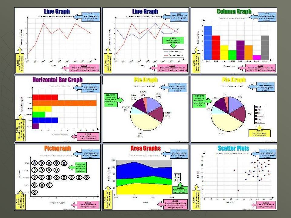
7
Types of Graphs (Geography Skills Handbook) 1.Bar Graphs – use bars to compare data visually
 1.Bar Graphs – use bars to compare data visually")
8
Types of Graphs (Geography Skills Handbook) 1.Line Graphs – show changes over a period of time
 1.Line Graphs – show changes over a period of time")
9
Types of Graphs (Geography Skills Handbook) 1.Circle Graphs – uses a circle to show the whole of something (100%)
 1.Circle Graphs – uses a circle to show the whole of something (100%)")
10
Types of Graphs (Geography Skills Handbook) 1.Charts - present related facts and numbers in an organized way
 1.Charts - present related facts and numbers in an organized way")
11
Types of Graphs (Geography Skills Handbook) 1.Diagrams – drawings that steps in a process, point out the parts of an object, or explains how something works.
 1.Diagrams – drawings that steps in a process, point out the parts of an object, or explains how something works.")
Similar presentations