Download presentation
Presentation is loading. Please wait.

1
Standardized Fire Maps Randy Knippel Dan Castaneda Dakota County Office of GIS

2
Map Book

3
U.S. National Grid

4
Map Pages

5
Street Index

6
Map Legend

7
Map Index

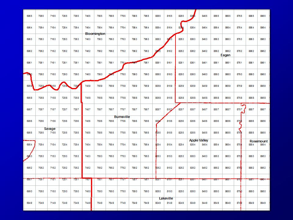
8
Map 8454

9
Street Index Forest Ln.

10
PDF Map Book

11
Maps Online (DCGIS)
")
20
Map VK85

26
United States National Grid (USNG) National standard since 2001National standard since 2001 Adopted by federal agenciesAdopted by federal agencies –FEMA, DHS, NGA, USGS Adopted by several statesAdopted by several states –Florida, Missouri, North Carolina, others –Minnesota (March 25, 2009) Military Grid Referencing SystemMilitary Grid Referencing System –Metric system
 National standard since 2001National standard since 2001 Adopted by federal agenciesAdopted by federal agencies –FEMA, DHS, NGA, USGS Adopted by several statesAdopted by several states –Florida, Missouri, North Carolina, others –Minnesota (March 25, 2009) Military Grid Referencing SystemMilitary Grid Referencing System –Metric system")
27
Why? Multiple gridsMultiple grids –Needed one for everyone Need efficient location referencingNeed efficient location referencing Need interoperabilityNeed interoperability –Across jurisdictions –Local, state, federal, military

28
What about Lat / Long? Not intuitiveNot intuitive –Degrees, minutes, seconds Several formatsSeveral formats –DMS, DMS.sss, DM.mmm, D.ddd –Longitude + / - + / - West / eastWest / east Increases right to leftIncreases right to left

29
What about Lat / Long? How big is a degree?How big is a degree? –It varies 69 miles at the equator69 miles at the equator Longitude gets smaller toward polesLongitude gets smaller toward poles 50 miles in Dakota County50 miles in Dakota County Distance calculations are difficultDistance calculations are difficult

30
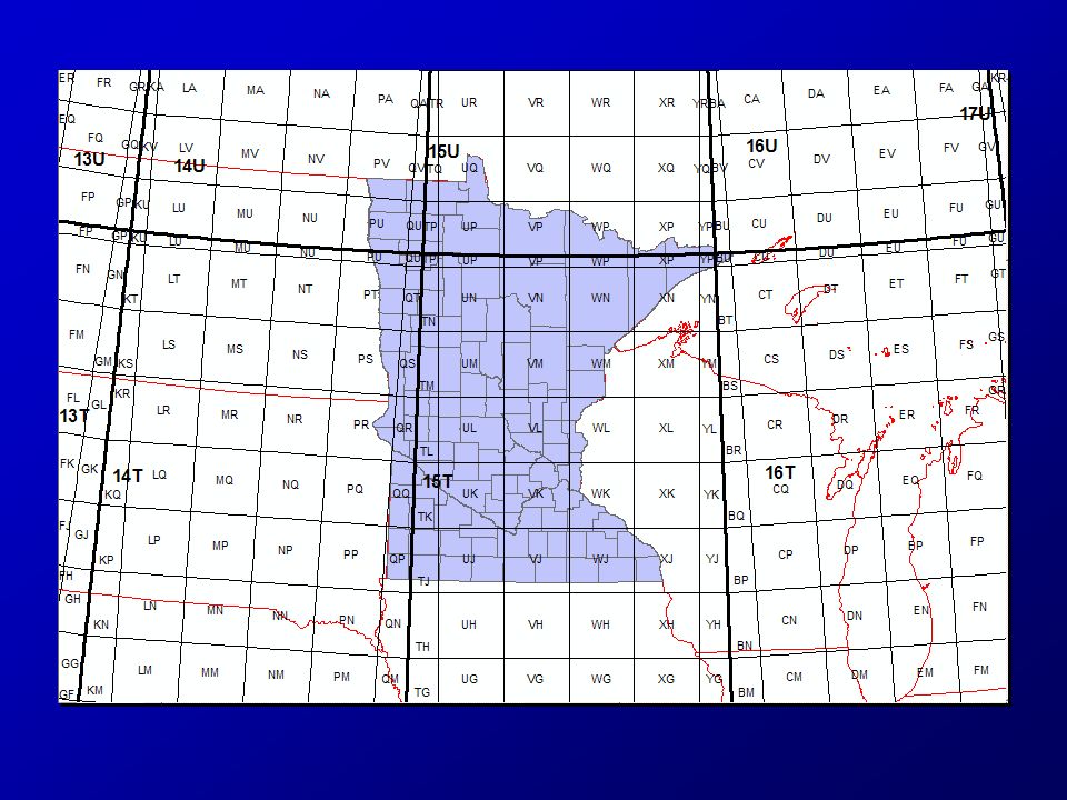
Grid Zone Designation 6 x 8 Degrees

31
100 Km Squares

32
10 Km Squares USNG:15T VK 85

33
1 Km Squares USNG:15T VK 75

35
Map 7456 (15T VK 74 56)
")
36
U.S. National Grid

38
Three Components 18SUJ233710651918SUJ2337106519 18SUJ2337065118SUJ23370651

39
Map VK75 7456

40
841546 (15T VK 841 546) Map 8454 (15T VK 84 54)
 Map 8454 (15T VK 84 54)")
41
Grid Zone Designation (GZD)
")
42
100,000 Meter Square

43
Truncating

47
Key Resources Critical Infrastructure Vulnerable Population

48
Examples What map book page includes Eastview High School?What map book page includes Eastview High School? –8454

49
Examples What is the map book page for 14105 Forest Ln.?What is the map book page for 14105 Forest Ln.? –8454

50
Examples What is the USNG 100m square for 14105 Forest Ln.?What is the USNG 100m square for 14105 Forest Ln.? –15T VK 841 546

51
Examples What is at 15T VK 842 542?What is at 15T VK 842 542? –Trail entrance to Cedar Isle Park

52
Examples What is the USNG 100m square for 13282 Findlay Way?What is the USNG 100m square for 13282 Findlay Way? –15T VK 845 558

53
Examples What is at 15T VK 858 545?What is at 15T VK 858 545? –Scott Highlands Middle School

54
Examples What is at 15T VK 853 551?What is at 15T VK 853 551? –Moeller Park –Trail intersections

55
Examples Find 6565 134 th Ct. W.Find 6565 134 th Ct. W. –15T VK 842 558

Similar presentations


 Randy Knippel – Dakota County GCGI Emergency Preparedness Committee.>")


 – An OverviewU.S. National Grid (USNG) – An Overview Steve Swazee SharedGeo IowaGIC Conference April 8, 2015.>")


What are latitudes and longitudes ? Latitudes and longitudes Are north-south and east-west.>")


