Download presentation
Presentation is loading. Please wait.

1
Unit 1: Geography of Georgia
SS8G1: The student will describe Georgia with regard to physical features and location. August 7, 2015

2
Tell Me What You Know Name the 7 continents: List the 4 oceans:
In 10 minutes tell me everything you know about the state of Georgia. (It can be anything) Number it on your paper.
 Number it on your paper.")
3
What do we know???? Name the 7 continents: List the 4 oceans:

4
What do we know???? Facts about Georgia:

5
Vocabulary Terms to Know SS8G1a
Region: An area with common characteristics such as soil, vegetation, climate, landforms, recreation and economic opportunities. Nation: A territory or country. Continent: One of seven large land masses on Earth. Hemisphere: A half of a sphere or the Earth.

6
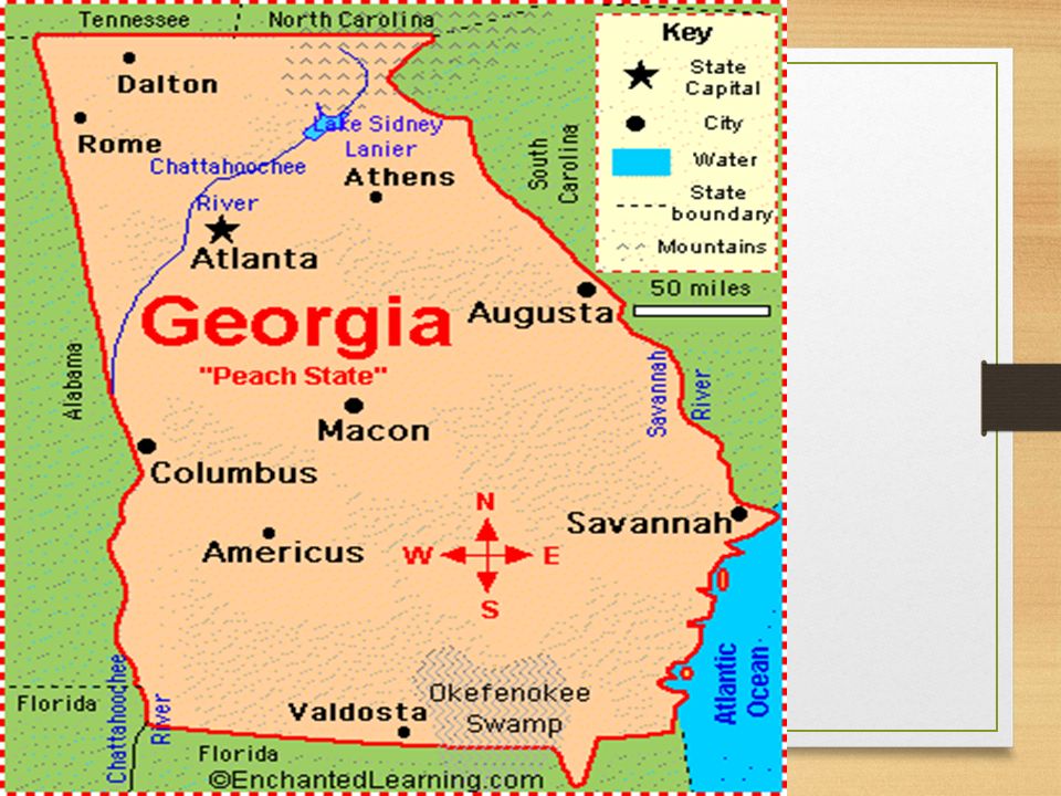
Location SS8G1a Located on the continent of North America
Located in the southeastern region of the USA Georgia is bordered by five states on the: Florida South Carolina Alabama Tennessee North Carolina

7
Location

8
Absolute & Relative Location
Absolute Location: Georgia is between 30 ° 31‘ and 35 ° north latitude; between 81° and 85 ° 53' west longitude. Relative Location: Georgia is surrounded by Tennessee, Alabama, Florida, South Carolina, & North Carolina (5 border states…Review). Georgia is positioned in both the northern and western hemispheres.
. Georgia is positioned in both the northern and western hemispheres.")
9
Location

10
Location Georgia has 159 counties
Georgia is ranked 24th in size among the 50 U.S. states. Largest state east of the Mississippi River. Highest mountain point in Georgia is Brasstown Bald (4,784 feet), which is located in Twiggs County Atlanta is the capital city.
, which is located in Twiggs County. Atlanta is the capital city.")
11
Where in the World is Georgia? Let’s Review
Absolute Location: Relative location: Georgia is bordered by ---states. It is located north of ----, south of -----, etc. Georgia is also bordered by the Ocean Region of the USA: Continent: Hemisphere:

12
Homework: Unit 1 Frayer Models Due: Wednesday, August 12th
The Frayer Model Define the following vocabulary terms using the Frayer Model template: 1. Absolute Location 2. Continent 3. Hemisphere 4. Nation 5. Region 6. Relative Location Vocabulary Word Definition Facts/Characteristics 1. 2. Picture/Example

13
5 Geographic Regions SS8G1b

14
5 Geographic Regions Each of these regions has soil, physical features, and climate that help determine what kinds of animals and plants can live and thrive in it. STOP

15
Unit 1: Geography of Georgia
SS8G1: The student will describe Georgia with regard to physical features and location. August 10, 2015

16
Homework for Monday, August 10, 2015
In a paragraph, please share which state and city you were born in as well as how many states and or countries you have visited, thus far. Please share the names of these states and or countries, too! Finally, share some of your favorite places that you have visited in the state of Georgia (amusement parks, landmarks, camping, mountains, cities, malls, concerts, etc.). Due Tuesday August 11, 2015
. Due Tuesday August 11,")
17
Homework: Unit 1 Frayer Models Due: Thursday , August 13th
The Frayer Model Define the following vocabulary terms using the Frayer Model template: 1. Climate 2. Aquifer 3. Hazardous Waste 4. Weather 5. Piedmont 6. Tornadoes Fall Line (Zone) Hurricanes Vocabulary Word Definition Facts/Characteristics 1. 2. Picture/Example
 Hurricanes. Vocabulary Word. Definition. Facts/Characteristics Picture/Example.")
18
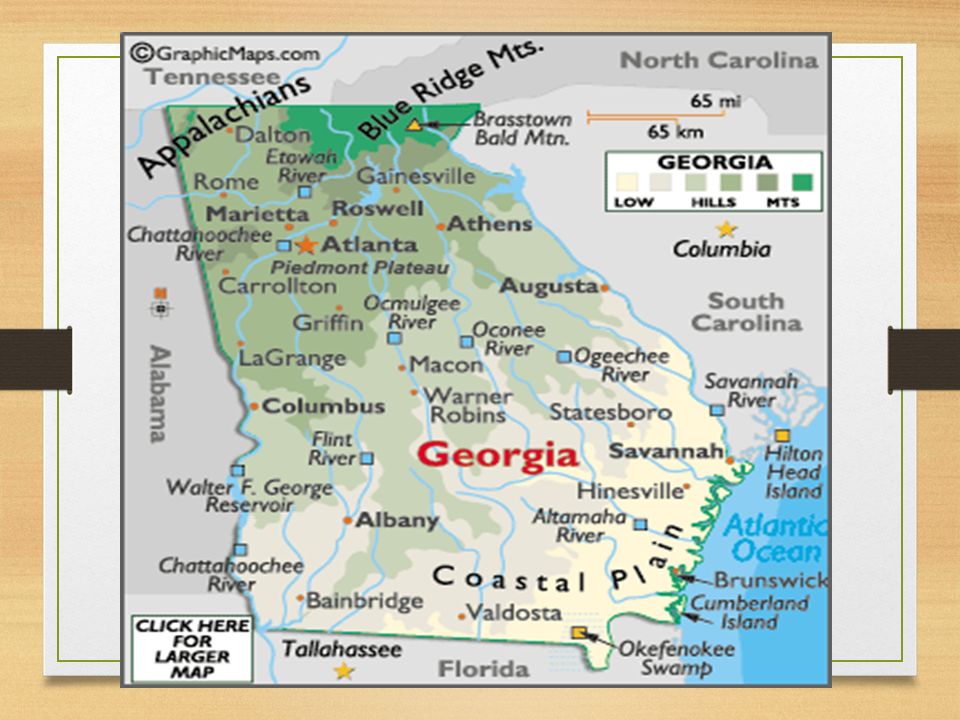
5 Geographic Regions Appalachian Plateau Region: The mountainous region found in the northwestern corner of Georgia. Its most prominent features are Lookout and Cloudland Canyon.

19
5 Geographic Regions Ridge and Valley Region: It occupies most of the northwestern part of Georgia. Forms a series of parallel valleys separated by ridges in the northwest corner of the state. The valleys contain fertile land for farming.

20
5 Geographic Regions Blue Ridge Region: It is located in the northeastern part of Georgia. It consists of mountains, ridges, and basins. Brasstown Bald, Georgia’s tallest mountain, is located in this region.

21
5 Geographic Regions Piedmont Region: It contains a series of rolling hills and occasional isolated mountains (Stone Mountain and Pine Mountain). Rivers and ravines are found throughout this region. Red clay soil is found in this region. ½ of Georgia’s population lives in the Piedmont Region. We live in this region.

22
Fall Line Also known as the Fall Zone
It stretches across the state from Augusta to Columbus. It is the natural boundary that separates the Piedmont and Coastal Plain Regions. Land elevation drops and the water flows at an increase rate. Georgia’s waterfalls are located along the fall line.

23
Physical Features SS8G1c
Fall Line is located between the Piedmont Region and Coastal Plain Region. It is the point at which hilly or mountainous lands meet the coast plain. This is where Georgia’s waterfalls and rapids are found.

24
5 Geographic Regions The Georgia coast is associated with the Coastal Plain Region, a low, flat region of well-drained, gently rolling hills and poorly drained flat woods. The Atlantic Ocean forms the eastern border of the Coastal Plain. The southern border of this province is formed by the Gulf of Mexico, in the state of Florida. This region is divided into the inner and outer Coastal Plains. The Coastal Plain is the largest region in Georgia.

25
MAP ACTIVITY Advance 1 slide 1st period

26
5 Geographic Regions SS8G1b
Add to your map: Atlanta Atlantic Ocean Brasstown Bald Mountain Chattahoochee River Savannah River Okefenokee Swamp Label where Alabama, Tennessee, Florida, North Carolina, and South Carolina are located on your map STOP

27
Unit 1: Geography of Georgia
SS8G1: The student will describe Georgia with regard to physical features and location. August 11th, 2015

28
Physical Features Okefenokee Swamp is a wetland haven for hundreds of plants, animals, and reptiles. This swamp is located in the outer Coastal Plain Region. (12 min)
")
29
Physical Features Georgia two major seaports are: Savannah & Brunswick, GA. Georgia’s rivers are important to the state, because they: Provides habitat for thousands of plant and animal species Transportation routes for ships carrying goods Provide drinking water for many areas Generate hydroelectric power at many dams and cool the reactors at facilities that provide nuclear power in the state Source of recreation for people who like to canoe, kayak, and swim

30
Physical Features 11 Major state rivers are: Etowah River Coosa River
Chattahoochee River Oostanaula River Flint River Chattooga River Savannah River Ogeechee River Oconee River Ocmulgee River Altamaha Rivers

31
Physical Features Along Georgia’s eastern coastline are the Barrier Islands. They are all located in Glynn County. These islands protect Georgia’s beaches on the eastern coastline by blocking wind, sand, and water from eroding the land. These islands are wildlife sanctuaries, recreation, and tourist attractions. Also, known as the “Golden Isles” these islands are named: Tybee, St. Simon, Jekyll, Cumberland, Sea Island, Wassaw, Ossabaw, St. Catherines, and Sapelo.

32
Picture of Barrier Islands

33
Secret Seashore: Georgia’s Barrier Islands (Georgia Public Broadcast, 2011)
Media Clip:

36
Georgia’s Climate SS8G1d
Climate refers to the average weather and patterns of weather of a region over a long period of time. Climate of a region influences the types of homes built, the types of industries that develop, the clothing people wear, and what crops are grown. Georgia’s climate is temperate/mild, which means it rarely has extremes of weather.

37
Climate Georgia’s population continues to grow, with new businesses moving to the state. People have migrated to Georgia from other regions of the USA, due to its temperate/mild climate.

38
Climate Georgia’s rainfall allows for:
Agriculture in much of the state The many rivers and streams provide drinking water Transportation Electric power

39
Climate Georgia is subject to two extreme forms of weather: tornadoes and hurricanes. On average, Georgia has about 20 tornadoes a year (March through May). Tropical storms can turn into hurricanes if their wind speed increases. Hurricanes that affect Georgia begin in the tropical area of Atlanta Ocean, Caribbean Sea or Gulf of Mexico.
. Tropical storms can turn into hurricanes if their wind speed increases. Hurricanes that affect Georgia begin in the tropical area of Atlanta Ocean, Caribbean Sea or Gulf of Mexico.")
40
MAP ACTIVITY

41
5 Geographic Regions of Georgia
Identify Atlanta Atlantic Ocean-blue Brasstown Bald Mountain Chattahoochee River-blue Savannah River-blue Barrier Islands-circle and label Okefenokee Swamp-purple The states that border Georgia Alabama Florida North Carolina South Carolina Tennessee Label and locate on Map 5 Geographic Regions of Georgia Appalachian Plateau-yellow Blue Ridge Region-blue Ridge and Valley-brown Piedmont Region-green Coastal Plain-orange Fall Line-black

42
5 Geographic Regions of Georgia
Identify Atlanta Atlantic Ocean-blue Brasstown Bald Mountain Chattahoochee River-blue Savannah River-blue Barrier Islands-circle and label Okefenokee Swamp-purple The states that border Georgia Alabama Florida North Carolina South Carolina Tennessee Label and locate on Map 5 Geographic Regions of Georgia Appalachian Plateau-yellow Blue Ridge Region-blue Ridge and Valley-brown Piedmont Region-green Coastal Plain-orang Fall Line-black

43
References Caldwell, L. A. (2010). Georgia: Its heritage and its promise. Atlanta, GA: Clairmont Press. Klein, P. (2005). Georgia: In the American Experience. Atlanta, GA: McDougal Littell
. Georgia: Its heritage and its promise. Atlanta, GA: Clairmont Press. Klein, P. (2005). Georgia: In the American Experience. Atlanta, GA: McDougal Littell")
44
Label, locate and color on Map
Identify Atlanta Atlantic Ocean Brasstown Bald Mountain Chattahoochee River Savannah River Barrier Islands Okefenokee Swamp The states that border Georgia Alabama Florida North Carolina South Carolina Tennessee Label, locate and color on Map 5 Geographic Regions of Georgia Appalachian Plateau- Ridge and Valley Piedmont Region- Coastal Plain Fall Line

45
Label, locate and color on Map
Identify Atlanta Atlantic Ocean Brasstown Bald Mountain Chattahoochee River Savannah River Barrier Islands Okefenokee Swamp The states that border Georgia Alabama Florida North Carolina South Carolina Tennessee Label, locate and color on Map 5 Geographic Regions of Georgia Appalachian Plateau- Ridge and Valley Piedmont Region- Coastal Plain Fall Line

Similar presentations
>")


:>")
