Download presentation
Presentation is loading. Please wait.

2
Map Projections

3
Reference Globe Transformation Map Projection Reference Ellipsoid Sphere of Equal Area Geoid 3D-2D Transformation Process

4
Earth as Sphere Most commonly used in cartography –Primarily for small-scale maps

5
Earth as Sphere Size 40 million meters in circumference 20 million meters from Pole-to-Pole 10 million meters from Equator to Pole 1 Meter = 1/10-million of the distance from the equator to the north pole as a line of longitude running through Paris France

6
Reference Globe Transformation Map Projection Reference Ellipsoid Sphere of Equal Area Geoid 3D-2D Transformation Process

7
Reference Globe A reference globe is where the size of the sphere (or other shape) is reduced until it matches the final scale desired for map making
 is reduced until it matches the final scale desired for map making")
8
Reference Globe Transformation Map Projection Reference Ellipsoid Sphere of Equal Area Geoid 3D-2D Transformation Process

9
…Distorting inevitable Projection selection and final transformation from 3d-to-2d 3D-2D Transformation Process

10
Tearing, Shearing & Compression

11
Uncertainty & Errors Need to know where error is and how to control it Which map is more accurate? –Conformal vs. Equal Area

12
Conformal: correct proportions & shape Equal Area: area relationships of all parts are maintained; property of equivalence

13
Map Error: Projections can Preserve Shape –Scale preserved in all directions around a point Preserves local angular relationship –Conformal Maps Area (size) –Equal Area Maps Distance (scale) –Equidistance Maps Direction (azimuth) –Equidirection Maps
 –Equal Area Maps Distance (scale) –Equidistance Maps Direction (azimuth) –Equidirection Maps")
14
No map can be both Conformal & Equal Area

15
Reference Globe Transformation Map Projection Reference Ellipsoid Sphere of Equal Area Geoid 3D-2D Transformation Process

16
Flattening the globe: Map Projections Transforming a globe to a flat map requires distortion of one kind or another …

17
Map projections: classification by surface Earth features are projected on to three kinds of developable surfaces plane: a flat plane touches the globe cylinder: a cylinder is wrapped around the globe, and unwrapped to a flat map cone: a cone is wrapped around the globe, and unwrapped to a flat map

18
Common planar projections Gnomonic Light source

19
Common projections MercatorPeters Equal-area cylindrical Cylindrical

20
Common projections Lambert conformal Albers equal-area Conic

21
Projection surfaces planar (or azimuthal) mathematical surfaces cylindrical conic Developable surfaces Can construct the appearance of each with geometry
 mathematical surfaces cylindrical conic Developable surfaces Can construct the appearance of each with geometry")
22
Some mathematical projections pseudocylindrical pseudoconic

23
Why all the projections? All have distortion of some kind, but … each serves a unique purpose or has a unique property that is useful for a certain application

24
Distortion and accuracy on projections Strategy: compare the projection to a globe (an “unprojected map”) All distances are equal Distances decrease 90° Meridians converge
 All distances are equal Distances decrease 90° Meridians converge")
25
Some questions… accuracy & distortion on projections Can we compare one area to another accurately? Are shapes correct? Are directions from one place to another accurate? Can we compare distances between places? Which parts of the map suffer the most distortion? Property: aspects of the globe that a projection preserves Distortion: aspects that the projection doesn’t preserve

26
Some equal-area projections Albers equal-area Equal-area cylindrical Mollweide pseudocylindrical

27
Shapes, in small areas near the middle of the projection, look the same on the map as they do on the globe As on globe, all meridians & parallels intersect at right angles “Conformal” = angles & shapes (sort of) preserved 90°
 preserved 90°")
28
Directions are preserved: “azimuthal” GOOD FOR: Air navigation, radio signals or radiation patterns Angular measurement from one location to another is accurate Straight lines are great circles Not a great circle! Gnomonic

29
Distances are preserved: “equidistant” = 2000 miles If measured on a line that passes through center Not this line!

30
Area preserved: “equivalent” or “equal-area” = 1 million sq. miles Important for: maps where land area is important

31
Conformal projections and navigation With Mercator: You can use a straight line from origin to destination to determine your compass bearing to the destination Mercator projection But the line isn’t a great circle!

32
Some examples of map types Map purpose Critical Properties for the purpose ConformalEqual-AreaEquidistantAzimuthal Navigation Show distances Large-scale reference Teaching Comparing regions

33
Four Key Projection Properties Equivalence: Equal areas Conformality: Correct angles (rhumb lines = straight lines) Azimuthality: Correct directions (great circles = straight lines) Equidistance: Correct distances Property of a projection = how it’s true to the globe Can’t occur together!
 Azimuthality: Correct directions (great circles = straight lines) Equidistance: Correct distances Property of a projection = how it’s true to the globe Can’t occur together!")
34
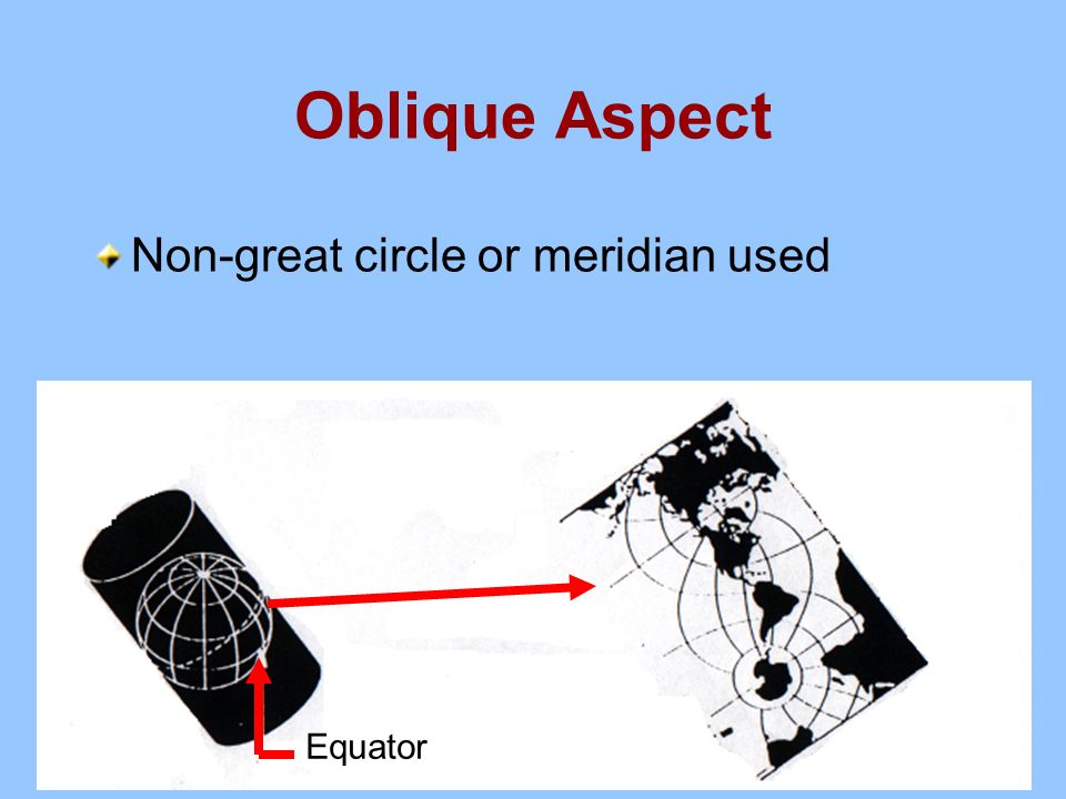
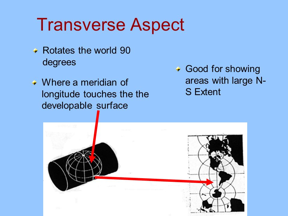
Aspect The orientation of the developable surface to the reference globe Three aspects: equatorial, transverse, and oblique

35
Globe axis parallel to developable surface’s axis A normal aspect = simple map graticule Equatorial Aspect

37
Oblique Aspect Non-great circle or meridian used Equator

39
Transverse Aspect Where a meridian of longitude touches the the developable surface Rotates the world 90 degrees Good for showing areas with large N- S Extent

41
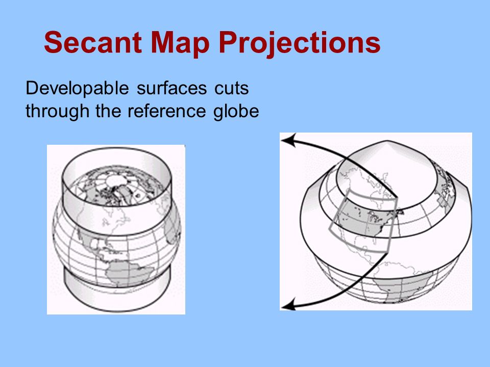
Secant Map Projections Developable surfaces cuts through the reference globe

42
Secant Variations

43
Meeting several needs: Compromise projections Miller Robinson

44
The projection matrix equivalentconformalequidistantazimuthal cylindrical PetersMercatorPlate-CarreeMercator conic Albers equal area Lambert conformal conic Simple conic Lambert conformal conic planar Lambert azimuthal Stereograp hic Azimuthal equidistant Projection surfaces Projection properties

45
What part of a map has the least amount of distortion?

46
Where the projection surface touches the globe Standard point Standard line

47
For what country or region would you choose these surfaces? a. c. b. d.

48
Guidelines Cylindrical or pseudocylindrical: area extending along equator or a meridian Planar: roundish area, anywhere on earth Conic or pseudoconic: area in middle latitudes, extensive east & west Projection surfaces and orientations with areas for which they’re suited:

49
Keys to Choosing Projections What’s the purpose of your map? What types of accuracy (properties) are most important? For maps of portions of the world: What surface and orientation will best fit the area of the world you’re mapping?
 are most important. For maps of portions of the world: What surface and orientation will best fit the area of the world you’re mapping .")
50
Quick Reading Claudius Ptolemaeus (Ptolemy): Representation, Understanding, and Mathematical Labeling of the Spherical Earth
: Representation, Understanding, and Mathematical Labeling of the Spherical Earth")
Similar presentations