Download presentation
Presentation is loading. Please wait.

1
The Use of Geographical Information System to locate the Periurban Fringe Beniamino Murgante Università della Basilicata Facoltà di Ingegneria Potenza murgante@unibas.it Giuseppe Las Casas Università della Basilicata Facoltà di Ingegneria Potenza lascasas@unibas.it www.lisut.org 10th EC-GI & GIS Workshop, ESDI: The State of the Art, Workshop on Spatial Planning and Geographic Information, Warsaw, Poland, June 22-25, 2004 PiergiuseppePontrandolfi Università della Basilicata Facoltà di Ingegneria Potenza pontrandolfi@unibas.it

2
Introduction

3
Is the geographical world a a jig-saw puzzle of polygons or a club-sandwich of data layer? (Couclelis 92)
.")
4
Introduction In the ideal world the statement “the entity has its own identity” means: the geometrical features of the entity do not depend on the surrounding of the entity, the entity can be translated, the shape of the entity does not change when translating the entity, the entity can not be over posed to a different entity, the entity can be posed on the top of a bigger entity. Discreteness rules: (Frank, 1996)
.")
5
Introduction Data Models Processing Stage (Molenaar 1998) Acquisition Oriented data model Query Oriented data model Output Oriented data model (Longley, et al. 2001) Real world Conception Measurement Analyses Uncertainty in conceiving geographic phenomena Uncertainty in measuring and representing geographical phenomena Uncertainty in analyzing geographic phenomena Real World perception
 Real world Conception Measurement Analyses Uncertainty in conceiving geographic phenomena Uncertainty in measuring and representing geographical phenomena Uncertainty in analyzing geographic phenomena Real World perception.")
6
Introduction Data Models Processing Stage (Molenaar 1998) Acquisition Oriented data model Query Oriented data model Output Oriented data model (Longley, et al. 2001) Real world Conception Measurement Analyses Uncertainty in conceiving geographic phenomena Uncertainty in measuring and representing geographical phenomena Uncertainty in analyzing geographic phenomena ROAD Cartographer viewpoint Construction engineer viewpoint Traffic manager viewpoint Uncertainty may be defined as a measure of the difference between the data and the meaning attached to the data by the current user (Zhang and Goodchild, 2002)
 Real world Conception Measurement Analyses Uncertainty in conceiving geographic phenomena Uncertainty in measuring and representing geographical phenomena Uncertainty in analyzing geographic phenomena ROAD Cartographer viewpoint Construction engineer viewpoint Traffic manager viewpoint Uncertainty may be defined as a measure of the difference between the data and the meaning attached to the data by the current user (Zhang and Goodchild, 2002).")
7
Introduction Data Models Processing Stage (Molenaar 1998) Acquisition Oriented data model Query Oriented data model Output Oriented data model (Longley, et al. 2001) Real world Conception Measurement Analyses Uncertainty in conceiving geographic phenomena Uncertainty in measuring and representing geographical phenomena Uncertainty in analyzing geographic phenomena
 Real world Conception Measurement Analyses Uncertainty in conceiving geographic phenomena Uncertainty in measuring and representing geographical phenomena Uncertainty in analyzing geographic phenomena.")
8
Introduction Data Models Processing Stage (Molenaar 1998) Acquisition Oriented data model Query Oriented data model Output Oriented data model (Longley, et al. 2001) Real world Conception Measurement Analyses Uncertainty in conceiving geographic phenomena Uncertainty in measuring and representing geographical phenomena Uncertainty in analyzing geographic phenomena
 Real world Conception Measurement Analyses Uncertainty in conceiving geographic phenomena Uncertainty in measuring and representing geographical phenomena Uncertainty in analyzing geographic phenomena.")
9
Introduction Data Models Processing Stage (Molenaar 1998) Acquisition Oriented data model Query Oriented data model Output Oriented data model (Longley, et al. 2001) Real world Conception Measurement Analyses Uncertainty in conceiving geographic phenomena Uncertainty in measuring and representing geographical phenomena Uncertainty in analyzing geographic phenomena Users Table Vegetation Table Fauna … Logical Model Fauna wolf wildcat fox … Database Vegetation Conifers Hardwood Species, Mediterranean macchia… fauna forest live Conceptual Model Vegetation Fauna observer Real world
 Real world Conception Measurement Analyses Uncertainty in conceiving geographic phenomena Uncertainty in measuring and representing geographical phenomena Uncertainty in analyzing geographic phenomena Users Table Vegetation Table Fauna … Logical Model Fauna wolf wildcat fox … Database Vegetation Conifers Hardwood Species, Mediterranean macchia… fauna forest live Conceptual Model Vegetation Fauna observer Real world.")
10
Introduction Data Models Processing Stage (Molenaar 1998) Acquisition Oriented data model Query Oriented data model Output Oriented data model (Longley, et al. 2001) Real world Conception Measurement Analyses Uncertainty in conceiving geographic phenomena Uncertainty in measuring and representing geographical phenomena Uncertainty in analyzing geographic phenomena SELECT * FROM Customers WHERE [Customer_ID]>243 ORDER BY [Name] Descending
 Real world Conception Measurement Analyses Uncertainty in conceiving geographic phenomena Uncertainty in measuring and representing geographical phenomena Uncertainty in analyzing geographic phenomena SELECT * FROM Customers WHERE [Customer_ID]>243 ORDER BY [Name] Descending.")
11
Introduction Data Models Processing Stage (Molenaar 1998) Acquisition Oriented data model Query Oriented data model Output Oriented data model (Longley, et al. 2001) Real world Conception Measurement Analyses Uncertainty in conceiving geographic phenomena Uncertainty in measuring and representing geographical phenomena Uncertainty in analyzing geographic phenomena 1 2 Data AnalysisSector Synthesis 3 Sintesi Sistemica 4 Sintesi Sistemica Systemic Synthesis Inter-systemic Synthesis Inter-sector Synthesis 5
 Real world Conception Measurement Analyses Uncertainty in conceiving geographic phenomena Uncertainty in measuring and representing geographical phenomena Uncertainty in analyzing geographic phenomena 1 2 Data AnalysisSector Synthesis 3 Sintesi Sistemica 4 Sintesi Sistemica Systemic Synthesis Inter-systemic Synthesis Inter-sector Synthesis 5.")
12
Introduction Data Models Processing Stage (Molenaar 1998) Acquisition Oriented data model Query Oriented data model Output Oriented data model (Longley, et al. 2001) Real world Conception Measurement Analyses Uncertainty in conceiving geographic phenomena Uncertainty in measuring and representing geographical phenomena Uncertainty in analyzing geographic phenomena In the real world each phase of the geographical analysis process increases uncertainty (Longley, et al. 2001)
 Real world Conception Measurement Analyses Uncertainty in conceiving geographic phenomena Uncertainty in measuring and representing geographical phenomena Uncertainty in analyzing geographic phenomena In the real world each phase of the geographical analysis process increases uncertainty (Longley, et al. 2001).")
13
Different typologies of uncertainty, different fuzziness Boundaries are usually treated as a question of threshold definition. A hill-shaped ownership function, can be utilised to represent a spatial attribute which varies from a core area to a background area. The threshold is a horizontal line which defines the passage from an unacceptable ownership value to an acceptable one. Jawahar, Biswas and Ray, 1997 ? 0k!

14
Different typologies of uncertainty Binary Value Description of binary property value 10Atomic (discrete entity non divisible, Intrinsic) 1Plenum (wide scale, contingent boundary) 20Homogeneous (binary distinction, equal-different) 1Heterogeneous (varies in space) 30Discontinous (break between entities) 1Continous (gradual transition between entities) 40Connected (contiguus areas) 1Distributed (non contiguus areas functionally connected) 50Solid 1Fluid 602 - dimensional 13 - dimensional 70Actual 1Non Actual 80Permanent 1Variable (regular, periodic, irregular) 90Fixed 1Moving 100Conventional-defined (administrative or land use boundaries) 1Self - defining (river, roads) 1 0 indeterminate boundaries determinate boundaries Property Indeterminacy Property Couclelis 96
 1Plenum (wide scale, contingent boundary) 20Homogeneous (binary distinction, equal-different) 1Heterogeneous (varies in space) 30Discontinous (break between entities) 1Continous (gradual transition between entities) 40Connected (contiguus areas) 1Distributed (non contiguus areas functionally connected) 50Solid 1Fluid dimensional 13 - dimensional 70Actual 1Non Actual 80Permanent 1Variable (regular, periodic, irregular) 90Fixed 1Moving 100Conventional-defined (administrative or land use boundaries) 1Self - defining (river, roads) 1 0 indeterminate boundaries determinate boundaries Property Indeterminacy Property Couclelis 96")
15
Different typologies of uncertainty Indeterminacy matrix A. Roberts, G. B. Hall, P.H. Calamai 99

16
An Ontology of Uncertainty

17
MAIN QUESTIONS RELATED TO THE STUDY CASE

20
The need of a plan to control building in rural areas. 1980’s Earthquake An enormous insediative process began in the countryside around the Town of Potenza uncontrolled expansion for seventeen years. Spread of the territorial decline hydrogeologic accident phenomena from anthropic uses Abandonment of agricultural soils related to expectations of estate development, especially in areas close to the town Scattering of extra urban insediative system Pauperization of environmental and landscape valuable components

21
Case Study

29
GIS and classification with sharp boundaries

36
First level of suitability Second level of suitability

37
GIS and classification with sharp boundaries Third level of suitability Fourth level of suitability

38
The fuzzy classification

39
Precise Fuzzy analyses Objectives Class 1 Precise Fuzzy Class 2 Class 3 Class 4 1.The first class is an ideal case where it is possible to build a plan with certain objectives based on certain analyses 2.The second class is the case of a plan with crisp boundaries, based on fuzzy analyses. 3.The third class is very frequent in sector plans (e.g. transport) where the need to achieve widely flexible results and the possibility to obtain several alternatives corresponds to a certainty of data. 4.The fourth class is the case of the strategic plan which identifies the fundamental issues and purposes driving the update process. This is a typical cyclic process where all original choices can be modified and the policy is continually made and re-made, avoiding errors related to radical changes in policy. Leung 1988
 where the need to achieve widely flexible results and the possibility to obtain several alternatives corresponds to a certainty of data. 4.The fourth class is the case of the strategic plan which identifies the fundamental issues and purposes driving the update process. This is a typical cyclic process where all original choices can be modified and the policy is continually made and re-made, avoiding errors related to radical changes in policy. Leung")
40
Cheng T. Molenaar M. and Lin H. 2001 The fuzzy classification

41
“Field fuzzyness” Fuzzy as uncertainty in giving an ownership value to all elements for a generic class Ai Φ defines the possibility that any point is a phisical line line (e.g. a river) Uncertainty can be often conceptualized differently under field and object views (Longley et al, 2001)
 Uncertainty can be often conceptualized differently under field and object views (Longley et al, 2001).")
42
“Object fuzzyness” Fuzzy as uncertainty in giving an ownership value to decide if a vectorial entity belongs to class Ai or Aj Φ defines an area where a physical line (e.g. a river) can be Uncertainty can be often conceptualized differently under field and discrete object views (Longley et al, 2001)
 can be Uncertainty can be often conceptualized differently under field and discrete object views (Longley et al, 2001).")
43
Egenhofer M. J. and Herring J. 1991

44
Clementini E. and Di Felice P. 1996 broad boundary ∆A ∆A = A2 − A1 Disjoint and meet

45
The fuzzy classification Areas close to road network

46
The fuzzy classification

47
Areas close to small rural settlements

48
The fuzzy classification

51
1.areas close to the river, 2.upper than 1200 m a.s.l., 3.archaeological sites, 4.landslides 5.areas in hydro-geological hazard.

52
The fuzzy classification Areas in steep slopes

53
The fuzzy classification Areas in forest

54
Case Study The case of study reports the application of legislation requirements to determine the General Land-Use Map which represents the basis of all future town planning instruments in Basilicata Region (Southern Italy).
.")
55
The land use map should represent in 1:10000 scale the real land use and trends according to the classification of three different spatial system: the nature system, the settlement system, the communication system. Case Study

56
Settlements are classified in the following categories: urban settlements, peri-urban settlements, extra-urban settlements. Case Study Peri-urban area Urban core Urban area Rural area Rural core Municipality

57
The peri-urban fringe can be considered alternatively: a ill-defined background between a certain urban core and a certain rural core, defined as grey area, or an area with its own intrinsic organic rules, like the urban and the rural ones. In our case the legislation requirements in order to define the periurban fringe, identify two essential distinctive characters of its settlements: built area without formal organisation and/or abandoned rural areas contiguous to urban centres. Case Study

60
According to this definition some rules have been developed to identify the periurban areas. Inclusive rules: periurban areas are contiguous to built continuous areas; periurban areas are connected to the city centre by road network; periurban areas are characterised by presence of utilities; periurban areas are well connected to urban services; Case Study

61
Rules to identify the periurban areas. Exclusive rules periurban areas must not be contiguous to environmental preservation areas, archaeological sites, heritage areas, periurban areas must not include high slope terrains, periurban areas must not include landslide areas, periurban areas must not include erosion areas, periurban areas must not be contiguous to industrial areas; periurban areas must not include areas planned for future settlements by masterplans. Case Study

62
X---X-X---Periurban areas are well connected to urban services X---------Periurban areas are characterised by presence of utilities X---------Periurban areas are connected to the city centre by road network. X-X-X-X-XXPeriurban areas are well connected to core urban areas P10P9P8P7P6P5P4P3P2P1 Inclusive Rules Case Study

63
---------XPeriurban areas must not include areas for future settlements provided by masterplans X-X-X-X-X-Periurban areas must not be contiguous to industrial sites XXX---X-XXPeriurban areas must not include erosion areas XXX---X-XXPeriurban areas must not include landslide areas X------XXXPeriurban areas must not include high slopes terrain ---------XPeriurban areas must not be contiguous to environmental preservation areas, archeological sites, heritage areas P10P9P8P7P6P5P4P3P2P1 Exclusive Rules Case Study

64
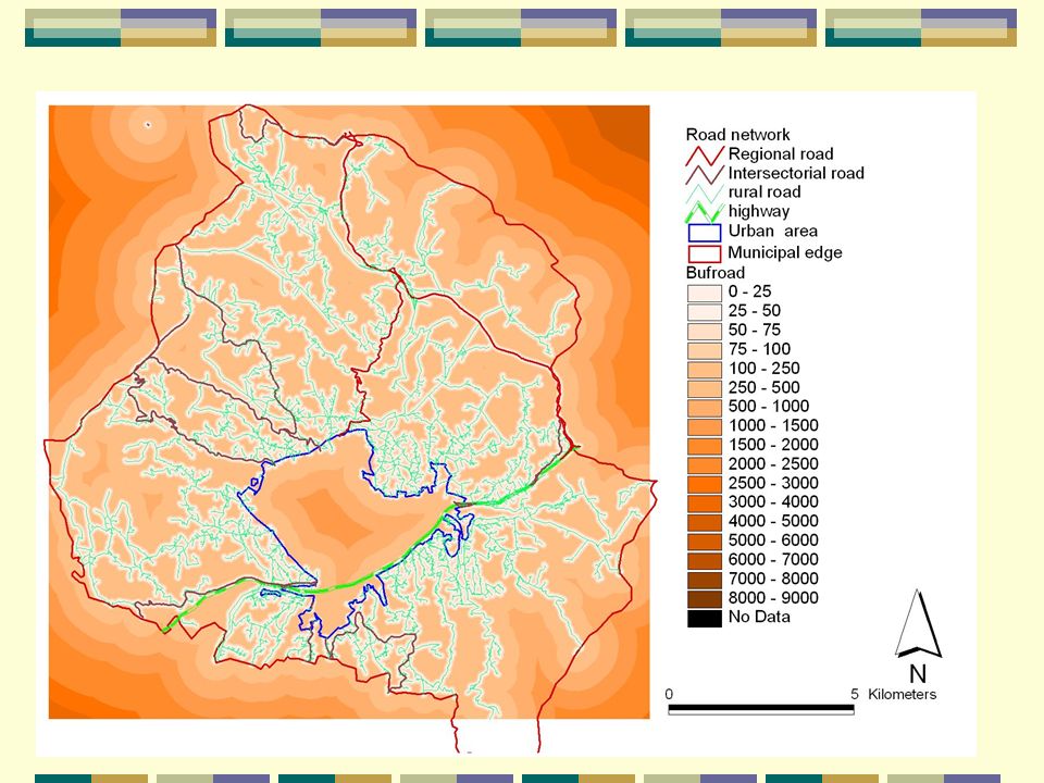
Distance from technological network Distance from urban area

65
Distance from public health services Distance from road network

66
Distance from nursery schoolDistance from compulsory education

Similar presentations


 workshop 8 July 2006, Vienna, Austria International Cartographic Association (ICA) workshop on Geospatial.>")

 John Wiley and Sons Ltd 9. Geographic Data Modeling.>")
 ISO/TC211 Workshop on Standards in Action Adelaide, South Australia October 2001 Mr. Neil Sandercock, SA.>")

 Sources: Berry online text, Dawn Wright.>")


