Download presentation
Presentation is loading. Please wait.

1
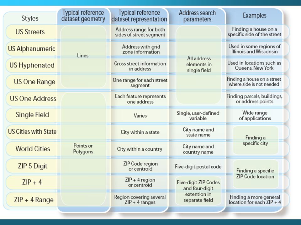
Address matching Very common for: –Crime reports –Customer records –Tax/Parcel records Most common form of ‘geographic’ data (places are located without coordinates) www.gvmc-regis.org/help/esri_manuals/ArcGIS_Desktop/Geocoding_in_ArcGIS.pdf
")
2
Address matching Works by describing a location in relation to known entities State, city, street etc. are all known places The numerical address is simply the last identifier used to locate a place.

3
380 New York St., Redlands, CA, 92373

4
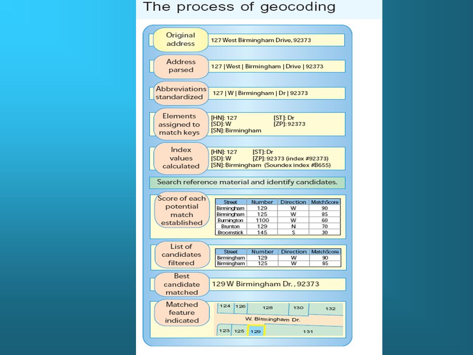
The address matching process. The GIS uses a field by field comparison to generate a match score. Each field is compared and an overall score computed to match the address with a spatial location. The score is normalized to a 100 point value (100 is a perfect match in all fields)
.")
5
The Common US Streets address format International Addresses? FAO Viale delle Terme di Caracella 00100 - Rome Italy Or Istasyon Cad. Bostan Sok. No.6 Yesilkoy 34149 Istanbul/Turkiye

7
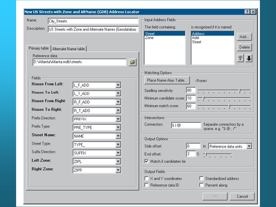
Address matching is an interactive process. In arc map the first step is to create an address locator

10
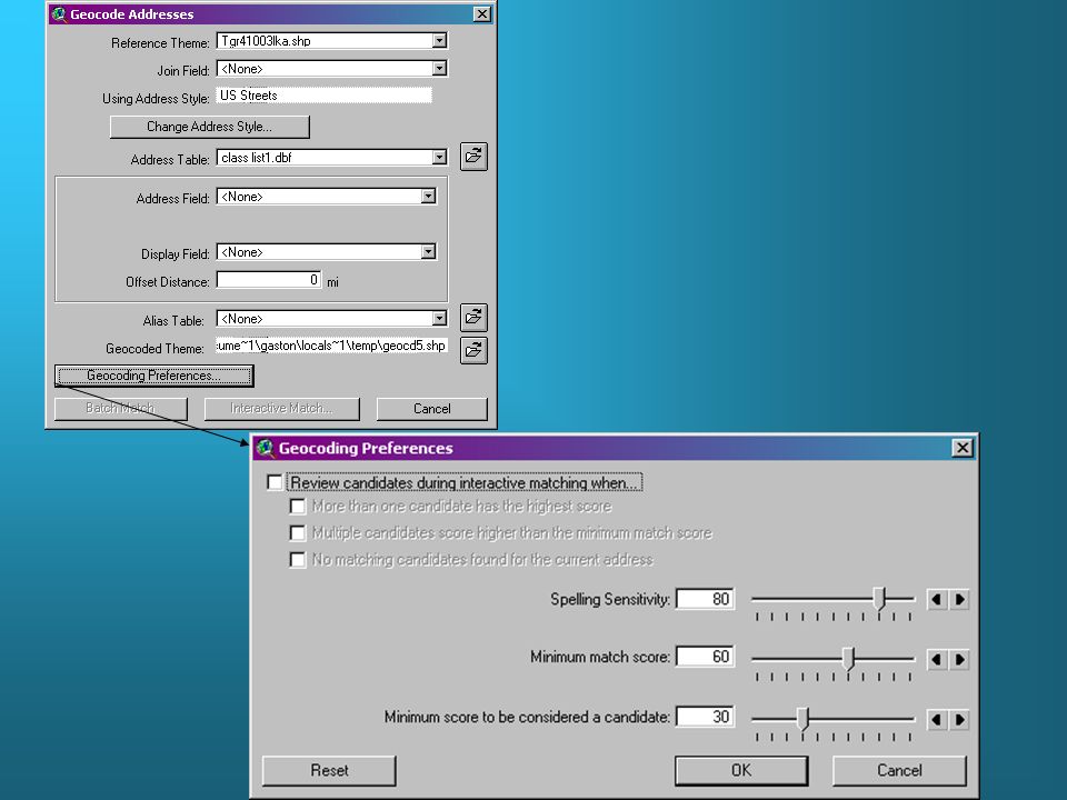
Arcview uses the address fields from the TIGER File to begin locating a given address. Before gecoding an address table, it is necessary to go into the theme/properties tab and set up the geocoding ‘address style’ field.

12
Rates of 45-65% of address correctly matched on the first try are fairly common. The 80% here is pretty good.

13
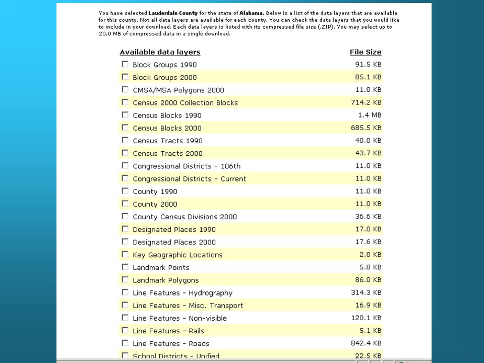
TIGER files Topologically Integrated Geographic Encoding and Referencing Developed for the US Census Bureau, the best base level street maps available.

14
Downloading TIGER files http://www.esri.com/data/download/census2000_tigerline/ http://www.esri.com/data/download/census2000_tigerline/

16
A sample of a TIGER road file for Benton County.

17
Abbreviations Files are double zipped lkA = streets 01077 is the FIPS code for state and county lkH=hydrology etc.

18
In ArcCatalog open the Address Locator folder and create a new Address Locator. In the first dialog box, for choosing the style of the geocoding service, choose U.S. Streets with Zone (FILE) In the next dialog box, set the Reference Data property to point to your copy of the streets file. You can use the defaults for the rest of the blanks in this dialog. Check out all the options for your Address Locator. Especially 'Side Offset'. Copy this address locator to your working directory. Note that there is no way to set relative pathnames when referencing your streets data file. So expect to have problems with this, if you move your working directory!
 In the next dialog box, set the Reference Data property to point to your copy of the streets file. You can use the defaults for the rest of the blanks in this dialog. Check out all the options for your Address Locator. Especially Side Offset . Copy this address locator to your working directory. Note that there is no way to set relative pathnames when referencing your streets data file. So expect to have problems with this, if you move your working directory!.")
19
To maximize the number of addresses automatically matched you should: Don’t use periods. Periods are ALMOST NEVER used (except when its part of the street name, which is very, very unusual); Don’t spell out street numbers (e.g. 14th St; NOT Fourteenth St); "W" for West and "E" for East (e.g. 215 W 118th St). However,"East"and "West" are spelled out when its part of the street name (e.g. West Side Hwy); "th" or "rd" or "st" contiguous with the street number, when appropriate (e.g. 215 W 118th St) Spell check database with custom dictionary (possible)
; Don’t spell out street numbers (e.g. 14th St; NOT Fourteenth St); W for West and E for East (e.g. 215 W 118th St). However, East and West are spelled out when its part of the street name (e.g. West Side Hwy); th or rd or st contiguous with the street number, when appropriate (e.g. 215 W 118th St) Spell check database with custom dictionary (possible).")
20
When addresses have been geocoded, it is possible to begin analyzing the spatial distribution of points, and relationships. In this example, veterinary clients are seen with median income as a backdrop.

Similar presentations


 geocoding Problems and solutions Street map sources Polygon geocoding.>")


