Download presentation
Presentation is loading. Please wait.

2
By: Ms. Susan M. Pojer Horace Greeley HS Chappaqua, NY

3
US Geography Basics Third largest country in the world. Half the size of Russia. One third the size of Africa. Half the size of South America. 2 ½ times the size of Western Europe.

4
Regions & Time Zones of the U. S.

5
2000 Presidential Election Results Presidential Candidate Popular VoteElectoral Vote George W. Bush50,459,62447.87%27150.4% Albert Gore Jr.51,003,23848.38%26649.4%

7
Topography of the US

8
The Contour of the US

9
Topography of the Northeast

10
New York, New York!

11
New York’s Canals

12
Erie Canal

13
Boston: The Hotbed of Revolution

14
Philadelphia: The Birth of Liberty

15
Topography of the Southeast

16
Charleston, SC: The South’s First Port

17
New Orleans, LA: The Big Easy

18
Topography of the Midwest

19
Chicago Skyline: The “Second” City

20
The Great Plains

21
Topography of the West

22
Los Angeles: The City of Angels?

23
Hollywood: City of Lost Dreams

24
Bodies of Water Chesapeake Bay Chesapeake Bay Great Salt Lake

26
RiversRivers Hudson R. Potomac R. Mississippi R. Ohio R. Missouri R. Arkansas R. Colorado R. Columbia R. Yukon R. Rio Grande R. St. Lawrence R.

27
The Mississippi: America’s Great River Road The “Big Muddy”. 2,350 miles. Draining all or part of 31 states & 2 Canadian provinces. Covers 40% of the U. S.

28
Great Salt Lake 2000 square miles. 10’ – 28’ deep. 6 times saltier than the oceans.

29
The Gulf of Mexico

30
Mountains & Plateaus Appalachian Mts. Rocky Mts. Cascade Mts. Sierra Nevada Mts. Alaskan Range ^ Mt. McKinley ^ Pike’s Peak Adirondack Mts.

31
The Contour of the US

32
The Continental Divide

33
PlainsPlains Central Plains Atlantic Coastal Plains Gulf Coastal Plains Great Basin

34
The Great Plains

35
PlateausPlateaus Cumberland Plateau

36
Cumberland Plateau & ‘Gap’ AL, KY, TN, VA, WV 24,640 sq. mi. Natural passage [Gap] through the Cumberland Mts.

37
DesertsDeserts Mohave Desert Death Valley

38
Mohave Desert – 3,000’

39
Death Valley, CA 3.3 million acres. 95% wilderness.

40
Completed Map Chesapeake Bay Chesapeake Bay Appalachian Mts. Rocky Mts. Cascade Mts. Sierra Nevada Mts. Alaskan Range ^ Mt. McKinley ^ Pike’s Peak Adirondack Mts. Central Plains Atlantic Coastal Plains Gulf Coastal Plains Great Basin Cumberland Plateau Hudson R. Potomac R. Mississippi R. Ohio R. Missouri R. Arkansas R. Colorado R. Columbia R. Yukon R. Rio Grande R. St. Lawrence R. Great Salt Lake Mohave Desert Death Valley

47
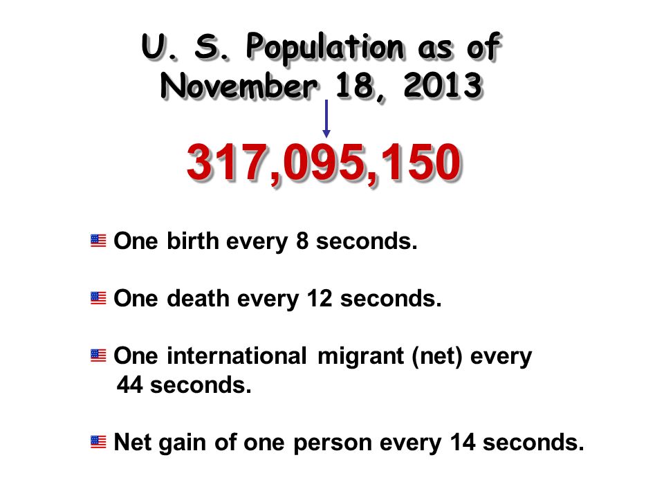
317,095,150317,095,150 One birth every 8 seconds. One death every 12 seconds. One international migrant (net) every 44 seconds. Net gain of one person every 14 seconds. U. S. Population as of November 18, 2013
 every 44 seconds. Net gain of one person every 14 seconds. U. S. Population as of November 18,")
49
Seismography Data: 1977-1997 Earthquakes!

50
Tornadoes Per Year: 1950-1997

51
Hurricane Camille: The Storm of the Century August 17, 1969 Category 5 Killed 412 people

53
National Parks

Similar presentations