Download presentation
Presentation is loading. Please wait.

1
Dr.-Ing. Jens Hartmann, Account Manager The complete Process of Census/Surveys Data Processing – Where GIS can assist! May 2008, Doha, Qatar

2
Agenda Introduction to Intergraph Benefits of GIS Nigeria Census Geoportal Why Intergraph?

3
Leading global provider of Spatial Information Management (SIM) solutions We deliver software and services that enable customers to manage and understand complex data through intelligent visual representations Governments and businesses in over 60 countries rely on our software and services Founded 1969 in Huntsville, Alabama/USA 3.500 Employees Revenue 2007: 725 Mio. US$ Operating EBITDA 2007: 144 Mio. US$ Intergraph Corporation

4
Census and GIS? Census data are spatial data in it‘s nature Geographic Information Systems (GIS) can collect, store, manage, analyse and reproduce spatial data GIS link a data value (e.g. census data sets) to a geographical feature (e.g. enumeration area). GIS technology integrates common database operations such as query and statistical analysis with the unique visualization and geographic analysis benefits offered by maps.* *Source: DevInfo Digital Mapping Technical Note
 can collect, store, manage, analyse and reproduce spatial data GIS link a data value (e.g. census data sets) to a geographical feature (e.g. enumeration area). GIS technology integrates common database operations such as query and statistical analysis with the unique visualization and geographic analysis benefits offered by maps.* *Source: DevInfo Digital Mapping Technical Note.")
5
The process steps of Census data processing Pre-Enumeration -Integration of existing paper maps -Integration of aerial or satellite imagery -Converting existing data to census data model -Updating existing data sets -Conduction planning and optimisation Enumeration - Conduction planning and optimisation - Progress review - Mobile data collection (GPS supported) Post-Enumeration - Geocoding of result sets - Data integrity checks - Systematic error analysis - Data dissemination (internally/public) - Spatially enable OLAP Analysis - Thematic Mapping - Advanced Spatial Analysis - Planning the next steps GI Systems bring benefit here and here
 Post-Enumeration - Geocoding of result sets - Data integrity checks - Systematic error analysis - Data dissemination (internally/public) - Spatially enable OLAP Analysis - Thematic Mapping - Advanced Spatial Analysis - Planning the next steps GI Systems bring benefit here and here")
6
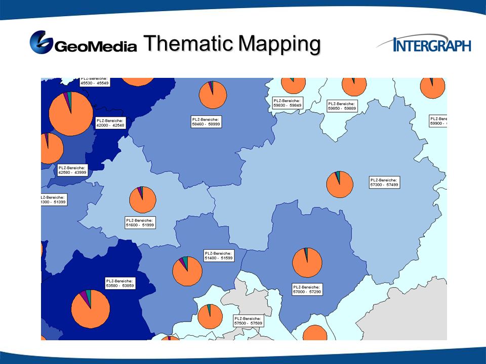
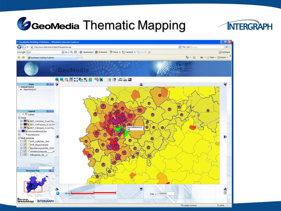
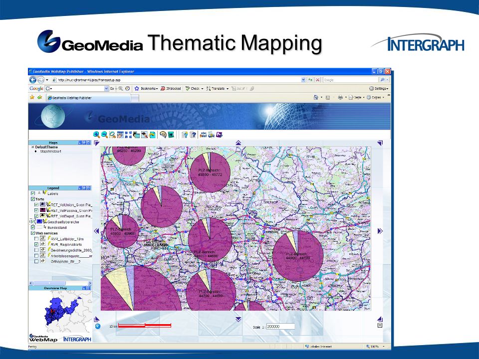
Thematic Mapping Thematic Mapping

10
Nigeria Census Geoportal National Population Commission of Nigeria (140 Mio (!) Inhabitants, Area 920.000 km²) “It has the statutory powers to collect, analyze and disseminate population/demographic data in the country” Last Census was conducted in 2006 Post-Enumeration Census activities are funded by EU
 Inhabitants, Area km²) It has the statutory powers to collect, analyze and disseminate population/demographic data in the country Last Census was conducted in 2006 Post-Enumeration Census activities are funded by EU")
11
Nigeria Census Geoportal Intergraph Tasks –Setting up spatially enable database (open integration with tabular census data provided by Beta Systems) –Process integration with Beta Systems Solution –Data migration of existing reference, topography data and satellite imagery –Data validation –Data documentation (metadata!) –Data dissemination by Geoportal (internally/Power User + public) –Absolutely standard driven (Open Geospatial Consortium (OGC) / Spatial Data Infrastructure (SDI))
 –Process integration with Beta Systems Solution –Data migration of existing reference, topography data and satellite imagery –Data validation –Data documentation (metadata!) –Data dissemination by Geoportal (internally/Power User + public) –Absolutely standard driven (Open Geospatial Consortium (OGC) / Spatial Data Infrastructure (SDI))")
12
Why Intergraph? Proven, highly scalable GIS platform GeoMedia Strength: data integration, validation, collection and analysis Compliant to IT and GIS standards (e.g. SOA, OGC) Leader in SDI technology Integration with DevInfo We are more than a software vendor, we are a solution company!
 Leader in SDI technology Integration with DevInfo We are more than a software vendor, we are a solution company!.")
13
Dr.-Ing. Jens Hartmann Account Manager Government Security, Government & Infrastructure Tel.+49 (0)89.96106.199 Fax+49 (0)89.96106.100 Mobil+49 (0)172.8315.394 jens.hartmann@intergraph.com Intergraph (Deutschland) GmbH Reichenbachstr. 3 85737 Ismaning Germany
 Fax+49 (0) Mobil+49 (0) Intergraph (Deutschland) GmbH Reichenbachstr Ismaning Germany.")
Similar presentations


, Namibia By Mrs Ottilie M Mwazi Chief Statistician, Survey, Cartography/GIS>")


 Fundamentals for Program Managers.>")


 as.>")
