Download presentation
Presentation is loading. Please wait.

1
By Andrew Y.T. Kudowor, Ph.D. www.geoinfoconsultants.com/andrewhome.html Lecture Presented at San Jacinto College

2
To accurately figure out where you are and where you're going is probably one of man's oldest pastimes. Navigation and positioning are crucial to so many activities and yet the process has always been quite cumbersome. Over the years all kinds of technologies have tried to simplify the task but every one has had some disadvantage. Finally, the U.S department of defense decided that the military had to have a super precise form of worldwide positioning. As a result the Global Positioning System was born, a system that's changed navigation forever.

3
Global Positioning Systems (GPS), is a worldwide radio- navigation system formed from a constellation of 24 satellites and their ground stations.
, is a worldwide radio- navigation system formed from a constellation of 24 satellites and their ground stations.")
4
The Space Segment Man-made stars (The 24 satellites) Each in its own orbit. User Segment Receivers (Hand or Mounted) Control Segment Five ground stations located around the world Control and monitor satellites for proper operation
 Control Segment Five ground stations located around the world Control and monitor satellites for proper operation.")
5
Data To and From Satellite RECEIVER (user segment) CONTROL STATION (control segment) Data from Satellite SATELLITES (space segment) Satellite ephemeris position constants Clock correction constants Atmospheric data Almanac Coded ranging signals Position information Atmospheric data Almanac
 CONTROL STATION (control segment) Data from Satellite SATELLITES (space segment) Satellite ephemeris position constants Clock correction constants Atmospheric data Almanac Coded ranging signals Position information Atmospheric data Almanac")
6
GPS nominal constellation 24 satellites in 6 orbital planes 4 satellites in each plane Orbiting the earth at 12600 miles at 55 degrees inclination

7
Each satellite is equipped with an accurate clock for broadcasting signals coupled with precise time message. The broadcast signals travel at the speed of light to the receivers. Satellites are positioned so that signals from 6 are available nearly 100% of the time.

8
5 GPS Master Control and Monitor Stations network Hawaii Monitor Station Master Control Monitor Station Falcon AFB Colorado Springs Ascension Island Monitor Station Diego Garcia Monitor Station Kwajalein Monitor Station

9
The monitors measure signals from the satellites which are incorporated into orbital models The models compute precise orbital data (ephemeris) and satellite clock corrections for each satellite. The master control station uploads ephemeris and clock data to the satellite. The satellites send subsets of the orbital ephemeris to GPS receivers through radio signals

10
Measurement of code-phase arrival from at least four satellites are used to estimate four quantities: position (X,Y,Z) and GPS time (t)
 and GPS time (t)")
11
GPS receivers can be hand carried or installed on aircraft, ships, tanks, cars, trucks, etc. Receivers detect, decode, and process the signals from the satellites. Four satellites are required to compute the four dimensions of X,Y,Z (position) and Time
 and Time.")
12
Five basic steps to understanding how GPS works. 1. “Triangulation/Trilateration" from satellites. 2. GPS receiver measures distance using the travel time of radio signals to Triangulation/Trilateration. 3. GPS needs very accurate timing to measure travel time. 4. Along with distance, you need to know exactly where the satellites are in space. 5. Correct for any delays the signal experiences as it travels through the atmosphere.

13
Position is calculated from accurate distance measurements (Pseudo- ranges) to satellites. Mathematically we need four satellite ranges to determine exact position.

14
The basics is, distance (range) is computed from velocity (V) and traveling time (T) using (D = VxT) Since we’re measuring a radio signal the velocity (V) is going to be the speed of light or roughly 186,000 miles per second. The travel time is computed from the delay ( t) in receiving the signal by the receiver. t = tR – tT tT – GPS Time of Transmission tR – Receiver Time of Reception
 in receiving the signal by the receiver. t = tR – tT tT – GPS Time of Transmission tR – Receiver Time of Reception.")
15
Time is determined by measuring how long a radio signal takes to reach us from that satellite. The time a radio signal takes to reach us from the satellite is computed from pseudo-random codes. Pseudo-random codes is complex pattern of digital code.

16
In time measurement we assume that both the satellite and receiver are generating the same pseudo-random codes at exactly the same time. Comparing how late the satellite's pseudo- random code appears compared to our receiver's code, we determine how long it took to reach us.

17
GPS satellite transmit two signals designated L1, L2, etc. GPS signal contains three different bits of info.: – Pseudorandom code (complex digital code). – Ephemeris data (orbital info). – Almanac data (positional information, current date and time).
. – Ephemeris data (orbital info). – Almanac data (positional information, current date and time)..")
18
Ionosphere and Troposphere Delay – Built-in models to partially correct this error Multipath Errors – Signal reflection off objects. Orbital Errors (Ephemeris Error) – Inaccuracy of the satellite’s reported location. Selective Availability (SA) – Intentional degradation of the satellite signal. Receiver Clock Error
 – Inaccuracy of the satellite’s reported location. Selective Availability (SA) – Intentional degradation of the satellite signal. Receiver Clock Error.")
19
Another factor that affects GPS accuracy is the geometry of the group of satellites from which signals are being received. An indicator of the quality of the geometry of the satellite constellation is known as dilution of precision (DOP).
..")
20
A greater angle between the satellites lowers the DOP, and provides a better measurement. A higher DOP indicates poor satellite geometry, and an inferior measurement configuration. Based upon the almanac info, some GPS receivers can choose those satellites with the best geometry in order to make the DOP as low as possible.

22
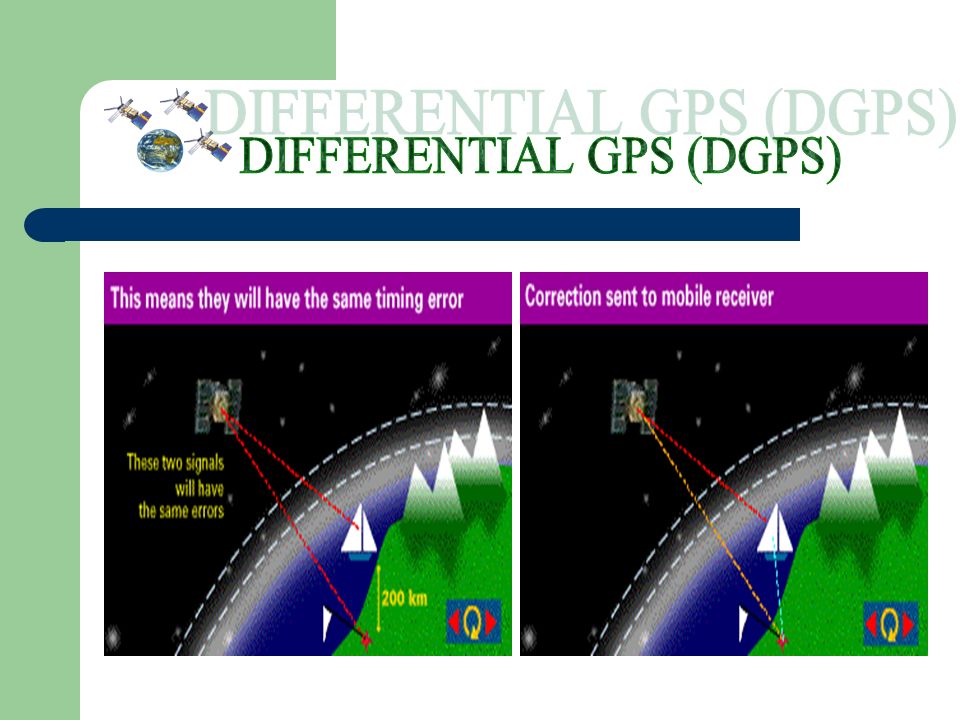
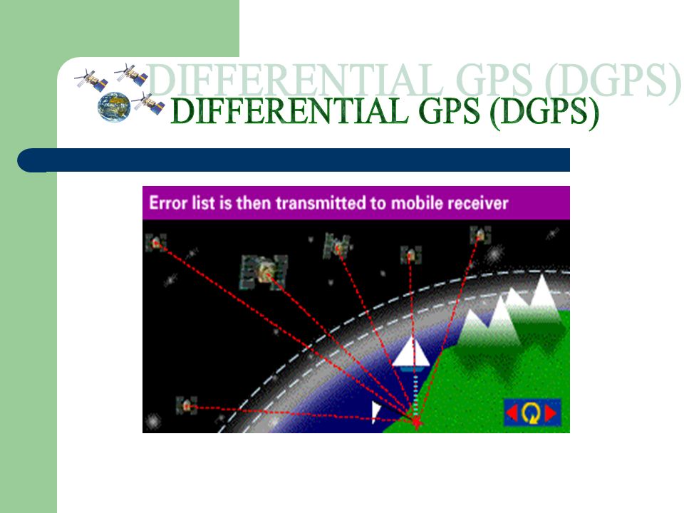
DGPS is used to improve the accuracy of standard GPS by eliminating GPS errors.

25
Three types of GPS receivers that offers different levels of accuracy. Coarse Acquisition (C/A) Code receivers. Carrier Phase Receivers. Dual-Frequency receivers
 Code receivers. Carrier Phase Receivers. Dual-Frequency receivers.")
26
Typically provide 1-5 meter GPS position accuracy with differential correction with occupation time of 1 second. Longer occupation times (up to 3 minutes) will provide accuracies consistently within 1- 3 meters. Recent advances in GPS receiver design now allow a C/A Code receiver to provide sub-meter accuracy, down to 30 cm.
 will provide accuracies consistently within 1- 3 meters. Recent advances in GPS receiver design now allow a C/A Code receiver to provide sub-meter accuracy, down to 30 cm..")
27
Typically provide 10-30 cm GPS position accuracy with differential correction. It measures the distance from the receiver to the satellites by counting the number of waves that carry the C/A Code. Signal Require a substantially higher occupation time to attain 10-30 cm accuracy. Requires Maintaining the same satellite constellation, performance under canopy and the need to be very close to a base station.

28
Capable of providing sub-centimeter GPS position accuracy with differential correction. Receives signals from the satellites on two frequencies simultaneously.

29
Location - determining a basic position. Navigation - getting from one location to another. Tracking - monitoring the movement of people and things. Mapping - creating maps of the world Timing - bringing precise timing to the world

30
References Trimble – A good GPS Tutorial siteA good GPS Tutorial site Garmin – GPS guide for BeginnersGPS guide for Beginners

Similar presentations


 Precise positioning service.>")


 for Precision Farming>")


. NAVSTAR Global Positioning System (GPS) Globally.>")

 P.JANANI(110051101051) R.JANOFER FERHANA(110051101052) KADIRIMANGALAM JAHNAVI(110051101055)>")

>")

