Download presentation
Presentation is loading. Please wait.

1
Measuring biodiversity Dr RJ (Bob) Scholes Chair, Global Terrestrial Observing System CSIR Environmentek PO Box 395, Pretoria 0001, South Africa bscholes@csir.co.za
 Scholes Chair, Global Terrestrial Observing System CSIR Environmentek PO Box 395, Pretoria 0001, South Africa")
2
This paper will cover… Theory of biodiversity observations Existing approaches and systems Approaches that may satisfy the goals

3
Biodiversity : 3 aspects x 3 levels (Noss 1994) Functional Structural Compositional Landscape patterns Landscape processes/ disturbances/ Population structure Physiognomy/ha bitat structure Landscape type Interspecifi c interactions Genetic structure Demographic process Species, populations Gene s Communities/ecosyst ems Genetic process
 Functional Structural Compositional Landscape patterns Landscape processes/ disturbances/ Population structure Physiognomy/ha bitat structure Landscape type Interspecifi c interactions Genetic structure Demographic process Species, populations Gene s Communities/ecosyst ems Genetic process")
4
At any level, diversity has at least two components… How many different types of things are present –Elephant, rhino and lion is less diverse than –Elephant, rhino, lion, leopard and buffalo How evenly they are represented –1000 elephants and 1 lion is less diverse than –500 elephants and 500 lions

5
‘Academic’ ways of measuring biodiversity Species level Richness: Total number of species in an area ( diversity) Species turnover along a gradient ( diversity) Ecosystem level Number of different habitats or ecosystems ( diversity) Genetic level Genetic homology Cladistic distance
 Species turnover along a gradient ( diversity) Ecosystem level Number of different habitats or ecosystems ( diversity) Genetic level Genetic homology Cladistic distance")
6
‘Policy’ ways of measuring biodiversity ‘Extinction based’ (IUCN) –Threatened species (Red Data Books) ‘Area based’ (Millennium goals) –Area under protection –Area of a key habitat (eg Forest cover) ‘Richness based’ –Indicator groups or species eg CI Rapid Biodiversity Assessment Complementarity –based –Various conservation optimisation tools, eg CPLAN Various spatial representations –Hotspots, last wild places
 –Threatened species (Red Data Books) ‘Area based’ (Millennium goals) –Area under protection –Area of a key habitat (eg Forest cover) ‘Richness based’ –Indicator groups or species eg CI Rapid Biodiversity Assessment Complementarity –based –Various conservation optimisation tools, eg CPLAN Various spatial representations –Hotspots, last wild places")
7
Royal Society Report 2003 ‘… no sound basis exists for assessing performance against these targets.’ ‘The fate of organisms not yet recognised by science cannot be measured’ Lack of baselines Biodiversity measures must be related to the objectives of measurement

8
Attributes of a good indicator Does it measure what it says it does? Sensitive, but not oversensitive Scale appropriate in time and space Well-understood model Reliable data available Monitoring systems in place Understandable by policymakers (NRC 2000)
.")
9
NCI = ecosystem quality x ecosystem quantity Natural Capital Index RIVM/UNEP-WCMC/GEO-3

10
Example: NCI for The Netherlands

11
SA MA * Biodiversity Intactness Index Based on impacts on populations, rather than extinctions Considers a range of impacts –Protected, sustainably used, unsust used, partially transformed, transformed Scale independent Applicable now, but amenable to incremental improvement Millennium Ecosystem Assessment Strengthening Capacity to Manage Ecosystems Sustainably for Human Well-Being * Southern Africa Millennium Ecosystem Assessment

12
SA MA Algorithm B = biodiversity intactness index C ijk = populations of i under use k/ popn when protected A jk = Area of land use k in ecosystem j R ij = Richness of taxon i in ecosystem j i= taxon, from 1 to t j= ecosystem, from 1 to m k= land use type, from 1 to n Needs: Land cover, richness, impact matrix

13
Worked example South Africa, biome resolution

14
WWF Ecoregion database 867 biodiversity-based regions of the world Based on best available information Species lists for birds, mammals, reptiles, plants,amphibia

15
Global land cover products Many are now available –DISCover, FAO-FRA, GLC 2000, Modis… Global coverage, resolution < 1 km –20 m products available for key areas Methods and results convergence –GOFC/GOLD (a GTOS panel) Mid 1990s baselines feasible, year 2000 baseline in hand Reliable expectation of year 2010 repeat
 Mid 1990s baselines feasible, year 2000 baseline in hand Reliable expectation of year 2010 repeat")
16
What GTOS can offer Global Terrestrial Observing System Biodiversity is one of the five mandated topics covered by GTOS –Land, freshwater, cryosphere –Close collaboration with GOOS on coasts –GOOS covers open ocean TEMS database –‘biodiversity module’ Biodiversity network: methods harmonised GOFC/GOLD –Land cover dynamics, especially forests

17
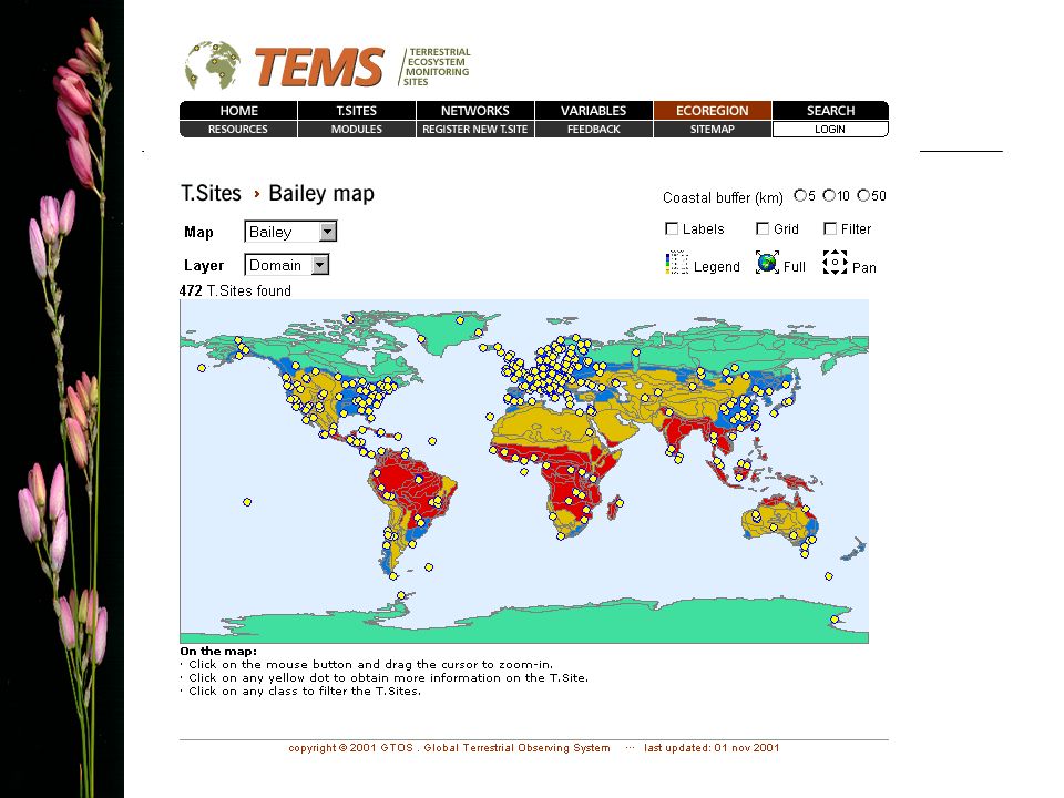
Who, what, where TEMS: Terrestrial Ecosystem Monitoring Sites Web directory of 1,600 sites and 55 networks in 110 countries that carry out long-term terrestrial ecosystem monitoring of 110 variables http://www.fao.org/gtos/tems

19
Variables specific to biodiversity: Colonization of habitat by invasive species Habitat conversion Habitat fragmentation Indicator species Pollinator species Species Richness Threatened Species Many of the other 115 variables in TEMS are also directly linked to Biodiversity. TEMS Biodiversity module

20
The CBD and WSSD goals CBD CoP VII/26, WSSD Implementation Plan ‘..significantly reduce the rate of loss of biodiversity by 2010…’ This is a ‘double differential’ problem –Change in a rate Requires at least 3 snapshots in time to solve Rate 1 201020001990 Biodiversity Rate 2 rate 2 < rate 1

21
Global strategy for plant conservation CBD CoP VI/9 April 2002 1.Accessible list of plant species… 2.Assess status of all species… 3.Understand conservation needs for threatened species… 4.10% of each ecological region, 50% of species conserved in situ 5.90% threatened species cons ex situ 6.30% of production lands managed consistent with conservation goals

22
UN Millennium Goals ‘…reverse the loss of environmental resources…’ Proposed indicators: –Proportion of land area covered by forest –Proportion of land area protected for biodiversity conservation These indicators are measurable, but not necessarily sensitive to the goal

23
Pragmatic issues… For the purpose of evaluating progress towards the goals, biodiversity measurements –Don’t have to be perfect, just agreed –Need to be based on ‘activity’ rather than ‘stock’ measurements (cf UNFCCC) –Satellite-based land cover measurements, coupled with ‘sparse’ in-situ information in an explicit way (a ‘model’) could do the job for terrestrial systems
 –Satellite-based land cover measurements, coupled with ‘sparse’ in-situ information in an explicit way (a ‘model’) could do the job for terrestrial systems")
24
A proposal Agree to develop an approach based on 1.Land cover/use in 1995, 2000, 2005 and 2100 [GOFC/GOLD + WCMC] 2.Richness within ecosystem units [WWF + Taxonomy initiatives+ NGOs + nations] 3.An impact matrix (land use x taxa, per biome) derived from site data, models and expert judgement [ Diversitas + GTOS] For test by 2005, and retrospective application by 2010
![A proposal Agree to develop an approach based on 1.Land cover/use in 1995, 2000, 2005 and 2100 [GOFC/GOLD + WCMC] 2.Richness within ecosystem units [WWF + Taxonomy initiatives+ NGOs + nations] 3.An impact matrix (land use x taxa, per biome) derived from site data, models and expert judgement [ Diversitas + GTOS] For test by 2005, and retrospective application by 2010](http://images.slideplayer.com/25/7904148/slides/slide_24.jpg "A proposal Agree to develop an approach based on 1.Land cover/use in 1995, 2000, 2005 and 2100 [GOFC/GOLD + WCMC] 2.Richness within ecosystem units [WWF + Taxonomy initiatives+ NGOs + nations] 3.An impact matrix (land use x taxa, per biome) derived from site data, models and expert judgement [ Diversitas + GTOS] For test by 2005, and retrospective application by 2010")
Similar presentations

>")


 Fish 458; Lecture 24.>")


