Download presentation
Presentation is loading. Please wait.

1
© Crown copyright Met Office 1 John Nash, 2 Catherine Gaffard, 2 Owen Cox, 1 Myles Turp, 1 Mark Smees, 1 Richard Smout and 1 Tim Oakley Upper Air (Active)Team, Observations Research and Development, 1 Exeter and 2 Reading Bridging the gap between research instrument development and operations, Radiosonde tests and integrated profiling testbeds, Achievements and challenges for CIMO
Team, Observations Research and Development, 1 Exeter and 2 Reading Bridging the gap between research instrument development and operations, Radiosonde tests and integrated profiling testbeds, Achievements and challenges for CIMO")
2
© Crown copyright Met Office Contents This presentation covers the following areas Introduction to CIMO Vision Radiosonde InterComparison results Testbed for integrated remotes sensing

3
© Crown copyright Met Office CIMO VISION CIMO will: pursue the effective and economic development, implementation and use of instruments for :- meteorological, climatological, hydrological, oceanic and related geophysical and environmental observations under varying working conditions and in differing technical infrastructures as required,,

4
© Crown copyright Met Office Expand the scope of CIMO to take into account the increasing requirements of the WMO Integrated Global Observing System Global Framework for Climate Services Disaster Risk Reduction and coordinate in development of instruments suitable to difficult climate and social environment,

5
© Crown copyright Met Office Coordinate the introduction of new technologies, Evaluate them by appropriate methods [e.g. intercomparisons or testbed operations] and provide advice to facilitate introduction into effective operational use, This is the primary challenge for ground based insitu and remote sensing of the atmosphere above the surface.

6
© Crown copyright Met Office For technical experts [Upper Air] Help national experts in different regions of the world to share experience, ideas and to identify areas where collaboration or contracted experts are required to take the work forward. Improve collaboration between research, development and operations and instrument manufacturers.
![© Crown copyright Met Office For technical experts [Upper Air] Help national experts in different regions of the world to share experience, ideas and to identify areas where collaboration or contracted experts are required to take the work forward.](http://images.slideplayer.com/25/7729738/slides/slide_6.jpg "Improve collaboration between research, development and operations and instrument manufacturers..")
7
© Crown copyright Met Office Develop, publish and provide effective access to : standards, reliable methods of observation suitable quality assurance methods, performance specifications issues associated with compatibility of instruments, interoperability between in situ and remotely sensed observations guidance material [e.g: WMO Guide to Meteorological Instruments and Methods of Observation] on instrumentation
![© Crown copyright Met Office Develop, publish and provide effective access to : standards, reliable methods of observation suitable quality assurance methods, performance specifications issues associated with compatibility of instruments, interoperability between in situ and remotely sensed observations guidance material [e.g: WMO Guide to Meteorological Instruments and Methods of Observation] on instrumentation](http://images.slideplayer.com/25/7729738/slides/slide_7.jpg "© Crown copyright Met Office Develop, publish and provide effective access to : standards, reliable methods of observation suitable quality assurance methods, performance specifications issues associated with compatibility of instruments, interoperability between in situ and remotely sensed observations guidance material [e.g: WMO Guide to Meteorological Instruments and Methods of Observation] on instrumentation")
8
© Crown copyright Met Office Radiosonde Comparisons Modern series of tests started in 1984 Computing technology rapidly becomes adequate for automated processing of radiosonde mesurements

9
© Crown copyright Met Office WMO Radiosonde Comparison Phase I, Beaufort Park. UK, June/July 1984

10
© Crown copyright Met Office Computer had extremely small working memory

11
© Crown copyright Met Office Dr. Seshadri and the Indian MkII Phase II, 1985

12
© Crown copyright Met Office Phase III, Dzhambul

13
© Crown copyright Met Office Radiosondes flown together, lifted by single balloon WMO GPS Radiosonde Comparison,June 2001, Alcantara, Brazil, Project leader Reinaldo da Silveira

14
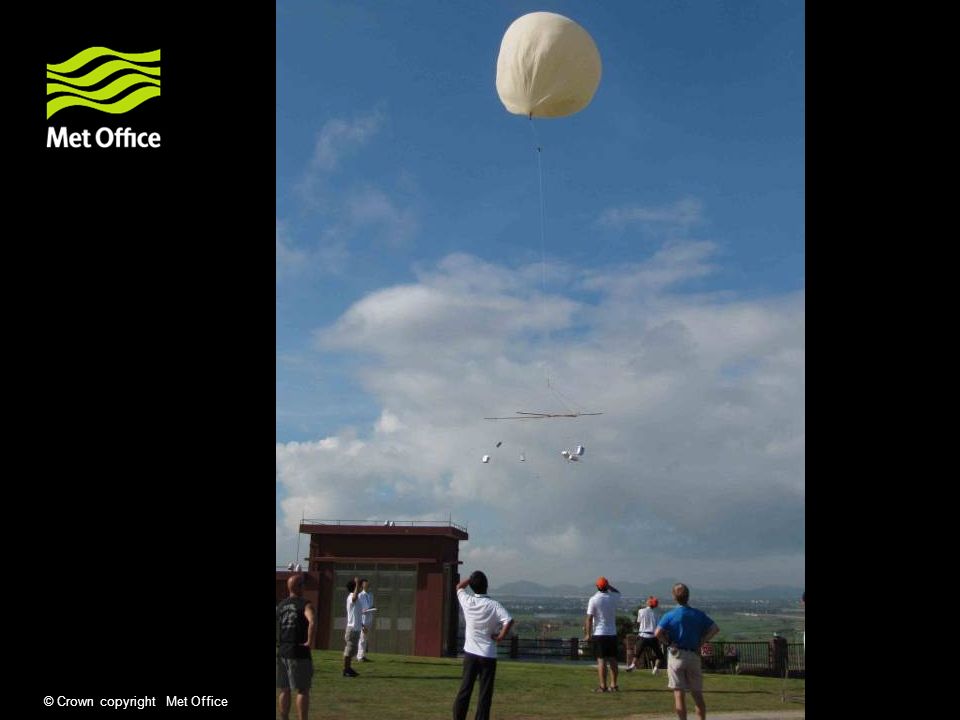
© Crown copyright Met Office Up to 20 local staff supporting operations at any time Mauritius, 2005

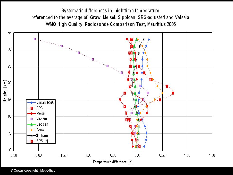
15
© Crown copyright Met Office

17
Effects of tests [i] Infrared temperature errors identified and largely eliminated from operational use. [ errors could be larger than daytime heating errors]. Impossible to obtain optimum performance with white paint on sensors. Temperature sensors should not be mounted in internal ducts. Data sampled at high temporal resolution in all automated systems around the world by about 2000. Faster response temperature sensors lead to smaller daytime heating if exposed carefully on the radiosonde.
![Effects of tests [i] Infrared temperature errors identified and largely eliminated from operational use.](http://images.slideplayer.com/25/7729738/slides/slide_17.jpg "[ errors could be larger than daytime heating errors]. Impossible to obtain optimum performance with white paint on sensors. Temperature sensors should not be mounted in internal ducts. Data sampled at high temporal resolution in all automated systems around the world by about Faster response temperature sensors lead to smaller daytime heating if exposed carefully on the radiosonde..")
18
© Crown copyright Met Office Rod thermistor measurements compared with tungsten wire(RS3) at night, asterisks, values estimated using RS80 as link radiosonde
 at night, asterisks, values estimated using RS80 as link radiosonde")
19
© Crown copyright Met Office

20
Other sensor measurements compared with tungsten wire(RS3) at night, asterisks, values estimated using RS80 as link radiosonde Bimetallic sensor in duct White thermistor in duct
 at night, asterisks, values estimated using RS80 as link radiosonde Bimetallic sensor in duct White thermistor in duct")
21
© Crown copyright Met Office

24
Effects of tests [ii] Goldbeater’s skin shown to be insensitive at temperatures lower than about -30 deg C. Carbon hygristors not stable after being exposed to high relative humidity, and insensitive at low relative humidity. Most sensors are now capacitative thin film polymers with differences in exposure varying from radiosonde to radiosonde type. Some humidity sensors now fast enough to measure reasonably well throughout the tropical troposphere[ Mauritius and Yangjiang], but some problems with contamination remain at upper levels.
![Effects of tests [ii] Goldbeater’s skin shown to be insensitive at temperatures lower than about -30 deg C.](http://images.slideplayer.com/25/7729738/slides/slide_24.jpg "Carbon hygristors not stable after being exposed to high relative humidity, and insensitive at low relative humidity. Most sensors are now capacitative thin film polymers with differences in exposure varying from radiosonde to radiosonde type. Some humidity sensors now fast enough to measure reasonably well throughout the tropical troposphere[ Mauritius and Yangjiang], but some problems with contamination remain at upper levels..")
25
© Crown copyright Met Office Simultaneous comparison between GBS (green), Hygristor (purple) and A- Humicap(blue), PREFRS, Crawley 1992 Height [km] Relative Humidity
![© Crown copyright Met Office Simultaneous comparison between GBS (green), Hygristor (purple) and A- Humicap(blue), PREFRS, Crawley 1992 Height [km] Relative Humidity](http://images.slideplayer.com/25/7729738/slides/slide_25.jpg "© Crown copyright Met Office Simultaneous comparison between GBS (green), Hygristor (purple) and A- Humicap(blue), PREFRS, Crawley 1992 Height [km] Relative Humidity")
26
© Crown copyright Met Office Height [km] RS80 H-Humicap
![© Crown copyright Met Office Height [km] RS80 H-Humicap](http://images.slideplayer.com/25/7729738/slides/slide_26.jpg "© Crown copyright Met Office Height [km] RS80 H-Humicap")
27
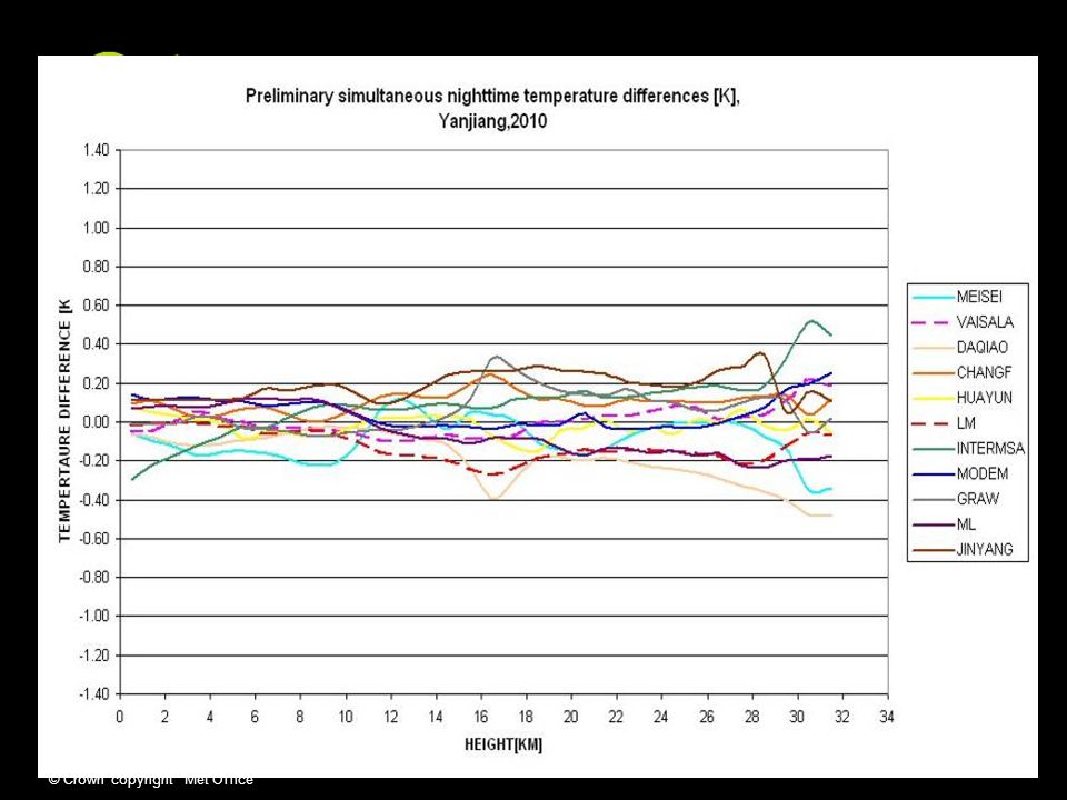
© Crown copyright Met Office Yangjiang, 2010

28
© Crown copyright Met Office Yangjiang, 2010

29
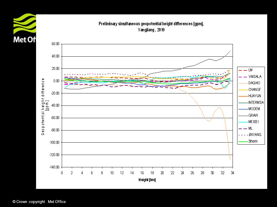
© Crown copyright Met Office Effects of tests [iii] Solutions to problems with early GPS radiosondes tested in Brazil Many pressure sensors had large systematic errors, and sometimes these changed as the methods of mounting in the radiosonde were altered, see RS80) In Mauritius, GPS heights are shown to be of high quality for the first time, so that the need for a pressure sensor is no longer essential for a GPS radiosonde. In Yangjiang, only one radiosonde used a pressure sensor to determine geopotential heights. Success depends on collaboration between manufacturers and WMO experts, results from Yangjiang will benefit from input from GRUAN scientists.
![© Crown copyright Met Office Effects of tests [iii] Solutions to problems with early GPS radiosondes tested in Brazil Many pressure sensors had large systematic errors, and sometimes these changed as the methods of mounting in the radiosonde were altered, see RS80) In Mauritius, GPS heights are shown to be of high quality for the first time, so that the need for a pressure sensor is no longer essential for a GPS radiosonde.](http://images.slideplayer.com/25/7729738/slides/slide_29.jpg "In Yangjiang, only one radiosonde used a pressure sensor to determine geopotential heights. Success depends on collaboration between manufacturers and WMO experts, results from Yangjiang will benefit from input from GRUAN scientists..")
30
© Crown copyright Met Office

32
Will we need more large scale intercomparisons? Requirement for regional comparison in Russia Results at Yangjiang will probably require some limited additional tests within 3 years to show that some of the problems identified have been addressed and rectified. Large scale test will require a host country and agreement between all parties, scientists, manufacturers and WMO experts that it is necessary and worth while In between national/regional tests need to be done to a high standard and results reported to the CIMO Expert team Results need to be based on statistical evaluation and not on the interpretation of individual test flights.

33
© Crown copyright Met Office Purpose of testbed Long term deployment of remote sensing systems or insitu systems to allow comprehensive testing and development of products/observations over a full range of atmospheric conditions. May be one test site with a large range of facilities, Or a more extended array of sites using a less expensive mixture of observing systems [FUND] or derivation of a product from existing systems such as laser ceilometers giving a wide area with realtively large numbers of observations. In Europe a range of testbeds are being considered in the Eg- CLIMET COST project [ Prof. Illingworth will talk about this]

34
© Crown copyright Met Office Next Generation UK Upper-Air Network Needed to meet User Requirements. (i.e. Higher spatial and temporal resolution ) for high resolution model (1.5km grid) for winds, temperature, humidity, cloud profile Resolve structures of mesoscale storms on a scale of less than 100 km
 for high resolution model (1.5km grid) for winds, temperature, humidity, cloud profile Resolve structures of mesoscale storms on a scale of less than 100 km.")
35
© Crown copyright Met Office FUND testbed Testing of assimilation of new observations into numerical weather prediction models will be concentrated around London, based on wind profiler observations + other sensors [integrated profiling systems ] at Chilbolton, Wattisham and Cardington Further Development of remote sensing hardware will be done near Exeter. More aircraft observations from the airports shown for 2010 are expected before too long, once contractual arrangements for delivery of data have been sorted out.
![© Crown copyright Met Office FUND testbed Testing of assimilation of new observations into numerical weather prediction models will be concentrated around London, based on wind profiler observations + other sensors [integrated profiling systems ] at Chilbolton, Wattisham and Cardington Further Development of remote sensing hardware will be done near Exeter.](http://images.slideplayer.com/25/7729738/slides/slide_35.jpg "More aircraft observations from the airports shown for 2010 are expected before too long, once contractual arrangements for delivery of data have been sorted out..")
36
© Crown copyright Met Office Chilbolton Wattisham Herstmonceux Cardington Dunkeswell Cobbacombe Cross Dean Hill Clee Hill Chenies Thurnham Airport observations By 2010 Wind Profiler +radiometer Wind Profiler 2010

37
© Crown copyright Met Office Met Office Chilbolton installation

38
© Crown copyright Met Office Development tasks for assimilation of Integrated profiling products classification target type ( follow CLOUDNET but add clear air) atmospheric structure [stability] quality control Deal with non-CLOUDNET measurements [e.g.microwave radiances] and associated forward operators comparison with model equivalent
![© Crown copyright Met Office Development tasks for assimilation of Integrated profiling products classification target type ( follow CLOUDNET but add clear air) atmospheric structure [stability] quality control Deal with non-CLOUDNET measurements [e.g.microwave radiances] and associated forward operators comparison with model equivalent](http://images.slideplayer.com/25/7729738/slides/slide_38.jpg "© Crown copyright Met Office Development tasks for assimilation of Integrated profiling products classification target type ( follow CLOUDNET but add clear air) atmospheric structure [stability] quality control Deal with non-CLOUDNET measurements [e.g.microwave radiances] and associated forward operators comparison with model equivalent")
39
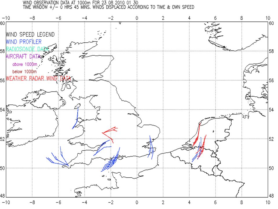
© Crown copyright Met Office How can the UK testbed inform user decisions? Dense network needed by users, but how dense is required given the chance to exploit high time-res 4DVAR assimilation techniques? FUND testbed can have higher observation density than is affordable normally, because of the high number of airports near London Testbed can be run continuously, so important meteorological events are not missed [ example shown is a rapidly deepening depression in late August 2010] Chilbolton site allows evaluation of full integrated profiling, and three other sites will also be used for cheaper variants of the full system Integrated network in plan view necessary for evaluations © Crown copyright Met Office

40
00.00 UTC, 23.08.10 x

41
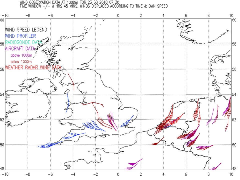
© Crown copyright Met Office 06.00 UTC, 23.08.10

42
© Crown copyright Met Office x

46
x

48
8 km Heavy rain forecast,but movement of depression not exact. Dunkeswell 22/23 August 2010

49
© Crown copyright Met Office Some Wind profiler issues[i] Why are no efforts made to check between high mode [low vertical resolution] and low mode [high vertical resolution? And no effort to influence users to use the most reliable product in a given situation?
![© Crown copyright Met Office Some Wind profiler issues[i] Why are no efforts made to check between high mode [low vertical resolution] and low mode [high vertical resolution.](http://images.slideplayer.com/25/7729738/slides/slide_49.jpg "And no effort to influence users to use the most reliable product in a given situation .")
50
© Crown copyright Met Office U, Low mode, vertical resolution 75m

51
© Crown copyright Met Office U, High mode Better signal to noise, but vertical resolution 375m Does not resolve shear under the low level wind maximum

52
© Crown copyright Met Office Examples of potential usefulness of additional wind profiler observations in integration are as follows: vertical velocity (most of the time ) sampled at one minute temporal resolution height of significant levels or lid (most of the time)+ Identification of top of convective boundary layer from signal to noise, vertical velocity,spectral width? {+laser ceilometer and cloud radar }

53
© Crown copyright Met Office Halo Photonics lidar, Chilbolton

54
© Crown copyright Met Office W ms -1, Wind profiler radar about 600 m from the lidar Continuous vertical velocity measurements

55
© Crown copyright Met Office Mixture of what is happening overhead with what is advected over the site, purple dots main updrafts

56
© Crown copyright Met Office Using variance in vertical velocity measurements as an indicator for the stability of the boundary layer

57
© Crown copyright Met Office Wind profiler Snrdir2 Dark blue -5 red 35

58
© Crown copyright Met Office 2000m Raw Jenoptik CHM Lidar

59
© Crown copyright Met Office RMS of w m.s -1, twenty minute periods, Chilbolton wind profiler,17.05.10

60
© Crown copyright Met Office Some Wind profiler issues[ii] Why is there no recognition that integrated profiling needs time stamped observations from the wind profiler to be processed together with data from other observing systems, not on the wind profiler ground station ? How are data to be supplied when horizontal winds require sampling over 15 or 30 minutes, [depending on meteorological circumstances], whereas vertical velocity and backscattered power need reporting with much higher temporal resolution?
![© Crown copyright Met Office Some Wind profiler issues[ii] Why is there no recognition that integrated profiling needs time stamped observations from the wind profiler to be processed together with data from other observing systems, not on the wind profiler ground station .](http://images.slideplayer.com/25/7729738/slides/slide_60.jpg "How are data to be supplied when horizontal winds require sampling over 15 or 30 minutes, [depending on meteorological circumstances], whereas vertical velocity and backscattered power need reporting with much higher temporal resolution .")
61
© Crown copyright Met Office

63
94GHz FMCW cloud radar

64
© Crown copyright Met Office Jenoptik CHM Lidar

65
© Crown copyright Met Office Does co-ordination exist? Good working relationships have been established with HMEI, and been renewed through working together on :- Radiosonde testing Training workshops for upper air measurements Documentation. To some extent, through co-ordination with GCOS scientists in developing GCOS Reference Upper Air Network. It is hoped that working together on testbed results and evaluations will bring in a wider range of experts.

66
© Crown copyright Met Office Questions and answers

67
© Crown copyright Met Office Gradient of the potential refractive index computed from the hourly radiosonde profile (dn/dz)^2 Wind profiler SNR, +cloud base from ceilometer ( white circle) Why does cloud top have higher signal to noise than the lid [1.2 km] at similar heights earlier in the day?
![© Crown copyright Met Office Gradient of the potential refractive index computed from the hourly radiosonde profile (dn/dz)^2 Wind profiler SNR, +cloud base from ceilometer ( white circle) Why does cloud top have higher signal to noise than the lid [1.2 km] at similar heights earlier in the day](http://images.slideplayer.com/25/7729738/slides/slide_67.jpg "© Crown copyright Met Office Gradient of the potential refractive index computed from the hourly radiosonde profile (dn/dz)^2 Wind profiler SNR, +cloud base from ceilometer ( white circle) Why does cloud top have higher signal to noise than the lid [1.2 km] at similar heights earlier in the day")
68
© Crown copyright Met Office 25.08.05 MCS system in relatively cold air.shows boundary layer collapses with cold pool generated behind both showers

69
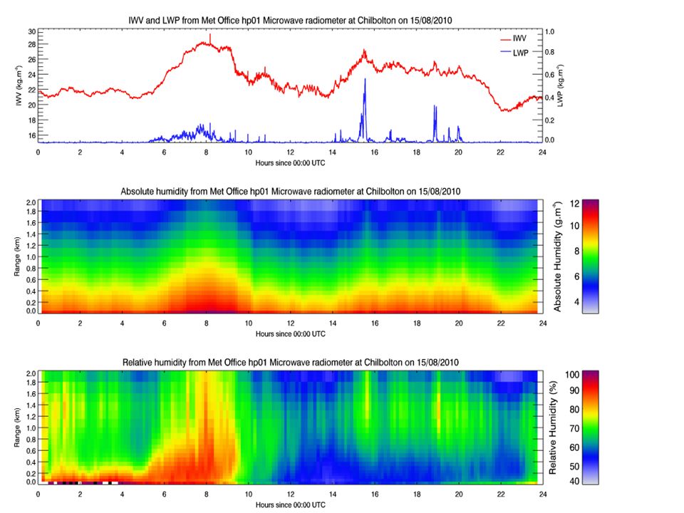
© Crown copyright Met Office Microwave measurement

70
© Crown copyright Met Office Future UK Upper Air requirements? An interpretation of user review, but needs further examination.

71
© Crown copyright Met Office

72
Data to be used in integrated profiling development will come from at least 6 sites in the UK including the SE testbed network, see next slide.] with different mixtures of remote sensing data Aberystwyth Camborne Cardington Chilbolton Hesrtmonceux Wattisham
![Data to be used in integrated profiling development will come from at least 6 sites in the UK including the SE testbed network, see next slide.] with different mixtures of remote sensing data Aberystwyth Camborne Cardington Chilbolton Hesrtmonceux Wattisham](http://images.slideplayer.com/25/7729738/slides/slide_72.jpg "Data to be used in integrated profiling development will come from at least 6 sites in the UK including the SE testbed network, see next slide.] with different mixtures of remote sensing data Aberystwyth Camborne Cardington Chilbolton Hesrtmonceux Wattisham")
73
© Crown copyright Met Office WMO Radiosonde Comparisons Fly radiosondes side by side so all meteorological variables can be compared at the same time, separating height assignment differences from temperature, relative humidity and pressure sensor differences All data handed in very quickly once test flight is completed and thoroughly checked so that data are not normally altered once the field phase of the test is complete. Poor performance in test has to be corrected subsequently or may lead to the death of the radiosonde design.

74
© Crown copyright Met Office GRUAN Observing strategy?? Use at least two different systems at highest quality reference site, to guard against changes in performance induced by production engineering changes. Only perform twinflight comparisons, if significant differences occur between the two types of radiosonde. The use of specialised radiosonde [scientific sounding instrument] must be well documented, health and safety issues and environmental impact should be taken into account.

75
© Crown copyright Met Office This change in PCB design did affect the performance of the Vaisala RS80 pressure sensor

Similar presentations


![Page 1© Crown copyright 2004 Introduction to upper air measurements with radiosondes and other in situ observing systems [2] Factors affecting comparisons.](/7/1708880/big_thumb.jpg "Page 1© Crown copyright 2004 Introduction to upper air measurements with radiosondes and other in situ observing systems [2] Factors affecting comparisons.>")
 WMO ET-UASI, Payerne June 2008, Agenda Item 3.4.>")
![Page 1© Crown copyright 2004 Introduction to upper air measurements with radiosondes and other in situ observing systems [3] John Nash, C. Gaffard,R. Smout.](/9/2485354/big_thumb.jpg "Page 1© Crown copyright 2004 Introduction to upper air measurements with radiosondes and other in situ observing systems [3] John Nash, C. Gaffard,R. Smout.>")


>")


