Download presentation
Presentation is loading. Please wait.

1
September 18, 2008 I-35 South Environmental Assessment North End of I-35 SH 9W Interchange Ramps North to ½ Mile North of Main Street in Norman Public Meeting

2
ODOT Benham FHWA I-35 South Environmental Assessment Introductions

3
I-35 South Environmental Assessment Project Team

4
Meeting Purpose I-35 South Environmental Assessment Provide Project Status Update – Results of Environmental Data Collection & Evaluation to Date – Interchange Alternatives for Main Street, Lindsey Street, and SH 9 East & Associated Traffic Analyses Obtain Input / Feedback

5
I-35 South Environmental Assessment Study Area

6
Expand I-35 to 6 Lanes North of Canadian River Bridge Reconstruct SH 9E, Lindsey, & Main Interchanges I-35 South Environmental Assessment Proposed Improvements

7
Establish Project within ODOT Complete Environmental Process Design Project Acquire Right-of-Way Relocate Utilities Construct Project I-35 South Environmental Assessment The Roadway Improvement Process

8
National Environmental Policy Act Decision Making Process I-35 South Environmental Assessment NEPA Process

9
Minimize Social, Environmental, & Economic Impacts of the Project Solicit Input from Federal, Tribal, State, Local Agencies, & Public Collect Environmental Data Estimate Construction, Right-of-Way, & Utility Costs Evaluate Data & Costs to Select Preferred Improvements I-35 South Environmental Assessment NEPA Process

10
Purpose & Need for Project Alternatives Affected Environment Possible Environmental Consequences Comments & Coordination / Public Involvement Engineering / Design / Drainage Concerns Accidents / Safety Concerns I-35 South Environmental Assessment Items Considered During Project Development

11
Increase Safety Provide Additional Capacity Existing ADTFuture ADT I-35 72,400 100,600 SH 9E 29,500 42,700 Main 42,600 55,200 Lindsey 27,300 36,800 Implement OCART Study Recommendations I-35 South Environmental Assessment Project Purpose & Need

12
I-35 South Environmental Assessment Interchange Alternatives

13
Existing I-35 SH 9 to Main Street

14
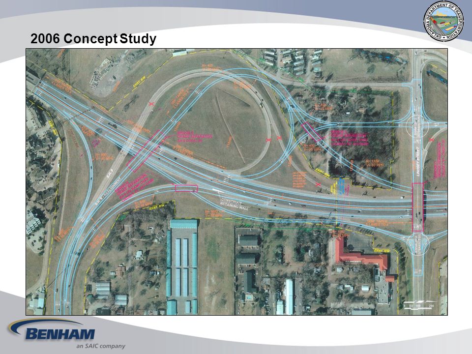
LOS = D/E LOS = C/F 2006 Concept Study

21
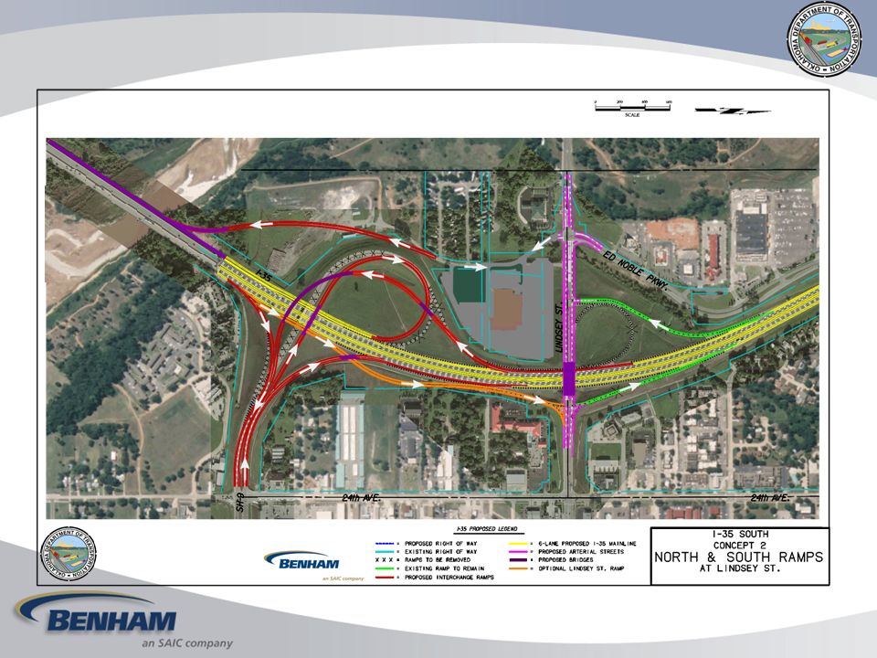
BRIDGE ADDITION SOUTH RAMPS AT LINDSEY STREET BRIDGE ADDITION NO SOUTH RAMPS AT LINDSEY STREET CONCEPT 2 CONCEPT 1 CONCEPT 2

22
1st Public MeetingSeptember 24, 2007 2nd Public Meeting September 18, 2008 Public HearingLate 2008 I-35 South Environmental Assessment Public Participation Opportunities

23
Web Address: http://www.okladot.state.ok.us/meetings/index.htm Scott Stegmann – ODOT Phone: 405.522.8014 200 NE 21st Street Oklahoma City, OK 73105 E-mail: sstegmann@ODOT.org Diane Abernathy – Benham Phone: 405.701.3167 3700 W. Robinson, Ste. 200 Norman, OK 73072 E-mail: diane.abernathy@benham.com I-35 South Environmental Assessment Information Sources

24
We Want Your Comments! I-35 South Environmental Assessment

25
Thank you! Questions & Answers

Similar presentations


17 CN 2357 Navajo 9 to Sheep Springs (NM 134) MP 15 to MP 46 Public Information Meeting November 1, 2006.>")


 )Project Community Advisory Committee October 3, 2007 Workshop.>")


 Jackson TSC Jackson County Jackson County Hillsdale County Hillsdale County.>")