Download presentation
Presentation is loading. Please wait.

1
Synoptic-Scale Conditions Leading to Flooding in South Carolina: A Case Study of October 22-23, 1990 (www.treehugger.com) Erik D. Kabela Joanne Stevenson Mini Tech 2009

2
Objectives Illustrate the effects on society (public/private property damage, evacuations, loss of life, etc) of this event. Link Maddox's (1979)* definition of a synoptic flash flooding event with October 22-23, 1990 event – Determine which of the 5 heavy rain event set-ups identified by Konrad (1997)** fits with this event Enhance the understanding and application of pattern recognition in heavy rain and flood forecasting *Maddox, R. A., Chappell, C. F. and L. R. Hoxit, 1979. Synoptic and Meso-α Scale Aspects of Flash Flood Events. Bull. of the Amer. Meteor. Soc., 60 (2), 115-123. **Konrad II, C. E., 1997. Synoptic-Scale Features Associated with Warm Season Heavy Rainfall over the Interior Southeastern United States. Wea. Forcasting, 12, 557- 571.
* definition of a synoptic flash flooding event with October 22-23, 1990 event – Determine which of the 5 heavy rain event set-ups identified by Konrad (1997)** fits with this event Enhance the understanding and application of pattern recognition in heavy rain and flood forecasting *Maddox, R. A., Chappell, C. F. and L. R. Hoxit, Synoptic and Meso-α Scale Aspects of Flash Flood Events. Bull. of the Amer. Meteor. Soc., 60 (2), **Konrad II, C. E., Synoptic-Scale Features Associated with Warm Season Heavy Rainfall over the Interior Southeastern United States. Wea. Forcasting, 12,")
3
Methods Archives The State, Greenville News, Aiken County Standard, The New York Times SHELDUS Web interfaces: NCDC - NOMADS Plymouth State University -Plot generation interface NOAA - National Severe Storms Laboratory NOAA – Daily Weather Maps USGS – Water Resources Data (Maddox et al., 1979)
")
4
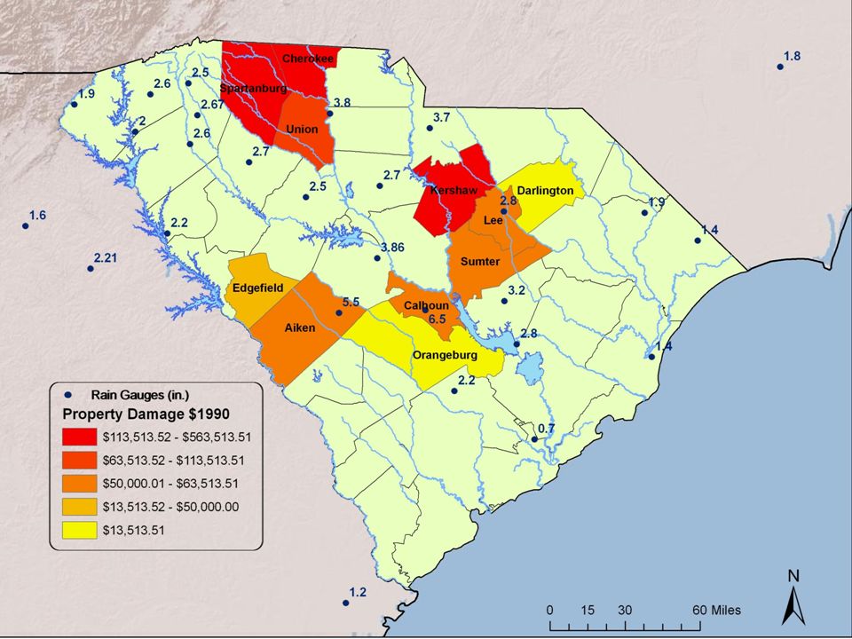
Flooding Impacts SC hit by disintegrating Hurricane Klaus and Tropical Storm Marco (Oct. 8-14) Up to 15 of rain Damage of $3-8 million, several thousand evacuations, 120 dam failures, 5 deaths Cold front moved through (Oct.22) Day and a half of nearly continuous rainfall on already stressed hydro system 11 counties receive Presidential Disaster Declarations (PDDs) >1,400 registrations for temporary housing, recovery of lost property, or repairs >$10 m of aid administered by federal government (NOAA,http://www.hpc.ncep.noaa.gov/tropical/rain/mar coklaus1990.html)
 Up to 15 of rain Damage of $3-8 million, several thousand evacuations, 120 dam failures, 5 deaths Cold front moved through (Oct.22) Day and a half of nearly continuous rainfall on already stressed hydro system 11 counties receive Presidential Disaster Declarations (PDDs) >1,400 registrations for temporary housing, recovery of lost property, or repairs >$10 m of aid administered by federal government (NOAA, coklaus1990.html).")
6
Pre-Exisiting Conditions Flood Stage

7
Heavy Rain/Flood Definition According to Konrad (1997) – At least 2 inches in a 6 hour period Break in between hourly precipitation could not exceed 2 hours
 – At least 2 inches in a 6 hour period Break in between hourly precipitation could not exceed 2 hours")
8
36-Hour Total Precipitation

9
Components of a Maddox Synoptic- Type Flood Event Quasi-stationary or slow moving weak cold front Ample low-level moisture – Usually greater than 60°F surface dew point 500mb strong short-wave trough Ample mid-level moisture – Dew point depression of <= 6°C

10
Surface Map – Oct. 22, 1990

11
500mb – Oct. 22, 1990

12
Maddox Ideal vs. Oct 23 00Z Surface Map Td = 70

13
Maddox Ideal vs. Oct 23 00Z 500mb Map

14
Comparison to Konrad – Type 2 Key Contributions Include: Slow moving cold front – Type 2 typically occurs during the transition season Ample low- and mid-level moisture Low-level convergence – Located NW of heavy rain Upper-level divergence Strong 500mb Vorticity Max Strong mean 850-200mb winds (>21 m/s) from the SW Strong instability using the K-Index 850mb warm-air advection Rain cells develop in echo train pattern
 from the SW Strong instability using the K-Index 850mb warm-air advection Rain cells develop in echo train pattern")
15
Ample Mid and Low-Level Moisture 700Mb mixing ratio of greater than 7 g/kg Surface precipitable water of greater than 1.5 inches (38.1 mm)
")
16
Low-level Convergence Low-level convergence max to the NW of the heavy precipitation

17
200mb Divergence Upper-level divergence promotes upward motion Heavy Rain area located over the left exit region of jet

18
500mb Vorticity Maximum Heavy rain located to the right of vorticity max

19
850 – 200mb Winds Mean 850 to 200mb winds blowing parallel to surface boundary Mean 850 to 200mb wind speed 24m/s

20
Instability with the K-Index K-Index between 28 and 32 – Corresponds to roughly 40- 60% chance of showers and thunderstorms

21
850mb Warm-Air Advection 850mb WWA promotes low- level rising motion

23
Conclusions Pre-existing stream conditions lead to increased potential for flooding on Oct 22-23 Flooding event of Oct. 22-23, 1990 fits classification of Maddox synoptic-type flood Flooding event further broken down into a Konrad Pattern 2 heavy rain event Provides a basis for using climatological studies for use in everyday forecasting Can prove useful for operational forecasters as well as emergency managers

Similar presentations

 and its Application to Flash Flood Forecasting in the Hawaiian Islands Kevin Kodama and Robert Ballard NOAA/NWS Honolulu.>")


 C Asia Air Survey co., ltd New Forecast Technologies for Disaster Prevention and Mitigation 1.>")
 National.>")
>")


: 37 Limit of wind speed (knots): 34 - 40 Description: Gale Sea State: Very Rough - High.>")


