Download presentation
Presentation is loading. Please wait.

1
La Cumbre Vieja By Alex, Chris, and Yang

2
The disaster A future volcanic eruption in the Canary Islands will cause a massive slab of rock breaking away from the island of La Palma and smash into the Atlantic Ocean, resulting a tsunami - a monster wave - bigger than any record. Most of the wave's energy would travel westwards to the American coast to cause catastrophic coastal damage. A future volcanic eruption in the Canary Islands will cause a massive slab of rock breaking away from the island of La Palma and smash into the Atlantic Ocean, resulting a tsunami - a monster wave - bigger than any record. Most of the wave's energy would travel westwards to the American coast to cause catastrophic coastal damage.

3
Canary Islands Canary Islands and volcanoes. Map based on Neumann van Padang and others (1967). Volcanism in the region is largely caused by hotspots in oceanic crust, and the region has the highest proportion of fissure vent volcanoes (as primary features). Several known volcanoes lie along or near the Mid- Atlantic Ridge that separates the Eurasian and African plates from the North and South American plates,hotspots Canary Islands and volcanoes. Map based on Neumann van Padang and others (1967). Volcanism in the region is largely caused by hotspots in oceanic crust, and the region has the highest proportion of fissure vent volcanoes (as primary features). Several known volcanoes lie along or near the Mid- Atlantic Ridge that separates the Eurasian and African plates from the North and South American plates,hotspots
. Several known volcanoes lie along or near the Mid- Atlantic Ridge that separates the Eurasian and African plates from the North and South American plates,hotspots Canary Islands and volcanoes. Map based on Neumann van Padang and others (1967). Volcanism in the region is largely caused by hotspots in oceanic crust, and the region has the highest proportion of fissure vent volcanoes (as primary features). Several known volcanoes lie along or near the Mid- Atlantic Ridge that separates the Eurasian and African plates from the North and South American plates,hotspots.")
4
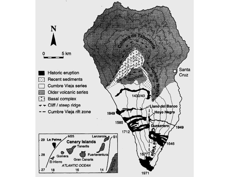
Island La Palma Location: 28.6N, 17.9W Elevation: 7,957 feet (2,426 m) Simplified geology of La Palma. Thick gray dashed line shows the location of a rift zone proposed by Carracedo (1994). Taburiente and Cumbre Nueva are calderas. The landward scarps of these calderas may mark the headwalls of giant landslides. Location: 28.6N, 17.9W Elevation: 7,957 feet (2,426 m) Simplified geology of La Palma. Thick gray dashed line shows the location of a rift zone proposed by Carracedo (1994). Taburiente and Cumbre Nueva are calderas. The landward scarps of these calderas may mark the headwalls of giant landslides.
. Taburiente and Cumbre Nueva are calderas. The landward scarps of these calderas may mark the headwalls of giant landslides. Location: 28.6N, 17.9W Elevation: 7,957 feet (2,426 m) Simplified geology of La Palma. Thick gray dashed line shows the location of a rift zone proposed by Carracedo (1994). Taburiente and Cumbre Nueva are calderas. The landward scarps of these calderas may mark the headwalls of giant landslides..")
5
La Palma is a stratovolcano, and is the largest of the western Canary Islands. Two main rock layers separated by a line about 1400 feet (427 m) above sea level make up La Palma. The lower layer is made of pillow lavas cut by basaltic dikes. The thickness of the pillow lavas range from 33 to 1150 ft (10 to 350 m). Most of the dikes are located within ~2 miles (3 km) of the west coast. The upper layer consists of basaltic lavas and pyroclastic rocks. Small alkalic domes have pushed their way into this area. Strong erosion of the island over time is shown by hundreds of meters of gravel mixed in with basaltic lava flows. The oldest volcanic rocks on La Palma are about 3-4 million years of age.stratovolcanopillow lavas pyroclastic La Palma has seven historic eruptions, the most recent in 1971 from the Teneguia vent. Other vents formed in historic time include Tahuya, a cone of lapilli, scoria and bombs about 3,000 feet tall (1,000 m) tall that formed over a three month period in 1585 by Strombolian eruptions and San Martin, a cone and crater that formed over two and a half months in 1646. The eruption at San Martin produced large amounts of lapilli and also sent four lava flows down to the ocean. Recent craters and eruptive vents are located along a central line. A large canyon drains the calderas to the southwest.calderas La Palma is a stratovolcano, and is the largest of the western Canary Islands. Two main rock layers separated by a line about 1400 feet (427 m) above sea level make up La Palma. The lower layer is made of pillow lavas cut by basaltic dikes. The thickness of the pillow lavas range from 33 to 1150 ft (10 to 350 m). Most of the dikes are located within ~2 miles (3 km) of the west coast. The upper layer consists of basaltic lavas and pyroclastic rocks. Small alkalic domes have pushed their way into this area. Strong erosion of the island over time is shown by hundreds of meters of gravel mixed in with basaltic lava flows. The oldest volcanic rocks on La Palma are about 3-4 million years of age.stratovolcanopillow lavas pyroclastic La Palma has seven historic eruptions, the most recent in 1971 from the Teneguia vent. Other vents formed in historic time include Tahuya, a cone of lapilli, scoria and bombs about 3,000 feet tall (1,000 m) tall that formed over a three month period in 1585 by Strombolian eruptions and San Martin, a cone and crater that formed over two and a half months in 1646. The eruption at San Martin produced large amounts of lapilli and also sent four lava flows down to the ocean. Recent craters and eruptive vents are located along a central line. A large canyon drains the calderas to the southwest.calderas
 above sea level make up La Palma. The lower layer is made of pillow lavas cut by basaltic dikes. The thickness of the pillow lavas range from 33 to 1150 ft (10 to 350 m). Most of the dikes are located within ~2 miles (3 km) of the west coast. The upper layer consists of basaltic lavas and pyroclastic rocks. Small alkalic domes have pushed their way into this area. Strong erosion of the island over time is shown by hundreds of meters of gravel mixed in with basaltic lava flows. The oldest volcanic rocks on La Palma are about 3-4 million years of age.stratovolcanopillow lavas pyroclastic La Palma has seven historic eruptions, the most recent in 1971 from the Teneguia vent. Other vents formed in historic time include Tahuya, a cone of lapilli, scoria and bombs about 3,000 feet tall (1,000 m) tall that formed over a three month period in 1585 by Strombolian eruptions and San Martin, a cone and crater that formed over two and a half months in The eruption at San Martin produced large amounts of lapilli and also sent four lava flows down to the ocean. Recent craters and eruptive vents are located along a central line. A large canyon drains the calderas to the southwest.calderas La Palma is a stratovolcano, and is the largest of the western Canary Islands. Two main rock layers separated by a line about 1400 feet (427 m) above sea level make up La Palma. The lower layer is made of pillow lavas cut by basaltic dikes. The thickness of the pillow lavas range from 33 to 1150 ft (10 to 350 m). Most of the dikes are located within ~2 miles (3 km) of the west coast. The upper layer consists of basaltic lavas and pyroclastic rocks. Small alkalic domes have pushed their way into this area. Strong erosion of the island over time is shown by hundreds of meters of gravel mixed in with basaltic lava flows. The oldest volcanic rocks on La Palma are about 3-4 million years of age.stratovolcanopillow lavas pyroclastic La Palma has seven historic eruptions, the most recent in 1971 from the Teneguia vent. Other vents formed in historic time include Tahuya, a cone of lapilli, scoria and bombs about 3,000 feet tall (1,000 m) tall that formed over a three month period in 1585 by Strombolian eruptions and San Martin, a cone and crater that formed over two and a half months in The eruption at San Martin produced large amounts of lapilli and also sent four lava flows down to the ocean. Recent craters and eruptive vents are located along a central line. A large canyon drains the calderas to the southwest.calderas.")
6
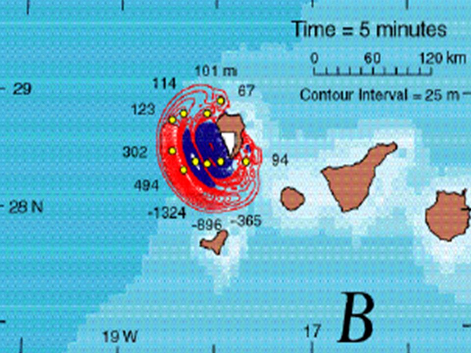
Volcanic eruption causing tsunami If the volcano erupts, it would send a large sized rock into the water The rock would create a mega- tsunami Hypothesized that the rock would equal the size of the Isle of Man Energy created from impact would equal almost ½ of electricity consumed in the U.S in one year Create a tsunami larger than any current tsunami recorded in history If the volcano erupts, it would send a large sized rock into the water The rock would create a mega- tsunami Hypothesized that the rock would equal the size of the Isle of Man Energy created from impact would equal almost ½ of electricity consumed in the U.S in one year Create a tsunami larger than any current tsunami recorded in history

7
Impact on civilization Atlantic coastlines of Africa and Europe would be affected Canary islands and U.S will also be affected After initial impact, dome of water would reach 900 meters (3,000 ft) high and 10 km wide This will immediately collapse, but then reform into smaller sizes Atlantic coastlines of Africa and Europe would be affected Canary islands and U.S will also be affected After initial impact, dome of water would reach 900 meters (3,000 ft) high and 10 km wide This will immediately collapse, but then reform into smaller sizes
 high and 10 km wide This will immediately collapse, but then reform into smaller sizes Atlantic coastlines of Africa and Europe would be affected Canary islands and U.S will also be affected After initial impact, dome of water would reach 900 meters (3,000 ft) high and 10 km wide This will immediately collapse, but then reform into smaller sizes")
8
Impact on Civilization continued First impact would occur at the West Saharan coast of Morocco Wave would measure 330 ft. from crest to trough Tsunami would travel about 155 miles in 10 minutes 9-10 hours after impact, wave of 164 ft. high would hit coasts of Florida and the Caribbean Wave would travel 4-5 miles inland Weaker waves will travel along the western coast of Iberian Peninsular and France and hit the Atlantic coastline of Britain Wave of 130 ft. would hit northern coast of Brazil These impacts would create much devastation throughout the world First impact would occur at the West Saharan coast of Morocco Wave would measure 330 ft. from crest to trough Tsunami would travel about 155 miles in 10 minutes 9-10 hours after impact, wave of 164 ft. high would hit coasts of Florida and the Caribbean Wave would travel 4-5 miles inland Weaker waves will travel along the western coast of Iberian Peninsular and France and hit the Atlantic coastline of Britain Wave of 130 ft. would hit northern coast of Brazil These impacts would create much devastation throughout the world

18
Massive Collapse vs Gradual Sliding The worst case scenario involves a monolithic 500km 3 rock Massive failures such as this are extremely rare and are far from the norm. Ocean sediment samples support this. 500km3 of rock broken into many pieces will create much smaller waves than one 500km3 rock. “If you break [a brick] up into 10 pieces and drop them in one by one you're going to get 10 much smaller splashes” Russell Wynn, Southampton Oceanography Centre

19
Cumbre Vieja’s (Un)stability A massive collape of La Palma would require great amounts of energy from a catastophic event. There is little evidence that such an event could occur. La Palma has been volcanically active, however: - La Palma is a shield volcano. Most eruptions are non- explosive. - There is no evidence showing that Cumbre Vieja’s main fault goes down to the base of the island. - Erosion along the flanks of La Palma has created dykes that support incremental collapse. A massive collape of La Palma would require great amounts of energy from a catastophic event. There is little evidence that such an event could occur. La Palma has been volcanically active, however: - La Palma is a shield volcano. Most eruptions are non- explosive. - There is no evidence showing that Cumbre Vieja’s main fault goes down to the base of the island. - Erosion along the flanks of La Palma has created dykes that support incremental collapse.

21
Difficulties in Modeling Modeling a massive flank collapse is difficult because such an event has not occurred during recorded history. Given how little data we have on such collapses, much speculation goes into the initial parameters of the model. The parameters used in the original report have received criticism for being overstated. Other geologists have modeled the worst case scenario and have gotten maximum wave heights of 1-3m for the eastern seaboard. The original report done by the Benfield Hazard Research Center stating the possibility of a mega-tsunami was funded in whole by an insurance company. Modeling a massive flank collapse is difficult because such an event has not occurred during recorded history. Given how little data we have on such collapses, much speculation goes into the initial parameters of the model. The parameters used in the original report have received criticism for being overstated. Other geologists have modeled the worst case scenario and have gotten maximum wave heights of 1-3m for the eastern seaboard. The original report done by the Benfield Hazard Research Center stating the possibility of a mega-tsunami was funded in whole by an insurance company.

23
Works Cited http://archives.cnn.com/2001/TECH/science/ 08/29/tidal.wave/index.html http://archives.cnn.com/2001/TECH/science/ 08/29/tidal.wave/index.html http://news.bbc.co.uk/1/hi/sci/tech/3553368. stm http://news.bbc.co.uk/1/hi/sci/tech/3553368. stm http://dsc.discovery.com/news/briefs/200501 10/tsunamidanger_zoom1.html http://dsc.discovery.com/news/briefs/200501 10/tsunamidanger_zoom1.html http://www.es.ucsc.edu/~ward/papers/La_Pa lma_grl.pdf http://www.es.ucsc.edu/~ward/papers/La_Pa lma_grl.pdf http://archives.cnn.com/2001/TECH/science/ 08/29/tidal.wave/index.html http://archives.cnn.com/2001/TECH/science/ 08/29/tidal.wave/index.html http://news.bbc.co.uk/1/hi/sci/tech/3553368. stm http://news.bbc.co.uk/1/hi/sci/tech/3553368. stm http://dsc.discovery.com/news/briefs/200501 10/tsunamidanger_zoom1.html http://dsc.discovery.com/news/briefs/200501 10/tsunamidanger_zoom1.html http://www.es.ucsc.edu/~ward/papers/La_Pa lma_grl.pdf http://www.es.ucsc.edu/~ward/papers/La_Pa lma_grl.pdf

Similar presentations


 eruptions Explosive (Subduction)>")

 Mantle Outer Core Inner Core Scientists discovered these.>")


