Download presentation
Presentation is loading. Please wait.

1
SCAGI Community Projects SCAR map catalogue Total 5850 maps - 26 countries 767 digital maps (722 Australia) UK 801 Argentina 97 Uruguay 2 Poland 1 France 104 USA 641 India 4 Japan 327 Brazil 2 Sth Africa 39 Bulgaria 3 Ecuador 1 Norway 126 Chile 40 Australia 2699 Chile 40 Germany 106 Russia 555 Russia 555 China 9 Spain 6 Canada 4 Sweden 1 Italy 55 Belgium 7
 UK 801 Argentina 97 Uruguay 2 Poland 1 France 104 USA 641 India 4 Japan 327 Brazil 2 Sth Africa 39 Bulgaria 3 Ecuador 1 Norway 126 Chile 40 Australia 2699 Chile 40 Germany 106 Russia 555 Russia 555 China 9 Spain 6 Canada 4 Sweden 1 Italy 55 Belgium 7")
2
SCAGI Community Projects SCAR map catalogue Related to SCAR Composite Gazetteer Antarctica Shows all information about maps including Title Edition Scale Publishers Data layers Spatial coverage Dimensions National reference (if provided) Key words Horizontal and vertical datums
 Key words Horizontal and vertical datums")
3
SCAGI Community Projects SCAR map catalogue Related to SCAR Composite Gazetteer Antarctica Shows all information about maps including Place names of country within a particular countries map Place names of all countries within a map Links to Species – Flora and Fauna within the map Thumb print of the map when provided Download of PDFs for printing if provided

4
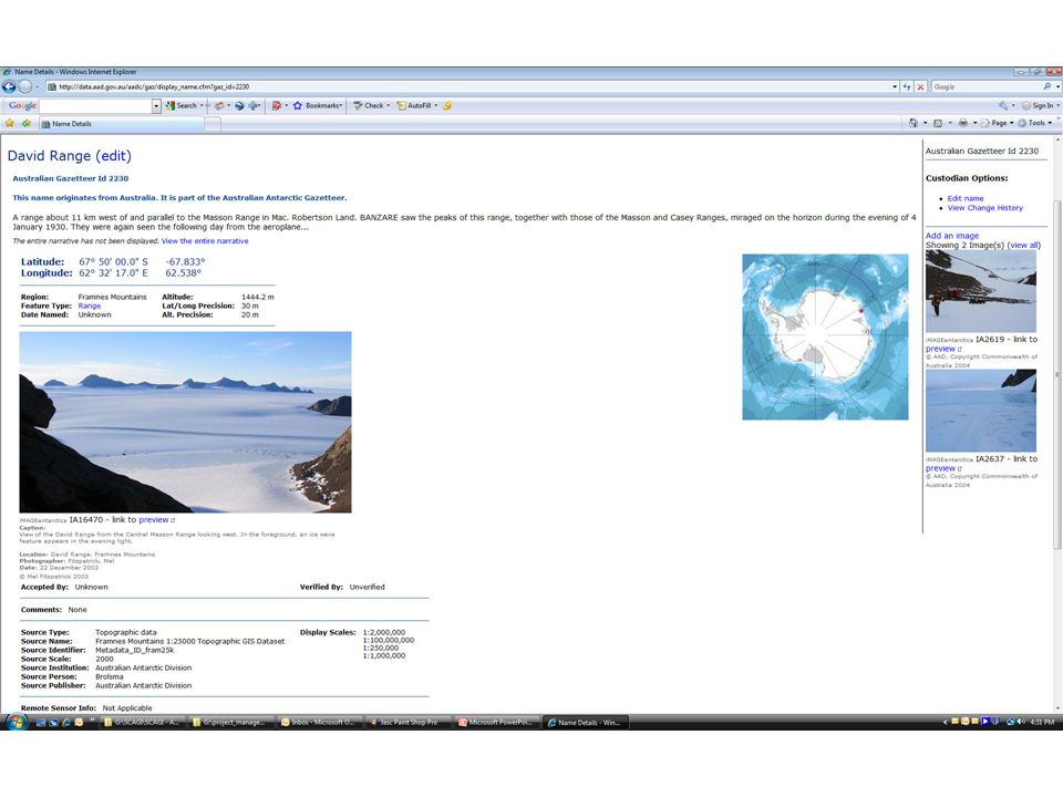
SCAGI Community Projects SCAR map catalogue

6
SCAGI Community Projects SCAR CGA

7
Gazetteer of names – 26 countries 36,012 names for 17,500 features Linked to SCAR Map catalogue SCAR Feature catalogue SCAR MarBIN Biology database Developed to include photos, origin of coordinates, source of information Total 26 fields - future work populating

8
SCAGI Community Projects SCAR CGA Related to: SCAR map catalogue, SCAR feature catalogue, SCAR flora and fauna databases Shows Coordinates Country of origin for place name Generic term Feature type Class type Source of data coordinates derived from Accuracy of coordinates – needs further definition

9
SCAGI Community Projects SCAR CGA Recent developments – additional fields Coordinate accuracy Elevation Feature type Institution Person at institution Source type – map, satellite image, GPS Map scale Status - official, historical, disappeared Comments Add photo of features All definitions fields on SCAR CGA home page

11
SCAGI Community Projects SCAR Feature Catalogue Related to Scar CGA Describes Feature types Terminology Relationship to ISO 19110 Datasets and quality Search Australian data sets for quality IDs Q-info required when quality information is required for each feature instance, rather than the metadata that describes quality information for the dataset. Linked to metadata

12
SCAGI Community Projects SCAR Feature Catalogue

Similar presentations


 Adrian Fox (BAS)>")

>")
 Recommend That.>")


 - Place-names.>")


 Draws on global operational network, and analytical engine –SRM website provides quick overview.>")
