Download presentation
Presentation is loading. Please wait.

1
GEOSS Task AR-09-01b Architecture Implementation Pilot AIP Phase 4, (AIP-4) AIP Task Team February 2011
 AIP Task Team February 2011")
2
GEO Task AR-09-01b Architecture Implementation Pilot fostering interoperability arrangements and common practices for GEOSS

3
AIP-4 Call for Participation CFP Main Body AIP Evolutionary Development Process GEOSS Services Architecture

4
GEOSS AIP Phase 4 (AIP-4) SBAs: Increasing implementation of GEOSS with CoPs Data: Foster access to EO Priority Observations consistent with Data-CORE and Interoperability Arrangements. GCI: Utilize the agreed components baseline DRAFT Schedule and Priorities

5
SBAs supported by GCI and Data Servers GEOSS CORE-Priority EO Parameter Access Services Communities of Practice WaterEnergy Data sharing Data Harmonization... GCI CoP Toolkit Data Server deployment

6
AIP-4 Scope - draft Communities of Practice: SBA Integrators, CoP Toolkit GCI selected components as baseline Data Servers: –Foster access to UIC Priority Observations consistent with Data-CORE and Interoperability Arrangements Technology development –Semantics and ontologies for mediation –Data harmonization: quality, schemas –Data Sharing: DSTF, User identity

7
AIP-4 Call for Participation CFP Main Body AIP Evolutionary Development Process GEOSS Services Architecture

8
Operational Capability Operational Capability User Needs, Scenarios User Needs, Scenarios Design, Develop, Deploy Design, Develop, Deploy ADC activities including: Architecture Implementation Pilot (AIP) Task AR-09-01b GEOSS Common Infrastructure (GCI) Task AR-09-01a support persistent implementation requirements SBA Tasks, UIC, CBC, STC A process, elaboration of GEOSS Architecture Consider: Role of Task Forces Role of CoPs Other ADC tasks: DIAS
 Task AR-09-01b GEOSS Common Infrastructure (GCI) Task AR-09-01a support persistent implementation requirements SBA Tasks, UIC, CBC, STC A process, elaboration of GEOSS Architecture Consider: Role of Task Forces Role of CoPs Other ADC tasks: DIAS")
9
AIP Evolutionary Development Phases has piloted the GEOSS 10 Year Plan Architecture AIP-1 –Kickoff: June 2007 –Result: "Core" Architecture defined most of the GCI IOC – Architecture Workshop AIP-2 –Kickoff: September 2008 –Result: SBA implementations of common cross- cutting architecture AIP-3 –Kickoff: March 2010 –Result: Enabled data sharing and network building in GEOSS SBA communities

10
DevelopmentActivities Kick-offWorkshop Call for Participation ConceptDevelopment PersistentOperations(AR-09-01a) Participation ArchitectureDocumentation Updates for each step Baseline AR-09-01b Architecture Implementation Pilot Evolutionary Development Process Operational Baseline and Lessons Learned for next evolutionary spiral Continuous interaction with external activities AIP Development Approach
 Participation ArchitectureDocumentation Updates for each step Baseline AR-09-01b Architecture Implementation Pilot Evolutionary Development Process Operational Baseline and Lessons Learned for next evolutionary spiral Continuous interaction with external activities AIP Development Approach")
11
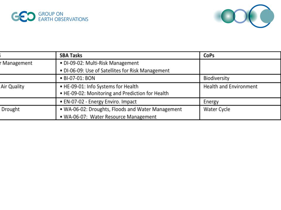
AIP coordinates with other GEO Tasks DI-09-02: Multi-Risk Management DI-06-09: Use of Satellites for Risk Management WA-06-02: Droughts, Floods and Water Management WA-06-07: Water Resource Management BI-07-01: BON EN-07-02 - Energy Enviro. Impact HE-09-01: Info Systems for Health HE-09-02: Monitoring and Prediction for Health US-09-01: User Engagement DA-06-01: Data Sharing Principles DA-09-01: Data Management DA-09-02: Data Integration and Analysis DA-09-03: Global Data Sets AR-09-02: Interoperable Systems for GEOSS AR-09-04: Dissemination and Distribution Networks AG- Agriculture Task

13
Community of Practice: Chartered to meet Decision Support needs Community of Interest/Practices and AIP SBA/CoP Integrator Service Providers: Data, Observation, Mediation, Processing CoP Science Community GCI Community of Interest: Birds of a feather, discussion group Communities of Practices in AIP-4: -Integrated Global Water Cycle Obs. -Energy -Air Quality -Biodiversity -Global Agricultural Monitoring? -Geohazards? SBA/CoP Integrator -Lead AIP CoP WG -Liaison from AIP to CoP -Expert in SBA science and geoinformatics -Lead application of GEOSS architecture to CoP

14
CoPs supported by AIP Objective: Work with CoPs to increase network building and data sharing Role of the SBA Integrator –Builds network through Community Portal, using CoP toolkit and other information and services to meet the needs of the community –Build on the best practices and interoperability arrangements. CoP Toolkit –Community Portals and Application Clients for DSS needs –Community Catalogues –Priority Data Servers for SBA

15
EC FP7 Projects Participating in AIP Current in AIP-3 –EnerGEO, –EO2Heaven, –EuroGEOSS, –GENESIS, –GIGAS, –GIS4EU, –SAFER, –UncertWEB New contributions possible: –ISTIMES - DM –DEWFORA- Drought –ENDORSE: "Energy Services for GMES" - www.endorse- fp7.euwww.endorse- fp7.eu –GeoViQua –GLOWASIS - Water –(Current GCI call)
")
16
AIP-4 Call for Participation CFP Main Body AIP Evolutionary Development Process GEOSS Services Architecture

17
Architecture Viewpoints Information Viewpoint Computational Viewpoint Engineering Viewpoint Implementation/Development Viewpoints in Reference Model - Open Distributed Processing (RM-ODP) ISO/IEC 10746 Technology Viewpoint Enterprise Viewpoint Community Objectives Business aspects: purpose, scope and policies What for? Why? Who? When? Information sources and models What is it about? Types of services and protocols How does each bit work? Solution types: distribution infrastructure How do the components work together? Implementation system: hardware, software, distribution With what? Abstract/Best Practices

18
SBAs for AIP-4 Established –Disaster Management –Energy –Health: Air Quality –Water Drought –Arctic SDI –Biodiversity and Climate Change New in AIP-4 –Agriculture Maybe in AIP-4 –Climate (Liping NOAA) –Weather (FP7) One page for each SBA needed in the following pages GEOSS SoA Enterprise Viewpoint
 –Weather (FP7) One page for each SBA needed in the following pages GEOSS SoA Enterprise Viewpoint")
19
Disaster Management (Arnaud, GIS-FCU) GEOSS SoA Enterprise Viewpoint
 GEOSS SoA Enterprise Viewpoint")
20
Energy AIP-2 and AIP-3 have established the GGI capacity to disseminate Energy and Environment related Web Services using existing standard (OGC). The on-going FP7 MACC project has established Quality and Uncertainties, as key parameters to be part of any data set for Energy and/or Environment Focus for AIP-4 will be made on: –Providing end-user with Quality and Uncertainties parameters for any relevant data set at Metadata level for Search & Discovery purpose and at Web Service level for end-user full information presentation –Selecting the suitable development framework for building Graphical User Interface that has the capacity to trigger remote Web Services (WMS, WFS and WPS) in operational services such as SoDa Support will be needed from existing initiative such as QA4EO to help Energy Web Services providers to properly build Metadata taking into account the Quality and the Uncertainties parameters associated to the data sets. Metadata should latter be deployed on a GEOSS compliant Catalogue. Collaboration with GEO Portal developers should be considered in order to ensure a proper and consistent dissemination and presentation of Energy and Environment data sets on the GEO Portal A persistent example addressing Quality and Uncertainty parameters should be deployed as a Web Service, preferably exploited in an operational service such as SoDa. This Web Service should be able to properly carry those parameters for end-users information. Search, Find Bind mechanism must be addressed and demonstrated through the GEO Web Portal facilities. Web-based applications using generic framework and triggering Energy and/or Environment related Web Services must be realized. These Web-based applications must ensure that they properly display the Quality and Uncertainties parameters attached to the geo-localized data. Collaboration with IT partners offering existing frameworks is foreseen. Reference to MACC project: http://www.gmes-atmosphere.eu/documents/deliverables/r-rad/D_R-RAD_2.1_1.RAD.MACC.v1.0.pdf
 in operational services such as SoDa Support will be needed from existing initiative such as QA4EO to help Energy Web Services providers to properly build Metadata taking into account the Quality and the Uncertainties parameters associated to the data sets. Metadata should latter be deployed on a GEOSS compliant Catalogue. Collaboration with GEO Portal developers should be considered in order to ensure a proper and consistent dissemination and presentation of Energy and Environment data sets on the GEO Portal A persistent example addressing Quality and Uncertainty parameters should be deployed as a Web Service, preferably exploited in an operational service such as SoDa. This Web Service should be able to properly carry those parameters for end-users information. Search, Find Bind mechanism must be addressed and demonstrated through the GEO Web Portal facilities. Web-based applications using generic framework and triggering Energy and/or Environment related Web Services must be realized. These Web-based applications must ensure that they properly display the Quality and Uncertainties parameters attached to the geo-localized data. Collaboration with IT partners offering existing frameworks is foreseen. Reference to MACC project:")
21
Health: Air Quality (Stefan/NGC, EO2Heaven) Durban Scenario GEOSS SoA Enterprise Viewpoint
 Durban Scenario GEOSS SoA Enterprise Viewpoint")
22
Water - Drought (Will Pozzi) Global Drought Monitor Satellite monitoring - Liping GEOSS SoA Enterprise Viewpoint
 Global Drought Monitor Satellite monitoring - Liping GEOSS SoA Enterprise Viewpoint")
23
GEOSS Architecture Implementation Pilot, Phase 4, GEO Water Tasks Will Pozzi and George Percivall GEO Task WA-06-02b, Impacts of Drought, Co-POC and NASA WaterNet Project Manager, and Open Geospatial Consortium, GEO Task AR-09-01b Task POC Presentation before the 2010 GEO Drought Response Initiative, Winnipeg, CA, 10 May 2010 www.ogcnetwork.net/AIP

24
Proposed Decision Making Services in the Final GEO Water Societal Benefit Area Workplan (discussed within IGWCO and Doug Cripe) courtesy of Justin Sheffield, Princeton, African Drought Monitor Global Drought Monitoring and Early Warning Service
 courtesy of Justin Sheffield, Princeton, African Drought Monitor Global Drought Monitoring and Early Warning Service")
25
Proposed Decision Making Services in the Final GEO Water Societal Benefit Area Workplan (discussed within IGWCO and Doug Cripe) Architecture courtesy of USA NOAA National Office of Hydrology Remote Sensing Center (NOHRSC) Cryosphere Monitoring Service
 Architecture courtesy of USA NOAA National Office of Hydrology Remote Sensing Center (NOHRSC) Cryosphere Monitoring Service")
26
Drought Early Warning requires assembly within an information system (GEOSS) the uses of water, so that drought vulnerability can be assessed or included Soil Moisture in the European Union Europe Drought Observatory: agricultural impact (http://edo.jrc.ec.europa.eu/php/index.php?action=view&id=19)http://edo.jrc.ec.europa.eu/php/index.php?action=view&id=19 Agricultural use, cooling water for power generation, domestic use, environmental flow requirement for ecosystems
 the uses of water, so that drought vulnerability can be assessed or included Soil Moisture in the European Union Europe Drought Observatory: agricultural impact ( action=view&id=19) action=view&id=19 Agricultural use, cooling water for power generation, domestic use, environmental flow requirement for ecosystems")
27
Agriculture (Liping Di) Crop condition monitoring USDA, China, CoP Will – irrigation water GEOSS SoA Enterprise Viewpoint
 Crop condition monitoring USDA, China, CoP Will – irrigation water GEOSS SoA Enterprise Viewpoint")
28
Arctic SDI (Doug N, EEA?) GEOSS SoA Enterprise Viewpoint
 GEOSS SoA Enterprise Viewpoint")
29
Biodiversity and Climate Change (Mattia, CNR and USGS) GEOSS SoA Enterprise Viewpoint
 GEOSS SoA Enterprise Viewpoint")
30
Climate and Weather WMO Information System (WIS) NESDIS: Martin CEOS? GOOS - Liping GEOSS SoA Enterprise Viewpoint

31
GEOSS Information framework GEOSS SoA Information Viewpoint

32
Data Harmonization in AIP-4 (Herve updates) Uncertainty – GeoViqua, UncertWeb QA4EO - CEOS Data Schemas – INSPIRE –Test Facility for validating schemas GEOSS SoA Information Viewpoint
 Uncertainty – GeoViqua, UncertWeb QA4EO - CEOS Data Schemas – INSPIRE –Test Facility for validating schemas GEOSS SoA Information Viewpoint")
33
Components deploy Services GEOSS Clearinghouse GEO Web Portal GEOSS Common Infrastructure Components & Services Standards and Interoperability Best Practices Wiki User Requirements Registries Main GEO Web Site Registered Community Resources Community Portals Client Applications Client Tier Mediation Tier Community Catalogues Alert Servers Workflow Management Processing Servers Access Tier GEONETCast Product Access Servers Sensor Web Servers Model Access Servers Test Facility Mediation Servers GEOSS SoA Engineering Viewpoint

34
Component Development in AIP-4 GCI usage and enhancement –New: Ontology Registry, URR Community Portals –CEOS portals for Virtual Constellations and CWIC –CBC connection Data Servers –Data Sharing –Geoss data CORE GEOSS SoA Engineering Viewpoint

35
CoP web presence: Community Portals IGWCO not on Community Portal –Watercycleforum.com Nadine GEOSS SoA Engineering Viewpoint

36
Deployment of Priority data services Deploying a data service –See AIP-2 video Metadata for adding into GCI –Confirm visibility (browse, access) in GWP Data Sharing: CORE, user registration/identity –Metadata about data sharing Data harmonization: schemas, quality. Used by many CoPs GEOSS SoA Engineering Viewpoint

37
Make priority data fully available as services US-09-01a Critical Earth Observation Priorities DSTF GEOSS Data-CORE Roadmap Compare the 2 lists Highest Ranked EO Parameters Datasets tagged as CORE (Pledge List) AIP-4 Access Services Pilot Priority EO Parameters available as CORE GEOSS CORE-Priority EO Parameter Access Services Sbageotask.larc.nasa.gov CORE = full and open with no restrictions. No data reuse conditions. There may be cost and attribution requirements. No cost recovery in AIP-4 DIAS connection to this emphasis? GTHN – Global terrestrial Hydro Network

38
Data Sharing (Steve Browdy) Working with the DSTF, User Management –User identity –User registration Data Access Conditions: –Data-CORE, Non-Commercial Use, other let a user know when she/he is leaving the GEO site and entering another.
 Working with the DSTF, User Management –User identity –User registration Data Access Conditions: –Data-CORE, Non-Commercial Use, other let a user know when she/he is leaving the GEO site and entering another.")
39
Semantic Mediation (Cristiano, Nagai) Coordination with GEO task AR-09-01d on semantic mediation issues Support to the optimization and extension of the GI-DAC service broker Integration and harmonization of thematic thesauri with reference ones: Water Ontology from AIP-3 Drought Vocabulary from EuroGEOSS More contributions are welcome…
 Coordination with GEO task AR-09-01d on semantic mediation issues Support to the optimization and extension of the GI-DAC service broker Integration and harmonization of thematic thesauri with reference ones: Water Ontology from AIP-3 Drought Vocabulary from EuroGEOSS More contributions are welcome…")
40
References GEO –earthobservations.orgearthobservations.org GEO Architecture Implementation Pilot –www.ogcnetwork.net/AIpilotwww.ogcnetwork.net/AIpilot GEOSS registries and SIF –geossregistries.infogeossregistries.info George Percivall percivall@myogc.org Nadine Alameh nalameh@opengeospatial.org

Similar presentations
 Doug Nebert U.S. Geological Survey February 5,>")
 AIP Task Team February 2011.>")


 March 2012.>")


 Slides provided by Bart De Lathouwer Open Geospatial Consortium AIP Lead>")
 Nadine Alameh, George Percivall, Ingo Simonis Open Geospatial Consortium (OGC) GEOSS.>")

 for the C4 Meeting Ivan B. DeLoatch, ADC Co-chair June 2008.>")


 R.Shibasaki (ADC, Japan)>")