Download presentation
Presentation is loading. Please wait.

1
geology.utah.gov 3/09 UTAH GEOLOGICAL SURVEY Landforms of Utah Fifth Grade Science Concepts

2
Utah Science Core Curriculum 5 th Grade Standard II Students will understand that volcanoes, earthquakes, uplift, weathering, and erosion reshape Earth’s surface. Obj. 1 Describe how weathering and erosion change Earth’s surface. Obj. 2 Explain how volcanoes, earthquakes, and uplift affect Earth’s surface. Obj. 3 Relate the building up and breaking down of Earth’s surface over time to the various physical land features. geology.utah.gov 3/09 UTAH GEOLOGICAL SURVEY Science Benchmark The Earth’s surface is constantly changing. Some changes happen very slowly over long periods of time, such as weathering, erosion, and uplift. Other changes happen abruptly, such as landslides, volcanic eruptions, and earthquakes. All around us, we see the visible effects of the building up and breaking down of the Earth’s surface.

3
geology.utah.gov 3/09 UTAH GEOLOGICAL SURVEY List of slides * 1.Landforms of Utah 2.5 th grade science core curriculum 3.List of slides 4.Quick outline Objective 2 5.How volcanoes, earthquakes, and uplift affect Earth’s surface. 6.Volcanoes create landforms 7.Volcanic eruptions create different mountains 8.Cinder cone and shield volcano 9.Composite volcano 10.Crater 11.Islands 12.Earthquakes create landforms 13.Fault 14.Fault scarp 15.Wasatch fault scarp 16.Mountains and valleys 17.Uplift creates mountains and plateaus 18.Uplift and different types of mountains 19.Volcanic mountains and fault-block mountains 20.Folded mountains and dome mountains 21.Plateaus Objective 1 22.Erosion on plateaus 23.River erosion & deposition / meandering river 24.Entrenched meanders 25.River erosion during flooding 26.Different canyon shapes 27.Glacier 28.Glacier erosion (cirque) 29.Glacier deposition (moraine) 30.Wind erosion & deposition 31.Weathering 32.Freeze-thaw weathering 33.Freeze-thaw weathering creates different geological features 34.How arches form 35.Arches vs. bridges Objective 3 36.Grand Canyon 37.Island in the Sky Extra 38.Lake Bonneville shorelines 39.Landslide – fast erosion & deposition * See notes with each slide for definitions and explanations. * Some slides are animated (so keep on clicking!)
 29.Glacier deposition (moraine) 30.Wind erosion & deposition 31.Weathering 32.Freeze-thaw weathering 33.Freeze-thaw weathering creates different geological features 34.How arches form 35.Arches vs. bridges Objective 3 36.Grand Canyon 37.Island in the Sky Extra 38.Lake Bonneville shorelines 39.Landslide – fast erosion & deposition * See notes with each slide for definitions and explanations. * Some slides are animated (so keep on clicking!).")
4
geology.utah.gov 3/09 UTAH GEOLOGICAL SURVEY Quick outline Volcanoes can create mountains, craters, and islands. Volcanic eruptions can create different types of mountains: cinder cone, shield volcano, composite volcano. Earthquakes can create fault scarps, mountains and valleys. Uplift can create mountains and plateaus. Erosion on plateaus can create mesas, buttes, and pinnacles. River erosion and deposition / the meandering river. V-shape canyon eroded by a river. U-shape canyon eroded by a glacier. Wind erosion and deposition. Weathering. Arches vs. bridges. Objective 2 Explain how volcanoes, earthquakes, and uplift affect Earth’s surface (slides # 5 – 21) Objective 1 Describe how weathering and erosion change Earth’s surface (slides # 22 – 35) Objective 3 Relate the building up and breaking down of Earth’s surface over time to the various physical land features (slides # 36 - 37)
 Objective 1 Describe how weathering and erosion change Earth’s surface (slides # 22 – 35) Objective 3 Relate the building up and breaking down of Earth’s surface over time to the various physical land features (slides # ).")
5
geology.utah.gov 3/09 UTAH GEOLOGICAL SURVEY Volcanic eruptions can create mountains and other landforms. Earthquakes can create small to large landforms, including mountains and valleys. Uplift can result in mountains and plateaus. Objective 2 Explain how volcanoes, earthquakes, and uplift affect Earth’s surface.

6
geology.utah.gov 3/09 UTAH GEOLOGICAL SURVEY Volcanoes can create... Craters Photo courtesy of NASA http://gohawaii.about.com/library/gallery/blgallery573.htm Islands Mountains pubs.usgs.gov/gip/volc/types.html

7
geology.utah.gov 3/09 UTAH GEOLOGICAL SURVEY Volcanic eruptions can create different types of mountains. Cinder cone near St. George Cinder cone Shield volcano north of Great Salt Lake Shield volcano Composite volcano http://Vulcan.wr.usgs.gov/volcanoes

8
geology.utah.gov 3/09 UTAH GEOLOGICAL SURVEY Cinder cone A small cone-shaped volcano with steep sides. Cinder cone near St. George Shield volcano A wide, low-profile volcano shaped like a flattened dome. Shield volcano north of Great Salt Lake

9
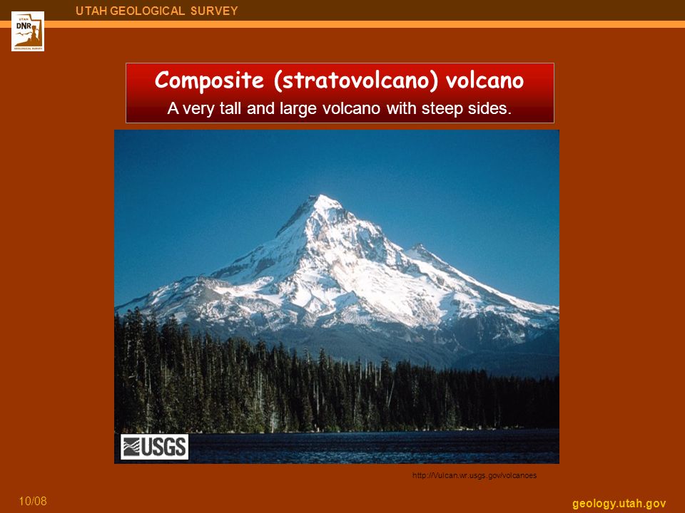
geology.utah.gov 10/08 UTAH GEOLOGICAL SURVEY Composite (stratovolcano) volcano A very tall and large volcano with steep sides. http://Vulcan.wr.usgs.gov/volcanoes
10
geology.utah.gov 3/09 UTAH GEOLOGICAL SURVEY Crater A circular-shaped depression at the top of a volcano formed by collapse from a large eruption.

11
geology.utah.gov 3/09 UTAH GEOLOGICAL SURVEY Island A land mass (smaller than a continent) that is surrounded by water. Photo courtesy of NASA http://gohawaii.about.com/library/gallery/blgallery573.htm The Hawaiian Islands are formed by volcanic eruptions.

12
geology.utah.gov 3/09 UTAH GEOLOGICAL SURVEY Earthquakes can create … Mountains and valleys Wasatch Range and Salt Lake Valley Fault scarps

13
geology.utah.gov 3/09 UTAH GEOLOGICAL SURVEY fault Fault A crack in the Earth’s surface along which two rock masses slide past one another.

14
geology.utah.gov 3/09 UTAH GEOLOGICAL SURVEY Fault scarp A steep break (escarpment) that forms where vertical fault movement reaches the ground surface.
 that forms where vertical fault movement reaches the ground surface.")
15
geology.utah.gov 3/09 UTAH GEOLOGICAL SURVEY Fault scarp formed by movement along the Wasatch fault. Juab County

16
Mountains and valleys geology.utah.gov 3/09 UTAH GEOLOGICAL SURVEY

17
geology.utah.gov 3/09 UTAH GEOLOGICAL SURVEY Uplift A rise of land to a higher elevation. Uplift can create … Tushar Mountains Mountains Digital.lib.uiowa.edu/cdm4/results.php?CISOOP Colorado Plateau Plateaus

18
geology.utah.gov 3/09 UTAH GEOLOGICAL SURVEY Uplift can result in creating different types of mountains. http://Vulcan.wr.usgs.gov/volcanoes Volcanic mountains Folded mountains Wasatch Range Fault-block mountains Navajo Mountain Dome mountains

19
geology.utah.gov 3/09 UTAH GEOLOGICAL SURVEY Fault-block mountain A mountain that rises along a fault. Wasatch Range Wasatch fault Volcanic mountain A mountain that forms as rising magma erupts onto the Earth’s surface. http://Vulcan.wr.usgs.gov/volcanoes

20
geology.utah.gov 3/09 UTAH GEOLOGICAL SURVEY Navajo Mountain Dome mountain A mountain produced where a region of flat-lying sedimentary rocks is bowed upward to form a structural dome. Folded mountain A mountain formed by compression of the Earth’s crust. http://gsc.nrcan.gc.ca/natmap/cf/images/syncline440.gif

21
geology.utah.gov 3/09 UTAH GEOLOGICAL SURVEY Wasatch Plateau Plateau A large, wide landform that is much higher than the adjacent land. Kaiparowits Plateau Straight Cliffs Digital.lib.uiowa.edu/cdm4/results.php?CISOOP Colorado Plateau

22
geology.utah.gov 3/09 UTAH GEOLOGICAL SURVEY Erosion on plateaus results in different geological features. mesa butte pinnacle Castle Valley Objective 1 Describe how weathering and erosion change Earth’s surface. Erosion The wearing away and carrying away of land by water, wind, or moving ice.

23
geology.utah.gov 3/09 UTAH GEOLOGICAL SURVEY River erosion and deposition San Juan River Picasaweb http://picasaweb.google.com/lh/view?q=san%20juan% 20river%20&psc=G&filter=1#5212557515730750498 Meandering rivers Erosion The wearing away and carrying away of land by water, wind, or moving ice. Deposition The laying down of eroded material (sediments) by water, wind, or moving ice.
 by water, wind, or moving ice..")
24
geology.utah.gov 3/09 UTAH GEOLOGICAL SURVEY Entrenched meanders San Juan River

25
geology.utah.gov 3/09 UTAH GEOLOGICAL SURVEY River erosion during flooding Santa Clara River

26
geology.utah.gov 3/09 UTAH GEOLOGICAL SURVEY Different types of erosion create different canyon shapes. Stream-eroded canyon “V-shaped” Mill Creek Canyon Glacier-eroded canyon “ U-shaped ” Little Cottonwood Canyon

27
geology.utah.gov 3/09 UTAH GEOLOGICAL SURVEY Glacier A large sheet of moving ice.

28
geology.utah.gov 3/09 UTAH GEOLOGICAL SURVEY Mt. Nebo Glacial erosion creates other geological features... Cirque Semi-circular bowl formed at the head of a glacier.

29
geology.utah.gov 3/09 UTAH GEOLOGICAL SURVEY Glacial deposition creates geological features... moraines Little Cottonwood Canyon Bells Canyon Wasatch fault Moraine Ridge-like landform deposited at the end or sides of a glacier.

30
geology.utah.gov 3/09 UTAH GEOLOGICAL SURVEY Wind erosion and deposition Little Sahara Recreation Area http://www.gps.caltech.edu/~carltape/personal/images/ge136/ge136_photos.html Moab

31
geology.utah.gov 3/09 UTAH GEOLOGICAL SURVEY Weathering The breaking down of rocks into smaller pieces by natural processes. Rocks can be broken down by water, air, chemicals, temperature changes (freezing and thawing), and plant and animal activity.
, and plant and animal activity..")
32
geology.utah.gov 3/09 UTAH GEOLOGICAL SURVEY Freeze-thaw weathering The breaking down of rock by repeated cycles of freezing and thawing of water in cracks and other openings in rock. stloe.most.go.th/.../302/images/3_2_3.jpg Water fills a crack and freezes to ice and expands, which can break apart the rock.

33
geology.utah.gov 3/09 UTAH GEOLOGICAL SURVEY Weathering caused by freeze-thaw can create... Rock falls Arches Arches National Park Hoodoos Bryce Canyon National Park

34
geology.utah.gov 3/09 UTAH GEOLOGICAL SURVEY Photo courtesy of Louis J. Maher, Jr. http://www.geology.wisc.edu/~ maher/air/air05.htm How arches form Landscape Arch

35
geology.utah.gov 3/09 UTAH GEOLOGICAL SURVEY Arches vs. Bridges Delicate Arch Arches National Park Owachoma Bridge Natural Bridges National Monument

36
geology.utah.gov 3/09 UTAH GEOLOGICAL SURVEY Objective 3 Relate the building up and breaking down of Earth’s surface over time to the various physical land features. Photo courtesy National Park Service http://www.nps.gov/archive/grca/photos/

37
geology.utah.gov 3/09 UTAH GEOLOGICAL SURVEY Candlestick Butte & Island in the Sky Canyonlands National Park

38
geology.utah.gov 3/09 UTAH GEOLOGICAL SURVEY Extra (1 of 2): for interested teachers Lake Bonneville shorelines Point of the Mountain (photo left) at the border of Salt Lake and Utah Counties
: for interested teachers Lake Bonneville shorelines Point of the Mountain (photo left) at the border of Salt Lake and Utah Counties")
39
geology.utah.gov 3/09 UTAH GEOLOGICAL SURVEY Extra (2 of 2): for interested teachers Fast/big step erosion and deposition by a landslide Thistle Landslide Utah County
: for interested teachers Fast/big step erosion and deposition by a landslide Thistle Landslide Utah County")
Similar presentations


