Download presentation
Presentation is loading. Please wait.

1
Unit IV: Political Organization of Space

2
Political Geography The study of the organization and distribution of political phenomena

3
Territory The effort to control territory is a central motivate of humans The territory of the world is almost completely divided into national units –Antarctica debated

4
Territoriality Territoriality is a key component of modern political culture Territorial Integrity – a government has the right to keep the borders and territory of a state in tact and free from attack.

5
State 1.an independent political unit occupying a defined territory 2. permanently populated territory 3. full sovereignty (independence to control internal affairs) 4. must be recognized by other states
 4. must be recognized by other states.")
6
World States 195 states (only 50 in the 1940s) 192 recognized by the United Nations Over 250 different nations
 192 recognized by the United Nations Over 250 different nations")
7
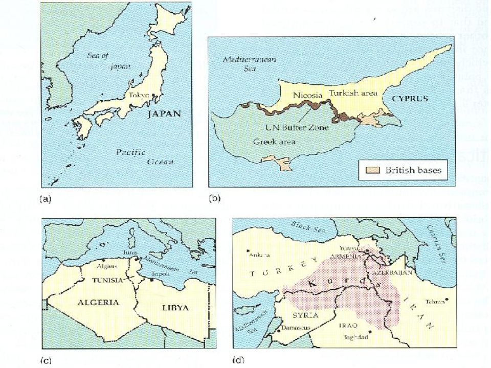
Issues defining states Political differences can cause some territories to not be recognized as independent. Examples: –Korea (2 states) –China and Taiwan-2 states? –Western Sahara (currently part of Morocco)
 –China and Taiwan-2 states. –Western Sahara (currently part of Morocco).")
8
Nation A group of people with a common culture occupying a particular territory, bound together by a strong sense of unity arising from shared beliefs and customs Nations are “ imagined communities ” -Benedict Anderson -imagined = you will never meet all the people in your nation -community = you see yourself as part of it

9
The nations we perceive as “ natural ” and “ always existing ” are relatively recent phenomena. In 1648, Europe was divided into dozens of small territories.

10
The Nation-State A state whose territorial extent coincides with that occupied by a distinct nation or people An entity whose members feel a natural connection by sharing language, religion, or some other cultural trait Iceland, Portugal, Poland, Japan

11
Stateless Nation Nations that do not possess a national territory even with a larger multinational state –Palestine, Kurds

12
Multinational State The Former Yugoslavia A state with more than one nation.

13
Multistate Nation Transylvania – homeland for both Romanians and Hungarians. A nation with more than one state

15
Largest Size –Russia 17.1 million square kilometers –Others: China, Canada, United States, and Australia Spatial Characteristics of States

16
Smallest Size –City-state: sovereign state compromised entirely of a city and it ’ s countryside Singapore, Monaco, San Marino –Microstates: very small land areas Smallest: Monaco -1.5 square kilometers Singapore, Andorra, and Bahrain

17
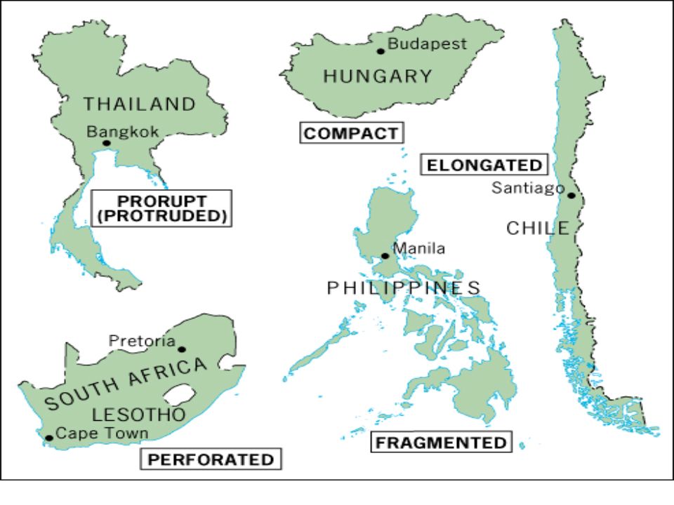
Spatial Characteristics of States 5 basic shapes –Compact –Prorupt –Elongated –Fragmented –Perforated

18
Shape – Compact Compact Most efficient form is a circle with a capital in the center Compact size Uruguay, Zimbabwe, Poland

19
A C B E D

20
Shape - Prorupt Nearly compact but posses one or more narrow extensions of territory Proruptions can be natural or artificial An isolate a portion of a state

21
A C B E D

22
Shape - Elongated Long and Narrow Distance from the capital is greater A large amount of diversity of climate, resources, and people National cohesion difficult Norway, Vietnam, Chile

23
A C B E D

24
Shape - Fragmented Countries composed entirely of islands (Philippines, Indonesia) Partly on Islands (Malaysia) Mainland – but separated Weakness centralized control
 Partly on Islands (Malaysia) Mainland – but separated Weakness centralized control")
25
A C B E D

26
Shape - Perforated State that completely surrounds another one Example: South Africa –Surrounds Lesotho –Completely dependent on South Africa for imports and exports

27
A C B E D

29
Relative Location Size and shape are affected by a state ’ s absolute and relative location Canada & Russia are large, yet their absolute northern location reduces the agricultural productivity of the land Iceland has a compact shape but its location near the artic makes much of its land barren

30
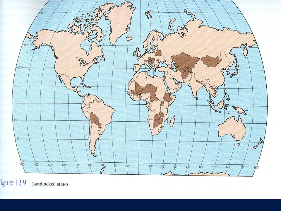
Relative Location Landlocked countries are at a major developmental disadvantage –Many in Africa due to remnants of colonialism –Must arrange to use another country ’ s sea port Coast lines can be a major advantage -Singapore (224 sq miles) is located at a crossroads of shipping and trade
 is located at a crossroads of shipping and trade")
32
The Modern State Idea The idea of a state that is tied to a particular territory with defined boundaries came out of Europe and diffused outward from there. –A change from society defining territory to territory defining society. –Modern States evolved in the late 1600s.

33
Rise of the Modern State 1.The European model a)The Norman invasion of 1066 produced a whole new political order b)On the European continent, the strength of some rulers produced national cohesiveness in more stable domains c)Economic revival and so called Dark Ages were over d)Treaties signed at the end of the Thirty Years' War contained fundamentals of statehood and nationhood - Peace at Westphalia e)Western Europe ’ s strong monarchies began to represent something more than authority
The Norman invasion of 1066 produced a whole new political order b)On the European continent, the strength of some rulers produced national cohesiveness in more stable domains c)Economic revival and so called Dark Ages were over d)Treaties signed at the end of the Thirty Years War contained fundamentals of statehood and nationhood - Peace at Westphalia e)Western Europe ’ s strong monarchies began to represent something more than authority")
34
Rise of the Modern State Mercantilism a) promotion of commercialism and trade with other states b)City-based merchants, not the nobility, gained wealth c)As money and influence were concentrated in the cities, land as a measure of affluence began to lose its relevance
 promotion of commercialism and trade with other states b)City-based merchants, not the nobility, gained wealth c)As money and influence were concentrated in the cities, land as a measure of affluence began to lose its relevance")
35
European Colonialism and the Modern State Colonialism –a physical action in which one state takes over control of another, taking over the government and ruling the territory as its own. Why? –Organized political states forming –Wealth from mercantilism to expand –Gained more wealth, territory, and power through colonialism

36
Diffusion of the Nation-State Model European Colonization influenced –State model the European model became the international model –Economic structure colonies and colonizers became interdependent in a capitalist world economy

37
Two Waves of European Colonialism: 1500 - 1825 1825 - 1975

38
Dominant Colonial Influences, 1550-1950 This map shows the dominant influence, as some places were colonized by more than one power in this time period.

39
What happened to state size?

40
Two Waves of Decolonization First wave – focused on decolonization of the Americas Second wave – focused on decolonization of Africa and Asia

42
Construction of the World Economy Capitalism – people, corporations, and states produce goods and services and exchange them in the world market, with the goal of achieving profit. Commodification – the process of placing a price on a good and then buying, selling, and trading the good. Colonialism – brought the world into the world economy, setting up an interdependent global economy.

43
The Capitalist World-Economy The World-Economy is more than the sum of its parts. It is composed of “dots” but we must also understand the “whole.” Sunday on La Grande Jatte by Georges Pierre Seurat

44
Immanuel Wallerstein ’ s World-Systems Theory: 1.The world economy has one market and a global division of labor. 2.Although the world has multiple states, almost everything takes place within the context of the world economy. 3.The world economy has a three-tier structure.

45
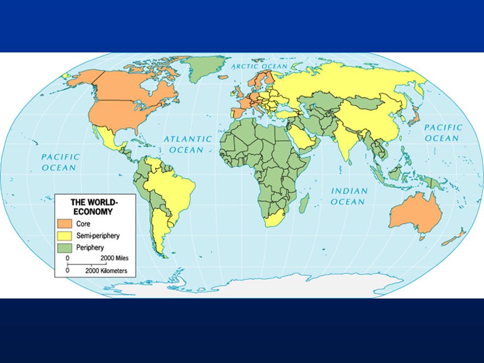
Three Tier Structure Core Processes that incorporate higher levels of education, higher salaries, and more technology * Generate more wealth in the world economy Semi-periphery Places where core and periphery processes are both occurring. Places that are exploited by the core but then exploit the periphery. * Serves as a buffer between core and periphery Periphery Processes that incorporate lower levels of education, lower salaries, and less technology * Generate less wealth in the world economy

46
Core Most states have assumed their current shape following centuries of growth Examples: North America, Western Europe, Japan, Australia

47
Periphery The benefits of the core area thin the farther you move outward Any resource benefits of the periphery are typically shipped backed to the core Examples: Africa (except South Africa), SE Asia, Western South America
, SE Asia, Western South America")
48
Semi-Periphery Exploited by the core, and exploit the periphery Examples: Mexico, Brazil, Russia, Eastern Europe, China, India

50
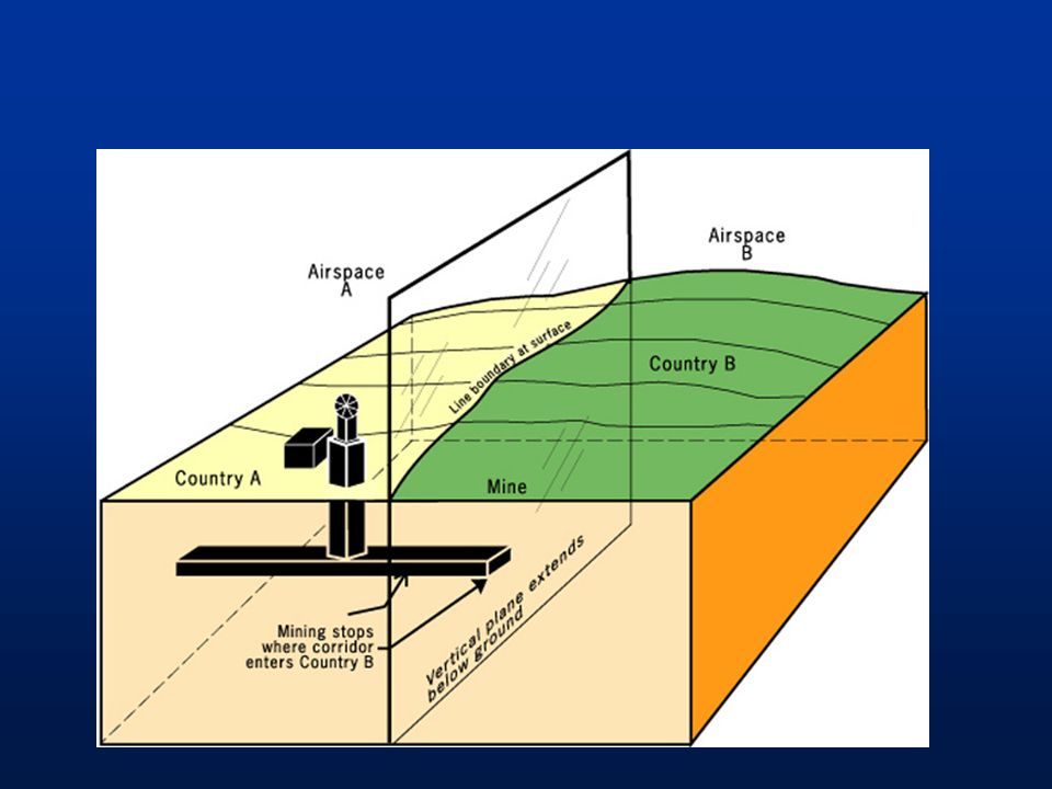
Boundaries Vertical lines that establish the limit of each state ’ s jurisdiction and authority Claims and boundaries are 3 dimensional –Subsoil Resource disputes –Airspace extends into airline traffic (satellites next?)
")
53
The Evolution of Boundaries Definition: the official establishment or documentation of a boundary –Treaty –Legal document –Example: 2000 Macedonia-Serbia and Montenegro delimitation agreement

54
The Evolution of Boundaries Delimitation: placing of the boundary on a map

55
The Evolution of Boundaries Demarcation: marking of the boundary by some method on the ground

56
Boundary Types Natural (physical): based on recognizable physiographic features –Mountains, rivers, and lakes –Can cause disputes
: based on recognizable physiographic features –Mountains, rivers, and lakes –Can cause disputes")
57
Boundary Types Law of the Sea –Territory 12 Nautical miles –Contiguous Zone 12 Nautical miles –Exclusive Economic Zone 200 Nautical Miles

58
Boundary Types Geometric (Artificial): follows parallels of latitude and meridians of longitude –49 th parallel United States & Canada –Africa, Asia, Americas
: follows parallels of latitude and meridians of longitude –49 th parallel United States & Canada –Africa, Asia, Americas")
60
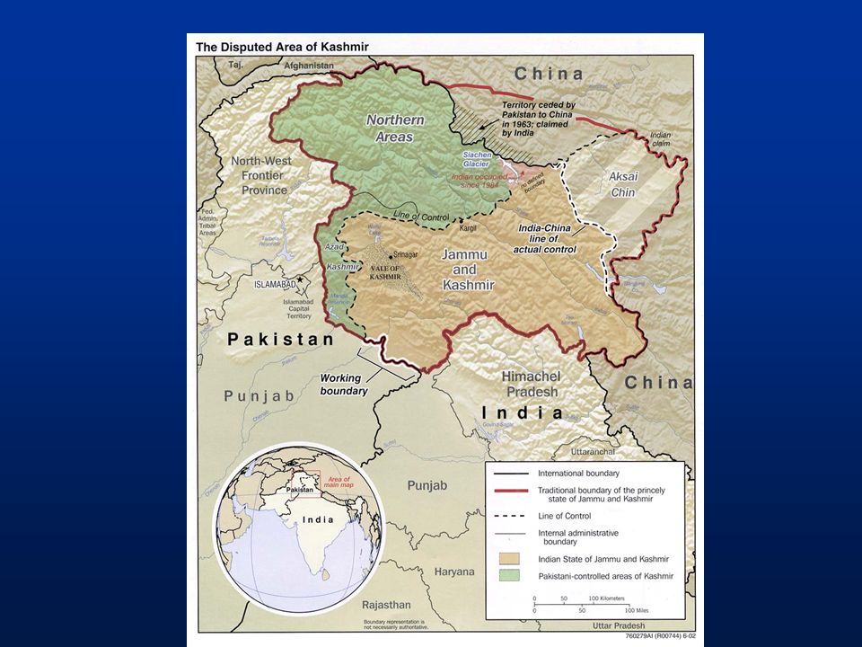
Boundary Types Cultural: separate groups by a common cultural trait –India and Pakistan

61
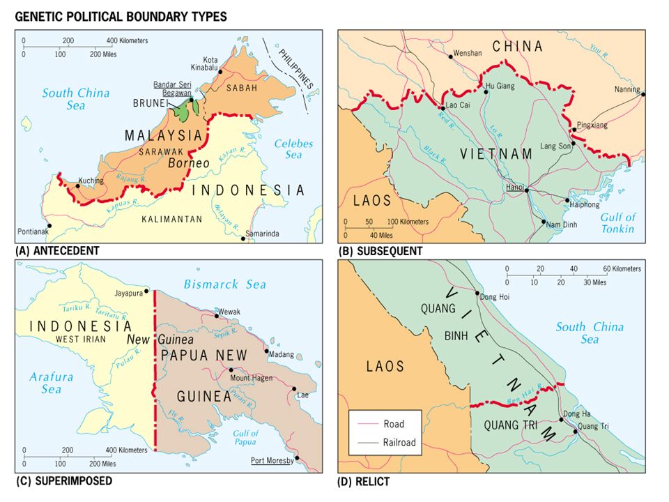
Boundary Origins Antecedent: border drawn before it was well populated –United States & Canada

62
Subsequent: border drawn after the development of the cultural landscape –2 types: Consequent Superimposed Boundary Origins

63
Consequent (ethnographic): border drawn to accommodate existing religious, linguistic, or ethnic differences –N. Ireland and Ireland Boundary Origins

64
Subsequent Superimposed Boundaries: forced on an existing cultural landscape, country, or people by a conquering colonial power –Unconcerned about preexisting cultural patterns –Great Britain = India/Pakistan Boundary Origins

65
Relict/relic Boundary: former boundary that no longer functions –Differences on each side of the border are still evident Boundary Origins

67
Definitional/Positional Boundary Disputes Focus on the legal language of the boundary agreement A boundary agreement may base a boundary on a landmark that has moved or no longer visible Argentina and Chile

68
Locational Boundary Disputes The delimitation and possible demarcation of the border is in dispute

69
Operational/Functional Disputes Neighboring states disagree over policies to be applied along a boundary Immigration

70
Allocation/Resource Disputes Neighboring states can argue about the distribution of resources United States v. Mexico Iraq v. Kuwait

71
Territorial Disputes A subsequent boundary divides and ethnically homogenous group Irredentism- advocating annexation of territories administered by another state on the grounds of common ethnicity or prior historical possession Germany, Somalia, Kashmir

73
Capitals Typically are centrally located to allow for equal access Many capitals have become distant to many areas due to growth: Washington D.C. Some capitals have been relocated to make the more accessible

74
Capitals Usually located in the core area and frequently the focus of it Capital cities are also frequently the largest or the Primate City Primate City: dominates the economic structure of the entire country

75
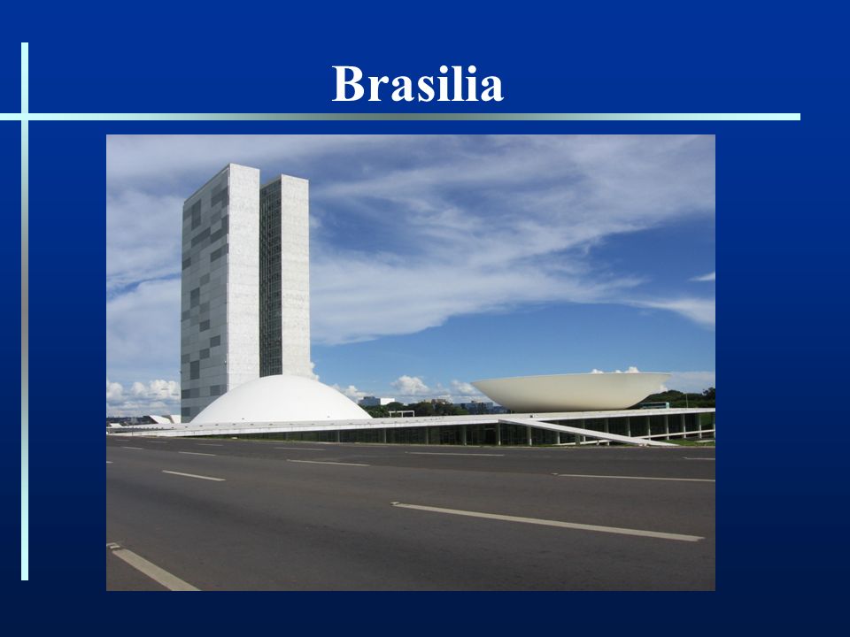
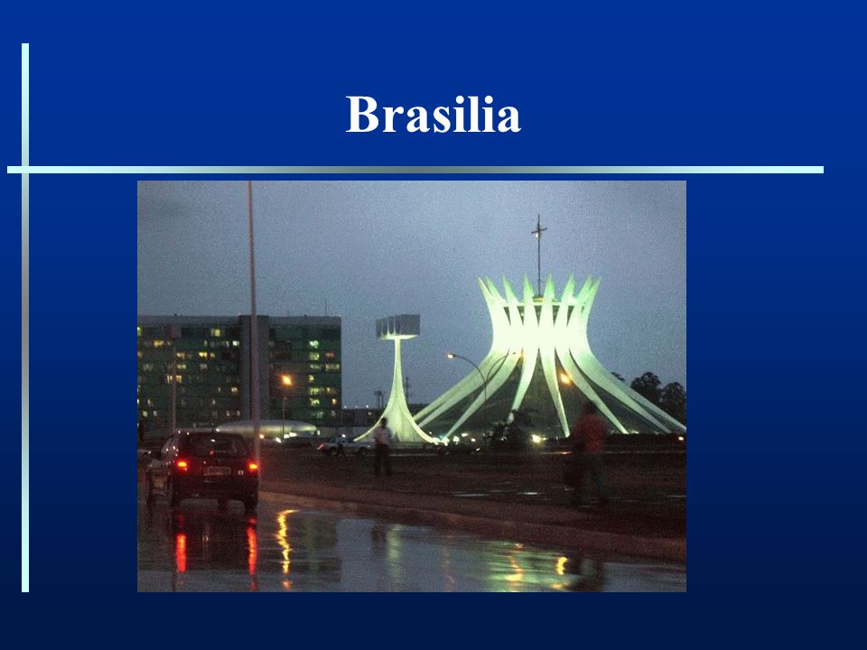
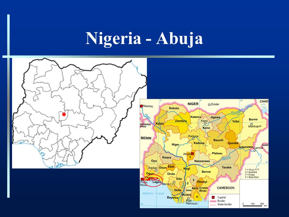
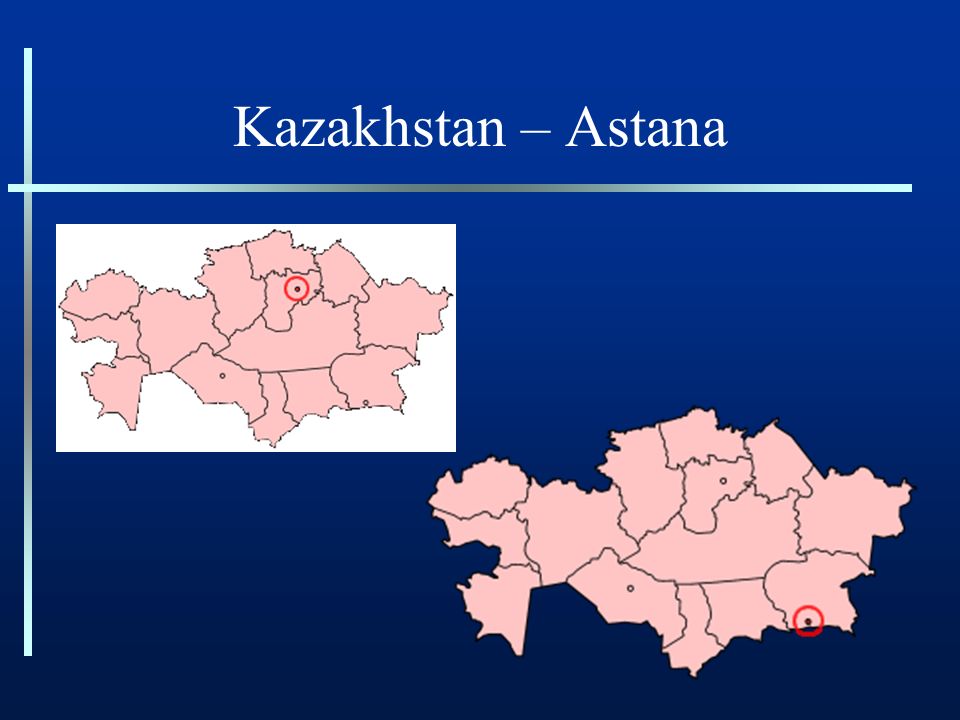
Forward-Thrust capital City Deliberately sited in a state ’ s interior Brazil relocated its capital from Rio de Janeiro to a new city called Brasilia Nigeria – Abula Kazakhstan – Astana

76
Brasilia

79
Nigeria - Abuja

81
Kazakhstan – Astana

83
Geopolitics Considers the strategic value of land and sea area in the context of national economic and military power and ambitions –power relationships: past, present, and future Manifest Destiny, Monroe Doctrine, “ Greater East-Asia Co-Prosperity Sphere ”

84
Geopolitics – German School Ratzel ’ s Organic Theory a)Held that a nation which is an aggregate of organisms would itself function and behave as an organism b)Nourishment of organism provided by acquisition of territories and people c)Territory is essential to life. d)Nazi expansion policies based on some of Ratzel ’ s ideas.
Nazi expansion policies based on some of Ratzel ’ s ideas..")
85
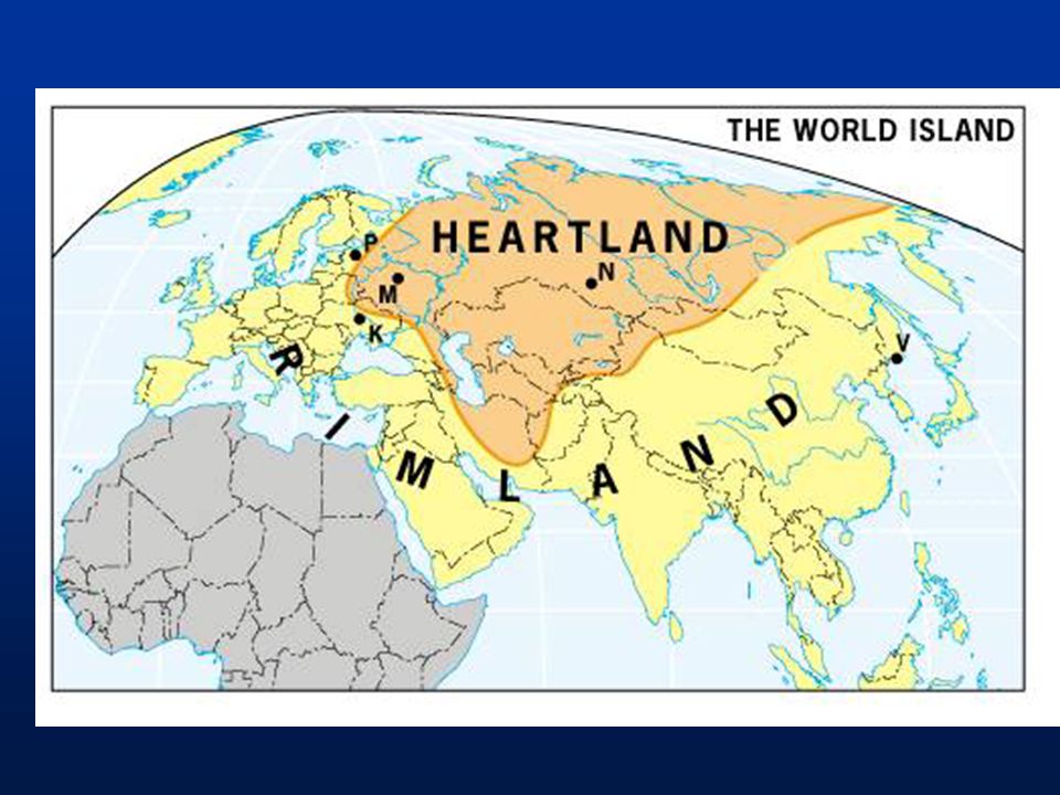
Sir Halford Mackinder Heartland Theory a)Believed a land-based power, not a sea power, would ultimately rule the world b)Pivot area extended from Eastern Europe to eastern Siberia Geopolitics – British/American School
Believed a land-based power, not a sea power, would ultimately rule the world b)Pivot area extended from Eastern Europe to eastern Siberia Geopolitics – British/American School")
87
Mackinder – Heartland Theory The Heartland is impenetrable Resource rich Provided a base for world conquest

88
Mackinder – Heartland Theory –“ Who rules East Europe commands the Heartland ” –“ Who rules the Heartland commands the World Island ” –“ Who rules the World Island commands the World ”

89
Geopolitics Nicholas Spykman - Rimland Theory Critic of Mackinder Argued that the Eurasian rim, not its heart, held the key to global power

91
Spykman-Rimland Fragmented zone Divided rimland key to balance of world power Dense population, abundant resources, controlling access to both the sea and the interior

92
“ Who controls the Rimland controls Eurasia ” “ Who rules Eurasia controls the destiny of the world ” Spykman-Rimland

93
Recent Geopolitical Developments Bipolar World Post WWII – Heartland = U.S.S.R NATO CENTO SEATO U.S. practiced Containment Confining the U.S.S.R by means of alliances with Rimland Military intervention Domino Theory

94
Geopolitics Today Current world events have rendered older geopolitical ideas obsolete End of the Cold War, Nuclear Technology, and Japan, China, W. Europe becoming world powers Unilateralism – United Sates dominance Will this last???

95
Current Geopolitics 2 Main Forms of Competition 1.Economic rivalry: core countries versus peripheral states 2.Conflicts between “ Civilizations ” Western, Confucian, Japanese, Islamic, Hindu, Slavic, Latin America, African Differences are antagonistic Enduring differences in history, language, culture, and religion

96
How do States Spatially Organize their Governments? Key Question:

97
Internal Structure 1.The needs of a well-functioning state a)Clearly bounded territory served by an adequate infrastructure b)Effective administrative framework, a productive core area, and a prominent capital 2.All states confront divisive forces
Clearly bounded territory served by an adequate infrastructure b)Effective administrative framework, a productive core area, and a prominent capital 2.All states confront divisive forces")
98
Forms of Government Unitary – highly centralized government where the capital city serves as a focus of power. Federal – a government where the state is organized into territories, which have control over government policies and funds.

99
Unitary and Federal Systems 1.Early European nation-states were unitary states: a)Governments were highly centralized and powerful b)Capital cities represented authority that stretched to the limits of the state
Governments were highly centralized and powerful b)Capital cities represented authority that stretched to the limits of the state")
100
Unitary and Federal Systems 2.The federal state arose in the New World a)Newness of the culture, and emergence of regionalism due to the vast size of territories b)Conditions did not lend themselves to unitary systems of government c)Absence of an old primate city d)Lack of a clear core area and the vastness of national territory
Newness of the culture, and emergence of regionalism due to the vast size of territories b)Conditions did not lend themselves to unitary systems of government c)Absence of an old primate city d)Lack of a clear core area and the vastness of national territory")
101
Nigeria ’ s Federal Government – Allows states within the state to determine whether to have Shari ’ a Laws Shari ’ a Laws Legal systems based on traditional Islamic laws

102
Minnesota ’ s concealed weapons law requires the posting of signs such as this on buildings that do not allow concealed weapons. The U.S. Federal Government – Allows states within the state to determine “ moral ” laws such as death penalty, access to alcohol, and concealed weapons.

103
Forces of Fragmentation and Cohesion: Centripetal and Centrifugal Forces

104
Centripetal Forces Promoting State Cohesion Nationalism Unifying Institutions Organization and Administration Transportation and Communication Supranationalism

105
Centrifugal Forces Challenges to State Authority Nationalism Devolution, Regionalism Peripheral Location Social and Economic Inequality

106
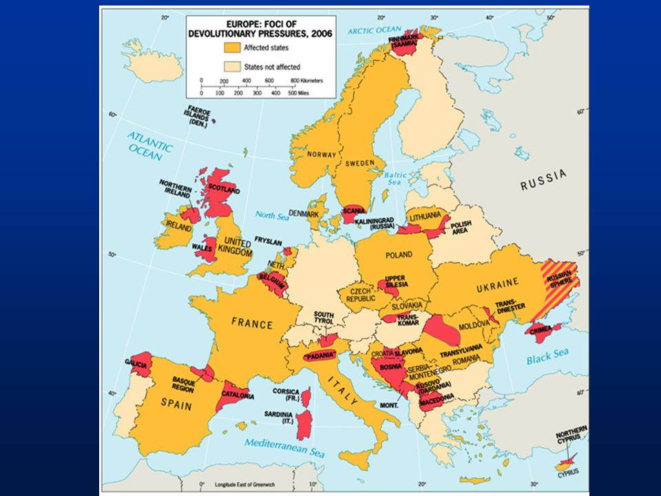
Devolution – Movement of power from the central government to regional governments within the state. What causes devolutionary movements? Ethnocultural forces Economic forces Spatial forces

107
Ethnocultural Devolutionary Movements Eastern Europe devolutionary forces since the fall of communism

109
Economic Devolutionary Movements Catalonia, Spain Barcelona is the center of banking and commerce in Spain and the region is much wealthier than the rest of Spain.

110
Spatial Devolutionary Movements Honolulu, Hawai ’ i A history apart from the United States, and a desire to live apart in order to keep traditions alive.

111
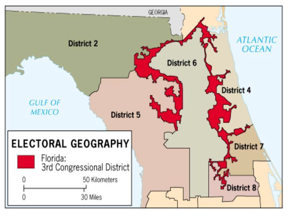
Electoral Geography 1.Electoral geographers a)Study spatial configuration of electoral districts b)Voting patterns c)Influence of voting patterns on social and political affairs
Study spatial configuration of electoral districts b)Voting patterns c)Influence of voting patterns on social and political affairs")
112
Electoral Geography Gerrymandering - redrawing of voting districts in such a way as to give one political party maximum political advantage Creating of majority-minority districts

114
Gerrymandering Stacked: drawing circuitous boundaries to enclose pockets of strength or weakness Excess vote: concentrates the votes of the opposition in a few districts which they can win easily, but leaves them few potential seats elsewhere Wasted vote: diffuses opposition ’ s vote

115
Supranational Organizations A separate entity composed of three or more states that forge an association and form an administrative structure for mutual benefit in pursuit of shared goals. * How many supranational organizations exist in the world today? At least 60

116
United Nations Background: League of Nations – 1919, idea of Woodrow Wilson but… Basics: –Cooperate with internationally approved standards –191 members –Aid: refugees, poverty, troops, human rights

117
Global Scale – The United Nations

118
Regional Scale - Europe Benelux: Belgium, Netherlands, Luxemberg Marshall Plan: US aid to Western European Courntries Organization of European Economic Cooperation (OEEC) to European Economic Community (EEC) to European Community (EC) to European Union (EU)
 to European Economic Community (EEC) to European Community (EC) to European Union (EU)")
119
Regional Scale - Europe European Union: domestic, military, and certain sovereign policies that govern all members –12 European Community (EC) members established the EU – 1992 –Euro introduced in 2002 –Problems facing the EU? Subsidies, Germany, Turkey Germany, France, UK, Italy, Portugal, Spain, Greece, Netherlands, Belgium, Luxemburg, Denmark and Ireland

120
Regional Scale – The European Union

121
Supranationalism Elsewhere… NAFTA, ACS, APEC, CIS… Treaties to reduce tariffs and facilitate trade None like the European Union

Similar presentations


 100 State Shapes 100 Geopolitical Theories States and Nations.>")


Clearly bounded territory served by an adequate infrastructure b)Effective administrative.>")