Download presentation
Presentation is loading. Please wait.

1
The study of the interaction of geographical area and political process It is the formal study of territoriality. Covers forms of government, borders, treaties, trading blocs, conflicts and war. POLITICAL GEOGRAPHY Interaction of politics and place

2
A politically organized territory Administered by a sovereign government Recognized by a significant portion of the international community. A state must also contain: – a permanent resident population – an organized economy STATE

3
A country whose population possesses a substantial degree of cultural homogeneity and unity. NATION - STATE Classic Example of a Nation-State: Japan

4
Monarchies:Constitutional MonarchyTraditional MonarchyAbsolute Monarchy Republics:DemocracyRestricted Democratic PracticeAuthoritarian Regime Totalitarian Regime Non-Sovereign:ProtectorateColonial DependencyEmpire Source: Matthew White, 2003. http://users.erols.com/mwhite28/othergov.htm Adapted from FreedomHouse.orghttp://users.erols.com/mwhite28/othergov.htm Forms of Government

5
Monarchies:Constitutional MonarchyTraditional MonarchyAbsolute Monarchy Republics:DemocracyRestricted Democratic PracticeAuthoritarian Regime Totalitarian Regime Non-Sovereign:ProtectorateColonial DependencyEmpire Source: Matthew White, 2003. http://users.erols.com/mwhite28/othergov.htm Adapted from FreedomHouse.orghttp://users.erols.com/mwhite28/othergov.htm

6
Monarchies:Constitutional MonarchyTraditional MonarchyAbsolute Monarchy Republics:DemocracyRestricted Democratic PracticeAuthoritarian Regime Totalitarian Regime Non-Sovereign:ProtectorateColonial DependencyEmpire Source: Matthew White, 2003. http://users.erols.com/mwhite28/othergov.htm Adapted from FreedomHouse.orghttp://users.erols.com/mwhite28/othergov.htm

7
Politics of Geography Effect of place on politics Example: Political Borders

8
U.S.- Canada boundary Alberta- Montana

9
U.S.- Mexico boundary Calexico, California- Mexicali, Mexico

10
Iguazu Falls, Argentina / Paraguay

11
Mexico- Guatemala Border Region

12
GEOPOLITICSGEOPOLITICS State’s power to control territory, shape international policy and other states’ foreign policy State’s power to control territory, shape international policy and other states’ foreign policy

13
How Americans View the World?

14
East versus West: View of Communist “Red Bloc” during Cold War Lumping failed to recognize differences among Communists, or local causes of conflict

15
Enlargement of Soviet bloc after World War II Berlin Wall, 1961-89

16
Changes in Europe, 1990-93

17
African colonies

18
Decolonization, 1940s-1990s

19
International Cooperation Treaties and Trading Blocs Economic Treaties and Free Trade Agreements Military Alliances Supranational Agreements Map of NATO Countries

20
Trading Blocs

21
OPEC The Organization of the Petroleum Exporting Countries (OPEC) is a large group of countries[1][2] made up of Algeria, Angola, Indonesia, Iran, Iraq, Kuwait, Libya, Nigeria, Qatar, Saudi Arabia, the United Arab Emirates, Venezuela, and Ecuador (which rejoined OPEC in November 2007)countries[1][2]AlgeriaAngolaIndonesiaIranIraq KuwaitLibyaNigeriaQatarSaudi ArabiaUnited Arab Emirates VenezuelaEcuador
![OPEC The Organization of the Petroleum Exporting Countries (OPEC) is a large group of countries[1][2] made up of Algeria, Angola, Indonesia, Iran, Iraq, Kuwait, Libya, Nigeria, Qatar, Saudi Arabia, the United Arab Emirates, Venezuela, and Ecuador (which rejoined OPEC in November 2007)countries[1][2]AlgeriaAngolaIndonesiaIranIraq KuwaitLibyaNigeriaQatarSaudi ArabiaUnited Arab Emirates VenezuelaEcuador](http://images.slideplayer.com/21/6285090/slides/slide_21.jpg "OPEC The Organization of the Petroleum Exporting Countries (OPEC) is a large group of countries[1][2] made up of Algeria, Angola, Indonesia, Iran, Iraq, Kuwait, Libya, Nigeria, Qatar, Saudi Arabia, the United Arab Emirates, Venezuela, and Ecuador (which rejoined OPEC in November 2007)countries[1][2]AlgeriaAngolaIndonesiaIranIraq KuwaitLibyaNigeriaQatarSaudi ArabiaUnited Arab Emirates VenezuelaEcuador")
22
European Union Began as European Economic Community (EEC), 1957. Stronger in 1994 10 new members joined, 2004 Turkey and Romania want to join but have faced resistance.

23
United Nations Member States (192) Non-member States Taiwan (China) Vatican City Western Sahara (territory of Morocco) Palestinian Territories Tibet (China) The United Nations System is based on five active principal organs UN General AssemblyUnited Nations UN General Assembly UN Security Council UN Economic and Social Council UN Secretariat International Court of Justice
 Non-member States Taiwan (China) Vatican City Western Sahara (territory of Morocco) Palestinian Territories Tibet (China) The United Nations System is based on five active principal organs UN General AssemblyUnited Nations UN General Assembly UN Security Council UN Economic and Social Council UN Secretariat International Court of Justice")
24
Sample United Nations Organizations UNDPUNDP - United Nations Development Programme UNIFEMUNIFEM - United Nations Development Fund for Women UNVUNV - United Nations Volunteers UNEPUNEP - United Nations Environment Programme UNFPAUNFPA - United Nations Fund for Population Activities UNHCRUNHCR - Office of the United Nations High Commissioner for RefugeesHigh Commissioner UN-HABITATUN-HABITAT - United Nations Human Settlements Programme (UN- HABITAT) UNICEFUNICEF - United Nations Children's Fund
 UNICEFUNICEF - United Nations Children s Fund")
25
ELECTORAL GEOGRAPHY Political Geography of Elections Variation of voting districts and voting patterns

26
ELECTORAL GEOGRAPHY VOTER TURN-OUT All elections since 1945-1998 Countryvote/VAP % 1Italy92.5 2Cambodia90.5 3Seychelles96.1 4Iceland89.5 36Romania77.2 37Spain77 75Luxembourg64.1 76Nepal63.7 95Malaysia59 96Zimbabwe58.8 97Jamaica58.5 106Honduras55.3 107Russia55 108Panama53.4 109Poland52.3 110Uganda50.6 114USA48.3 115Mexico48.1 116Peru48 Source: International Institute for Democracy and Electoral Assistance, 2005

27
“Gerrymandering” Redistricting for partisan purposes

28
U.S. congressional delegation redistricting Reapportionment : allocating seats to a geographic area (normally done after every census)
.")
29
Tom Delay’s District in Texas After Texas Republicans won a majority in 2002, they enacted redistricting legislation to protect their wins.

31
Congressional reapportionment

33
1860 Presidential Vote Led to Southern secession, Civil War

34
1996 Presidential Vote

35
Davis (D)48% Simon (R)42% Camejo (G) 5% Copeland (L) 2%
48% Simon (R)42% Camejo (G) 5% Copeland (L) 2%")
36
205 229 1 I

37
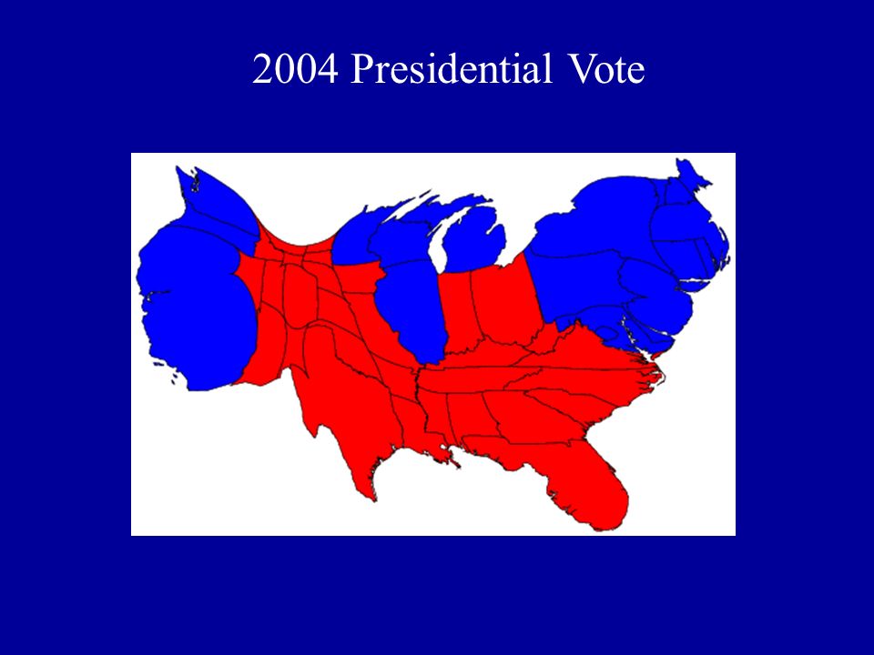
2004 Presidential Vote

Similar presentations


 But common defiance of outsiders.>")


