Download presentation
Presentation is loading. Please wait.

1
Chapter 1 Essentials of Geography
Robert W. Christopherson Charlie Thomsen

2
Essentials of Geography
The Science of Geography Earth Systems Concepts Location and Time on Earth Maps, Scales, Legend, and Projections Remote Sensing and GIS

3
The Science of Geography
Geography – from geo “Earth” and graphein “to write” Geography is a method, not a body of knowledge holistic eclectic Geographers use spatial analysis and earth system approaches

4
Geography Is The science that studies the relationships among
natural systems geographic areas society cultural activities and the interdependence of all of these over space

5
Physical Geography Is The spatial analysis of all the physical elements and processes that make up the environment

6
Figure 1.2

7
Scientific Method Figure FS 1.1.1

8
Earth Systems Concepts
Open systems (with input and output from outside of the system) Closed systems (no input or output) System feedback (interactions among components of a system) System equilibrium (static status; balanced)
 Closed systems (no input or output) System feedback (interactions among components of a system) System equilibrium (static status; balanced)")
9
Example Figure 1.3

10
Earth’s Four Spheres Figure 1.8

11
Earth’s Dimensions Figure 1.9

12
Location and Time on Earth
Latitude-angular distance from the equator Longitude-angular distance from the Prime meridian Great circles-any cuts that go through the center of the earth Prime Meridian-0 longitude Standard time

13
Great Circles and Small Circles (cuts not go through center)
Figure 1.14

14
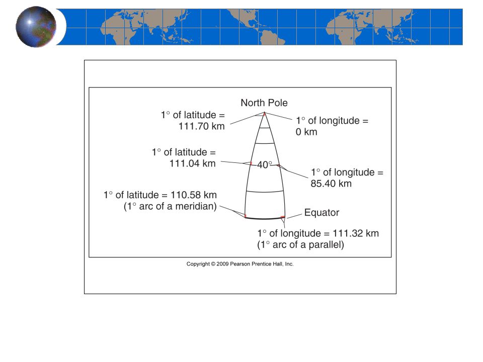
Latitude-90S to 90N marked by parallels (parallel to equator)
Each degree of latitude has the same length anywhere on the earth Figure 1.11

15
Latitudinal Geographic Zones
Figure 1.12

16
Longitude-180E to 180W marked by meridians
The length of each degree longitude decreases with latitude Figure 1.13

18
Degree conversion 1 º=60’ 1’=60’’ True or false 91º35’0’’N

19
Characteristics A great Circle:
Marks the shorted distance between 2 points on the earth’s surface All meridians are part of a great circle A Small circle: All parallels, except for the equator are part of a small circle.

20
Time zone 1 hours time zone = 360º/24 hours=15ºlongitude
Prime median: Royal Observatory at Greenwich in England (0º longitude) International Date Line: 180ºE/W
 International Date Line: 180ºE/W.")
21
Prime Meridian and Standard Time
Figure 1.17

22
Time zone If you travel from north America to Asia across the International Dateline You skip one day If you travel from Asia to North America across the International Dateline, You repeat one day

23
Maps, Scales, and Projections
Map – a generalized view of an area, as seen from above and reduced in size Scale – ratio of map units to ground units Projection – process of transforming spherical Earth to flat map

24
Properties of a globe Parallels are always parallel to each other and decrease in length towards the pole Meridians converges towards pole Distance between meridians decreases towards the pole Parallels and meridians always across each other at a right angle

25
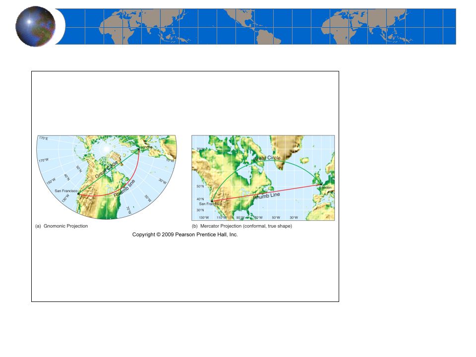
Classes of Map Projections
Figure 1.21

26
Example of Cylindrical projection-Mercator
True shape; scale varies with latitudes; Rhumb line (navigation line that across all meridians at the same angle following a compass direction): straight line of constant direction has true direction Good for tropical areas
: straight line of constant direction has true direction. Good for tropical areas.")
27
Example of Planar projection-gnomonic
Great circles are projected as a straight line; Good for polar regions

28
Conic projection Good for middle latitude regions

30
Map scales

31
Small scale and large scale map
1/100 is a large scale map compared to 1/200 A large scale map covers smaller areas but with more details (zoom in) A small scale map covers larger areas but with less details (zoom out)
 A small scale map covers larger areas but with less details (zoom out)")
32
Remote Sensing-measure without physical contact of instrument with the object
Active remote sensing-send radar waves and receive reflected waves Passive remote sensing-received radiation

33
Active and Passive Remote Sensing
Figure 1.25

34
Geographic Information Systems (GIS)
GIS systems combine spatial and attribute data Maps can contain multiple data layers: Physical features Cultural features Layers can be added to create composite overlay

35
GIS System Model Figure 1.29

Similar presentations