Download presentation
Presentation is loading. Please wait.

1
LESSONS LEARNED FROM PAST NOTABLE DISASTERS INDIA PART 1: FLOODS (NOTE: FLOODS ALSO TRIGGER LANDSLIDES) Walter Hays, Global Alliance for Disaster Reduction, Vienna, Virginia, USA
 Walter Hays, Global Alliance for Disaster Reduction, Vienna, Virginia, USA")
2
INDIA

3
NATURAL AND TECH. HAZARDS THAT HAVE CAUSED DISASTERS IN INDIA FLOODS (LANDSLIDES) SEVERE WINDSTORMS EARTHQUAKES POWER BLACKOUTS ENVIRONMENTAL CHANGE GLOBAL CLIMATE CHANGE HIGH BENEFIT/COST FROM BECOMING DISASTER RESILIENT GOAL: PROTECT PEOPLE AND COMMUNITIES
 SEVERE WINDSTORMS EARTHQUAKES POWER BLACKOUTS ENVIRONMENTAL CHANGE GLOBAL CLIMATE CHANGE HIGH BENEFIT/COST FROM BECOMING DISASTER RESILIENT GOAL: PROTECT PEOPLE AND COMMUNITIES.")
4
Natural Phenomena that Cause Disasters Planet Earth’s atmospheric- hydrospheric- lithospheric interactions create situ- ations favorable for FLOODS

5
CAUSES OF NOTABLE FLOODS IN INDIA: THE ANNUAL MONSOON RAINS

6
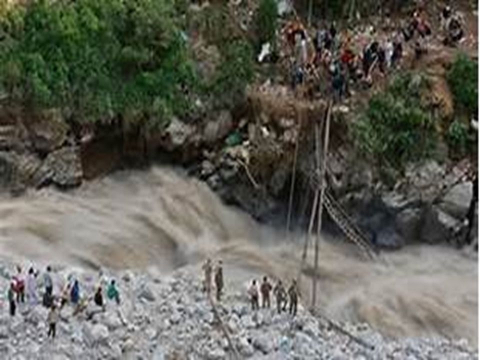
A “HIMALAYAN TSUNAMII” HIMALAYAN REGION OF NORTHEST INDIA (Floods also trigger landslides) June 24—JULY ??, 2013
 June 24—JULY , 2013")
7
Triggered by unusually heavy monsoon rains that don’t usually arrive this early in the mountainous state of Uttarakhand, which borders Nepal and China, the floods and landslides swept away buildings, roads and vehicles.

8
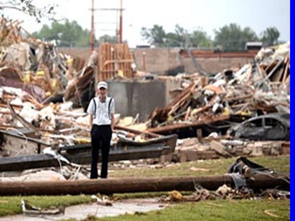
HIGH POTENTIAL LOSS EXPOSURES IN A FLOOD Entire villages: People, property, infra- structure, business enterprise, government centers, crops, wildlife, and natural resources.

9
Kedarnath, the home of a deeply revered Hindu temple visited by many pilgrims every year, experienced the maximum devastation.

10
KEDARNATH (Note: Temple in Foreground) KEDARNATH (Note: Temple in foreground)
 KEDARNATH (Note: Temple in foreground)")
15
RISHIKESH: HINDU STATUE

16
PARTS OF NEW DEHLI ALSO FLOODED

17
IMPACTS At least 1,000 feared dead 70,000 evacuated More than 50,000 people cut off by the waters

18
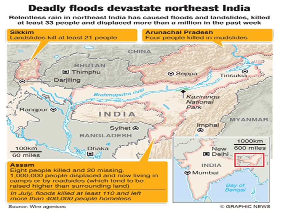
DEVASTATING FLOODS IN ASSAM STATE AND IN NORTHEST INDIA (Floods also trigger landslides) June 28—JULY 15, 2012
 June 28—JULY 15, 2012")
20
The Brahmaputra River overflowed during monsoon rains, flooding more than 2,000 villages and destroying homes in the northeast of the country

21
FLOOD: ASSAM STATE; JUNE 28, 2012

22
WILD BUFFALO GOING TO HIGHER GROUND; JUNE 28

23
STRANDED IN NAELENI VILLAGE: JUNE 28

24
STRANDED

25
SOME OF THE 500,000 EVACUEES: JUNE 29

26
ELDERLY AND YOUNG EVACUEES: JUNE 29

27
HOMELESS BULUT VILLAGE FAMILY: JUNE 30

28
PUMPING DRINKING WATER: BULUT VILLAGE; JUNE 30

29
2012: RECORD BREAKING IMPACTS Ninety-five dead Over 2 million homeless. Half a million evacuees are living in relief camps with disease prone conditions Damaging landslides hindered relief operations

30
NEEDED: FLOOD DISASTER RESILIENCE

31
INDIA’SCOMMUNITIESINDIA’SCOMMUNITIES DATA BASES AND INFORMATION HAZARDS: GROUND SHAKING GROUND FAILURE SURFACE FAULTING TECTONIC DEFORMATION TSUNAMI RUN UP AFTERSHOCKS FLOOD HAZARDS PEOPLE & BLDGS. VULNERABILITY LOCATION FLOOD RISK RISK ACCEPTABLE RISK UNACCEPTABLE RISK GOAL: FLOOD DISASTER RESILIENCE PREPAREDNESS PROTECTION EARLY WARNING EMERGENCY RESPONSE RECOVERY and RECONSTRUCTION POLICY OPTIONS

32
A FLOOD RISK ASSESSMENT HELPS GUIDE POLICY ADOPTION AND IMPLEMENTATION FOR FLOOD DISASTER RESILIENCE

33
DAMAGE FROM INUNDATION A FLOOD RISK ASSESSMENT INTEGRATES PHYSICAL EFFECTS AND SOCIETAL IMPACTS TO DETERMINE RISK EROSION, SCOUR, AND LANDSLIDES LOSS OF FUNCTION ECONOMIC LOSS RISKRISK

34
LOSS OF FUNCTION OF STRUCTURES IN FLOODPLAIN FLOODS INUNDATION INTERACTION WITH HAZARDOUS MATERIALS STRUCTURE & CONTENTS: DAMAGE FROM WATER WATER BORNE DISEASES (HEALTH PROBLEMS) EROSION AND MUDFLOWS CONTAMINATION OF GROUND WATER CAUSES OF RISK DISASTER LABORATORIES
 EROSION AND MUDFLOWS CONTAMINATION OF GROUND WATER CAUSES OF RISK DISASTER LABORATORIES")
35
FLOOD DISASTER RISKS LOSS OF FUNCTION OF BUILDINGS AND INFRASTRUCTURE, RELEASE OF HAZARDOUS MATERIALS, DAMAGE TO CONTENTS, TRANSPORTATION OF DEBRIS, AUTOS, AND HOUSES, ENVIRONMENTAL DEAD ZONES, AND WATER BORNE DISEASES

36
A RISK ASSESSMENT A risk assessment involves the probabilistic integration of: The hazard (e.g., floods) and their potential disaster agents (inundation, erosion, etc) that are directly related to the location of the community and what happens in the regional water cycle.
 and their potential disaster agents (inundation, erosion, etc) that are directly related to the location of the community and what happens in the regional water cycle.")
37
RISK ASSESSMENT (Continued) The location of each element of the exposure in relation to the physical demands of the hazard (i.e., inundation, etc.)
 The location of each element of the exposure in relation to the physical demands of the hazard (i.e., inundation, etc.)")
38
RISK ASSESSMENT (Continued) The exposure (e.g., people, and elements of the community’s built environment), represents the potential loss when the natural hazard occurs.
 The exposure (e.g., people, and elements of the community’s built environment), represents the potential loss when the natural hazard occurs.")
39
RISK ASSESSMENT (Continued) The vulnerability (or fragility) of each element comprising the exposure when subjected to the potential disaster agents.
 The vulnerability (or fragility) of each element comprising the exposure when subjected to the potential disaster agents.")
40
UNDERSTANDING VULNERABILITY: THE ULTIMATE DRIVER OF RISK

41
Vulnerability: The Driver of Risk FLOOD HAZARDS EVENT VULNERABILITY PEOPLE STRUCTURES PROPERTY ENVIRONMENT INFRASTRUCTURE EXPOSURE EXPECTED LOSS

42
An element’s vulnerability (fragility) is the result of a community’s actions or of nature’s actions that change some part of the regional water cycle (e.g., precipitation, storage, runoff, transpiration, evaporation).
 is the result of a community’s actions or of nature’s actions that change some part of the regional water cycle (e.g., precipitation, storage, runoff, transpiration, evaporation).")
43
WHAT INCREASES VULNERABILITY MANKIND’S ACTIONS AND NATURE ITSELF CAN CHANGE THE VULNERABILITY OF ELEMENTS AT RISK TO A FLOOD, A PART OF THE REGIONAL WATER CYCLE

44
MANKIND’S CONTRIBUTION An element’s vulnerability (fragility) is the result of flaws that enter during the planning, location, siting, design, and construction of a community’s buildings and infrastructure.
 is the result of flaws that enter during the planning, location, siting, design, and construction of a community’s buildings and infrastructure.")
45
MANKIND’S ACTIONS THAT CHANGE SOME PART OF THE WATER CYCLE Urban development or industrial development in areas that were formerly wetlands. Locating buildings and infrastructure in a river floodplain.

46
MANKIND’S ACTIONS THAT CHANGE SOME PART OF THE WATER CYCLE Actions that increase or decrease river gradients (deforestation, dams, etc). Actions that change the runoff rate or pattern (e.g., the city’s concrete footprint )
.")
47
NATURE’S ACTIONS THAT CHANGE THE WATER CYCLE A flash flood. Ice jams/ice dams on the river Rapid melt of snow and ice Extreme or prolonged precipitation caused by stalled low-pressure weather systems.

48
REQUIRED INFORMATION FOR A COMPREHENSIVE VULNERABILITY ASSESSMENT

49
REQUIRED INFORMATION Physical characteristics of the regional water cycle and drainage system. Physical characteristics of each river system, its tributaries, and its floodplains.

50
REQUIRED INFORMATION Physical characteristics of catchment basins, reservoirs, and wetlands in the region. Physical characteristics of dikes, levees, and dams controlling water discharge and flooding potential in the region.

51
REQUIRED INFORMATION The hazardous materials and other elements located in the floodplain.

52
LOSS OF FUNCTION OF STRUCTURES IN FLOODPLAIN FLOODS INUNDATION INTERACTION WITH HAZARDOUS MATERIALS STRUCTURAL/CONTENTS DAMAGE FROM WATER WATER BORNE DISEASES (HEALTH PROBLEMS) EROSION AND MUDFLOWS CONTAMINATION OF GROUND WATER CAUSES OF DISASTER CASE HISTORIES
 EROSION AND MUDFLOWS CONTAMINATION OF GROUND WATER CAUSES OF DISASTER CASE HISTORIES")
53
A DISASTER is --- --- the set of failures that overwhelm the capability of a community to respond without external help when three continuums: 1) people, 2) community (i.e., a set of habitats, livelihoods, and social constructs), and 3) complex events (e.g., floods, earthquakes,…) intersect at a point in space and time.
 people, 2) community (i.e., a set of habitats, livelihoods, and social constructs), and 3) complex events (e.g., floods, earthquakes,…) intersect at a point in space and time.")
54
Disasters are caused by s ingle- or multiple-event natural hazards that, (for various reasons), cause extreme levels of mortality, morbidity, homelessness, joblessness, economic losses, or environmental impacts.
, cause extreme levels of mortality, morbidity, homelessness, joblessness, economic losses, or environmental impacts.")
55
THE REASONS ARE... When it does happen, the functions of the community’s buildings and infrastructure can be LOST for long periods.

56
THE REASONS ARE... The community is UN- PREPARED for what will likely happen, not to mention the low-probability of occurrence— high-probability of adverse consequences event.

57
THE REASONS ARE... The community has NO DISASTER PLANNING SCENARIO or WARNING SYSTEM in place as a strategic framework for early threat identification and coordinated local, national, regional, and international countermeasures.

58
THE REASONS ARE... The community LACKS THE CAPACITY TO RESPOND in a timely and effective manner to the full spectrum of expected and unexpected emergency situations.

59
THE REASONS ARE... The community is INEFFICIENT during recovery and reconstruction because it HAS NOT LEARNED from either the current experience or the cumulative prior experiences.

60
POLICY ADOPTION RISK ASSESSMENT VULNERABILITYVULNERABILITY EXPOSUREEXPOSURE EVENTEVENT POLICY ASSESSMENT COSTCOST BENEFITBENEFIT CONSEQUENCESCONSEQUENCES MOVING TOWARDS FLOOD DISASTER RESILIENCE FLOODSFLOODS EXPECTED LOSS

61
LESSONS LEARNED ABOUT DISASTER RESILIENCE ALL FLOODS PREPAREDNES FOR THE EXPECTED AND UNEXPECTED IS ESSENTIAL FOR DISASTER RESILIENCE

62
LESSONS LEARNED ABOUT DISASTER RESILIENCE ALL FLOODS EARLY WARN- ING (THE ISS) AND EVACU- ATION ARE ESSENTIAL FOR DISASTER RESILIENCE
 AND EVACU- ATION ARE ESSENTIAL FOR DISASTER RESILIENCE")
63
LESSONS LEARNED ABOUT DISASTER RESILIENCE ALL FLOODS TIMELY EMERGENCY RESPONSE IS ESSENTIAL FOR DISASTER RESILIENCE

64
LESSONS LEARNED ABOUT DISASTER RESILIENCE ALL FLOODS RECOVERY AND RECON- STRUCTION USUALLY TAKES LONG- ER THAN THOUGHT.

Similar presentations


, AFTERSHOCKS.>")
 Walter Hays, Global.>")


