Download presentation
Presentation is loading. Please wait.

1
The Physical Geography of the United States and Canada
Chapter 5: Section 1 The Land

2
I. Landforms

3
Western Mountains Mt. McKinley (20,320 ft) – Alaska Range
Rocky Mountains (14,000 ft) – Pacific Range Stretch over 3,000 miles
 – Pacific Range. Stretch over 3,000 miles.")
4
Plateaus Death Valley (lowest place in the United States)
Grand Canyon (6,000 ft deep)
")
5
Interior Landforms East of the Rockies, the land falls and flattens into the Great Plains, which extend across the center of North America.

6
Eastern Mountains and Lowlands
Appalachian Mountains (extend 1,500 miles) Oldest mountain chain in North America The Canadian Shield
 Oldest mountain chain in North America. The Canadian Shield.")
7
Islands The Hawaiian islands Greenland Volcanic mountaintops
World’s largest island, is just off the coast of Canada’s Ellesmere Island.

8
II. A Fortune in Water

9
Rivers from the Rockies
The high ridge of the Rockies is called the Continental Divide. Water flows west of the Divide toward the Pacific Ocean and east of the Divide into the Mississippi River and the Gulf of Mexico.

10
The Mighty Mississippi
Mississippi River (2,350 miles) Minnesota – Gulf of Mexico Drains 31 U.S. states & 2 Canadian Provinces
 Minnesota – Gulf of Mexico. Drains 31 U.S. states & 2 Canadian Provinces.")
11
Eastern Rivers St. Lawrence River
One of Canada’s most important rivers Helps form the U.S. – Canada border

12
Eastern Rivers Niagara River Home of Niagara Falls

13
From Glaciers to Lakes Glacial dams created Canada’s Great Bear Lake and Great Slave Lake.

14
From Glaciers to Lakes The Great Lakes- Superior, Erie, Michigan, Ontario and Huron- are basins created by glacial activity.

15
St. Lawrence Seaway System
Why is the St. Lawrence Seaway System important to the U.S. & Canada?

16
III. Natural Resources

17
Fuels An abundance of resources, such as fossil fuels and minerals, has contributed to the prosperity of the United States and Canada. Canada is the 6th largest oil producer in the world United States is the 3rd largest oil producer in the world

18
Minerals Gold, silver, and copper are found in the Rocky Mountains. Nickel and iron are mined in parts of the Canadian Shield. Deposits of low-grade iron ore exist in northern Minnesota and Michigan. Canada supplies much of the world’s potash (potassium), copper, and silver.
, copper, and silver.")
19
Timber Today forests cover less than 50 percent of Canada and just 30 percent of the United States. Commercial loggers face the challenge of harvesting trees while preserving the remaining forests.

20
Fishing The coastal waters of the Atlantic and Pacific Oceans and the Gulf of Mexico are important sources of fish and other sea animals. Because of over-fishing, however, the Grand Banks, off Canada’s southeast coast, are now off limits to cod fishers.

21
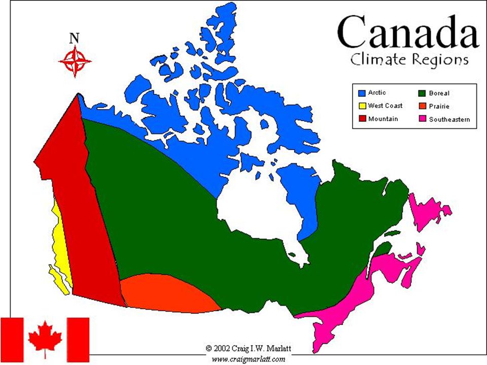
The Physical Geography of the United States and Canada
Chapter 5: Section 2 Climate and Vegetation

22
I. A Varied Region

23
A Varied Region 2/3 of Canada and the U.S. state of Alaska experience long, cold winters and brief, mild summers. Most of the continental United States and the southern one-third of Canada enjoy temperate climates, depending on elevation. Hawaii, in the South Pacific, has a tropical climate.

26
II. Northern Climates

27
Northern Climates Large parts of Canada and Alaska lie in a sub-arctic climate zone with very cold winters and extensive coniferous forests Winter temperatures can fall as low as -70 degrees.

28
Northern Climates Bitter winters and cool summers in the tundra along the Arctic coastline make the area unsuitable for most plants or people. Greenland boasts only a few ice-free areas with some extremely hardy trees.

29
III. Western Climates

30
Western Climates A marine west coast climate brings nearly 100 inches of rainfall every year to the Pacific coast from California to southern Alaska. This amount of precipitation, combined with cool temperatures, is ideal for coniferous forests, ferns, and mosses.

31
Highland Climate Elevation gives the higher reaches of the Rocky Mountains and Pacific Ranges a highlands climate. (Cool to Cold)
 .")
32
IV. Interior Climates

33
Prairies Prairies or naturally treeless expanses of grasses, spread across North America’s mid-section.

34
V. Eastern Climates

35
Eastern Climates Southeastern United States, Humid Subtropical Climate
Mild Winters, Long muggy summers Much of the original deciduous forest has been cleared for agriculture. Wetlands and swamps shelter a great variety of plants and animals. Every summer, the region prepares for hurricanes.

36
Eastern Climates Northeastern United States & Southeastern Canada
Humid Continental Climate Deciduous & Mixed Forest Winter Blizzards.

37
VI. Tropical Climates

38
Tropical Climates Hawaii, Puerto Rico, and the southern tip of Florida have tropical climates. Southern Florida has a tropical savanna area, and both Hawaii and Puerto Rico have a tropical rain forests.

Similar presentations