Download presentation
Presentation is loading. Please wait.

1
Lynne Hehr, Director, STEM Center for Math and Science Education and Arkansas NASA Resource Center, University of Arkansas lhehr@uark.edu John Hehr, Professor, Department of Geosciences, University of Arkansas jghehr@uark.edu http://cmase.uark.edu > Lynne’s Wiki

8
become familiar with the Köppen-Geiger Climate Classification system understand that climates can be broadly classified using a system based on specific variables: air temperature and precipitation.

9
calculate simple statistics and analyze a long-term (30 year) temperature and precipitation dataset explore the relationship between temperature and precipitation to determine the climate classification for their location
 temperature and precipitation dataset explore the relationship between temperature and precipitation to determine the climate classification for their location")
10
average of the day-to-day weather over a long duration generally refers to 30 years or more temperature and precipitation are extremely important

11
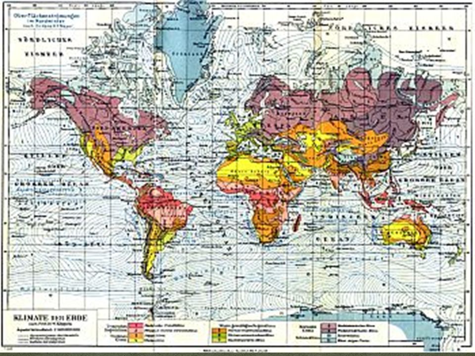
provides understanding that temperature and precipitation are both important to climate developed by Wladimir Köppen (1918) for world climate types using annual and seasonal patterns of temperature and precipitation as well as vegetation types updated in 1954 by Rudolf Geiger making it available as a world map is widely used today and known as the Köppen- Geiger Climate Classification system identifies 31 different climatic regions
 for world climate types using annual and seasonal patterns of temperature and precipitation as well as vegetation types updated in 1954 by Rudolf Geiger making it available as a world map is widely used today and known as the Köppen- Geiger Climate Classification system identifies 31 different climatic regions")
12
Equatorial (A) Arid (B) Warm Temperate (C) Snow (D) Polar (E) Each climate type can be further classified by precipitation and temperature conditions, resulting in in 31 different climate classifications.
 Arid (B) Warm Temperate (C) Snow (D) Polar (E) Each climate type can be further classified by precipitation and temperature conditions, resulting in in 31 different climate classifications.")
13
5 major climate types: A, B, C, D and E

14
Use the World Map as reference. City, CountryClimate Type Anchorage, Alaska USA Bangalore, India Bangkok, Thailand Cairo, Egypt Kiev, Ukraine London, England New Delhi, India Riyadh, Saudi Arabia Tokyo, Japan

18
MonthMean Air Temperature ( °C) Monthly Accumulated Precipitation (mm) January13.5318.58 February16.9821.53 March22.5222.78 April28.8810.47 May32.3336.61 June32.7284.02 July30.87184.49 August29.99190.25 September29.06115.45 October25.3212.59 November19.543.97 December 14.659.42
 Monthly Accumulated Precipitation (mm) January February March April May June July August September October November December")
19
Calculations will be made based on long-term (30 Year) data from New Delhi, Delhi, India. Task 2: Calculate the annual temperature (T ann ) by adding up the monthly mean temperature values and dividing by 12 (months in a year). Put this answer in Table 2A. Task 3: Record the coldest month’s temperature (T min ) and the warmest month’s temperature (T max ) in Table 2A. Task 4: Add up the monthly mean precipitation values to find the accumulated annual precipitation (P ann ). Task 5: Using either Table 1 or the Climograph in Figure 2, determine when precipitation falls and calculate the Precipitation Threshold (P th ). Complete Table 2A. The Precipitation Threshold (Pth) determines the relationship between precipitation and evaporation also known as the dryness index and is dependent upon when precipitation falls during the year.
 by adding up the monthly mean temperature values and dividing by 12 (months in a year). Put this answer in Table 2A. Task 3: Record the coldest month’s temperature (T min ) and the warmest month’s temperature (T max ) in Table 2A. Task 4: Add up the monthly mean precipitation values to find the accumulated annual precipitation (P ann ). Task 5: Using either Table 1 or the Climograph in Figure 2, determine when precipitation falls and calculate the Precipitation Threshold (P th ). Complete Table 2A. The Precipitation Threshold (Pth) determines the relationship between precipitation and evaporation also known as the dryness index and is dependent upon when precipitation falls during the year..")
20
Use the Koppen-Geiger Climate Classification key T ann Annual Air Temperature (°C) ? T min Air Temperature of Coldest Month (°C) ? T max Air Temperature of Warmest Month (°C) ? P ann Accumulated Annual Precipitation (mm) ? P th Precipitation Threshold (mm) ?
 . T max Air Temperature of Warmest Month (°C) . P ann Accumulated Annual Precipitation (mm) . P th Precipitation Threshold (mm) .")
21
Using Part 1 of the Köppen-Geiger Climate Classification key determine the major climate classification – Equatorial (A) Arid (B) Warm Temperate (C) Snow (D) or Polar (E) New Delhi’s Main Climate Type is:
 Arid (B) Warm Temperate (C) Snow (D) or Polar (E) New Delhi’s Main Climate Type is:")
22
Step 2: 2 nd letter : sub-classification uses the relationship between when precipitation falls and how much precipitation falls is important. (Use the classification key) 3 rd letter: Some climate zones have a third sub- classification based on temperature.
 3 rd letter: Some climate zones have a third sub- classification based on temperature..")
23
T min Precipitation in the driest month (mm) T wmax Precipitation in the wettest winter* month (mm) T wmin Precipitation in the driest winter* month (mm) P smax Precipitation in the wettest summer* month (mm) P smin Precipitation in the driest summer* month (mm) Are there at least 4 months with Air Temperature greater than 10° C (yes/no) Note: Winter and Summer are defined as half-years within this classification system. Therefore, winter is considered to be “low-sun” months (November through March in the Northern Hemisphere, or April through September in the Southern Hemisphere) and summer is considered to be “high-sun“ months (April through September in the Northern Hemisphere, or October through March in the Southern Hemisphere)
 and summer is considered to be high-sun months (April through September in the Northern Hemisphere, or October through March in the Southern Hemisphere).")
24
New Delhi’s main climate type is: New Delhi’s first sub-climate classification is: Second sub-climate classification is: Köppen-Geiger classification is:

25
How did the calculated classification compare to your original predictions for New Delhi?

26
Step 1: (Using 30 year NCDC World Map) Task 1: Using the city data provided, produce a climograph of monthly mean air temperature and precipitation. Task 2: Discuss the description of the climate of this location.? Task 3: Classify the climate of the location.

31
Go to Polar Go to Arid Go to Equatorial Go to Warm Temperate Go to Snow Skip to descriptions

32
Back

35
Go to 5 Back

37
Go to 5to Back

Similar presentations


, Łódź, 10-14 September 2012 Rajmund Przybylak, Aleksandra Pospieszyńska.>")


