Download presentation
Presentation is loading. Please wait.

1
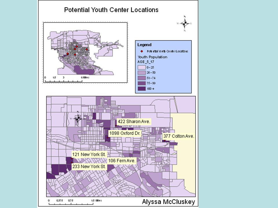
Tips for Map Due for Lab 1 Complete Exercise (Find Potential Youth Center Locations) through step 6. You should now have the potential youth center locations. Do NOT apply the map template. Insert – New Data Frame Copy and Paste Layers in the New Data Frame Use one Data Frame for a Small Map (zoomed out to full extent) and one Data Frame for a Large Map (zoomed in to potential youth center locations). Switch to the Layout View Create your map with Title, Data Frames, Legend, Scale Bars, Name, North Arrow Another tip is to remember going to Layer Properties (Rt-Click on the Layer) and choose the Labels tab to edit the labels (size, appearance, etc.) (also change layer name)
 and one Data Frame for a Large Map (zoomed in to potential youth center locations). Switch to the Layout View Create your map with Title, Data Frames, Legend, Scale Bars, Name, North Arrow Another tip is to remember going to Layer Properties (Rt-Click on the Layer) and choose the Labels tab to edit the labels (size, appearance, etc.) (also change layer name).")
4
If you use TA Computers Need to update the data to version 9.2 using ArcCatalog

5
If you use TA Computers

6
Learning ArcGIS Spatial Analyst Topics Covered in Module 1 CVEN 2012 – Geomatics University of Colorado – Boulder April 2006 Alyssa McCluskey

7
Topics Covered in Lab Exercise understand how ArcGIS Spatial Analyst fits into the geoprocessing framework set up an analysis environment run Spatial Analyst operations using a tool dialog, the command line, and a model convert between feature and raster data reclassify data

8
Why do we need rasters (grids)? Deal with geographic objects that are distributed continuously across a surface. Temperature, rainfall, soil acidity, elevation, land cover Distance to nearest hospital, noise levels While they don’t have a ‘shape’ they do have a value at any given location.

9
Geoprocessing A GIS operation used to manipulate GIS data. A typical geoprocessing operation takes an input dataset, performs an operation on that dataset, and returns the result of the operation as an output dataset. Common geoprocessing operations include geographic feature overlay, feature selection and analysis, topology processing, raster processing, and data conversion. Geoprocessing allows for definition, management, and analysis of information used to form decisions.

10
Geoprocessing Examples From Elevation Data –Create Slope Data, Hillshade Data, Aspect Data Converting to/from Raster Data

11
Performing Geoprocessing You can use a tool's dialog, the command line, a model, or a script, depending on your needs or preferences.

12
Performing Geoprocessing The ArcGIS geoprocessor has one integrated dialog that sets processing environments for all outputs; shapefiles, rasters, geodatabase feature classes, and so forth.

13
Setting Default Environment Setting

14
Input Raster Output ExtentOutput Cell Size MaskOutput Raster Analysis Properties

15
Set Geoprocessing Environment Or access from Tools - Options

16
Set Geoprocessing Environment

18
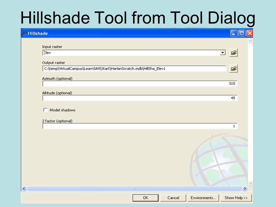
Hillshade Tool The Hillshade tool creates a shaded relief raster from a raster. Draws shadows on a map to simulate the effect of the sun's rays over the varied terrain of the land. The hypothetical illumination of a surface according to a specified azimuth and altitude for the sun. Hillshading creates a three-dimensional effect that provides a sense of visual relief for cartography, and a relative measure of incident light for analysis.

19
Run Spatial Analyst using TOOL DIALOGUE

20
Hillshade Tool from Tool Dialog

22
Hillshade Tool Result Elevation Data Hillshade Result

23
SLOPE The incline, or steepness, of a surface. Slope is the rate of maximum change in z-value from each cell. Slope can be measured in degrees from horizontal (0–90), or percent slope (which is the rise divided by the run, multiplied by 100). A slope of 45 degrees equals 100 percent slope. As slope angle approaches vertical (90 degrees), the percent slope approaches infinity. The slope for a cell in a raster is the steepest slope of a plane defined by the cell and its eight surrounding neighbors.
, or percent slope (which is the rise divided by the run, multiplied by 100). A slope of 45 degrees equals 100 percent slope. As slope angle approaches vertical (90 degrees), the percent slope approaches infinity. The slope for a cell in a raster is the steepest slope of a plane defined by the cell and its eight surrounding neighbors..")
24
Run Spatial Analyst using COMMAND LINE

25
Using Command Line

26
SLOPE Command Slope_sa {DEGREE | PERCENT_RISE} {z_factor}

27
Slope Elevation Data Slope

28
Run Spatial Analyst using MODEL BUILDING

29
Model Building – Add Toolbox for New Model

30
Model Building

31
DRAG AND DROP

32
Model Building DRAG AND DROP

33
Model Building DRAG AND DROP

34
Model Building DRAG AND DROP Note: Unshaded

35
Model Building Auto Layout Add Connection

36
Model Building - Execute Run

37
Model Building - Execute Drop Shadows = Model has been executed

38
Model Building Adding Results to Display Adds output as layer

39
ASPECT The compass direction that a topographic slope faces, usually measured in degrees from north. Aspect can be generated from continuous elevation surfaces. The conceptual center of a projection system.

40
Aspect Tool Result Elevation Data Aspect Result

41
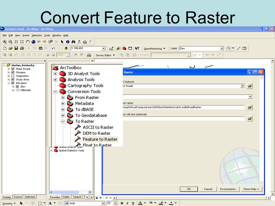
Convert Feature to/from Raster Convert Feature to Raster You can convert point, line, and polygon features from any type of source file to a raster using either string and numeric attribute fields. If more than one point is found in a cell, the cell is given the value of the first point it encounters. When you convert polygons, Spatial Analyst assigns each cell the value of the polygon that contains the centroid of the cell. Convert Raster to Feature The point coordinates are those of the centroid of the cell.

42
Convert Feature to Raster

44
Attribute from Road Layer

45
Convert Feature to Raster

46
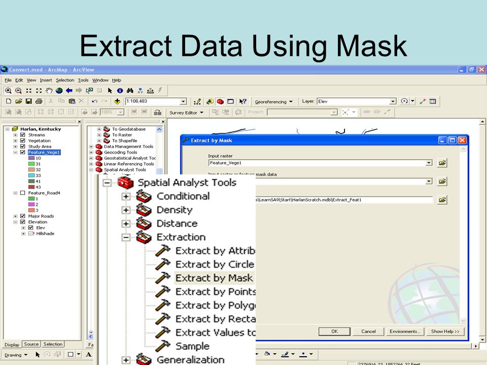
Extract Data by Using a Mask Extracts the cells of a raster that correspond to the areas defined by a mask

47
Extract Data Using Mask

51
Reclassifying Reclassification is the process of reassigning a value, a range of values, or a list of values in a raster to new output values. One reason is to set specific values to NoData to exclude them from analysis. Still another reason is to assign values of preference, priority, sensitivity, or similar criteria to a raster.

52
Reclassify Continuous Data

53
Reclassify

55
Classification

56
Different Classifications Natural Break: Manually partitions data into classes based on natural groups in the data distribution. Natural breaks occur in the histogram at the low points of valleys. Equal-Interval: Divides a set of attribute values into groups that contain an equal range of values. Quantile: Distributes a set of values into groups that contain an equal number of values.

57
Different Classifications Natural Breaks Quantile Equal-Interval

58
Reclassify Vegetation Rank vegetation based on tolerance to drought (low value = high tolerance)
")
59
Reclassify Vegetation

62
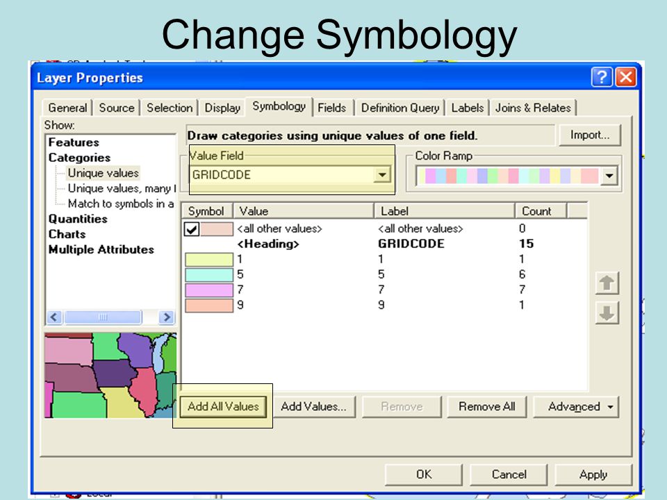
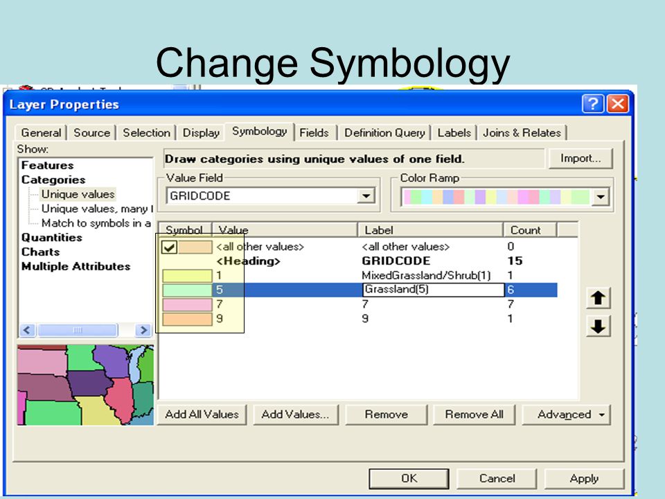
Change Symbology

63
Edit Layer Title

64
Convert Raster to Vector

66
Raster Polygon

67
Change Symbology Double click on layer or go to layer properties

68
Change Symbology

71
Double click on symbol, choose more symbols

72
Change Symbology

73
Create Map

74
Completing LAB 2 Do NOT follow directions to upgrade the data (we are using 9.1) unless in TA room Create a Map of the Reclassified Vegetation (Drought Sensitivity) Vector Data – use nice symbology to make it clear and make a nice map (email or print) Email or print Spatial Analysis Module1 Completion Certificate Due Friday April 27 th
 unless in TA room Create a Map of the Reclassified Vegetation (Drought Sensitivity) Vector Data – use nice symbology to make it clear and make a nice map ( or print) or print Spatial Analysis Module1 Completion Certificate Due Friday April 27 th")
75
Next Class Working with Survey Data in ArcGIS

Similar presentations


; Proximity (raster) 5.Filtering.>")


