Download presentation
Presentation is loading. Please wait.

1
All the wind

2
Today Homework in Friction wind Observing the wind Some special winds

3
All the wind Friction Resultant wind –At the surface –Above our heads

4
Friction Wind Winds near the surface are influenced by the ground. This influence is in the form of friction. Friction acts to retard the motion of the wind -- it is always in the direction opposite the wind velocity. H L PGFCoCo V FrFr Friction acts to oppose the flow of the air. The air will slow down, reducing the Coriolis force. This results in an imbalance of forces.

5
Friction Force Friction (F r ): –Results from rubbing of air molecules against ground, trees, buildings, you. –Greatest near and right at the surface. Usually confined to lowest 1000m (3000 ft). –Friction retards motion, i.e.., acts backwards. –Friction force increases with wind speed. V FrFr
. –Friction retards motion, i.e.., acts backwards. –Friction force increases with wind speed. V FrFr.")
6
Friction Wind The atmosphere adjusts, to regain a balance, by turning the wind toward low pressure. H L PGF CoCo V FrFr A new balance is achieved when the sum of the Friction and Coriolis forces balance the horizontal pressure gradient force.

7
Friction Wind L Winds are directed toward low pressure. But, the air must go somewhere! L Directional convergence Lifting of air “Bad” Weather Cyclonic Flow

8
Friction Wind Winds are directed toward low pressure. But, the air must go somewhere! Directional divergence Sinking of air “Good” Weather Anticyclonic Flow H H

9
Surface & 500 mb Maps Surface maps chart pressure contours, highs and lows, and wind direction. Winds blow clockwise around highs, called anticyclones. 500 mb maps reveal patterns that on average are 5600 m above the surface, where westerly winds rise and fall across ridges and troughs. Figure 9.15A

10
Wind Speed & Pressure Contours Just as a river speeds and slows when its banks narrow and expand, geostrophic winds blowing within pressure contours speed as contour intervals narrow, and slow as contour intervals widen. Figure 9.24

11
Meridional & Zonal Flow Wind direction and speed are indicated by lines, barbs, and flags, and appear as an archer's arrow. Upper level winds that travel a north-south path are meridional, and those traveling a west-east path are zonal. Figure 9.28

12
Sensing Highs & Lows The location of high and low pressure centers are estimated by detecting surface wind direction and noting pressure, Coriolis, and friction forces. This figure illustrates the procedure when standing aloft and at the surface. Figure 9.32A

13
Vertical Air Motion Winds converging into a low pressure center generate upward winds that remove the accumulating air molecules. These updrafts may cause cloud formation. Likewise, diverging air molecules from a high pressure area are replenished by downward winds. Figure 9.33

14
Wind Instruments Figure 10.17 Wind vanes point into the wind, or toward its origin, while revolutions of a cup anemometers record wind distance and speed. Aerovanes can measure both speed and direction. Pilot balloons observed with theodolites, infrared radiometers, and lidar are other wind detection tools. Doppler radar detects changes in wind speed within large volumes of atmosphere.The vertical profile may extend 16km, and can help identify developing storms and tornadoes. Figure 10.18

15
Special winds There are some types of wind that occur in different places that are given names The most common are downslope or Katabatic winds These are warm (dry) winds Examples are –Chinook (Foehn) winds –Santa Ana winds
 winds Examples are –Chinook (Foehn) winds –Santa Ana winds")
16
Katabatic Wind Figure 10.29 Mountain snow cover creates a thin layer of high pressure cold air that rushes into lower valleys. Elevated plateaus with snow cover may foster development of a thin layer of high pressure cold air. Pressure gradient winds are triggered due to lower pressure above the adjacent valley, pushing cold air into the lower valley.

18
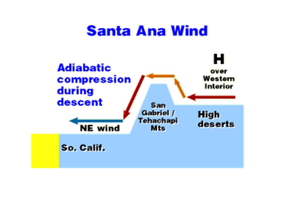
Santa Ana Winds Figure 10.32 Easterly winds that descend from southern California's elevated desert plateau are compressionally heated and lowered in humidity. Many fires have been triggered by winds of this type.

20
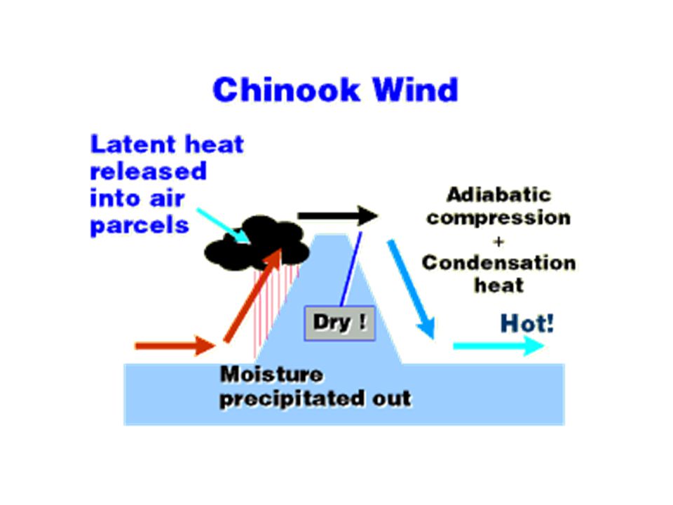
Chinook Winds Westerly winds that condense and precipitate their moisture when ascending the Rockies, and then compressionally warm and dry when descending, are described as chinook winds. Figure 10.30

21
Chinook Wall Cloud Figure 10.31 Chinook wall clouds are an indicator of their presence.

22
Summary A lot of wind Local effects Regional effects

Similar presentations