Download presentation
Presentation is loading. Please wait.

3
What is Karst? A terrain, generally underlain by carbonate rocks (limestone, dolomite), in which the topography is chiefly formed by the dissolving of rock via carbonation and which may be characterized by sinkholes, disappearing streams, subterranean drainage, and caves.
, in which the topography is chiefly formed by the dissolving of rock via carbonation and which may be characterized by sinkholes, disappearing streams, subterranean drainage, and caves..")
4
Karst terrains in the US

6
Karst landforms

7
Cockpit karst, Jamaica

8
Karst towers, China

9
Karst towers, Madagascar

10
Sinkholes Various names depending upon language, can also be known as dolines (Europe, as derived from Polish) or cenotes (Mexico). Formation – Groundwater dissolves soluble rock, creating fractures and caves – Dissolving continues to form larger caves and fractures. https://www.youtube.com/watch?v=FzPD1CGxuTI#t=15 https://www.youtube.com/watch?v=uEIW0dXXK_E

11
Solution sinkhole

13
Collapse sinkhole

14
Collapse doline with water-table lake in Gambier Karst, South Australia.

15
Karst plain, central KY

16
Uvalas and Poljes Uvalas (top) – Compound sinkholes, coalescence of many smaller sinkholes Poljes (bottom) – Broad flat alluvial floor formed from coalescence of uvalas
 – Compound sinkholes, coalescence of many smaller sinkholes Poljes (bottom) – Broad flat alluvial floor formed from coalescence of uvalas")
17
Clints and grikes Corrosive drainage along joints and cracks in the limestone can produce slabs called "clints" isolated by deep fissures called "grikes". (County Clare, northwest Ireland)
.")
18
Karren: landscape composed of clint and grike features in limestone (County Clare, northwestern Ireland, the Barrens). Karren

21
Lake Jackson, north of Tallahassee, FL

22
Lake Jackson emptied

23
When Lake Jackson’s sinks rupture and the lake water drains out, the process is referred to as a drawdown. It has occurred many times during the last century.

24
Florida sinkholes Winter Park, Florida (1981) – 100 m across – Appeared over course of a day – Water table dropped and collapse sinkhole formed – Now an urban lake https://www.youtube.com/watch?v=FzPD1CGxuTI#t=15 https://www.youtube.com/watch?v=uEIW0dXXK_E
 – 100 m across – Appeared over course of a day – Water table dropped and collapse sinkhole formed – Now an urban lake v=FzPD1CGxuTI#t=15 v=uEIW0dXXK_E")
25
Kentucky sinkholes

28
Cenotes (Yucatan, Mexico)
")
29
Blue holes 29

30
Surface and subsurface water

31
Cave formation and speleothems

32
Aquifers Large body of permeable material where groundwater is present in the saturated zone. Good aquifers have high permeability (ease with which water can move through a porous rock) arising from – Poorly cemented sands, gravels, and sandstones – Karstic dissolution – Highly fractured rock.
 arising from – Poorly cemented sands, gravels, and sandstones – Karstic dissolution – Highly fractured rock..")
33
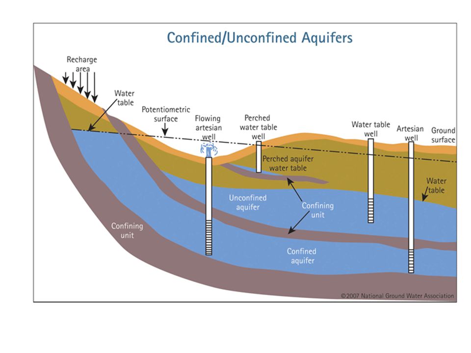
Aquifer types Confined aquifers –Under pressure due to confining layers above and below. –Water will freely rise into wells drilled into them (artesian wells) to a level known as the potentiometric surface –To draw water above this surface requires pumping Unconfined aquifers –Have confining layers only at the base –Not under pressure. –Water levels rise and fall with the water table.
 to a level known as the potentiometric surface –To draw water above this surface requires pumping Unconfined aquifers –Have confining layers only at the base –Not under pressure. –Water levels rise and fall with the water table..")
36
Perched water tables

37
Human use of aquifers Excellent sources of water for human usage “Fossil” water in aquifers can be depleted – Ogallala Aquifer – Florida Aquifer

38
2010

Similar presentations


 “A terrain with distinctive landforms and drainage arising from greater rock solubility in natural water that is found.>")