Download presentation
Presentation is loading. Please wait.

1
Open GIS Software in Brazil: Producing Open Source in Developing Nations Gilberto Câmara Director for Earth Observation National Institute for Space Research Brazil

2
The issue “Developing countries and their donor partners should review policies for procurement of computer software, with a view to ensuring that options for using low-cost and/or open-source software products are properly considered and their costs and benefits carefully evaluated” (UK IPR report, 2002) Yes, but… We need much more than Linux! Who will develop the open source software we need? Can it be done in developing countries?

3
The discussion today The nature of open source software A realistic model for OS projects Spatial information technology The need for open source GIS and Remote Sensing software Developing an open source GIS in Brazil 20 years of institutional, nation-wide efforts Technology as social construction Some lessons learned How can we do OS software in the South?

4
The nature of open source projects Idealized view of OS community Network of committed individuals (“peer production”) Based on a limited number of examples Reality of software projects Problem granularity Conceptual design Degree of innovation Social context of technology
 Based on a limited number of examples Reality of software projects Problem granularity Conceptual design Degree of innovation Social context of technology")
5
Naïve view of open source projects Software Product of an individual or small group (peer-pressure) Based on a “kernel” with “plausible promise” Development network Large number of developers, single repository Open source products View as complex, innovative systems (Linux) Incentives to participate Operate at an individual level (“self-esteem”) Wild-west libertarian (“John Waynes of the modern era”)
 Based on a kernel with plausible promise Development network Large number of developers, single repository Open source products View as complex, innovative systems (Linux) Incentives to participate Operate at an individual level ( self-esteem ) Wild-west libertarian ( John Waynes of the modern era )")
6
Idealized model of OS software Networks of committed individuals

7
The reality of open source projects Problem granularity Effective peer-production requires high granularity (Benkler) Each type of software induces a breakdown strategy What works for an operating system will not work for a database! Conceptual design and Innovation Most OS software is based on established paradigms (Linux is a 1970’s design) Design is the hardest part of software (Fred Brooks) Social context of technology Software development requires closely-knit teams Software will do nothing by itself Complex software requires informed users
 Design is the hardest part of software (Fred Brooks) Social context of technology Software development requires closely-knit teams Software will do nothing by itself Complex software requires informed users.")
8
The reality of open source projects Linux model is not scalable Other types of software are less modular We need more innovation, and less “reverse-engineering” Requirements for success Long-term investment Very qualified personnel Accessible mostly to organizations, not to individuals Plausible model “Human Genome” x “John Wayne” The “Godzilla” effect (size matters)
")
9
Real-life model of OS software Networks of committed organizations

10
Spatial information technology Basis of the technology Computer representation of spatio-temporal phenomena Discrete objects (e.g., parcels) Continuous fields (e.g., topography) Uses of GIS (geographical information systems) Commercial applications Location-based services Business geographics Public good applications Urban cadastral systems Environmental protection and prediction Agriculture crop forecasting Hydrological modeling
 Continuous fields (e.g., topography) Uses of GIS (geographical information systems) Commercial applications Location-based services Business geographics Public good applications Urban cadastral systems Environmental protection and prediction Agriculture crop forecasting Hydrological modeling")
11
Knowledge gap for spatial data source: John McDonald (MDA)
")
12
Knowledge gap for spatial data Imbalance of public expenditure Governments build data-gathering satellites… ENVISAT = Us$ 1 billion EOS (Terra/Aqua) = Us$ 1 billion ….and they hope the market will do the rest Leading remote sensing software product US$25 M (gross) The model does not add up! There is not enough market to cover large R&D expenses The result is the “knowledge gap”

13
Knowledge gap for spatial data Most applications of EO data “Snapshot” paradigm Recipe analogy Take 1 image (“raw”) “Cook” the image (correction + interpretation) All “salt” (i.e., ancillary data) Serve while hot (on a “GIS plate”) But we have lots of images! Immense data archives (Terabytes of historical images) How many image database mining application we have?
 How many image database mining application we have .")
14
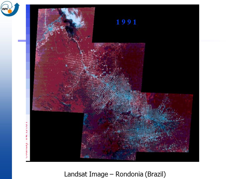
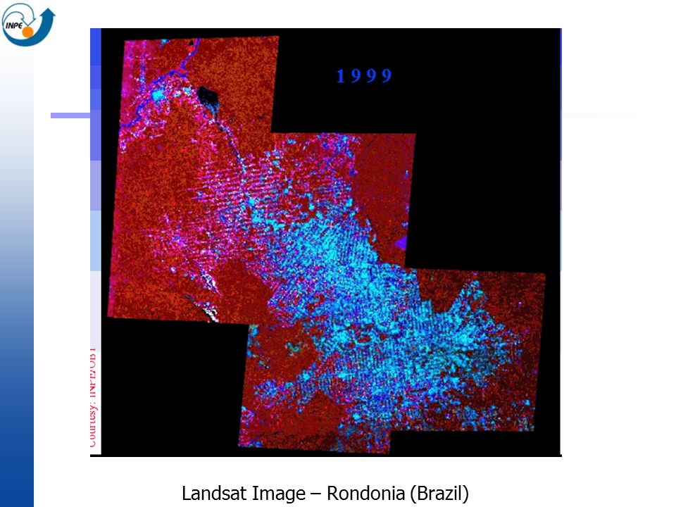
Landsat Image – Rondonia (Brazil)
")
17
Bridging the Knowledge gap “Deadlock” situation Small size of commercial IP Not enough income for R&D investment Improvements on information extraction Needed for the market to grow Making use of the deluges of data Government-funded software development Strong integration with scientific community Open Source GIS projects Provide innovative ways to use spatio-temporal data Effective means of advancing environmental applications

18
The Brazilian experience National Institute for Space Research (INPE) Space Science, Earth Observation, Meteorology and Space Engineering Staff of 1,600 (50% Master and Ph.D. degrees) GIS and Remote Sensing software development Institutional program initiated in 1984 Aims Make Brazil self-sufficient in GI technology Empower users with public-good applications Strategy Foster qualified human resources Link technology with application
 GIS and Remote Sensing software development Institutional program initiated in 1984 Aims Make Brazil self-sufficient in GI technology Empower users with public-good applications Strategy Foster qualified human resources Link technology with application.")
19
SPRING Open access image processing and GIS software. Multi-platform (Windows, Linux, Solaris) Web: http://www.dpi.inpe.br/spring (32.000 downloads)http://www.dpi.inpe.br/spring
 Web: ( downloads)")
20
SPRING Significant development effort 140 man-years (1994-present) 500,000+ lines of C++ code Designed from scratch (no reverse engineering) Innovative solutions (firsts) Object-oriented spatial data model Integration of remote sensing and GIS Window-based interface in Windows and Linux Geostatistics (kriging) functions in a GIS Region-based segmentation and classification
 500,000+ lines of C++ code Designed from scratch (no reverse engineering) Innovative solutions (firsts) Object-oriented spatial data model Integration of remote sensing and GIS Window-based interface in Windows and Linux Geostatistics (kriging) functions in a GIS Region-based segmentation and classification")
21
Technology as a social product Research system in the developed world discourages the production of training material There are good books on GIS! unfortunately, these books are in English and are expensive Need for open access of information Open access literature in local language Brazilian experience three-volume set (“Introduction to GIS”, “Spatial Analysis”, “Spatial Databases”) Application examples using SPRING: key factors in software adoption
 Application examples using SPRING: key factors in software adoption.")
22
SPRING: User adoption Universities Driving factors: documentation and examples, not price Graduate and undergrads: Geography, Earth Sciences, Social Sciences Government institutions Replace existing US-based commercial solutions Agricultural research agency (EMBRAPA) Geological Survey (CPRM) Census bureau (IBGE) Private companies Saving of licensing costs Local support and training
 Geological Survey (CPRM) Census bureau (IBGE) Private companies Saving of licensing costs Local support and training")
23
SPRING downloads (Top 20 countries)
")
24
Innovation in GIS Current generation of GIS Built on proprietary architectures Interface + functions + database = “monolithic” system Geometric data structures = archived outside of the DBMS New generation of spatial information technology All data will be handled by the database (inclusive images and maps) Users can develop customized applications (“small GIS”) They need appropriate tools!
 Users can develop customized applications ( small GIS ) They need appropriate tools!")
25
TerraLib: Open source GIS library Data management All of data (spatial + attributes) is in database Functions Spatial statistics, Image Processing, Map Algebra Innovation Based on state-of-the-art techniques Same timing as similar commercial products Web-based co-operative development http://www.terralib.org
 is in database Functions Spatial statistics, Image Processing, Map Algebra Innovation Based on state-of-the-art techniques Same timing as similar commercial products Web-based co-operative development ")
26
TerraLib applications Cadastral Mapping Improving urban management of large Brazilian cities Public Health Spatial statistical tools for epidemiology and health services Social Exclusion Indicators of social exclusion in inner- city areas Land-use change modelling Spatio-temporal models of deforestation in Amazonia Emergency action planning Oil refineries and pipelines (Petrobras)
")
27
What does it take to do it? SPRING and TerraLib project Major emphasis on “learning-by-doing” Development and Application Team Software: 40 senior programmers (10 with PhD) Applications: 30 PhDs in Earth Sciences plus students Building a resource base Graduate Programs in Computer Science and Remote Sensing SPRING and Terralib: 20 PhD thesis and 35 MsC dissertations Institutional effort Requires long-term planning and vision
 Applications: 30 PhDs in Earth Sciences plus students Building a resource base Graduate Programs in Computer Science and Remote Sensing SPRING and Terralib: 20 PhD thesis and 35 MsC dissertations Institutional effort Requires long-term planning and vision.")
28
Challenges for developing countries Need for innovative solutions Software is an enabling product Caters for specific needs of communities There are unfulfilled needs in the South (e.g. educationware) The world is getting more complex (or at least we are increasing recognizing this) We need talented people to solve difficult problems There is not enough talent in the North of the Equator! Why should government money fund open source? Only way to produce results in the South! Open source will not happen by spontaneous growth It is very expensive to conserve qualified resources It is very important to invest in qualified resources
 The world is getting more complex (or at least we are increasing recognizing this) We need talented people to solve difficult problems There is not enough talent in the North of the Equator. Why should government money fund open source. Only way to produce results in the South. Open source will not happen by spontaneous growth It is very expensive to conserve qualified resources It is very important to invest in qualified resources.")
29
Government and Job Creation Low-TechHigh-Tech FixedWaiterSurgeon MobileAssembly-line worker Software Engineer

30
Conclusions Open Source software model The Linux example is not applicable to all situations Moving from the individual level to the organization level Spatial information technology Large R&D is needed to bridge the “knowledge gap” Open source GIS software has a large role Open source projects in developing nations Combination of institutional vision, qualified personnel and strong links to user community Government-funded to be viable

Similar presentations


, Brazil Institute for Geoinformatics, University of.>")


:>")


