Download presentation
Presentation is loading. Please wait.

1
Learning Objectives Meaning of “Environmental Geology”
Scientific Method Cultural/Environmental Awareness Environmental Ethics Environmental Crisis? Sustainability Systems; Environmental Unity Uniformitarianism

2
Environmental Ethics What does this mean?
Environmental “consciousness” Existence of relationships between the physical environment and civilization Motivation for concept? e.g., “The Quiet Crisis” Land Ethic: Responsibility to the total environment as well as society Meaning / scope? Limits? Perspective

3
Environmental Crisis Meaning? Factors
Increasing demands on diminishing resources Demands accelerate as the population grows Increasing production of wastes Factors Overpopulation Urbanization Industrialization Low regard for environmental/land ethics Inadequacy of institutions to cope with environmental stresses

4
Fundamental Concepts Population Growth Sustainability Systems
Limitation of Resources Uniformitarianism Hazardous Earth Processes Geology as a Basic Environmental Science Obligation to the Future

5
Eight Fundamental Concepts
1. Overpopulation = #1 environmental problem 2. Environmental objective = sustainability 3a The earth is (essentially) a closed system with respect to materials 3b Solutions to environmental problems require understanding of feedback and rates of change in systems 4a. The earth is the only sustainable habitat we have 4b. It’s resources are limited 5. Today’s physical processes are modifying our landscape (and environment), and have operated throughout geologic time; but magnitude and frequency are subject to natural and man-induced changes Earth processes that are hazardous to people have always existed An understanding of our environment requires an understanding of the earth sciences (and related disciplines) The effects of land use tend to be cumulative. Thus, we have an obligation to those who follow us.
 a closed system with respect to materials. 3b Solutions to environmental problems require understanding of feedback and rates of change in systems. 4a. The earth is the only sustainable habitat we have. 4b. It’s resources are limited. 5. Today’s physical processes are modifying our landscape (and environment), and have operated throughout geologic time; but magnitude and frequency are subject to natural and man-induced changes. Earth processes that are hazardous to people have always existed. An understanding of our environment requires an understanding of the earth sciences (and related disciplines) The effects of land use tend to be cumulative. Thus, we have an obligation to those who follow us.")
6
Systems System: Any part of the universe selected for study
Concept of “systems” Earth as “a system” (w/ component systems): Atmosphere (air) Hydrosphere (water) Lithosphere (rock, soil) Biosphere (life) Interactions of these parts = conditions of the environment Changes in magnitude or frequency of processes in one part causes changes in other parts, e.g., ?
: Atmosphere (air) Hydrosphere (water) Lithosphere (rock, soil) Biosphere (life) Interactions of these parts = conditions of the environment. Changes in magnitude or frequency of processes in one part causes changes in other parts, e.g.,")
7
System Feedback Negative: System adjusts to changed conditions to reestablish “steady state”, e.g., river Positive: Changes in a system that cause significant modifications of a system, and result in amplification of the changes

8
Uniformitarianism “The past is the key to the present”
We can gain understanding of geologic processes, systems, etc. in the past by understanding how they work today Examples: Mountain building/topography/landscape Erosion Water cycles Climate Relationships between life & environment

9
Uniformitarianism con’t
Key concept in interpreting geologic observations, e.g., Glacial processes Marine fossils on mountain tops Volcanism elsewhere in the solar system Ore, petroleum deposits Key for using geologic knowledge to understand natural earth processes in historical and predictive modes

10
Chapter Summary Environmental Geology = ?
Consideration of time in geologic sciences Cultural basis for environmental degradation (explain) Ethical Economic Political Religious Environmental problems not confined to any one political or social system Land ethic = ? Immediate cause of environmental crisis: Overpopulation Urbanization Industrialization (what do these mean; what’s the relationship?)
 Ethical. Economic. Political. Religious. Environmental problems not confined to any one political or social system. Land ethic = Immediate cause of environmental crisis: Overpopulation. Urbanization. Industrialization. (what do these mean; what’s the relationship )")
11
Chapter Summary con’t Environmental “Problems” mean what?
Solutions to environmental problems require what? Scientific understanding (of what?) Fostering social, economic, and ethical behavior to allow implementation (Explain)
 Fostering social, economic, and ethical behavior to allow implementation (Explain)")
12
Earth Materials & Processes
Focus: Geologic materials and processes most important to the study of the environment Objectives: Acquire a basic understanding of the geologic cycle and its subcycles (tectonic, rock, hydrologic, biogeochemical) Review of some of the important mineral and rock types and their environmental significance Appreciation/significance of geologic structures Appreciation of the landforms, deposits, and environmental problems resulting from wind and glacial processes
 Review of some of the important mineral and rock types and their environmental significance. Appreciation/significance of geologic structures. Appreciation of the landforms, deposits, and environmental problems resulting from wind and glacial processes.")
13
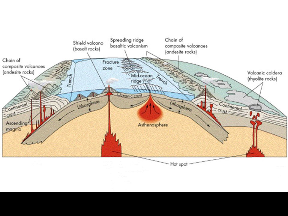
Observations/Correlations:
Types and spatial distribution of plate boundaries Correlation between plate boundaries and volcanoes (+ earthquakes)
")
14
Two Types of Crust/Lithosphere:
Oceanic (O): forms 70% of earth’s crust constitutes sea-floor bedrock; ~30 km thick made of primary volcanic “basalt”; density= Young; No old oceanic crust Continental (C): Thicker (~100 km) Composition: Less dense sediment/granite “floats” on denser mantle material Older Mantle Primary material (from which basalts are derived) Underlies crust
: forms 70% of earth’s crust. constitutes sea-floor bedrock; ~30 km thick. made of primary volcanic basalt ; density= Young; No old oceanic crust. Continental (C): Thicker (~100 km) Composition: Less dense sediment/granite. floats on denser mantle material. Older. Mantle. Primary material (from which basalts are derived) Underlies crust.")
15
Main Types of Plate Boundaries
Divergent (splitting apart) Convergent (colliding) Third Type = Transform (e.g., lateral offset)
 Convergent (colliding) Third Type = Transform (e.g., lateral offset)")
16
Types Plate Motion, Plate Boundaries, and Examples of Associated Landforms/Features
Divergent (separating): O-O sea-floor spreading/mid-ocean ridges C-C Continental “rifts”: Red Sea, Rio Grande & Mississippi river valleys, E. African (Kenyan) Rift Valley Convergent (colliding): O-O Island arc Subduction; Japan, Aleutians O-C Continental margin Subduction; Cascades, Andes C-C Continental collision; Himalayas, Alps, Appalachians Others: Obduction; Accreted terrain
: O-O sea-floor spreading/mid-ocean ridges. C-C Continental rifts : Red Sea, Rio Grande & Mississippi river valleys, E. African (Kenyan) Rift Valley. Convergent (colliding): O-O Island arc Subduction; Japan, Aleutians. O-C Continental margin Subduction; Cascades, Andes. C-C Continental collision; Himalayas, Alps, Appalachians. Others: Obduction; Accreted terrain.")
17
Other Important Types/Features
Hot Spots: Hawaiian Islands Yellowstone, Snake River Plain, Columbia River Plateau Flood Basalt Provinces (within continents) Columbia River Basalts India, S. Africa, Greenland, Brazil, Germany, etc.
 Columbia River Basalts. India, S. Africa, Greenland, Brazil, Germany, etc.")
18
Hydrologic Cycle

19
Summary Earth is differentiated and dynamic
Manifestation of dynamic earth processes in lithosphere = plate tectonics Two types of crust: oceanic & continental Centers/Zones where crust is formed (spreading) or destroyed (subducted) or accreted define plate boundaries Two types of plate boundaries: Divergent (splitting/spreading) Convergent
 or destroyed (subducted) or accreted define plate boundaries. Two types of plate boundaries: Divergent (splitting/spreading) Convergent.")
20
Chapter (Section) Objectives
Review of some of the important mineral and rock types and their environmental significance Relationships between atoms, minerals, rocks, rock materials Basic silicate building block(s) Properties of rocks & minerals Basic rock types, basis for classification, Why this stuff is important & the types of information they provide Appreciation/significance of geologic structures Layering Folds Faults Other structures (joints, dikes/sills, etc.)
 Properties of rocks & minerals. Basic rock types, basis for classification, Why this stuff is important & the types of information they provide. Appreciation/significance of geologic structures. Layering. Folds. Faults. Other structures (joints, dikes/sills, etc.)")
21
A solid, cohesive aggregate of grains of one or more minerals Mineral:
Rock: A solid, cohesive aggregate of grains of one or more minerals Mineral: Naturally occurring crystalline inorganic substance with a definite chemical composition; element or compound with a systematic arrangement of atoms / molecular structure (e.g., sulfur, salt, silicates such as feldspar) Crystallinity Atomic arrangement imparts specific physical and chemical properties Physical properties of minerals: color, hardness, cleavage, specific gravity, streak, etc.
 Crystallinity. Atomic arrangement imparts specific physical and chemical properties. Physical properties of minerals: color, hardness, cleavage, specific gravity, streak, etc.")
22
Relationship between:
Atoms Molecules Minerals Rocks Landforms

24
Rock Strength: Stess-Strain Relationships

25
Relationship between Rock Types and Plate Tectonics

26
Rock Cycle- Cycle of melting, crystallization, weathering/erosion, transportation, deposition, sedimentation, deformation ± metamorphism, repeat of crustal materials.

27
Classification of Igneous Rocks: By Physical Criteria

28
Types / Classification of Sedimentary Rocks
Clastic: Formed from the mechanical and/or chemical weathering of other rock materials Sandstone, shale conglomerate Chemical: Formed as inorganic precipitates (i.e., water saturated with respect to chemical compounds) Limestone (Ca-carbonates (caliche) Other salts, e.g., sulfates, hydroxides, halogen salts (e.g., NaCl) Silica Organic: Formed from (and including) organic material such as: Fossil materials (typically shells, diatoms, etc.); exoskeletons, or endoskeletons of aquatic (e.g., marine) organisms Organic and/or chemical cements (carbonate, silica, phosphates) Combinations e.g., Clastic or organic sediment with chemical cement
 Limestone (Ca-carbonates (caliche) Other salts, e.g., sulfates, hydroxides, halogen salts (e.g., NaCl) Silica. Organic: Formed from (and including) organic material such as: Fossil materials (typically shells, diatoms, etc.); exoskeletons, or endoskeletons of aquatic (e.g., marine) organisms. Organic and/or chemical cements (carbonate, silica, phosphates) Combinations. e.g., Clastic or organic sediment with chemical cement.")
29
Significance of Rock Types to Environmental Geology
Type and origin or rock provides insight into present or past environmental conditions (e.g., flood deposits, volcanic mudflows) Differences in rock types can have important environmental implications (e.g., strata/layers) Physical Properties Strength Planes of weakness Porosity, permeability Chemical Properties Tendancy to dissolve (solubility), leach, or react
 Differences in rock types can have important environmental implications (e.g., strata/layers) Physical Properties. Strength. Planes of weakness. Porosity, permeability. Chemical Properties. Tendancy to dissolve (solubility), leach, or react.")
30
Examples Limestone: Implications for finding them in high mountains?
Typically formed in a reef or deep marine setting Highly stable in arid climates, unstable in wet climates Poor aquifer material Highly conducive to formation of ore deposits when adjacent to igneous magams or hydrothermal fluids Implications for finding them in high mountains?

31
Examples con’t Sandstone Foliated Metamorphic Rocks
Formed as near-shore marine and desert environments (w/ noteable differences) Moderate strength Generally porous and permeable Foliated Metamorphic Rocks Implies formation under conditions of directed tectonic forces Have potential planes of weakness Others (See charts/figures)
 Moderate strength. Generally porous and permeable. Foliated Metamorphic Rocks. Implies formation under conditions of directed tectonic forces. Have potential planes of weakness. Others (See charts/figures)")
32
Types of Geologic Structures
Stratification (Layers & Layering) Folding/Tilting Faulting Other Structures fractures joints crosscutting from forceful injections (dikes/sills)
 Folding/Tilting. Faulting. Other Structures. fractures. joints. crosscutting from forceful injections (dikes/sills)")
33
Significance of Layering/Tilting
Basic geologic structure Planar reference boundaries that define strata (boundaries between/within rock materials) Implications for landforms/topography? Potential pathways
 Implications for landforms/topography Potential pathways.")
34
Significance of Fault & Folds
Areas of “broken and/or disrupted” crust Usually associated with topographic features Usually results in exposure of different types of rock materials at surface Indicative of past and/or present forces Potential for environmental hazard? Often associated with natural resources (minerals, petroleum, etc.) Effects on fluid pathways (as preferrential pathways or barriers)
 Effects on fluid pathways (as preferrential pathways or barriers)")
35
Other Structures Fractures Joints
Crosscutting material from forceful injections Dikes (cross-cuts layering) Sills (parallel to layering)
 Sills (parallel to layering)")
36
Summary / Review Building blocks of rock materials: atoms, molecules, minerals, rocks/rock materials Most abundant minerals are silicates Basic building block is the silica tetrahedra Rock properties determined by properties of component materials (minerals) Three main classes of rocks Igneous: Formed from molten material Sedimentary: Clastic, chemical, organic, combinations Metamorphic: foliated, non-foliated
 Three main classes of rocks. Igneous: Formed from molten material. Sedimentary: Clastic, chemical, organic, combinations. Metamorphic: foliated, non-foliated.")
37
Summary / Review Rock type provides various types of information
Environment/setting in which they were formed Tectonic implications Implications for natural hazards Physical, chemical properties Etc. Geologic Structures: Layering, tilting Folding Faulting Other types (fractures, jointing, cross-cutting features) Implications/significance of geologic structures
 Implications/significance of geologic structures.")
38
Learning Objectives Soils terminology & processes
Interaction of water in soil processes, soil fertility Classification of soils (familiarity) Engineering properties of soil Relationships between land use and soils Sediment pollution Desertification
 Engineering properties of soil. Relationships between land use and soils. Sediment pollution. Desertification.")
39
Roles of Soils in the Environment
Land use planning (suitability) Soil erosion Agriculture Waste management (interactions between waste, soil, water) Natural hazards: land use planning in terms of: Floods Landslides, slope stability Earthquakes
 Soil erosion. Agriculture. Waste management (interactions between waste, soil, water) Natural hazards: land use planning in terms of: Floods. Landslides, slope stability. Earthquakes.")
40
Soil Formation Soil formation begins with weathering
Weathering: Physical and/or chemical breakdown of rocks (open system): Physical (mechanical) Processes: Big ones to little ones Abrasion thermal (expansion/contraction) frost wedging Chemical Processes: Dissolution (congruent, incongruent w/residue) Soil Formation depends on: Climate Topography Parent material Time/age of soil Organic processes
: Physical (mechanical) Processes: Big ones to little ones. Abrasion. thermal (expansion/contraction) frost wedging. Chemical Processes: Dissolution (congruent, incongruent w/residue) Soil Formation depends on: Climate. Topography. Parent material. Time/age of soil. Organic processes.")
41
Soil Profile Development
Variables: Parent material Climate Topography Time (Soil age / extent of development) Organic activity
 Organic activity.")
42
Soil Horizons

43
Climatic Effects on Soil Formation

45
Land Use & Other Soil Problems
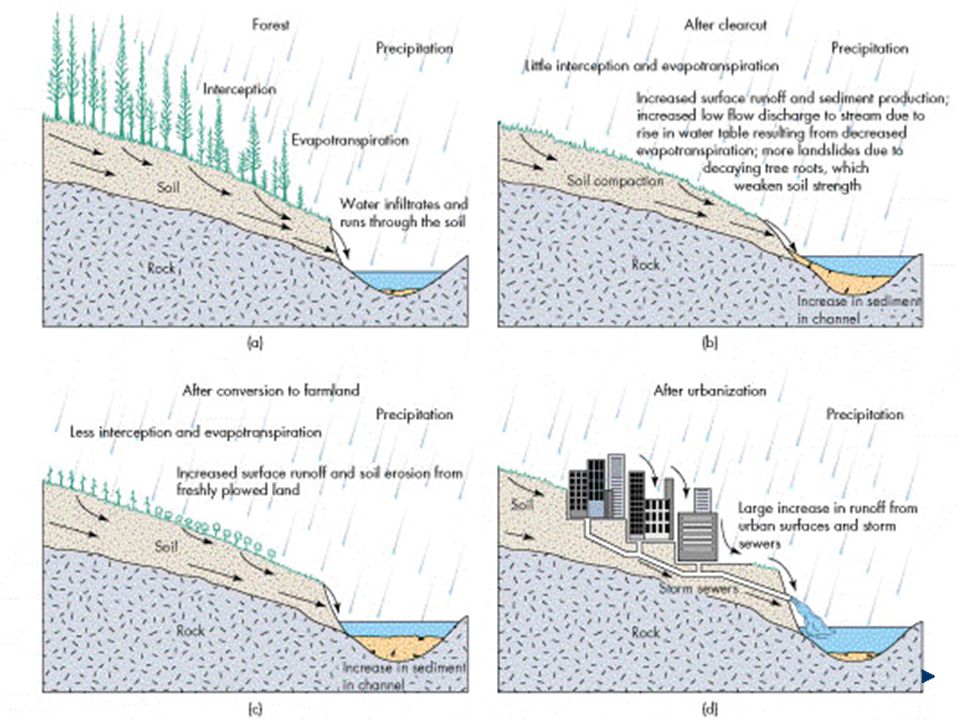
Human activities affect soils by influencing patterns, amounts, and intensity of: Surface-water runoff Erosion Sedimentation Conversion/manipulation of natural areas & surface water (see Figures 3.12, 3.13)
")
47
Land Use & Other Soil Problems
Urbanization Off-Road Vehicles Soil Pollution Desertification Others

48
Corrective Measures Erosion Controls Pollution abatement Others?
Terracing, contour stripping Vegetation barriers Water/sediment basins/reservoirs Characterization & planning Pollution abatement Treament, e.g., bioremediation Others?

49
Summary/Overview Definitions of soil Variables (explain)
Roles of soils in environmental geology Land use planning Waste disposal Evaluation of natural hazards Formed from rock interactions in the hydrologic cycle (explain) Variables (explain) Climate Topography Parent material Time Organic activity Soil processes form distinctive layers (horizons) Soil Properties: Color Texture (particle size) Structure (peds)
 Variables (explain) Climate. Topography. Parent material. Time. Organic activity. Soil processes form distinctive layers (horizons) Soil Properties: Color. Texture (particle size) Structure (peds)")
50
Learning Objectives Conditions that make some natural processes hazardous Benefits of hazardous natural processes Types of natural hazards Prediction of natural disasters Perception and adjustments to natural hazards Impact and recovery from natural disasters and catastrophes

51
Natural Processes as Hazards
Natural hazards = Natural processes Types/examples: Earthquakes Rivers & flooding Mass movement (e.g., landslides, mudslides, avalanches) Volcanic activity Coastal hazards Others: Cyclones, tornados, hurricanes Lightning Radon Etc.
 Volcanic activity. Coastal hazards. Others: Cyclones, tornados, hurricanes. Lightning. Radon. Etc. ")
52
Benefits of Natural Hazardous
Natural hazards that have benefits: Flooding Landslides Volcanism Earthquakes Explain

53
Risk = Probability x Consequence
Risk Assessment Risk = Probability x Consequence E.g., risk of death from smoking cigarettes Consequence = Death (could be other effects) Probability = Frequency of this consequence in a population Must be calculated for various scenarios/events, e.g., earthquake of various magnitudes, proximity to population centers, structures (nuclear plant, dam)
 Probability = Frequency of this consequence in a population. Must be calculated for various scenarios/events, e.g., earthquake of various magnitudes, proximity to population centers, structures (nuclear plant, dam) ")
54
Acceptable risk There is risk associated with everything
There is no such thing as zero risk, only different levels of risk e.g., Everyone is exposed to risks everyday (e.g., driving, radon) Levels of Acceptable Risk are, therefore, established Examples of Acceptable Risk Levels are used in toxicology & human health risk assessments e.g., Increased acceptable risk from exposure to cancer-causing chemicals is typically (risk of death from natural levels of radon = 10-3 ) What do these numbers mean?
 Levels of Acceptable Risk are, therefore, established. Examples of Acceptable Risk Levels are used in toxicology & human health risk assessments. e.g., Increased acceptable risk from exposure to cancer-causing chemicals is typically 10-6 (risk of death from natural levels of radon = 10-3 ) What do these numbers mean ")
55
Relationship Between Hazards and Climate Changes?
System interrelationships or feedback of annual weather and/or climate changes? E.g., El Nino, La Nina, others Global warming? Connections between weather/climate and: Storms Fires Floods Drought (hydrologic cycle) Food supply (fishing to agriculture) Energy (e.g., demand vs. hydroelectric supply) etc. (See Text Chart)
 Food supply (fishing to agriculture) Energy (e.g., demand vs. hydroelectric supply) etc. (See Text Chart) ")
56
Population, Land-Use and Natural Hazards
Effects of Population Increase Proximity issues (e.g., quakes, volcanoes, floods) Cause & effect issues(Mexico City example) Changing Land-Use Effects Disruption of natural system buffers Changed/exacerbated feedback Examples: Yangtze River flooding Hurricane in Central America Reasons?
 Cause & effect issues(Mexico City example) Changing Land-Use Effects. Disruption of natural system buffers. Changed/exacerbated feedback. Examples: Yangtze River flooding. Hurricane in Central America. Reasons ")
57
Learning Objectives: Rivers & Flooding
Appreciation for river processes Flood hazard Nature & extent Upstream vs. downstream flooding Effects of urbanization (in small drainage basins) Main preventive & adjustment measures Environmental effects of channelization
 Main preventive & adjustment measures. Environmental effects of channelization.")
58
Main Topics River Systems/Processes Features & Landforms Flooding:
Factors Prevention Case Studies

59
Sediments in Rivers Load: Quantity of sediment carried in a river
Bed load: moved along bottom Suspended load: carried in suspension Dissolved load: in solution

60
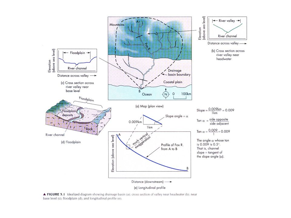
Slope & Profiles Slope or gradient
= vertical drop /horizontal distance (e.g., km/km) Gradient angle = tan-1 (gradient) e.g., for gradient of 0.01, tan-1 (0.01)=0.5o Longitudinal profile Graph of elevation vs. distance downstream
 Gradient angle = tan-1 (gradient) e.g., for gradient of 0.01, tan-1 (0.01)=0.5o. Longitudinal profile. Graph of elevation vs. distance downstream.")
62
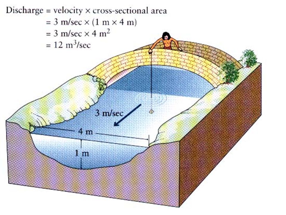
Key Parameters & Relationships Continuity Equation
Discharge (m3/sec) = Q = volume of water passing a point per unit time Velocity (m/sec) Cross-sectional area (width x depth): (m2) Q = v x W x D (At constant slope)
 = Q = volume of water passing a point per unit time. Velocity (m/sec) Cross-sectional area (width x depth): (m2) Q = v x W x D. (At constant slope)")
64
Key Parameters & Relationships Stream Power & Capacity
Stream Power (P): ability to transport and/or erode sediment P = Q x slope x r ; where r = 10-5 kg/m3; units of P = (kg/sec) P = velocity x width x depth x slope x density i.e., - narrower, shallower streams, have higher velocities; erode - wider, deeper streams, have lower velocities; deposit - Steeper gradients, higher velocities, erode & vice-versa Capacity = total load that can be carried/time (e.g., kg/sec) Competence = largest particle (diam.) a river may transport •
: ability to transport and/or erode sediment. P = Q x slope x r ; where r = 10-5 kg/m3; units of P = (kg/sec) P = velocity x width x depth x slope x density. i.e., - narrower, shallower streams, have higher velocities; erode. - wider, deeper streams, have lower velocities; deposit. - Steeper gradients, higher velocities, erode & vice-versa. Capacity = total load that can be carried/time (e.g., kg/sec) Competence = largest particle (diam.) a river may transport. •")
65
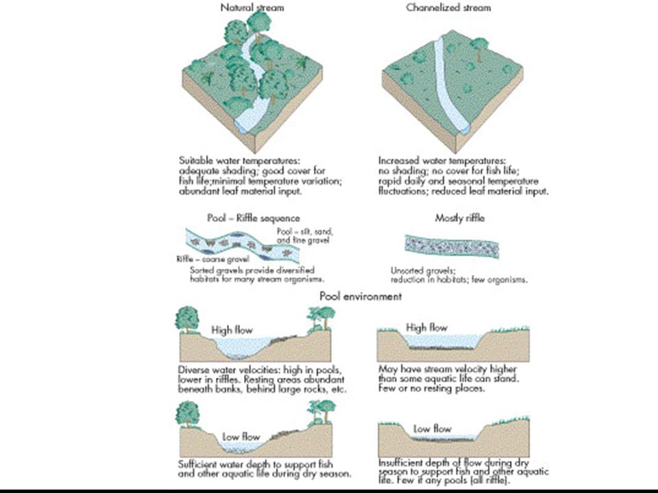
Balance (equilibrium) between deposition/erosion as function of D (Q, velocity, etc.)
Along the longitudinal profile (headwaters vs. downstream) Pools Riffles Bars
 Pools. Riffles. Bars.")
66
Balance (equilibrium) between deposition/erosion as function of D (Q, v, x-sect. dimensions, etc.)
In response to land-use changes (e.g., dams)
")
67
Balance (equilibrium) between deposition/erosion as function of D (Q, v, x-sect. dimensions, etc.)
Flooding (general) Floodplains & features
 Floodplains & features.")
68
Upstream floods Downstream floods Intense rainfall Of short duration
Over relatively small area E.g., flash floods Downstream floods Cover a wide area Produced by storms of long duration Saturated soil increased runoff Contribution from many tributaries E.g., regional storms, spring runoff

69
Factors That Affect Flooding
Rainfall (weather) events Local vs. regional Seasonal 50, 100-year floods Runoff (factors affecting infiltration) Gradient Vegetation Human effects Urbanization (e.g., paving, storm sewers) Others?
 events. Local vs. regional. Seasonal. 50, 100-year floods. Runoff (factors affecting infiltration) Gradient. Vegetation. Human effects. Urbanization (e.g., paving, storm sewers) Others")
70
Flood Damage Prevention/ Control
Physical barriers Levees/bank stabilization Dams Retention ponds Floodplain regulation Optimizing floodplains w/ minimal flood damage Balance of natural resource w/ natural hazard Zoning Diversion channels/reservoirs River management (plans to minimize bank erosion, etc. Flood hazard mapping Channelization

71
Channelization Engineered modification of stream channels Objectives
Straightening Deepening Widening Clearing Lining Objectives Flood control Drainage Erosion control Improved navigation

72
Pros & Cons of Chanelization
Pros (Benefits) Same as objectives where benefits outweigh environmental damage/degradation Cons (Adverse Effects) Environmental Degradation Wetland drainage Vegetation elimination/decrease Habitat effects Erosion, siltation River flow pattern effects Aesthetic effects
 Same as objectives where benefits outweigh environmental damage/degradation. Cons (Adverse Effects) Environmental Degradation. Wetland drainage. Vegetation elimination/decrease. Habitat effects. Erosion, siltation. River flow pattern effects. Aesthetic effects.")
74
Learning Objectives Gain a basic understanding of slope stability and mechanisms of slope failure Understand the role of driving and resisting forces affecting slope stability Understand factors that affect slope processes: Topography Climate Vegetation Water Time (Gravity) (rock type) Understand how human use of land affect landslides & slopes Familiarization with identification, prevention, warning, & correction of landslides Appreciation for processes related to land subsidence (Part B)
 (rock type) Understand how human use of land affect landslides & slopes. Familiarization with identification, prevention, warning, & correction of landslides. Appreciation for processes related to land subsidence (Part B)")
76
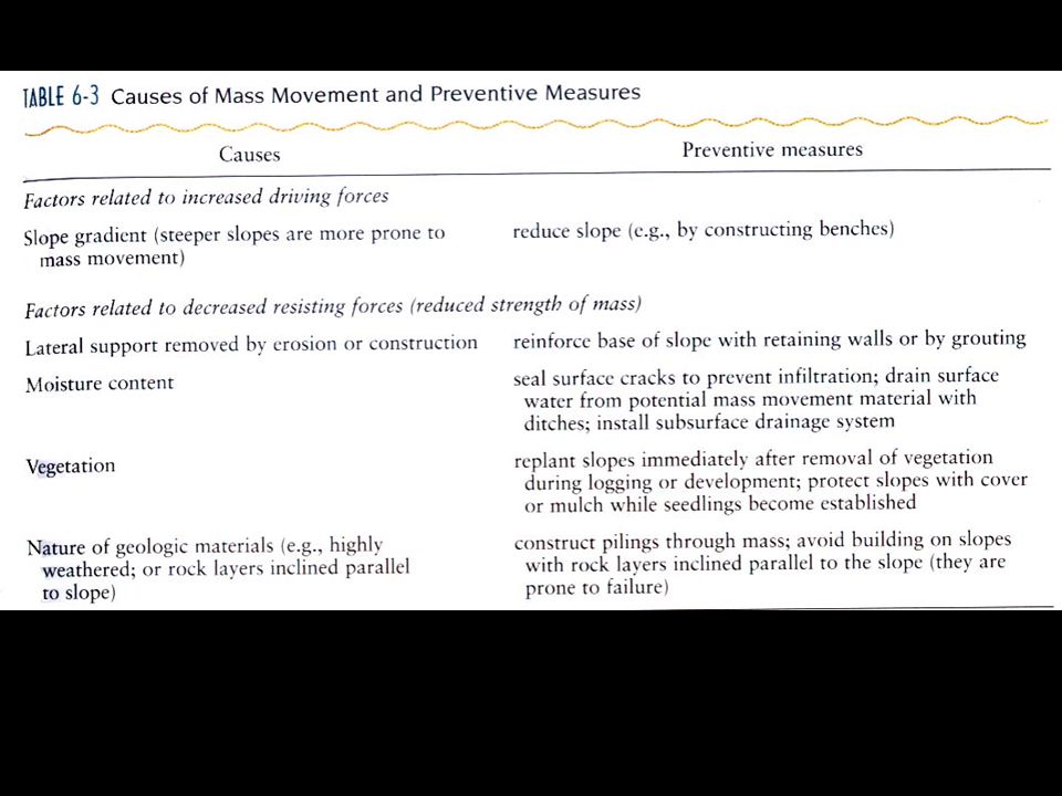
Slope Stability Relationship between driving & resisting forces
Driving forces (DF) Weight of rock, soil Weight of superimposed material Vegetation Fill Buildings Resisting forces (RF) Shear-strength of slope material acting along potential slip planes Cohesion Internal friction Ratio RF/DF = Factor of Safety (FS) >1.0 = stable <1.0 = unstable Subject to changed conditions (see example; fig. 6.4)
 Weight of rock, soil. Weight of superimposed material. Vegetation. Fill. Buildings. Resisting forces (RF) Shear-strength of slope material acting along potential slip planes. Cohesion. Internal friction. Ratio RF/DF = Factor of Safety (FS) >1.0 = stable. <1.0 = unstable. Subject to changed conditions (see example; fig. 6.4)")
77
Causes of Landslides Real Causes Immediate causes (triggers)
Driving Forces > Resisting Forces Immediate causes (triggers) Earthquake shocks Vibrations Sudden increase in water External Causes Slope loading Steepening Internal Causes: Causes that reduce shear strength
 Earthquake shocks. Vibrations. Sudden increase in water. External Causes. Slope loading. Steepening. Internal Causes: Causes that reduce shear strength.")
78
Functional Relationships
Relationship between downward force (gravity) & Resistance force (shear stress) Stress = force / unit area S = shear stress S = C + (p-u) tanq; p = total pressure u = fluid pressure (pore water pressure) tan q = coefficient of internal friction q = angle of internal friction (frict. resist.) S = C + (sn -u) tanq; sn = normal stress (i.e., normal to surface or plane of discontinuity C = cohesion of material
 & Resistance force (shear stress) Stress = force / unit area. S = shear stress. S = C + (p-u) tanq; p = total pressure. u = fluid pressure (pore water pressure) tan q = coefficient of internal friction. q = angle of internal friction (frict. resist.) S = C + (sn -u) tanq; sn = normal stress (i.e., normal to surface. or plane of discontinuity. C = cohesion of material.")
79
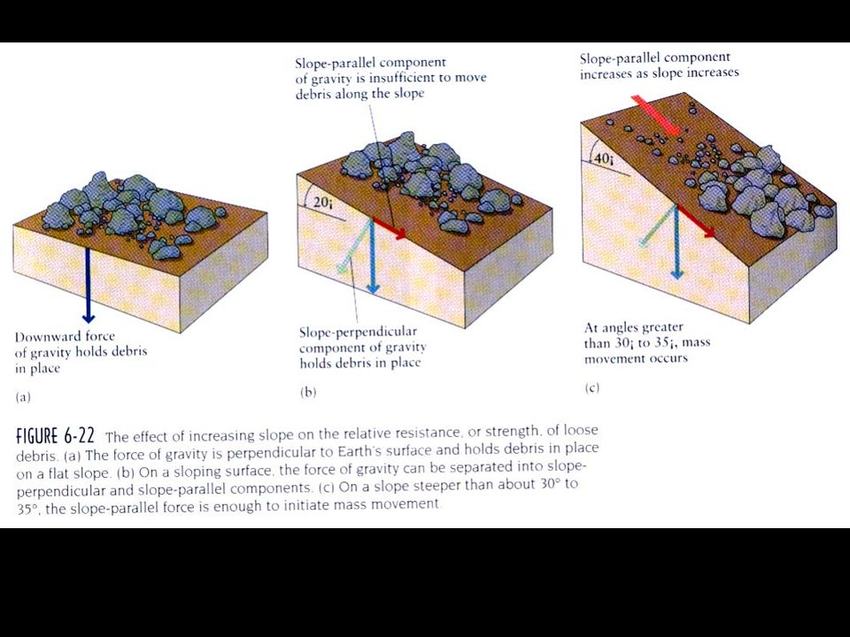
Factors/Controls Gravity Slope and topography Water Rock Type
Weight (force); downslope component of the weight of the slope materials above the slip plane Downward Normal to surface or plane of discontinuity (sn) Parallel to surface or plane of discontinuity Angle of repose (slope angle) Slope and topography Water Rock Type Structure Others? (Anthropogenic)
; downslope component of the weight of the slope materials above the slip plane. Downward. Normal to surface or plane of discontinuity (sn) Parallel to surface or plane of discontinuity. Angle of repose (slope angle) Slope and topography. Water. Rock Type. Structure. Others (Anthropogenic)")
81
Factors Resulting in Decreased Slope Stability
Increased pore pressure (affects sn); e.g., Storms, fluctuating groundwater Increased water content (reduces C, q) Steepening of slopes (affects sn) Loading of slopes (affects sn) Earthquake shaking (reduces C, q) Removal of material from the base of slopes (Directly reduces S) Rivers, waves, man Changes in vegetation Change in chemical composition of pore water
; e.g., Storms, fluctuating groundwater. Increased water content (reduces C, q) Steepening of slopes (affects sn) Loading of slopes (affects sn) Earthquake shaking (reduces C, q) Removal of material from the base of slopes (Directly reduces S) Rivers, waves, man. Changes in vegetation. Change in chemical composition of pore water.")
82
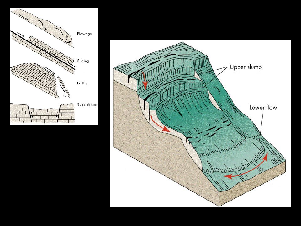
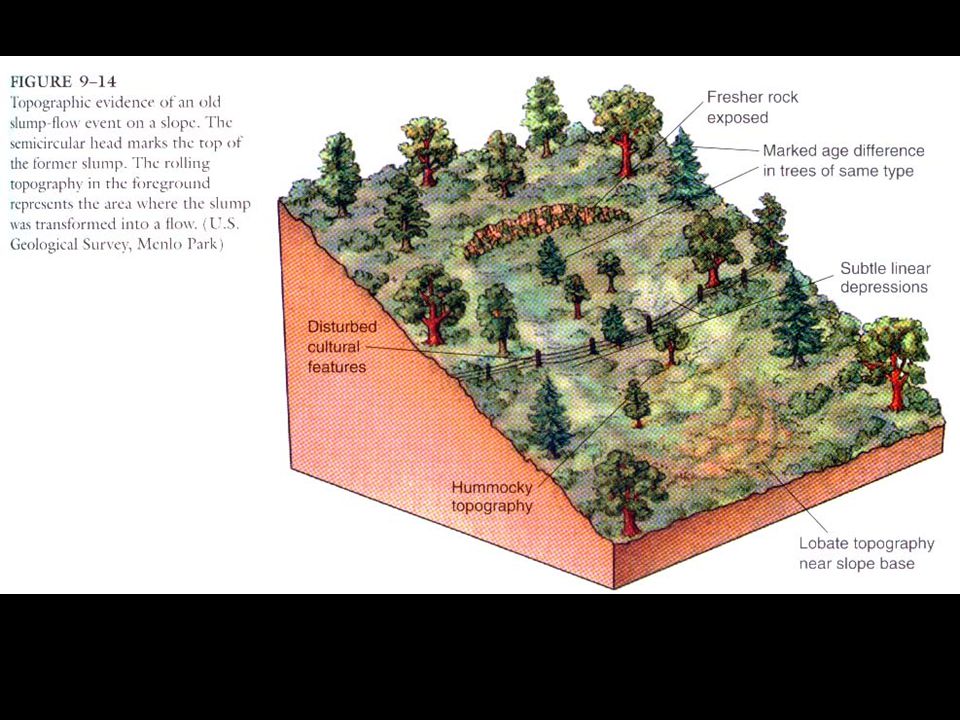
Roles of Rock/Soil Type
Patterns of movement Rotational slides (slumps) occur along curved surfaces Produces topographic benches (see fig.) Commonly occur in weak rock types (e.g., shale) Translational slides Planar Occur along inclined slip planes within a slope (6.2) Fractures in all rock types Bedding planes in rock slopes Clay partings Foliation planes (metamorphic rocks) Soil Slips Type of translation slide Slip plane above bedrock, below soil Colluvium
 occur along curved surfaces. Produces topographic benches (see fig.) Commonly occur in weak rock types (e.g., shale) Translational slides. Planar. Occur along inclined slip planes within a slope (6.2) Fractures in all rock types. Bedding planes in rock slopes. Clay partings. Foliation planes (metamorphic rocks) Soil Slips. Type of translation slide. Slip plane above bedrock, below soil. Colluvium.")
83
Role of Climate & Vegetation
Controls nature/extent of ppt., moisture content Vegetation effects (dependent on plant type) Enhances infiltration/retards erosion Enhanced cohesion Adds weight to slope Transpiration reduces soil moisture
 Enhances infiltration/retards erosion. Enhanced cohesion. Adds weight to slope. Transpiration reduces soil moisture.")
85
Minimizing Landslide Hazards
Identification of potential landslides Prevention of Landslides Drainage controls Grading Slope supports Warning systems Landslide correction

87
Causes of Landslides Real Causes Immediate causes (triggers)
Driving Forces > Resisting Forces Immediate causes (triggers) Earthquake shocks Vibrations Sudden increase in water External Causes Slope loading Steepening Internal Causes: Causes that reduce shear strength
 Earthquake shocks. Vibrations. Sudden increase in water. External Causes. Slope loading. Steepening. Internal Causes: Causes that reduce shear strength.")
88
Subsidence: Learning Objectives:
Understand the types of subsidence and the causes of each type Key controls of subsidence processes, and mitigation Human effects that promote or mitigate subsidence

89
Types of Subsidence Subsidence at or near the surface: (Volume losses)
Withdrawal of fluids Underground Mining Dissolution of limestone or salt deposits

90
Subsidence at or near the surface: (Volume losses)
Above compressible (fine-grained) sediments Associated with clayey soils Draining or decomposition of organic deposits
 sediments. Associated with clayey soils. Draining or decomposition of organic deposits.")
92
Learning objectives Understand the relationship of earthquakes to faulting Familiarization with earthquake wave (energy) terminology Understand the concept of earthquake magnitude (and its calculation) How seismic risk is estimated Familiarization with the major effects of earthquakes The prediction of earthquakes Mitigation of earthquake damage
 How seismic risk is estimated. Familiarization with the major effects of earthquakes. The prediction of earthquakes. Mitigation of earthquake damage.")
93
Earthquake Processes Faults and Fault Movement
Relationship to plate tectonics Geographic distribution Relationship to plate boundaries Shallow earthquakes Deep earthquakes

94
Types of Plate Boundaries & Seismicity
Transform-Margin Earthquakes Intraplate Earthquakes Basin and Range; Mid-Continent Divergent-Margin Earthquakes Convergent-Margin Earthquakes

95
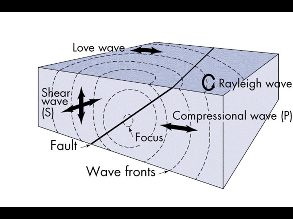
Seismic Waves and Ground Shaking
Focus: Point/area where rupture starts Epicenter: point on earth’s surface directly above the focus Types of seismic waves Body waves: waves travel within the earth P- waves: Primary compression waves S- waves: Shear waves Surface waves L-(Love) waves: horizontal ground movement Rayleigh waves: rolling motion
 waves: horizontal ground movement. Rayleigh waves: rolling motion.")
96
Seismic Waves Waves=Forms of energy release Motion/propagation types
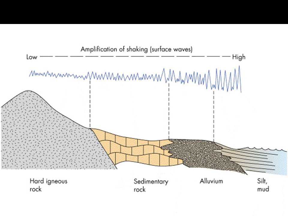
Frequency: Number of waves passing a reference point/sec Period: Number of seconds between successive peaks Amplitude: Measure of ground motion Attenuation/amplification

99
Comparing/Measuring Earthquakes
Magnitude Measure of energy released (log scale) measurement scale = Richter scale (0-10) Intensity: Relative scale: based on perceived damage Modified Mercalli Scale (1-12) Ground acceleration during earthquakes Rate of change of horizontal or vertical velocity of the ground Normalized/compared to earth’s gravity; 9.8 m/sec2= 1g e.g., M = quake g
 measurement scale = Richter scale (0-10) Intensity: Relative scale: based on perceived damage. Modified Mercalli Scale (1-12) Ground acceleration during earthquakes. Rate of change of horizontal or vertical velocity of the ground. Normalized/compared to earth’s gravity; 9.8 m/sec2= 1g. e.g., M = quake g.")
100
Elastic Rebound Model

101
Elastic Rebound

102
Dilatancy-Diffusion Model/Fault Valve Mechanism

103
Earthquakes Caused by Human Activity
Reservoir-induced seismicity Deep waste disposal Nuclear explosions

104
Effects of earthquakes
Ground shaking and rupture Liquifaction Landslides Fires Tsunamis Regional changes in land elevation

105
Earthquake Damage Buildings: Swaying, Pancaking
Broken pipelines (gas, water) & electrical lines Fires & explosions (from pipelines & storage tanks) Shearing & subsidence of sand fills Quicksand, sand boils, sand volcanoes Quickclays Landslides
 & electrical lines. Fires & explosions (from pipelines & storage tanks) Shearing & subsidence of sand fills. Quicksand, sand boils, sand volcanoes. Quickclays. Landslides.")
106
Origins of Tsunamis Sudden vertical displacement of seafloor (from dip-slip fault) Momentary drop in local sea level Water rushes into depression, but overcorrects, locally raising the sea level Sea level locally oscillates before stabilizing Oscillations are transmitted as long, low seismic sea waves

107
Response/Prediction Options

108
Response to Earthquake Hazards
Earthquake hazard-reduction programs Earthquakes and critical facilities Societal adjustments to earthquakes structural protection land-use planning increased insurance and relief measures earthquake warning systems perception of earthquake hazard

109
My Objectives How are they formed? How do they work?
Where do they occur, and why? Main types of volcanic activity, eruptive styles, and products Volcanic landforms Volcanic hazards, prediction, mitigation Relationships

110
Volcanism Correlations

111
Relationships Between Plate Tectonic Mechanisms,Volcanic Styles & Products
Basaltic magmas: Derived from melting of mantle Ocean-ridge & plume eruptions Magmas w/o crustal contamination More Si-rich magmas: Involve melting of crust, and/or flux-melting of mantle from de-watered subducted crust Subduction-related Mid-continent eruptions w/ crustal contamination

113
Classification by magma type
Two main end-member types: Basaltic (equivalent of gabbro) Rhyolitic (equivalent of granite) Other types Intermediate between basaltic and rhyolitic (andesitic) Exotic (alkaline)
 Rhyolitic (equivalent of granite) Other types. Intermediate between basaltic and rhyolitic (andesitic) Exotic (alkaline)")
114
Volcanic Products

115
Volcanic Hazards Lava flows Pyroclastic (hot debris) Hazards: Gases
Falls tephra ash pyroclastic (ash) flows explosive blasts Gases Debris & Mud Flows Others
 flows. explosive blasts. Gases. Debris & Mud Flows. Others.")
116
Volcanic Products

117
Caldera Eruptions When an erupting volcano empties a shallow-level magma chamber, the edifice of the volcano may collapse into the voided reservoir, thus forming a steep, bowl-shaped depression called a caldera (Spanish for kettle or cauldron).
.")
118
Volcanic Hazards Lava flows Pyroclastic (hot debris) Hazards: Gases
Falls tephra ash pyroclastic (ash) flows explosive blasts Gases Debris & Mud Flows Others
 flows. explosive blasts. Gases. Debris & Mud Flows. Others.")
119
Case Histories Nevado del Ruiz Mt. St. Helens Long Valley Caldera
Mt. Pinatubo Mt. Unzen, Japan

Similar presentations


>")
 Effects of earthquakes (damage) Earthquake risk and prediction Responses to earthquake hazards.>")


 terminology Understand the.>")
