Download presentation
Presentation is loading. Please wait.

2
Why Do We Have Weather?

3
An Introduction Take good notes! There will be a quiz at the end of this presentation.

4
WHY DO WE HAVE THE WEATHER ? Just think about it! Why is there wind? Why does it blow from one direction one day and another the next? Why is it rainy one day and dry the next? Why is it cold in the winter? How can we have hail in the summer? What causes snow and freezing rain?

5
Let’s take a look at the weather picture and why we have weather!

6
Weather Changers Air moisture Air temperature Air pressure Air direction and speed Clouds

7
If we were to pick one term to help explain why we have weather, what do you think would be a good word? You might pick heat or sun….but another good choice would be Convection

8
Convection is the transfer of heat, usually in gases or liquids.

9
After the atmosphere is warmed by radiation and conduction, the heat is transferred throughout the atmosphere by convection. Since warmed air has more space between the molecules, it’s less dense and rises Cooled air is more dense and tends to sink In general, air near the equator tends to rise and air near the poles tends to sink

10
Take a look at this!

11
Notice the band of clouds around the equator ? This is the ITCZ or inter tropical convergence zone

12
Why do you think there is this band of clouds near the equator?

13
Masses of small water droplets or tiny ice crystals that float in the air. Three main types are cirrus, cumulus, and stratus. Other clouds are a mixture of these three main types.

15
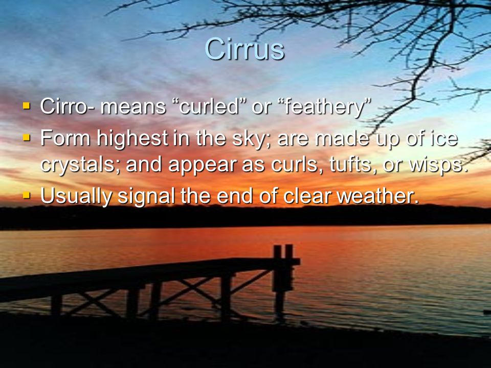
Cirrus Cirro- means “curled” or “feathery” Form highest in the sky; are made up of ice crystals; and appear as curls, tufts, or wisps. Usually signal the end of clear weather.

16
Cumulo- means “heaped” or “piled” Cottony clouds with flat, usually gray bases, and puffy, bright tops. Usually signal good weather, but if atmosphere is unstable, can build into towering clouds that produce showers and thunderstorms.

17
Stratus Strato- means “layer-like” or “sheet-like.” Low-lying, dull-colored clouds that form in layers or sheets. Usually bring drizzling rain or light-falling snow.

18
Nimbus A rain cloud

19
Did you figure it out? Warm, moist air in the topics rises Cold air can hold less moisture than warm air As the moist air rises, it condenses and forms clouds! More on this later

20
Consequences of Rotation: the Coriolis effect

21
Wind Anemometer instrument that measures wind speed. instrument that measures wind speed.

22
The Weather Highways The rotation of the earth creates the Coriolis effect. The Coriolis effect causes the air and water to be deflected to the right north of the equator. This creates global weather highways

23
The Westerlies Because of our latitude, most of our weather comes from the west Looking at the weather map, what type of weather might we expect? What type of weather might we expect in a few days?

24
Let’s break for a short review 1.Transfer of heat in liquids or gases_____ 2. _____ air is dense and tends to sink. 3. Band of clouds found around the equator______ 4. Cold air holds _____ moisture than warm air 5. The Coriolis effect causes the air and water to be deflected to the _____ of the equator

25
How did you do? 1. CONVECTION 2. COLD 3. ITCZ 4. LESS 5. RIGHT

26
Now What? Ok, so we know that the weather moves around on these highways and that warm air rises and cold air sinks. But why is it sunny one day, and rainy the next?

27
Let’s take another look at the weather map Notice that there are H ’s and L ’s on the map There are also blue lines with spikes and red lines with half circles Let’s take a closer look!

28
Air Masses Air masses form over source regions, which are large, relatively flat areas over the Earth’s surface with relatively uniform characteristics. Air masses typically have a surface high pressure system at their center.

29
High Pressure Areas When cooler air sinks and is warmed, the air can hold more moisture This usually means sunny skies Winds tend to move clockwise around a high

30
Low Pressure Areas When warm air rises and is cooled, the air can not hold as much moisture Often, these areas are associated with precipitation and stormy weather Winds tend to move counter clockwise around the low

31
So, if you see a big H on the weather map over the area you live, you can expect fair weather

32
When you see a big L in your area, there will probably be stormy weather

33
These highs and lows move or less along the jet stream and bring us our weather changes

34
Precipitation Water that falls from the clouds Air temperature determines the form of precipitation that falls 4 main types of Precipitation: Rain, Sleet, Snow and Hail

35
Types ofPrecipitation Types of Precipitation Rain Sleet Snow Hail

36
Fronts and Air Masses An air mass is a large body of air whose temperature and moisture are fairly similar at a given altitude Fronts are boundaries separating different air masses There are four different air masses that affect the United States

37
The Air Masses cP( continental polar) : cold, dry stable cT( continental tropical) : hot, dry, stable air aloft, unstable at the surface mP( maritime polar) : cool, moist, unstable mT( maritime tropical) : warm, moist, unstable
 : cold, dry stable cT( continental tropical) : hot, dry, stable air aloft, unstable at the surface mP( maritime polar) : cool, moist, unstable mT( maritime tropical) : warm, moist, unstable")
38
This map shows the air mass source regions and there paths

40
Ok, now we see the difference in the air masses Let’s look at the different fronts and their impact on weather Can you see the four different types of fronts on the map?

41
Fronts Extratropical cyclones are typically associated with fronts. A front represents the boundary between two different air masses. An air mass is a large body of air that has similar thermal and moisture characteristics in the horizontal directions.

42
Fronts (Cont.) Fronts are typically classified according to the direction of their movement. A warm front indicates that the warm air mass is pushing the colder air mass away.

43
Warm Fronts A warm front is warm air displacing cool air diagram Shallow leading edge warm air must “overrun” cold air These are usually slow moving

44
Warm Front N E Colder air mass Warmer air mass Warm front moves north as warmer air pushes out colder air.

45
Warm Front

46
Fronts (Cont.) A cold front indicates that the colder air mass is pushing out the warmer air mass.
 A cold front indicates that the colder air mass is pushing out the warmer air mass.")
47
Cold Fronts Cold air advances into region of warm air Intensity of precipitation greater, but short lived Clearing conditions after front passes Usually approaches from W or NW

48
Cold Front Warmer air mass Colder air mass Cold front moves south as colder air pushes out warmer air. N E

49
Cold Front

50
Stationary Fronts Surface positions of the front do not move Often a region of clouds

51
Stationary FrontStationary FrontStationary FrontStationary Front A stationary front is drawn when the boundary between the two air mass is not moving.

52
Stationary FrontStationary FrontStationary FrontStationary Front Warmer air mass Colder air mass N E

53
Stationary Front

54
Occluded Fronts Cold front overtakes warm front Often found close to the low pressure center

55
Occluded Front

56
Ready for a little quiz? You’ll need a sheet of paper Write your answers as we go Here we go!

57
1. Winds in a low pressure system move _____ around the low

58
2. What type of front can be found close to point D ?

59
3. Which of these fronts would you expect to have greater precipitation, but be short lived as the front passes?

60
4. Give the name of the air mass that would have the following characteristics: cool, moist, unstable

61
5. That important weather word that refers to the transfer of heat

62
6. In general, air near the equator tend to_____ ( rise or fall )
")
63
7. It causes air and water to be deflected to the right north of the equator

64
8. Which of the weather highways usually controls our weather

65
9. Warm air holds ( more or less ) moisture than cold air
 moisture than cold air")
66
10. If there is a big H on the weather map where you live, would you expect fair or stormy weather

67
How did you do? Let’s check the answers!

68
Answers 1. Counterclockwise 8. Westerlies 1. Counterclockwise 8. Westerlies 2. Cold 9. More 2. Cold 9. More 3. Cold 10. Fair 3. Cold 10. Fair 4. Maritime polar (mP) 4. Maritime polar (mP) 5. Convection 5. Convection 6. Rise 6. Rise 7. Coriolis 7. Coriolis
 4. Maritime polar (mP) 5. Convection 5. Convection 6. Rise 6. Rise 7. Coriolis 7. Coriolis.")
69
IPCC 2007a

71
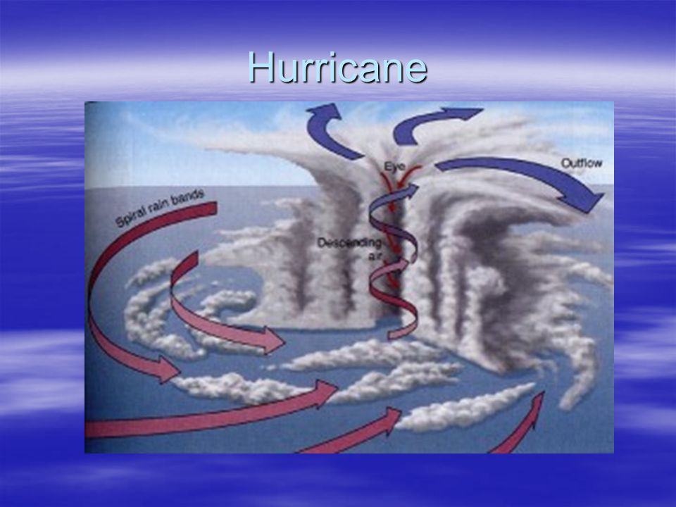
Hurricane

Similar presentations