Download presentation
Presentation is loading. Please wait.

1
Centre for Water Resources Software Vietnam Water Resources Institute 269 Chua Boc – Dong Da – Ha Noi, Viet Nam

2
Content Vietnam Water resources Institute Centre for Water Resource Software We would appreciate any suggestion and recommendation from you. Completed GIS ProjectsA focused productFunctions and techniquesOutputs and feedback

4
1. Management system of hydraulic works/constructs A client-server GIS application Hydraulic construct management Hydraulic works editing Thematic map building Connecting to the remote database Waterlogged and drought database management Land use information system? Irrigation information Harvest information system (cultivation, crop)
.")
5
2. The management system of Bird flu H5N1 Client – server GIS application Bird flu H5N1 management Make automatic report and Thematic map building Forecast the spreading trend of bird flu using expert system ( BF spread areas bases on spatially logical relationship)
.")
6
3. Rice Pests forecasting system A GIS web-based application Rice Pest Forecasting Service Make automatic report and thematic rice pest forecast maps frequently http://ttbvtv.vtic.vn/bvtv

8
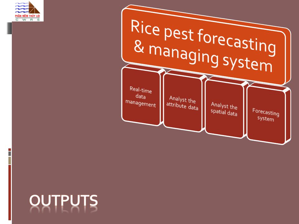
Functions 1 Real time data management ( Data has been collected for 2 years) Investigative and general data management: Pests, rice diseases, fertilize, infected areas, insect spray Make plan for areas using pesticide/insecticide. Data mining (analyst ) Forecast the developing/growing trend of the rice pests
 Forecast the developing/growing trend of the rice pests.")
9
Functions 2 Real time data management Data mining (analyst) Making report: status of seeding areas, pests, chemicals spray area; Thematically mapping infected areas; and rice development Forecast the developing trend of rice pests
 Making report: status of seeding areas, pests, chemicals spray area; Thematically mapping infected areas; and rice development Forecast the developing trend of rice pests")
10
Functions 3 Real time data management Data mining Forecast the developing trend of rice pests Forecasting report in 7-10 days Foresee in medium and long time period: yearly

11
The procedure of “data stream” inside the PPD before applying the project Non-synchronized data Low interactivity Limited information No GIS- Web interface sub department of Plan protection Plan protection department Sub department Email email Local council Email

12
Computer Server Highly interactive Web GIS interface Managing and forecasting services Synchronous data Customizing System Decision marking services The sub-PPD PPD Local council of PPD Other Data Mining The procedure after applying the project The procedure data stream” inside the PPD after applying the project

13
Technologies Open source: Integrated Development Environment : Eclipse WebGIS application : Geoserver GIS Client: OpenLayer Database: PostgreSQL and PostGIS Short time forecast (Expert system) deductive and cognitive method, applied for 2 main type of pests: Brown backed rice plant hopper and rice leaf folder. Medium and long time forecast: multi-variable linear regression algorithm Optimize: User-friendly Graphic User Interface Rice pest forecasting system Open source Short time forecast Optimize Long time Forecast

15
Real-time and online data management Real-time updating Pest data: Rice genre Pests Useful insects Pesticides Infected area Fertilize Supporting Decision Making, with the aim of using effectively pesticide

16
Twisted leaf Rice grassy stunt virus Brown backed rice plant hopper Rice leaf folder Attribute data analyst Automatic and real-time making report:

17
Spatial data analyst Real time making thematic maps of pest-infected area; rice growing period

18
Pests forecasting report in short and long time In-7-10 day forecasting

19
Pests forecasting report in short and long time Long-time forecasting

20
Feedbacks The system has been implemented for 4 different districts Mr. Le Viet Cuong: SPPD Hai Phong said: The system is user friendly, It is not difficult for DDP staffs to use functions in web. The web gis application is very helpful for the decision- maker to know the overview of plan, good insect or pest in the field. The report is flexibility based on the administrative area. It would be great for local council leaders who have quickly visual real-time information to make decisions. The video of this interview

21
Conclusion It is difficult to apply the project to many districts at the same time because it is complex problem. Our purpose will design one by one; and improve slowly after testing carefully. The 2 nd phase is designed to add more types of pest (Scirpophaga incertulas) and disease (Rice blast disease and leaf whitening) for PPD in Quang Ninh province. The remote sensing images will be used in a larger area.
 and disease (Rice blast disease and leaf whitening) for PPD in Quang Ninh province. The remote sensing images will be used in a larger area..")
22
Conclusion If other districts would like to use this system, it could save more time and money to build it up, only transferring fund would be spent.

23
Thank you &

Similar presentations