Download presentation
Presentation is loading. Please wait.

1
Presentation on TRANSPORTATION IN INDIA - CHALLENGES IN FUTURE By Prof. S. L. Dhingra Transportation Systems Engineering Civil Engineering Department Indian Institute of Technology, Bombay Organised by Research Scholars’ Forum Indian Institute of Technology Bombay 23rd Oct. 2002, Institute Auditorium

2
Overview National Highway Development Projects (NHDP) Pradhan Mantri Gram Sadak Yojana (PMGSY) Urban Transport Projects
 Pradhan Mantri Gram Sadak Yojana (PMGSY) Urban Transport Projects")
3
National Highways Development Project (NHDP)
")
4
Golden Quadrilateral - Comprising NHs Connecting Delhi, Mumbai, Chennai, and Kolkata. Length - 5,952 Kms Year of Completion - 2003 North-South & East-West Corridor - Comprising NHs Connecting Srinagar to Kanyakumari and Silchar to Porbandar. Length - 7,300 Kms Year of Completion - 2007 Total Estimated Cost = Rs.54,000 Crores (at 1999 Prices) Golden Quadrilateral - Comprising NHs Connecting Delhi, Mumbai, Chennai, and Kolkata. Length - 5,952 Kms Year of Completion - 2003 North-South & East-West Corridor - Comprising NHs Connecting Srinagar to Kanyakumari and Silchar to Porbandar. Length - 7,300 Kms Year of Completion - 2007 Total Estimated Cost = Rs.54,000 Crores (at 1999 Prices)
 Golden Quadrilateral - Comprising NHs Connecting Delhi, Mumbai, Chennai, and Kolkata. Length - 5,952 Kms Year of Completion North-South & East-West Corridor - Comprising NHs Connecting Srinagar to Kanyakumari and Silchar to Porbandar. Length - 7,300 Kms Year of Completion Total Estimated Cost = Rs.54,000 Crores (at 1999 Prices).")
5
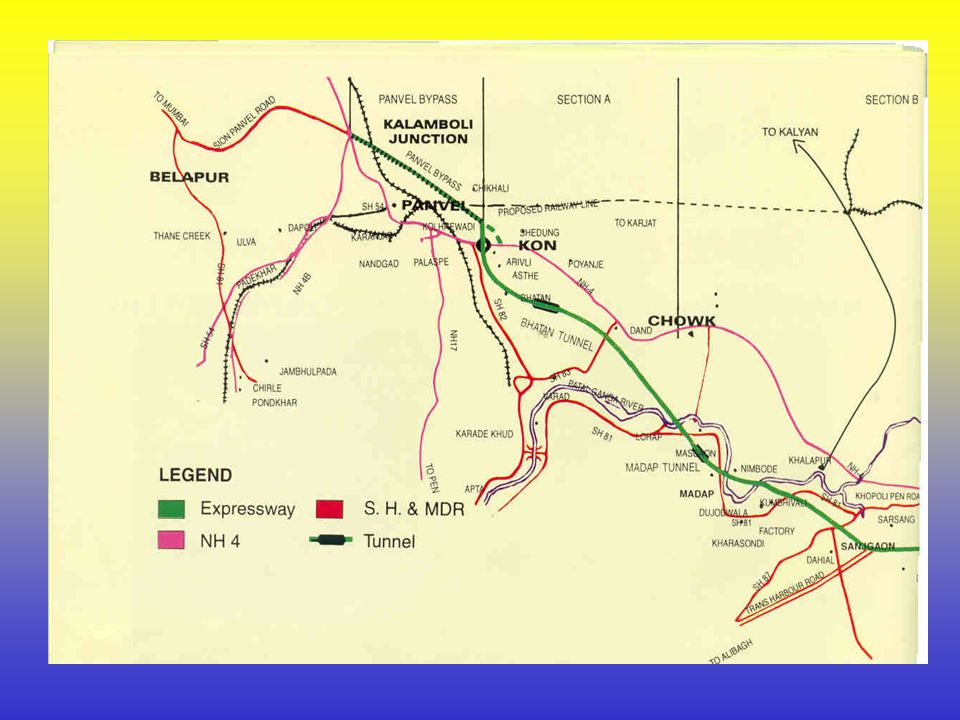
Mumbai--Pune Expressway

6
Mumbai--Pune Expressway Map

9
Environment Protection All conditions for environment are followed. One thousand trees trans planted. Extensive tree plantation, and median verge plantation plant. Separate dumping area is acquired for surplus material. Separate land is acquired for labour camp. Provision of recycling material and used for work. Provision for additional lead for transport of surplus material.

10
Special item to use surplus rock – gabbian, rock embankment. Murum from adjoining land and dumping black cotton soil from road – creation of new fertile agriculture land. Rain water drainage. Terracing to quarry area. Continued…

11
Social Problem Tendency of villagers to cross expressway, use of cycles & two wheelers in spite the provision of cart track & pedestrians crossing Tendency to overtake wrong side over speeding Observing no lane discipline

12
Advantages of the Expressway Time savings - Mumbai-Pune distance will be covered in 2 hours as against 4 to 6 hours in the present situation Estimated fuel and other savings to the extent of Rs.500 crores per year Reduction in environmental pollution due to vehicles running at rated capacity and less fuel consumption Reduction in Accidents

13
Savings in travel time Saving in fuel Fast crossing of Khandala Ghat Economic development through speedy traffic Reduction in pollution Continued…

15
Pradhan Mantri Gram Sadak Yojana Aiming for Rural Transformation

16
lOnly 48 % of villages are connected by all-weather roads. lNearly 50 % of villages lack proper connectivity. lProper rural road connectivity is a must for development. Why ? lBenefits – economic, social, political etc. lRural people can have easy access to lTrade lEducation lHealth lEmployment Current Scenario & need for providing road connectivity: the PMGSY Approach

17
The Highlights of PMGSY (Pradhan Mantri Gram Sadak Yojana) Investment of Rs. 60,000 Crore Road Connectivity (All-weather roads) Goals: - villages with population of more than 1000 (by 2003). - villages with population more than 500 (by 2007). Nearly 1,00,000 villages to be covered. Around 30 Crore (300 Million) people would be benefited. 10 Crore (100 Million) people expected to cross poverty line Hence, there is a need to plan for optimal rural road networks to achieve the objectives of integrated rural development.
 Goals: - villages with population of more than 1000 (by 2003). - villages with population more than 500 (by 2007). Nearly 1,00,000 villages to be covered. Around 30 Crore (300 Million) people would be benefited. 10 Crore (100 Million) people expected to cross poverty line Hence, there is a need to plan for optimal rural road networks to achieve the objectives of integrated rural development..")
18
Urban Transport Projects

19
Flyovers Bandra-Worli sea link Western Freeway link/ Hajiali-Wilson college viaduct Metro System (TCS Study) Elevated Railway System (by E. Sreedharan) MUTP II (MRVC Study) Mass Transit System (by MMRDA) Thane MRTS Sky Bus
 MUTP II (MRVC Study) Mass Transit System (by MMRDA) Thane MRTS Sky Bus.")
21
Mumbai : high traffic density, high traffic congestion. Whether we need flyovers? Geographical Layout : only N-S flow and very heavy traffic Consequent delays - city entry & exit Necessity of improving speeds on N-S Corridors Need to quickly reach starting points of proposed Expressways to Pune, Nashik & Ahmedabad from city centre

22
Flyovers on the 3 Main Routes 1.Western Express Highway (WEH) 2.Eastern Express Highway (EEH) 3.Sion-Panvel Express Way City Central Corridor developed by appropriate flyovers Elevated Road from J.J. Hospital to Crawford Market City Western Corridor-Flyovers on SB Marg Estimated cost is Rs. 1550 crores Of these 50 flyovers, 29 have been completed. Project Features

25
Air Pollution in Mumbai Sectorwise distribution of Pollution: Transport64% Power 4% Domestic15% Industrial17% Ambient Air Quality at Mahim Junction: 8090 – 107Nox 2001144 – 3170SPM 8043 – 120SO2 Limits (microgm/Nm3) Observed (microgm/Nm3) Item
 Observed (microgm/Nm3) Item")
28
Link connects Western Expressway at Mahim junction to Khan Abdul Gaffar Khan Road Bridge length: 4 km (0.5 main + 3.5 approach bridge) Solid approach road at Bandra: 1.8 km (including toll plaza) Carriageway - 8 lanes Cable stayed bridge of 500m length on single pylon Salient Features: Cont…
 Solid approach road at Bandra: 1.8 km (including toll plaza) Carriageway - 8 lanes Cable stayed bridge of 500m length on single pylon Salient Features: Cont…")
29
Viewers gallery at the top of central pylon at 150m height with access via capsule lift from pile cap Advanced Traffic control and surveillance system Estimated basic cost: Rs 650 crores Link proposed to be extended to Nariman Point A minimum clearance of 20 meters will be provided for main spans for marine traffic

30
Fuel savings worth Rs. 100 crores per annum Savings in travel time upto 20 - 30 minutes Reduction in air, noise & sound pollution Reduction of Nox by 43% & CO by more than 75% No adverse effect on tides, fisheries and livelihood of fishermen Ease in driving with reduced mental tension and overall improvement in the quality of life. Reduced accidents. Techno Economic Feasibility

31
Existing Situation: Distance from Lovegrove Jn to Mahim Junction = 7.7 km Traffic Signals = 23 Nos Travel time: – Morning peak hour = 35 min – Evening peak hour = 38 min Average Journey Speed = 13 kmph Savings due to Sea Link Direct Cost savings = Rs 14.11 per car (fuel, tyre,wear & tear, lubricants,etc) Travel time savings = 29 min per car Time value @ Rs 100/ hr = Rs 48.43 / car Hence, total savings = Rs 62.59 / car
 Travel time savings = 29 min per car Time Rs 100/ hr = Rs / car Hence, total savings = Rs / car")
35
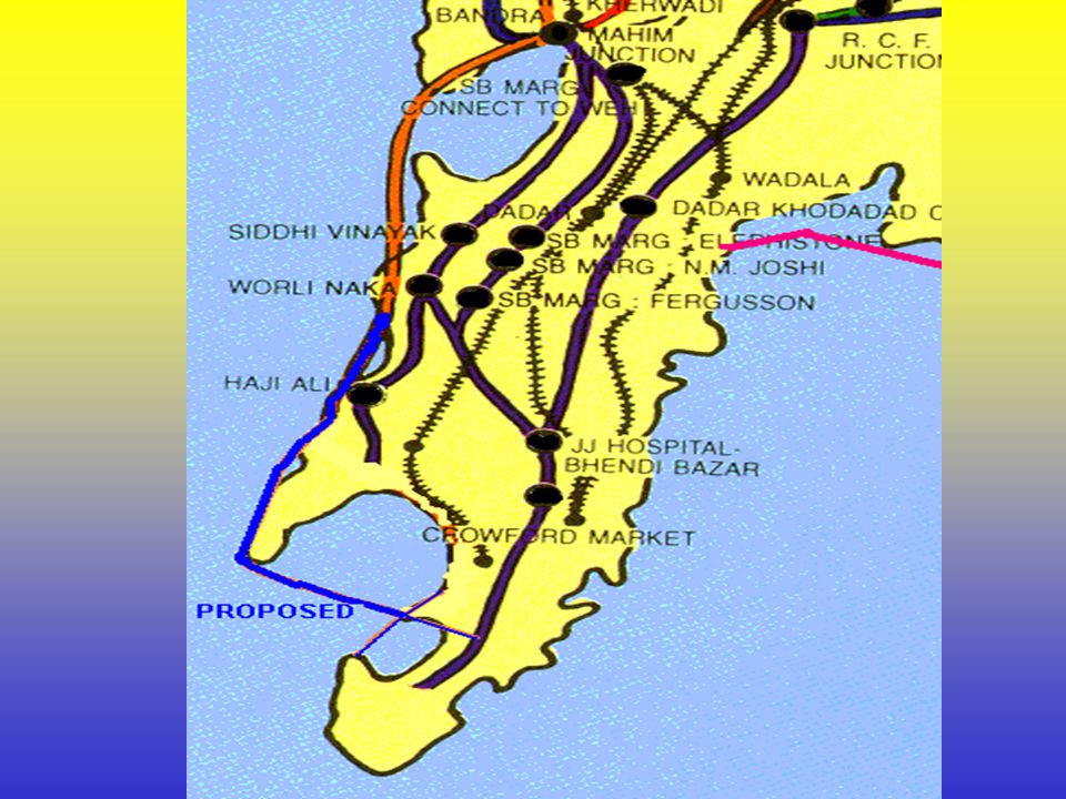
GPO sewri CST MPT Bandra Worli Wadala WESTERN FREE WAY SEA LINK BANDRAWORLI Hutatma Chowk Gateway of India Senapati Bapat Marg Savarkar Marg Ambedkar Marg Western rail Central rail Harbour rail Rafi Ahmed Kidwai Margs The Fourth Corridor

36
Alignment: Salient Features Total length 14.77 Km Starting from interchange at `Worli’ Alignment about 200 m in the sea from shore line Easy Traffic Dispersal - Interchanges with connecting links at - Haji Ali Circle, - Bhulabhai Desai Marg, - NCPA Nariman Point

37
Attributes Bridge spans to be provided withadequate vertical and Horizontal clearance Bridge spans to be provided with adequate vertical and Horizontal clearance Eco-friendly Sea link - no effect on tidal conditions Cable stayed bridges and viaducts - Improve aesthetics of the coastal area - Improve aesthetics of the coastal area - No Visual Intrusion from sea shore - No Visual Intrusion from sea shore Modern Traffic Surveillance System Minimum land reclamation, only near approaches

38
Benefits Vehicular pollution will be reduced Overall Improvement in environment Reduction in Pollution Reduction in Accidents Improvement in the existing transport system and living conditions Traffic will be dispersed

40
To reduce the surface traffic. To cater to the increase in traffic due to the emergence of Worli as business and industrial center. To decrease the level of pollution. To reduce the heavy load on local railways and buses. Why do we need metro system?

41
Salient Features: Location (7th corridor) Colaba to Kurla Length 22.4 Kms Average number of commuters per 24,20,000 day on a weekdays Travel time 39 min. Number of intermediate stations 24 Peak hour demand 50,689 Drainage will be taken care by sumps and automatic pumps.

43
Value and life of assets under major heads or groups NOTE : ‘N.A.’ denotes Not Applicable. Sr. No. Major Head or GroupCost Crores Life in Years 1. 2. 3. 4. 5. 6. 7. 8. 9. 10. 11. 12. 13. 14. 15. 16. 17. DPR Land Running Tunnels Other Underground Cavities Miscellaneous works in Tunnels Carshed Works Cut and Cover construction Administrative Office Building Ballastless Tracks Residential quarters Temporary track connection Power supply Electrical equipments S & T equipments Rolling stock General charges Contingencies 50.00 500.00 1177.05 633.77 344.09 114.42 242.60 20.00 46.51 27.00 25.00 89.60 1045.95 366.87 1950.00 554.40 216.22 N.A. Infinite 100 50 15 50 40 20 15 30 N.A. Total 7423.48

44
S. No. Main Head Amount (Rs. Crores) 1. 2. 3. 4. 5. 6. 7. 8. Preliminary expenses Land and right of way Structural engineering works Power supply and electrical equipments Signaling and telecom equipments (including automatic fare collection and checking system) Rolling stock Total Add general charges, (supervision and direction) @ 8.33% Total Add contingencies Total 50.00 500.00 2650.44 1135.55 366.87 1950.00 6652.86 554.40 7207.26 216.22 7423.48 Abstract estimate for 7th corridor
 Rolling stock Total Add general charges, (supervision and 8.33% Total Add contingencies Total Abstract estimate for 7th corridor.")
45
MRVC

46
Components Increase in corridors Longer (12 rake) EMUs Station area improvement schemes Removal of level crossings The resettlement and relocation of the project affected persons and structures all along Central and Western Railway corridors and the Harbour Line Total cost of the project is 5618.36 crores.
 EMUs Station area improvement schemes Removal of level crossings The resettlement and relocation of the project affected persons and structures all along Central and Western Railway corridors and the Harbour Line Total cost of the project is crores.")
47
To Kasara To Karjat/ Khopoli Kalyan Diva Jn. THANE Kurla Belapur Panvel To Karjat To Roha Virar Andheri Santacru z DADAR BANDRA Mumba i Central Churchgate Mumbai CST To Dahanu Rd. Turbhe CENTRAL RAILWAY LOCAL LINE THROUGH LINE HARBOUR LINE OTHER LINES WESTERN RAILWAY LOCAL LINE THROUGH LINE 5 TH LINE Vasai Rd. Wadala Rd. Borivali VashiNerul Uran Mumbai Suburban System Map Mumbai Suburban System Map

48
Benefits Increase in capacity by about 35% Higher frequency of train services during peak hours Reduction in journey time Improvement in the flow of passengers and vehicles in and selected stations Rail Project Cont…

49
Non-Rail Projects Reduction in traffic congestion, increase in vehicular speeds and reduction in delays Increased carrying capacity for bus users Safe and smooth flow of vehicular and pedestrian traffic Minimizing delays and accidents Improved environment through reduction in air pollution

50
Comparison between different modes of transport In terms of land usage railway is 24 times more efficient than road. Railway transport are 6 times more energy efficient than road transport. Bus travel is 5 times more costlier than railways. Road traffic is a major source of air pollution and noise pollution. Bus takes about 50% more time during peak hours as compared to rail.

51
S.No ProjectCategoryCost 15th line between Santacruz and Borivali on W R.Augmentation161.98 2Extra pair of lines between Kurla-Thane.Augmentation368.69 3Borivali-Bhayandar additional pair of line.Augmentation180.29 4Bhayandar-Virar additional pair of line.Augmentation406.40 5 Optimization of WR including 12 car on through line Optimization564.70 6 Optimization of CR including 12 car on through line Optimization613.63 7Optimization of Harbour line.Optimization292.69 8DC AC Conversion 601.00 9EMU Remanufacture 450.00 105th line Kurla-Dadar-CSTM.Augmentation229.20 11W R 6th line Borivali-Santacruz.Augmentation209.83 12Western Railway 12-car rake on local line.Optimization254.00 13Central Railway 12-car rake on local line.Optimization250.00 14East-West Bandra-Kurla link.Augmentation974.95 5618.3Total List of projects and their costs ( in crores of rupees)
")
52
MMRDA

53
MTS Alignment “C” C1 – CST to Mahalaxmi C2 – Mahalaxmi to Bandra C3 – Bandra to Andheri station C4 – Andheri to Charkop village C5 – Andheri station to Ghatkopar C6 – Mulund to Sahar Airport Alignment “C” is split into following 6 sections

55
Salient Features Maximum link flow is 51,000 per direction per hour. Network length is 57 km. Elevated section – 45 km Underground section – 12 km Total cost is Rs 118,885 million.

56
Andheri-Ghatkopar Alignment Length - 9 km Elevated section - 8.1 km Underground section – 0.9 km Investment cost - Rs. 820 crores Operating cost - Rs. 31 crores Peak hour ridership passengers – 40,000 Investment cost Rs. Per pass km – 40,091 Output pass-km per million Rupees – 24.94 Economic internal rate of return – 11.14%

58
Thane is one of the fastest growing cities. The city, spread over an area of 128 sq.km. has a population of 15.5 lakhs. High travel demand. Population doubling every decade. City expected to hit 30 lakhs by 2031. Development has increased the traffic tremendously. Need:

59
An MRTS that is…. ConvenientConvenient ComfortableComfortable FastFast Environment friendly during construction and operationEnvironment friendly during construction and operation

60
Existing Traffic Scenario Traffic Volumes at entry/ exit to Thane City –LBS Marg - 31758 PCUs –Eastern Expressway - 53481 PCUs Modal Split in Thane IPT Car Bus 2-W Cycle Bus & IPT together cater to about 65% trips (30.46 %) (33.28 %) (12.75 %) (8.15 %)(15.36 %)
 (33.28 %) (12.75 %) (8.15 %)(15.36 %)")
61
Rapid industrial development and population growth in Thane has resulted in large scale traffic movements. Population Growth: 14.5 lakhs in 2001. Demand for bus transportation is on the rise, but has Limitations due to. heavy congestion limited accessibility This has resulted in increase in personalized & IPT modes, thereby aggravating congestion & pollution levels. Government of Maharashtra has therefore envisaged the need for efficient, economical, equitable and environmental friendly Mass Rapid Transit System (MRTS) for the city.
 for the city..")
62
30m wide circular MRTS corridor proposed through major work and industrial area Total Route Length - 21 km Elevated - 12.25 km Surface Level - 8.75 km Total stations - Eleven (11) On ground - 8 Elevated Stations - 3 Estimated Project Cost: Rs 1000 crores Modern Traffic Management & Surveillance Systems Environmentally better system
 On ground - 8 Elevated Stations - 3 Estimated Project Cost: Rs 1000 crores Modern Traffic Management & Surveillance Systems Environmentally better system")
64
Cross-sectional view of Sky Bus

65
Salient Features of Sky Bus Maximum traffic carrying capacity: 15000 pphpd can be upgraded to 30000 pphpd. Dimension of Sky Bus (L*W*H): 8*2.8*2.4 Capacity of Sky Bus: 250 passenger Maximum permissible speed: 100 Kmph Acceleration: 1.3 m/sec 2 Minimum clearance above road level: 6 meters
: 8*2.8*2.4 Capacity of Sky Bus: 250 passenger Maximum permissible speed: 100 Kmph Acceleration: 1.3 m/sec 2 Minimum clearance above road level: 6 meters.")
66
Proposed route of Sky Bus

67
Meeting the demand Reducing the demand East west corridors Worli area Rail connection Colaba area Rail connection Churchgate-CST connection Integration of these systems to meet the total travel demand To Summarize…

Similar presentations