Download presentation
Presentation is loading. Please wait.

1
Satellite Orbits Satellite Meteorology/Climatology Professor Menglin Jin

2
Satellite Orbits n At what location is the satellite looking? n When is the satellite looking at a given location? n How often is the satellite looking at a given location? n At what angle is the satellite viewing a given location?

3
Atmospheric Remote Sensing Sensors, Satellite Platforms, and Orbits n Satellite orbits and platforms Low Earth orbitLow Earth orbit –Sunsynchronous and repeat coverage –Precessing Geosynchronous orbitGeosynchronous orbit n Sensor scanning modes Whiskbroom and pushbroom scannersWhiskbroom and pushbroom scanners Active and passive microwave radiometersActive and passive microwave radiometers

4
Orbital parameters can be tuned to produce particular, useful orbits Geostationary Geosynchronous Sunsynchronous Altimetric Special Orbits

5
Types of orbits n Sunsynchronous orbits: An orbit in which the satellite passes every location at the same time each day Noon satellites: pass over near noon and midnightNoon satellites: pass over near noon and midnight Morning satellites: pass over near dawn and duskMorning satellites: pass over near dawn and dusk Often referred to as “polar orbiters” because of the high latitudes they crossOften referred to as “polar orbiters” because of the high latitudes they cross Usually orbit within several hundred to a few thousand km from EarthUsually orbit within several hundred to a few thousand km from Earth

6
Types of orbits n Geostationary (geosynchronous) orbits: An orbit which places the satellite above the same location at all times Must be orbiting approximately 36,000 km above the EarthMust be orbiting approximately 36,000 km above the Earth Satellite can only “see” one hemisphereSatellite can only “see” one hemisphere
 orbits: An orbit which places the satellite above the same location at all times Must be orbiting approximately 36,000 km above the EarthMust be orbiting approximately 36,000 km above the Earth Satellite can only see one hemisphereSatellite can only see one hemisphere")
7
Ascending and descending orbits should cross at 90º – Designed so that orthogonal components of surface slope will have equal accuracy Orbital inclination depends on location of altimetric needs Altimetric Orbits

8
Geosynchronous Meteorological Satellites WMO Member States

9
Low Earth Orbit Concepts Equator South Pole Ground track Ascending node Inclination angle Descending node Orbit Perigee Apogee Orbit

10
Sun-Synchronous Polar Orbit Satellit e Orbit Earth Revolution Satellite orbit precesses (retrograde) –360° in one year Maintains equatorial illumination angle constant throughout the year –~10:30 AM in this example Equatorial illumination angle
 –360° in one year Maintains equatorial illumination angle constant throughout the year –~10:30 AM in this example Equatorial illumination angle")
11
Sun-Synchronous Orbit of Terra

12
Spacing Between Adjacent Landsat 5 or 7 Orbit Tracks at the Equator

13
Timing of Adjacent Landsat 5 or 7 Coverage Tracks Adjacent swaths are imaged 7 days apart

14
Polar-Orbiting Satellite in Low Earth Orbit (LEO) Example from Aqua
 Example from Aqua")
15
q A precessing low- inclination (35 ° ), low-altitude (350 km) orbit to achieve high spatial resolution and capture the diurnal variation of tropical rainfall –Raised to 402 km in August 2001 Tropical Rainfall Measuring Mission Orbit (Precessing)
, low-altitude (350 km) orbit to achieve high spatial resolution and capture the diurnal variation of tropical rainfall –Raised to 402 km in August 2001 Tropical Rainfall Measuring Mission Orbit (Precessing)")
16
TRMM Coverage 1 day coverage2 day coverage

17
The orbital period of a satellite around a planet is given by where 0 = orbital period (sec) R p =planet radius (6380 km for Earth) H=orbit altitude above planet’s surface (km) g s =acceleration due to gravity (0.00981 km s -2 for Earth) Definition of Orbital Period of a Satellite
 R p =planet radius (6380 km for Earth) H=orbit altitude above planet’s surface (km) g s =acceleration due to gravity ( km s -2 for Earth) Definition of Orbital Period of a Satellite")
18
Orbital Characteristics of Selected Missions Low Earth Orbit & Precessing Missions

19
Ellipse n An ellipse is defined as follows: For two given points, the foci, an ellipse is the locus of points such that the sum of the distance to each focus is constant. focilocussumconstantfocilocussumconstant n BTW, Locus-A word for a set of points that forms a geometric figure or graph setpointsgeometric figuregraphsetpointsgeometric figuregraph

20
Kepler’s laws 1. Satellites follow an elliptical orbit with the Earth as one focus Perigee Apogee Foci

21
Period of orbit n Valid only for circular orbits (but a good approximation for most satellites) n Radius is measured from the center of the Earth (satellite altitude+Earth’s radius) n Accurate periods of elliptical orbits can be determined with Kepler’s Equation T 2 = r 3 4242 Gm e Period of orbit Gravitational constantMass of the Earth Radius of the orbit
 n Radius is measured from the center of the Earth (satellite altitude+Earth’s radius) n Accurate periods of elliptical orbits can be determined with Kepler’s Equation T 2 = r 3 4242 Gm e Period of orbit Gravitational constantMass of the Earth Radius of the orbit")
22
Sunsynchronous image (SMMR)
")
23
Geostationary Image (GOES-8)
")
24
Meteosat GOES Operational Specific wave bands Specific use High temporal frequency Geostationary satellites

25
Space-time sampling n Geostationary Fixed (relatively) field of viewFixed (relatively) field of view View area of about 42% of Earth’s surfaceView area of about 42% of Earth’s surface n Sunsynchronous Overlapping viewsOverlapping views See each point at several viewing anglesSee each point at several viewing angles n Other orbits (“walking orbits”) Passes each location at a different time of dayPasses each location at a different time of day Earth Radiation Budget SatelliteEarth Radiation Budget Satellite Useful when dirunal information is neededUseful when dirunal information is needed
 field of viewFixed (relatively) field of view View area of about 42% of Earth’s surfaceView area of about 42% of Earth’s surface n Sunsynchronous Overlapping viewsOverlapping views See each point at several viewing anglesSee each point at several viewing angles n Other orbits ( walking orbits ) Passes each location at a different time of dayPasses each location at a different time of day Earth Radiation Budget SatelliteEarth Radiation Budget Satellite Useful when dirunal information is neededUseful when dirunal information is needed")
26
Cross-track scanner Whiskbroom scanner Pushbroom sensor Imaging Systems

27
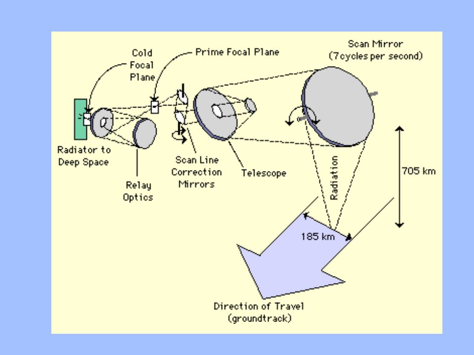
Cross-track Scanner “back and forth” motion of the foreoptics scans each ground resolution cell one-by-one Instantaneous Field of View (IFOV) of instrument determines pixel size Image is built up by movement of satellite along the orbital track and scanning acrosstrack
 of instrument determines pixel size Image is built up by movement of satellite along the orbital track and scanning acrosstrack")
30
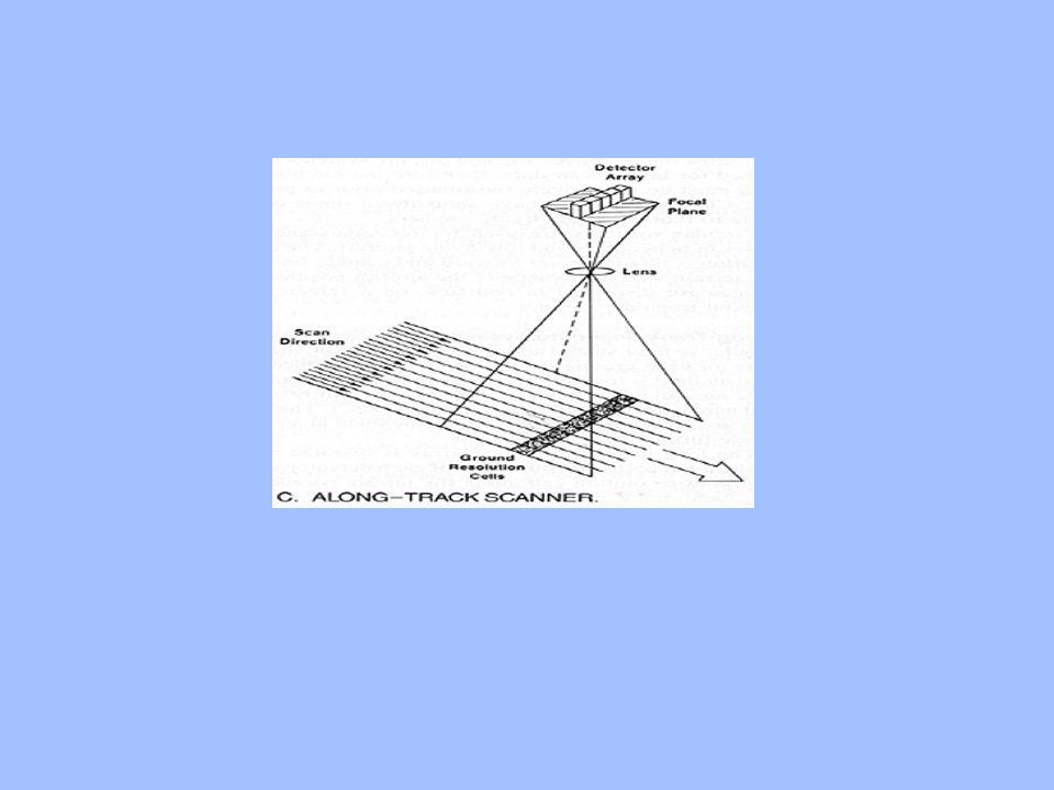
Along-track scanner (“Pushbroom) Linear array of detectors (aligned cross-track) – reflected radiance passes through a lens and onto a line of detectors Image is built up by movement of the satellite along its orbital track (no scanning mirror) Area array can also be used for multi-spectral remote sensing – dispersion used to split light into narrow spectral bands and individual detectors
 Linear array of detectors (aligned cross-track) – reflected radiance passes through a lens and onto a line of detectors Image is built up by movement of the satellite along its orbital track (no scanning mirror) Area array can also be used for multi-spectral remote sensing – dispersion used to split light into narrow spectral bands and individual detectors")
31
Scanning techniques n Vidicom Like television camera; “sees” everything at onceLike television camera; “sees” everything at once n Swinging Results in a zig-zag pattern of scanningResults in a zig-zag pattern of scanning n Spinning Satellite spins in order to create imageSatellite spins in order to create image n Pushbroom Multiple scanning elements, relies on forward motion of satelliteMultiple scanning elements, relies on forward motion of satellite

32
On-board recording and pre-processing Direct telemetry to ground stations – receive data transmissions from satellites – transmit commands to satellites (pointing, turning maneuvers, software updating Indirect transmission through Tracking and Data Relay Satellites (TDRS) Getting the Data to the Ground
 Getting the Data to the Ground")
Similar presentations


. Why TRMM? n Tropical Rainfall Measuring Mission (TRMM) is a joint US-Japan study initiated in 1997 to study.>")

 & X-band (w = 2.4 – 3.8 cm) IFSAR to acquire topographic data.>")


