Download presentation
Presentation is loading. Please wait.

1
THE GEOLOGIC AND GEOMORPHIC HISTORY OF THE APPALACHIAN FALL LINE IN SOUTH CAROLINA By Alicia Fischer

2
What is a Fall Line? Geomorphologic unconformity A high, crystalline area and a sedimentary coast Waterfalls and/or rapids Lack of knowledge

4
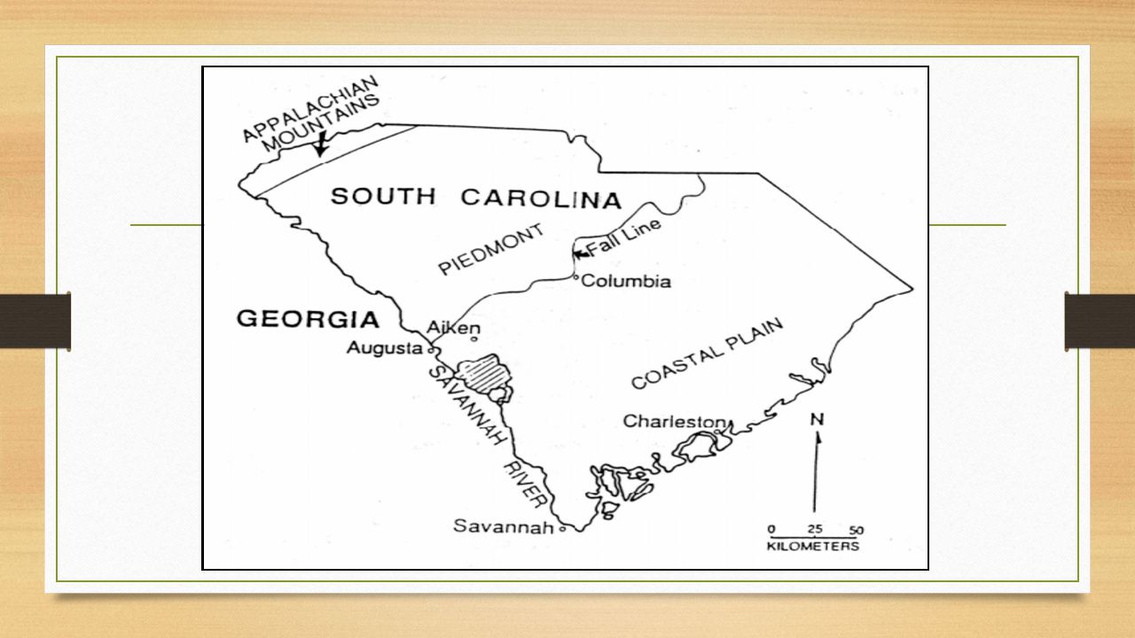
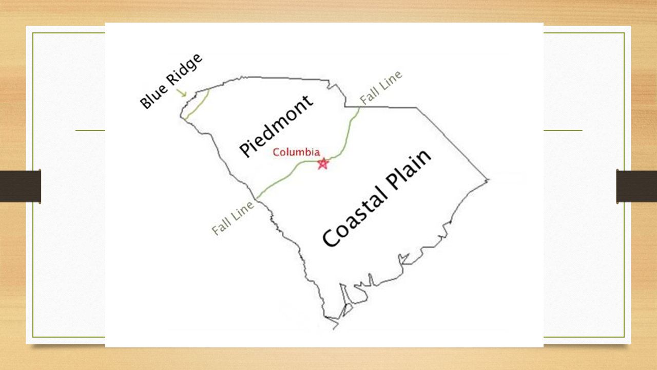
The Fall Line and SC The state most influenced by the fall line is South Carolina Divides SC in half (Columbia) Key role in the formation of the state
 Key role in the formation of the state")
6
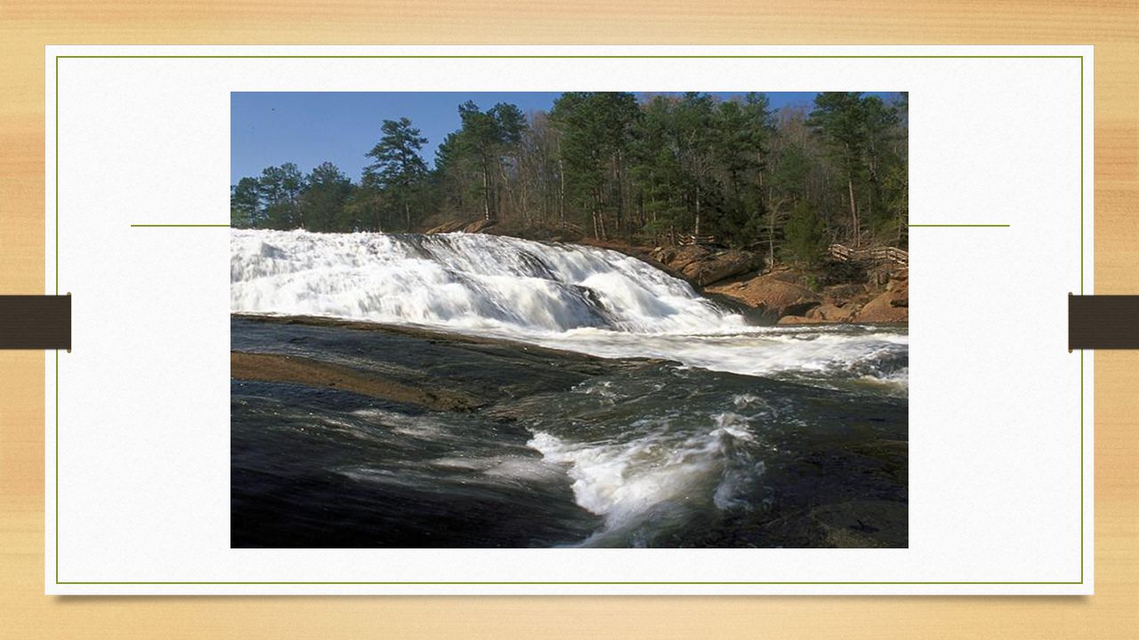
Characteristics of the Fall Line Spans 135 miles across SC The boundary between the Piedmont and the Coastal Plain Geologically – is made of bedrock Geomorphically – the last appearance of bedrock downstream Decrease in elevation from erosion (Piedmont vs Coastal Plain) Reliefs up to 300 feet in a short distance
 Reliefs up to 300 feet in a short distance")
7
Characteristics of the Fall Line (cont.) Quick deep drops disrupt river flow Rivers downcut to reach the low Coastal Plain High river gradients Rough character with rapids, gorges, and waterfalls Fluvial erosion (Piedmont) and deposition (Coastal Plain)
 Quick deep drops disrupt river flow Rivers downcut to reach the low Coastal Plain High river gradients Rough character with rapids, gorges, and waterfalls Fluvial erosion (Piedmont) and deposition (Coastal Plain)")
9
Geologic/Geomorphic History of SC: Pre-Cambrian Lava World 1.2 billion years ago, the first rocks created in what will become South Carolina The Grenville Orogeny created the eastern U.S. (SC’s Blue Ridge)
.")
10
Geologic/Geomorphic History of SC: Paleozoic Appalachian Orogeny: most important in SC’s formation Alleghanian orogeny formed the Appalachian Mountain Rapid uplift and deformation in Blue Ridge (crystalline) Half of present-day SC formed during the Alleghanian Orogeny (Piedmont)
 Half of present-day SC formed during the Alleghanian Orogeny (Piedmont)")
11
Geologic/Geomorphic History of SC: Mesozoic Reinvigorated Grenville and Appalachian materials Fault-prone rift basins (erosion) Reversed rivers to east (drainage divide) Waves of erosion deteriorated Appalachian peaks Rivers deposit sediment to Mesozoic shoreline (Coastal Plain)
 Reversed rivers to east (drainage divide) Waves of erosion deteriorated Appalachian peaks Rivers deposit sediment to Mesozoic shoreline (Coastal Plain)")
12
Geologic/Geomorphic History of SC: Cenozoic Sediment continually deposited by gravity and fluvial processes Epeirogeny across the Blue Ridge and Piedmont (erosion) Spans the Coastal Plain past Mesozoic shoreline (120 miles)
 Spans the Coastal Plain past Mesozoic shoreline (120 miles)")
14
Geologic/Geomorphic History of the Fall Line Resistant crystalline Blue Ridge (31 meters per million years) Piedmont metasedimentary peneplain (16 meters per million years) Flat sedimentary Coastal Plain (depositional area) Fall line lies between Piedmont and Coastal Plain Made of bedrock and was the old Mesozoic shoreline
 Piedmont metasedimentary peneplain (16 meters per million years) Flat sedimentary Coastal Plain (depositional area) Fall line lies between Piedmont and Coastal Plain Made of bedrock and was the old Mesozoic shoreline")
15
Fall Line Formational Hypothesis #1: Faulting Numerous faults lie in the fall line Small localized faults exist throughout SC Crosscut South Carolinian geological terrain Faulting exists only in a few sections of the fall line False Hypothesis

16
Fall Line Formational Hypothesis #2: Coastal Emergence/Erosion Coastal Plain once extended over Piedmont Rivers did not erode the Coastal Plain Regional disruptions created its hilly topography Through-flowing rivers caused Coastal Plain’s erosion Restricted to the coast and east of the Piedmont

17
Fall Line Formational Hypothesis #2: Coastal Emergence/Erosion (cont.) Research shows this coverage was too overstated Drainage patterns in some locations support this hypothesis Upland – dendritic Coastal Plain materials 40 km above the fall line
 Research shows this coverage was too overstated Drainage patterns in some locations support this hypothesis Upland – dendritic Coastal Plain materials 40 km above the fall line")
18
Fall Line Formational Hypothesis #3: Peneplain intersection and unconformity Two ancient peneplains crosscut The fall line is Piedmont’s stripped face Only Piedmont existed (uplifted and tilted into Atlantic) Deposition and extension of Coastal Plain on Piedmont Rivers flowed from the Piedmont to the Coastal Plain The erosional contact exposed bedrock
 Deposition and extension of Coastal Plain on Piedmont Rivers flowed from the Piedmont to the Coastal Plain The erosional contact exposed bedrock")
19
Fall Line Formational Hypothesis #3: Peneplain intersection & unconformity (cont.) Deep drilling into the Coastal Plain exposed the underlying Piedmont Coastal Plain depth extends from 0 feet to over 4,000 feet Hypotheses 2 and 3 explain fall line’s origin Figure 11-4, South Carolina “Fall Line ” (Odum et al., 2003)
 Deep drilling into the Coastal Plain exposed the underlying Piedmont Coastal Plain depth extends from 0 feet to over 4,000 feet Hypotheses 2 and 3 explain fall line’s origin Figure 11-4, South Carolina Fall Line (Odum et al., 2003)")
20
Relocation and Possible Disappearance (1) Fall line bedrock erodes between 6 and 9 meters per million years (2) Upland gravels above the fall line (3) Gradients show the fall line is stable Shifting plates and erosion/deposition in several million years (move FL) Next million years, the fall line should remain stable
 Fall line bedrock erodes between 6 and 9 meters per million years (2) Upland gravels above the fall line (3) Gradients show the fall line is stable Shifting plates and erosion/deposition in several million years (move FL) Next million years, the fall line should remain stable")
21
The fall line’s significance Historically, the fall line was important in navigation and settlement First noticed when traveling by boat Colonized area to control trade and transportation (Columbia) Potential for hydrologic power and irrigation from fall line’s rivers Farms and SC’s economy
 Potential for hydrologic power and irrigation from fall line’s rivers Farms and SC’s economy")
23
Pictures Cited http://www.virginiaplaces.org/regions/fallshape.html http://www.virginiaplaces.org/regions/fallshape.html Snipes et al., 1993 https://pangaeablues.wordpress.com/author/pangaeablues/ https://www.pinterest.com/xadams2/precambrian-hadean-4600-3800-miljoen-v-chr/ http://bullet-magnet.deviantart.com/art/Planet-Icarus-Erebosian-Eon-48325388 http://paristampablog.com/tag/paris-bassin/ http://www.rci.rutgers.edu/~schlisch/103web/NJcontext/ENAhistory.html http://www.rci.rutgers.edu/~schlisch/103web/NJcontext/ENAhistory.html http://www.gns.cri.nz/Home/Learning/Science-Topics/Earthquakes/Earthquakes-and-Faults http://en.wikipedia.org/wiki/Fall_line http://www.postandcourier.com/article/20150411/PC1002/150419855/1022/stand-strong-for-sc-coast Odum et al., 2013 http://www.georgiaencyclopedia.org/blog/2013/08/13/rolling-line

Similar presentations


 and composition of the landscape.>")


 and Piedmont regions, where waterfalls prevent further.>")


