Download presentation
Presentation is loading. Please wait.

1
A GIS-based comparison of pre- and post-lignite strip mine waters A Progress Report by L. Joy Mercier on Tuesday, November 22, 2011 *Luminant reclaimed land near Monticello Mine (Luminant, May 2011)
.")
2
Questions to Answer What is lignite, and why do we care? Where is the lignite in Texas? Where are the lignite mines in Texas? What are the hydrologic and hydrogeologic impacts of lignite surface (strip) mining? How can we use GIS to better understand the complex spatial and temporal relationships between mining and reclamation and changes in water quality or behavior?
 mining. How can we use GIS to better understand the complex spatial and temporal relationships between mining and reclamation and changes in water quality or behavior .")
3
Methods Library, Internet, and Online Database Research: – What is lignite, and who cares about lignite anyways? Research + GIS Mapping: – Where is the lignite in Texas? – Where are the lignite mines in Texas? – What are the hydrologic and hydrogeologic impacts of lignite surface (strip) mining? Analysis Using GIS Tools: – How can we use GIS to better understand the complex spatial and temporal relationships between mining and reclamation and changes in water quality or behavior?
 mining. Analysis Using GIS Tools: – How can we use GIS to better understand the complex spatial and temporal relationships between mining and reclamation and changes in water quality or behavior .")
4
What is lignite? Above: Lignite Coal (Photo by: Center for Applied Energy Research, University of Kentucky)
.")
5
Who cares about lignite? Lignite strip mine north of Laredo in Webb County, TX (photo by AirPhoto, Image #16387, taken on 4/29/1997)
.")
6
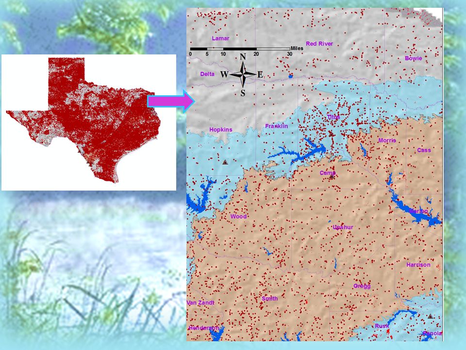
Where are the lignite mines in Texas?

7
Where is the lignite in Texas?

8
Where are the lignite mines in Texas?

9
What are the hydrologic and hydrogeologic impacts of lignite surface (strip) mining?
 mining")
10
Dewatering and rerouting surface water Changes from reducing to oxidizing conditions in the de-saturated overburden Changes in overburden permeability and hydraulic gradients Changes in water quality parameters Exploring “mining impact” questions via research methods:

11
Exploring the “mining impacts” questions via GIS methods:

12
Exploring the “mining impacts” questions via GIS methods: Future Research!!

14
How can we use GIS to better understand the complex spatial and temporal relationships between mining and reclamation and changes in water quality or behavior? Also future research!!!

15
More about future work: ArcGIS Tools No time to sleep! No time to eat (turkey)! Do more analyses! … Because there is always more that you can do in ArcGIS!
. Do more analyses. … Because there is always more that you can do in ArcGIS!.")
16
More about Lignite Mining in Texas: Cagle, M.F., 2007, Temporal and spatial sulfate variability in groundwater at a lignite mine, northeast Texas [M.S. thesis]: Austin, University of Texas at Austin, 269 p. Espey, Huston, and Associates, Inc., 1983, Impacts of Lignite Development in Texas: An Environmental Primer: Prepared for Texas Energy and Natural Resources Advisory Council, TENRAC/EDF-091, 89 p. Kaiser, Ayers Jr., & LaBrie, 1980, Lignite Resources in Texas: Bureau of Economic Geology, University of Texas at Austin, and Texas Energy and natural Resources Advisory Council, 55 p. Surface Mining and Reclamation Division, 1991, Information and Statistical Facts on Coal and Uranium Mining in Texas: Railroad Commission of Texas, 63 p. Venburg, L.C., 1983, Monitoring the effect of surface mining operations on the hydrologic regime: Ground Water Monitoring Review, v.3, pp.86-91.

17
Questions?

Similar presentations


 Geography is the study of locational and spatial trends about the earth’s surface, the objects found on it, and the.>")
>")


