Download presentation
Presentation is loading. Please wait.

1
Integrated Visual Design (IVD) Cam Campbell P.Ag. MBCSLA University of Reading Presentation - February 18 th 2002 The Bear Lake Integrated Visual Design Plan Case Study BC Ministry of Forests Forest Practices Branch Penticton Forest District

2
Context – Why Integrated Visual Design? Catalysts Strategic land and resource planning initiatives BC Forest Practices Code 1995 (et al) And now --- FRPA (2002) Issues Licensees avoiding VSA’s– Realization its not business as usual! Conventional forest planning approaches were not working well in VSA’s (short time horizons, poor designs, not optimising timber op’s etc.) Recognized an approach / tools required that addressed the visual design component in an integrated manner (e.g. functional considerations, etc resolved at same time.) Genesis of IVD Mof / Forestry Commission collaboration (Simon Bell et al)
 And now --- FRPA (2002) Issues Licensees avoiding VSA’s– Realization its not business as usual. Conventional forest planning approaches were not working well in VSA’s (short time horizons, poor designs, not optimising timber op’s etc.) Recognized an approach / tools required that addressed the visual design component in an integrated manner (e.g. functional considerations, etc resolved at same time.) Genesis of IVD Mof / Forestry Commission collaboration (Simon Bell et al).")
3
Integrated Forest Design - Antecedents Integrated landscape analysis methods (McHarg, Hill et al – 1960’s) Forestry Commission - Forest Landscape Design Process (Crowe, Lucas and Bell) USDA Forest Service - Landscape Analysis and Design Process (Diaz and Apostal) Total Chance Planning / IRM (various jurisdictions) BC Ministry of Forests - Integrated Visual Design / Total Resource Design Processes (Marc, Bell, Campbell, Rennie et al).
 Forestry Commission - Forest Landscape Design Process (Crowe, Lucas and Bell) USDA Forest Service - Landscape Analysis and Design Process (Diaz and Apostal) Total Chance Planning / IRM (various jurisdictions) BC Ministry of Forests - Integrated Visual Design / Total Resource Design Processes (Marc, Bell, Campbell, Rennie et al).")
4
The IVD Process Follows a classic landscape planning approach of setting objectives, inventory, analysis, design, evaluation and documentation / revisions. Incorporates TRD / Total Chance Planning concepts Considers all dimensions of landscape simultaneously (functional / economic / ecological / aesthetic) Incorporates both creative and analytical decision making processes Uses plan and perspective design methods simultaneously to aid in design / understanding for impacts
 Incorporates both creative and analytical decision making processes Uses plan and perspective design methods simultaneously to aid in design / understanding for impacts.")
5
The Bear Lake IVD Case Study

6
Aims 1.To test / evaluate the IVD process in action 2.To provide strategic direction for the long-term development / optimisation of timber resources adjacent to Bear Lake given visual and other constraints. Desired Outputs: 1 st pass harvest / landscape development concept that achieved visual quality and other HLP objectives

7
Project Context Institutional Context Situated in South Central BC, 20 km. from the City of Kelowna in the Okanagan Valley Area part of BC. Ministry of Forests Small Business Programme Land use / resource management governed by higher level plan (Okanagan LRMP) Broad range of recreational, visual, environmental, wildlife and timber resources and values. Plan assembled by Ministry of Forests team and consultant designer
 Broad range of recreational, visual, environmental, wildlife and timber resources and values. Plan assembled by Ministry of Forests team and consultant designer.")
8
Project Context 1600 ha. Planning area Visually sensitive steep, west facing slopes along lakeshore IDF / MS BGSZ NDT 3 (frequent stand initiating events) Extensive Pl and Fd Commercial recreation interests MoF recreation site Community Watershed Moose Winter Range Fish resources (stream and lake)
 Extensive Pl and Fd Commercial recreation interests MoF recreation site Community Watershed Moose Winter Range Fish resources (stream and lake).")
9
Project Context Viewpoint A (Rec. Site – North End of Bear Lake Viewing East Viewpoint D (South End of Bear Lake Viewing North)
.")
10
Phase 1:Setting Design Objectives

11
Higher Level Planning Direction derived primarily from Okanagan / Shuswap LRMP and FPC– this includes objectives relating to: Biodiversity / ecosystem function Recreation Forest Health Visual Landscape (VQO R-PR / M in backcountry) Fish and wildlife Access management Community water supply / quality Riparian management Timber development Other area specific objectives were identified by members of the design team. (e.g 1 st pass volume)
.")
12
Phase 2:Landscape / Resource Inventory Disassembling the Landscape 1.Inventory of Key Influences 2.Mapping 3.Visibility 4.Landscape Character

13
Abiotic, Biotic and Cultural Influences Forest cover (age class, species, volume, density, site index) Operability criteria Harvest criteria Biogeoclimatic zones Forest Health Natural disturbance types Recreation Visibility / landscape character Fish and wildlife habitat Terrain hazards Riparian influences Existing use Adjacent land uses Archaeology Access Slope Regulatory Community watershed Soils Stand dynamics Hydrology Aspect Trails Trap-lines
 Operability criteria Harvest criteria Biogeoclimatic zones Forest Health Natural disturbance types Recreation Visibility / landscape character Fish and wildlife habitat Terrain hazards Riparian influences Existing use Adjacent land uses Archaeology Access Slope Regulatory Community watershed Soils Stand dynamics Hydrology Aspect Trails Trap-lines")
14
Inventory / Mapping of Landscape Influences

15
Visibility Analysis

16
Landform and Landscape Character Analysis -

17
Phase 3:Landscape Analysis Defining Landscape Structure / Understanding Interactions Re-assembling the Landscape 1.Composite Constraints 2.Design Units 3.Opportunities and Limitations 4.Area Specific Issues / Objectives Strategies 5.Design Guidelines Often Known as the So What! Phase

18
Composite Constraints Aim - to define broad patterns in operability -- the fixed / variable aspects of landscape

19
Composite Constraints Design Planning Units Aim – Organize inventory information in a meaningful manner – identifying areas of relatively homogeneous site characteristics and then describing each in terms of inventory information Forms the basis for an Opportunities and Limitations analysis

20
For each Design Unit, interactions among landscape influences are made explicit in terms of opportunities or limitations to development Suggests how landscape design is constrained / enhanced by landscape influences Begins to suggest strategies / ideas for how specific areas might develop and change over time Opportunities and Limitations

21
Design Issues, objectives and strategies specific to each design unit were identified. These: 1.formed the basis of the design programme; 2.guided the scope and nature of the design exploration occurring in subsequent phases of the project. 2.Expressed strategies for addressing issues / objectives Issues, Objectives and Strategies

22
Phase 4:Landscape Design Phase Translating Design Direction into Physical Form

23
Design Concept Composite Constraints Conceptual Design Diagram Documents the loose ideas about how the area might develop formed during the analysis phase Serves as a bridge between the analysis and detailed design phases Expressed quickly as bubble diagrams / sketch plans. – includes annotation about harvest and silvi. Systems, access, levels of retention within stands etc.

25
Harvest Design Studies The issues / strategies identified in the previous stage informs the design exploration of individual cut-blocks – The Design Concept provides a broad framework within which this occurs Aim – design of a complete pattern of harvest shapes to a reasonable level of resolution and detail (paper location / design) It is an iterative process involving much trial and error – quickly exploring and testing ideas to arrive at a balanced solution
 It is an iterative process involving much trial and error – quickly exploring and testing ideas to arrive at a balanced solution")
26
Unit Design Guidelines When designing the individual harvest units, ideas form about how to employ retention patches, boundary configuration etc. to address visual quality or other objectives. These are captured as design guidelines that can assist the engineer in their detailed paper / field design and layout.

27
Conceptual Harvest Design (Total Chance) Ultimately, a workable pattern of harvest units is developed to a reasonable level of detail (scheduling, boundaries, possible access, harvest system, outputs) This can be modeled and evaluated to test its fitness in the context of project objectives
 Ultimately, a workable pattern of harvest units is developed to a reasonable level of detail (scheduling, boundaries, possible access, harvest system, outputs) This can be modeled and evaluated to test its fitness in the context of project objectives")
28
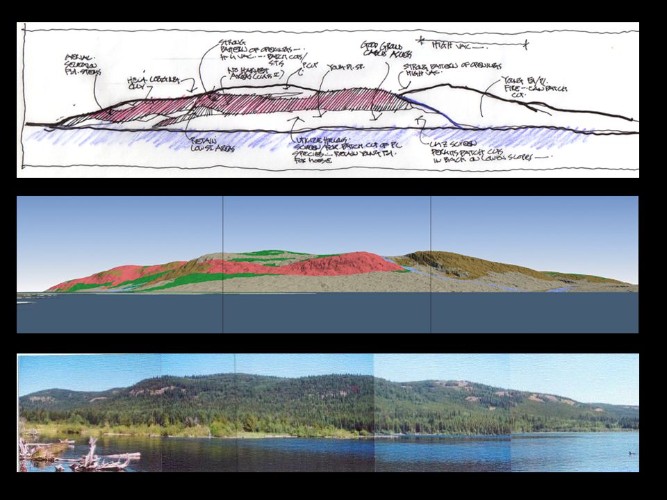
Evaluating and Testing the Design

29
1 st Pass Development

30
Summary of IVD Relationship Between Phases and Steps

31
Observations and Summary – The Good Organizes, summarizes and manages large amount of information in meaningful manner Design decisions occur in an integrated manner rather than the traditional approach of “taking the landscape to bits” and then prescribing an action for each element (as per current practice); - Design evolves from landscape / cultural influences Reduces complexity of problem by breaking the larger problem down into smaller more manageable problems which, when solved, contribute to the resolution of the whole Process is transparent and graphic allowing for public / agency / NGO scrutiny Process is versatile and can be employed at varying scales – from site to landscape scale Well suited to FRPA structure (strategies and results) Provides managers with greater operational flexibility in constrained areas by identifying all possible development opportunities (in context of resource / regulatory constraints)
; - Design evolves from landscape / cultural influences Reduces complexity of problem by breaking the larger problem down into smaller more manageable problems which, when solved, contribute to the resolution of the whole Process is transparent and graphic allowing for public / agency / NGO scrutiny Process is versatile and can be employed at varying scales – from site to landscape scale Well suited to FRPA structure (strategies and results) Provides managers with greater operational flexibility in constrained areas by identifying all possible development opportunities (in context of resource / regulatory constraints)")
32
Observations and Summary – The Challenging Demands longer term thinking Requires visual communication and modelling technology / expertise Requires expertise that is not traditionally part of the profession of forestry (e.g. design methods) – suggests additional expertise required (e.g. Larcs) .
 – suggests additional expertise required (e.g. Larcs) ..")
Similar presentations


 Focuses on research of the coupled dynamics of social- ecological systems (SES) and the translation of.>")


 Rm. 2226, Bovey Building x53065 Dr. Rob Corry (Module.>")
 LEVEL ADMINISTRATION STATE LEVEL ADMINISTRATION.>")

 Hoover Professor of Forestry 494-3580 743-4120>")


