Download presentation
Presentation is loading. Please wait.

1
Investigation of Seasonal Hydrology and Variable Source Areas within Regions of Ontario Ramesh Rudra (R.P. Rudra, B. Gharabaghi, S, Gregori, W.T. Dickinson) (S.I Ahmed, A Singh, M. Ahmed, J. Whiteside) (K. Chapi, M. Khayer and R. Sharma) (Summer Students) School of Engineering University of Guelph Guelph, Ontario N1G 2W1
 (S.I Ahmed, A Singh, M. Ahmed, J. Whiteside) (K. Chapi, M. Khayer and R. Sharma) (Summer Students) School of Engineering University of Guelph Guelph, Ontario N1G 2W1.")
2
Connection to NMJRP Maximum liquid loading rates Major emphasis –Seasonal hydrology Relationship with –Slope classes –Shallow soils over bedrock or groundwater –Tile-drained lands –N Index –P Index

3
Objectives 1)To complete a comprehensive literature review on spatial and seasonal dimensions (variations) of Ontario hydrology, including environmental factors influencing runoff generation. 2)To quantify seasonal variability in surface runoff, base flow, and tile flow and their relationship with soil, land use and topographic characteristics of the watershed in various physiographic regions. 3)To quantify seasonal variations in soil hydraulic properties and their relationships with hydrologic soil groups, and to develop an improved procedure for classification of soils into hydrologic soil groups. 4)To develop procedures (experimental and model) to map surface runoff contributing areas in a watershed.
To quantify seasonal variability in surface runoff, base flow, and tile flow and their relationship with soil, land use and topographic characteristics of the watershed in various physiographic regions. 3)To quantify seasonal variations in soil hydraulic properties and their relationships with hydrologic soil groups, and to develop an improved procedure for classification of soils into hydrologic soil groups. 4)To develop procedures (experimental and model) to map surface runoff contributing areas in a watershed..")
4
Research Focus – Seasonal Hydrology Analysis of stream flow in various regions. 190 watersheds. Instrumentation and monitoring of a watershed for runoff contributing area for 14 rainfall events during summer and fall. Rainfall simulation and infiltration field experiments at 5 sites covering 4 hydrologic soil groups for summer, spring, and fall Only material used is water Time, t Discharge m 3 /s Precip mm/hr A B C DE Direct Runoff Baseflow

5
Methodology - Objective 1 Comprehensive bibliography on analysis of hydrology Precipitation, Temperature, ET. Annual water budget, Seasonal water budget Slow response (Base flow), Quick response (Surface runoff) Land use and tile drainage Effect of wetlands/riparian zones Identification of the impact of physiographic and climatic characteristics Identification of research gaps for source water protection and nutrient management All conservation authorities in the province were contacted
, Quick response (Surface runoff) Land use and tile drainage Effect of wetlands/riparian zones Identification of the impact of physiographic and climatic characteristics Identification of research gaps for source water protection and nutrient management All conservation authorities in the province were contacted.")
6
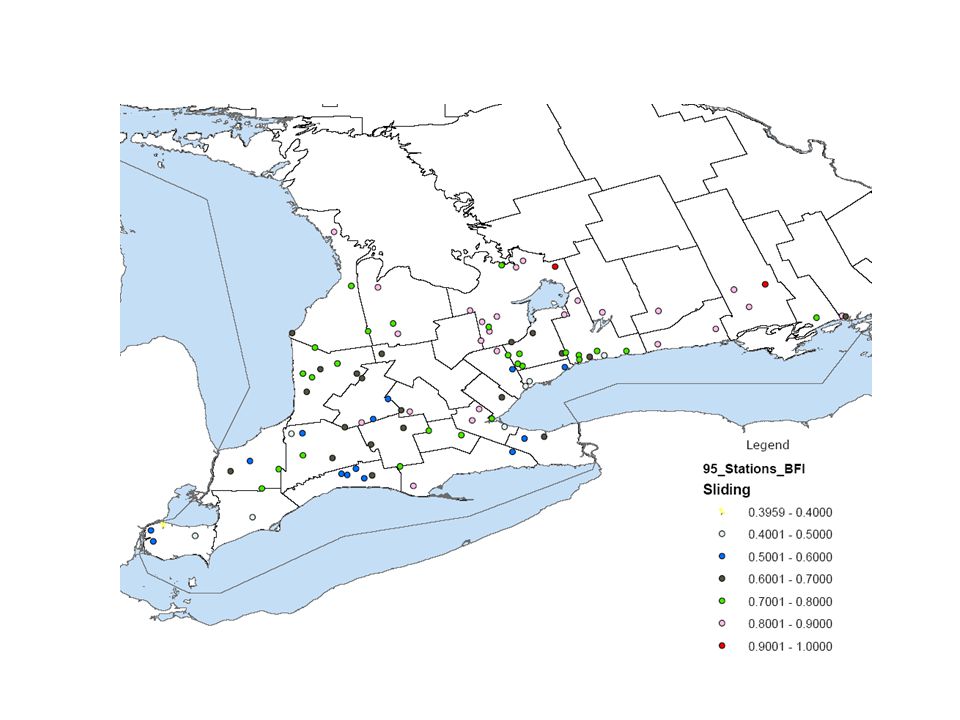
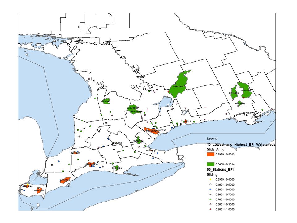
Methodology - Objective 2 Stream flow variations analysis (190 watersheds) with respect to Precipitation Annual, seasonal, and monthly runoff coefficients, base flow index, and tile flow index. Relationship of runoff coefficients, base flow index, and tile flow index watershed characteristics Results presented are for example watersheds. Tile drainage analysis is still in progress. Relationship with watershed characteristics is still in progress.. Base Flow Separation Methods Digital filter method PART method UKIH method Local minima method Sliding base method Fixed base method

7
Comparison of Base Flow Separation Methods

10
Base Flow Index vs Watershed Characteristics Examples WatershedDrainage Characteristics Hydrologic Soil Group BFI LITTLE River at WindsorP(95%)D(95%)0.40 RUSCOM River at RuscomP(94%)D(81%)0.46 TURKEY Creek at WindsorP(87%)D(86%)0.50 DUFFINS Creek at AjaxW(82%), I(27%)A(21%), B(57%)0.72 EAST HUMBER River near Pine GrioveW(63%), I(28%)B(14%), C(57%)0.73 EAST HUMBER River at King CreekW(69%), I(22%)B(27%), C(52%)0.74 NOTTAWASAGA River near AllistonW(83%)A(63%), B(19%)0.83 HUNSBERGER Creek near Wilmot Centre W(83%)A(80%)0.84 PINE River near EverettW(91%)A(40%),B(41%)0.88
D(95%)0.40 RUSCOM River at RuscomP(94%)D(81%)0.46 TURKEY Creek at WindsorP(87%)D(86%)0.50 DUFFINS Creek at AjaxW(82%), I(27%)A(21%), B(57%)0.72 EAST HUMBER River near Pine GrioveW(63%), I(28%)B(14%), C(57%)0.73 EAST HUMBER River at King CreekW(69%), I(22%)B(27%), C(52%)0.74 NOTTAWASAGA River near AllistonW(83%)A(63%), B(19%)0.83 HUNSBERGER Creek near Wilmot Centre W(83%)A(80%)0.84 PINE River near EverettW(91%)A(40%),B(41%)0.88")
11
Methodology – Objective 3 Reclassification of Hydrologic Soil Groups Fabricated and evaluation of rainfall simulators. Rainfall simulation experiments at five locations, covering four hydrologic soil groups. Infiltrometer experiments. Monitoring of rainfall, surface runoff, soil moisture, topographic and land use characteristics. –Mostly summer season –Some spring and fall seasons

12
Field Experimental Sites

13
Variation in soil Hydraulic Properties The data from the field experiments indicated range of variability much broader than is "useful" for "within-field" decision-making. for nutrient use efficiency. These data will not yield realistic trends to classify the soil into more detailed soil groups. More field data is required for improved hydrologic soil group classification.

14
Methodology – Objective 4 Mapping of contributing area (Variable Source Area) Experimental approach Development and evaluation of runoff sensors and wireless recording system. –Evaluation in the laboratory. –Evaluation in the field. Installation of runoff sensors Monitoring of 14 rainfall events Analysis of the experimental data for VSA. Modeling Approach Development of VSA model Evaluation of VSA model

15
Development and Evaluation of Runoff Sensors Long Antenna Temperature Fluctuations Low Accuracy Smaller and Shorter Antenna No temperature reading More Accuracy 15 Testing in the laboratory Testing in the Field Calibration for backwater effects Field Installation

16
An Example of Data Collected Eight pressure sensors, soil moisture sensors and V-notches were installed in the watershed. Data reported is from runoff sensors Fourteen rainfall events were recorded during Summer and Fall 2008 July 30, 08 August 10, 08 August 18, 08

17
An Example of Variable Source Area Modeling 17 The July 22 nd, 2008 rainfall event is selected as an example for Variable Source Area (VSA) modeling.
 modeling.")
18
An Example of Variable Source Area Modeling 18

19
Contributing to NM Science The objectives of this study have evaluated the seasonal and spatial variability of hydrology, an issue relating to source water protection and nutrient management. The extensive literature review provided a sound base for the direction of the various field and computer modelling techniques for source water protection and nutrient management. Large (Provincial) Scale Identified for the non-regulated watersheds (190) which are predominantly either surface runoff or base flow. –This will be helpful for N and P index
 Scale Identified for the non-regulated watersheds (190) which are predominantly either surface runoff or base flow. –This will be helpful for N and P index.")
20
Contributing to NM Science Medium (Large Watershed) Scale Linkage between surface runoff, base flow, tile flow (in progress) components of the stream flow with precipitation characteristic and watershed characteristics. Medium (Small watershed and Field) Scale Development of an innovative field technology to identify and quantify areas contributing surface runoff to the stream (VSA) from a field or a small watershed. –Helps to fill gaps to understand and enhance knowledge of Ontario seasonal hydrology. Development of an approach to model area contributing surface runoff to the stream (VSA) from a field or a small watershed. –Developed experimental technology and modeling approach require evaluation at more locations.
 Scale Development of an innovative field technology to identify and quantify areas contributing surface runoff to the stream (VSA) from a field or a small watershed. –Helps to fill gaps to understand and enhance knowledge of Ontario seasonal hydrology. Development of an approach to model area contributing surface runoff to the stream (VSA) from a field or a small watershed. –Developed experimental technology and modeling approach require evaluation at more locations..")
21
Contributing to NM Science Small (Field or Plot) Scale Development of experimental methodology for improved classification of hydrologic soil groups. –Range of variability much broader than is "useful" for "within-field" decision-making. for nutrient use efficiency. –More field data is required for improved hydrologic soil group classification. The observed field data, extensive watershed based hydrological analysis and the developed variable source area model are promising findings. The outcome of this research is a significant contribution for source water protection and nutrient management.

Similar presentations
>")


>")


