Download presentation
Presentation is loading. Please wait.

1
CENSUS GEOGRAPHY WORKSHOP Tim McMonagle Geography Los Angeles Regional Census Center 1

2
Topics Census Geography Demographic Data MAF/TIGER Data Base (MTDB) TIGER/Line Files Joining TIGER and Demographic Data Count Question Resolution Program Future for MTDB? New American Fact Finder Mapping 2

4
Census Geography 4

5
The Role of Geography in the Decennial Census Geography provides the framework for the collection, tabulation, and dissemination of Census Data Success of the Census rest not only on collecting data, but also linking data to correct geographic areas Anyone using Census Data should have some knowledge of Census Geography

6
Hierarchy of Census Geography

7
The Census Block What is it? - The smallest geographic area defined for data collection and tabulation by the Census Bureau How is it determined? -Based on the type of features contained in the Census Bureau’s Geographic Database –TIGER

8
Small Area Census Geography

9
Urban/ Rural Classification

10
Urban / Rural For the 2010 Census, an urban area will comprise a densely settled core of census tracts and/or census blocks that meet minimum population density requirements, along with adjacent territory containing non-residential urban land uses as well as territory with low population density included to link outlying densely settled territory with the densely settled core. The Census Bureau identifies two types of urban areas: -Urbanized Areas (UAs) of 50,000 or more people -Urban Clusters (UCs) of at least 2,500 and less than 50,000 people. “Rural” encompasses all population, housing, and territory not included within an urban area.
 of 50,000 or more people -Urban Clusters (UCs) of at least 2,500 and less than 50,000 people. Rural encompasses all population, housing, and territory not included within an urban area..")
11
Urban / Rural (Urban Areas) – Schedule November 22, 2010 – Public comment period ends for proposed criteria published in Federal Register –http://www.census.gov/geo/www/ua/urbanruralclass.html First quarter of 2011 – Final criteria published in Federal Register March-December 2011 – delineation Spring 2012 – Federal Register notice listing final Urban Areas April 2012 – Urban/Rural TIGER/Line Shapefiles October 2012 – SF-1 Urban/Rural Update Late-2013 – ACS publishes data for 2010 Urban Areas 11
 – Schedule November 22, 2010 – Public comment period ends for proposed criteria published in Federal Register – First quarter of 2011 – Final criteria published in Federal Register March-December 2011 – delineation Spring 2012 – Federal Register notice listing final Urban Areas April 2012 – Urban/Rural TIGER/Line Shapefiles October 2012 – SF-1 Urban/Rural Update Late-2013 – ACS publishes data for 2010 Urban Areas 11")
12
Urban / Rural Additional information and a link to the Federal Register announcement is at: http://www.census.gov/geo/www/ua/2010u rbanruralclass.html

13
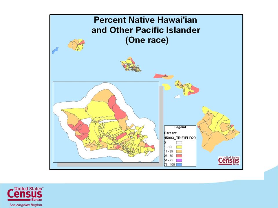
Changes in Hawai’i Census Geography for 2010

14
2010 Census Tract Criteria New Census Tracts Coding Series 9400-9499 Any tract with a majority of population and/or area on Hawaiian Home Lands 9800-9899 Special Land Use tracts 9900-9999 Water Census Tracts

17
New Census Designated Places for 2010 Hawai’i County Discovery Harbour Waiohinu Honolulu County East Honolulu* Kalaeloa Kapolei Ko Olina Mililani Mauka Ocean Pointe* Urban Honolulu* Waikele West Loch Estate Kauai County Haena Wainiha Maui County Keokea Kula Launiupoko Mahinahina* Makena* Manele Olinda Olowalu Ualapu’e Wailea*

20
Census Statistical Data 20

21
21 Accessing Demographic Data

22
22

23
Legacy American Fact Finder

24
24

25
Census Data Geographically Referenced 25

26
New American Fact Finder

27
New American Fact Finder Download 27

28
GIS Ready

29
2010 Census Advance Group Quarters Summary File

30
Advance Group Quarter Summary File An early version of Table P-42 from the 2010 Census Summary File 1, showing seven types of group quarters Institutional Group Quarters - Adult correctional facilities - Juvenile correctional facilities - Nursing facilities - Other institutional facilities Non-institutional Group Quarters - College/University student housing - Military quarters - Other non-institutional facilities No characteristics of the group quarters are provided.

31
Advance Group Quarters Summary File (Cont.) Early release for use in Redistricting and the Count Question Resolution program. Table is only available via the FTP site. Flat ASCII files by state Provide Microsoft Access shells to help with importing and extracting the data. Link to files and information about the files at the Redistricting Data Office data site: http://www.census.gov/rdo/data/

33
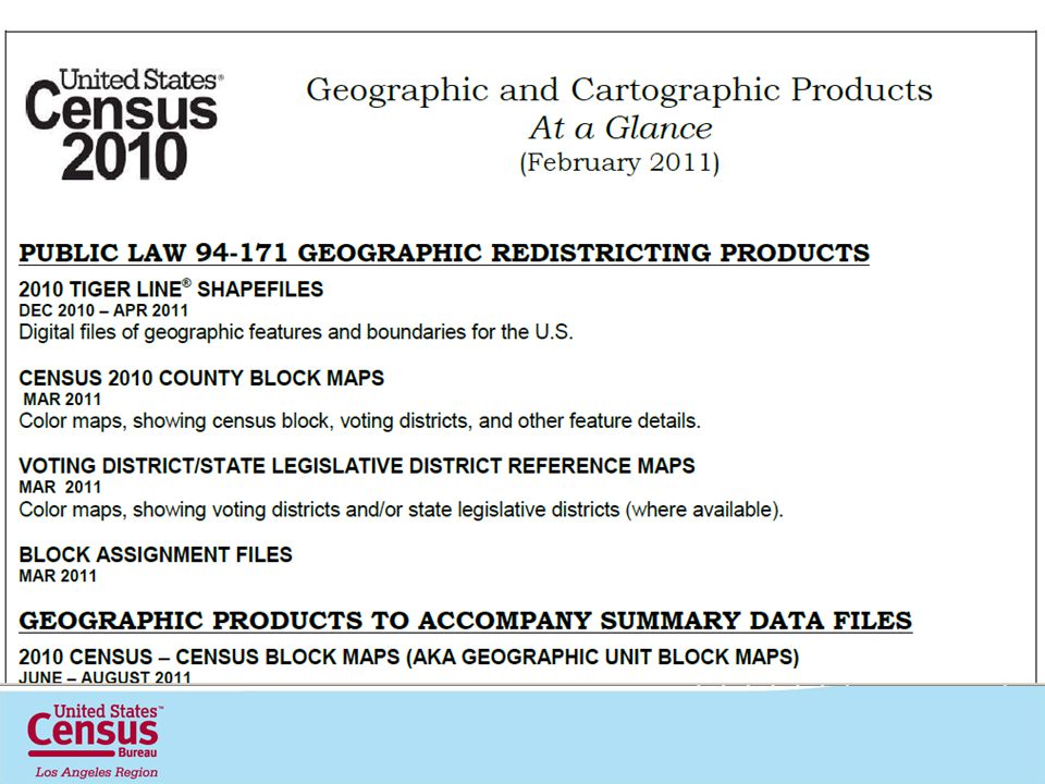
2010 Census Geographic Products

35
TIGER/Line Shapefiles 35

36
36 MAF/TIGER Data Base (MTDB) Replaces and combines Master Address File (MAF) and Topologically Integrated Geographic Encoding and Reference (TIGER) system databases Nationwide – not divided by county Oracle Spatial 10g database
 Replaces and combines Master Address File (MAF) and Topologically Integrated Geographic Encoding and Reference (TIGER) system databases Nationwide – not divided by county Oracle Spatial 10g database")
37
37 MAF/TIGER Accuracy Improvement Program Aligning the MAF/TIGER database with GIS/Imagery maintained by state/local/tribal partners/federal/private in order to implement more programs in a digital environment Improve spatial accuracy to allow the Census to use GPS handheld devices to collect data accurately Support the Administrations Geospatial One Stop e- government initiatives, make data publically available

38
Role of TIGER Assignment of location codes to addresses for data collection Geographic structure for tabulation and publication Cartographic products to support field operations, participant programs, collection and publication

39
What is TIGER? Topologically Integrated Geographic Encoding and Referencing TIGER Content Streets and their names Lakes, streams, and their names Railroads Geographic entity boundaries, names, and codes (for governmental units, census tracts, census blocks, etc.) Housing unit locations Key geographic locations (for airports, schools, etc.) ZIP Codes and address ranges (for streets with city-style addresses). A “digital map” (geographic data base) of the entire United States, Puerto Rico, and the associated Island Areas 39
 Housing unit locations Key geographic locations (for airports, schools, etc.) ZIP Codes and address ranges (for streets with city-style addresses). A digital map (geographic data base) of the entire United States, Puerto Rico, and the associated Island Areas 39.")
40
Basic TIGER Topology

41
41 TIGER Structure

42
What are TIGER/Line Shapefiles? Extracts of selected geographic and cartographic information from MTDB. Nationwide coverage Contains no sensitive data Are designed for use with GIS Contains geographic linear, areal, and point features, including attribute information Geographic entity boundaries The legal and statistical areas for which Census tabulates data 42

43
File Naming Convention The name of each file is: tl_2010_ _ _ tl- TIGER/Line 2010- version extent - 2 digit state FIPS code - 5 digit state county FIPS code layer- type of geography or feature 10 at the end = 2010 census geography 00 at the end = 2000 census geography ext – file extension 43

44
TIGER Release Schedule

45
Available Layers 45

46
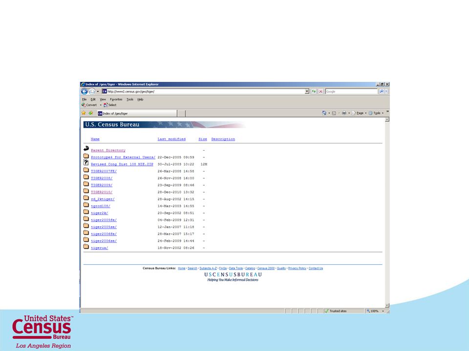
Accessing TIGER/Line Shapefiles 46

47
Select Correct Version of TIGER/Line 47

48
48

49
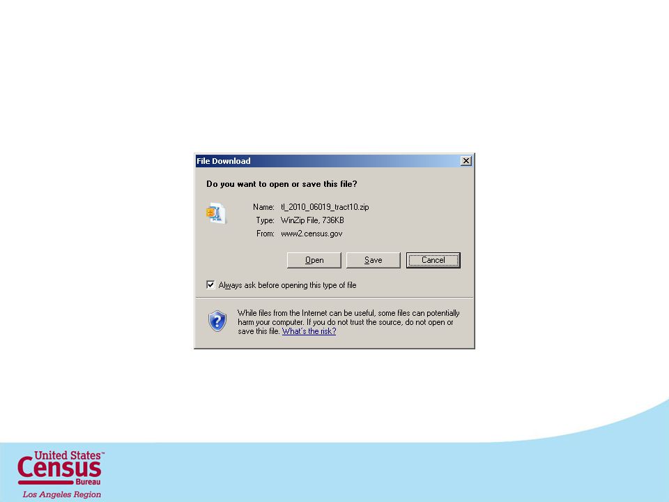
Download using Web interface

53
Download by type using FTP

55
55

57
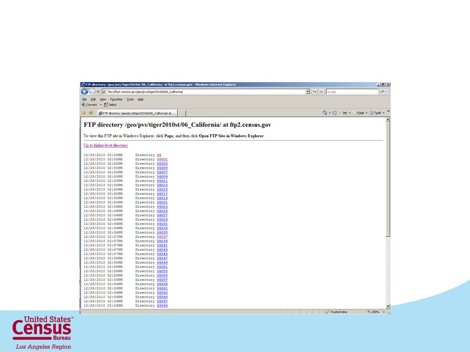
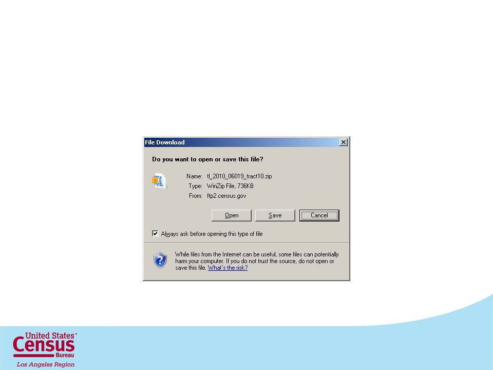
Download by State

61
http://www2.census.gov

67
Joining TIGER and Census Statistical Data 67

68
Attribute Tables

69
Join Function

71
2010 Count Question Resolution Program General Program Information

72
CQR Summary Scope Timing Challenge Types Documentation Requirements Challenges Results - Successful -Unsuccessful

73
Scope The Census Bureau’s 2010 Census Count Question Resolution (CQR) Program provides state, local, and tribal officials, or their designated representatives, in the United States and Puerto Rico a process to challenge the census counts of housing units, group quarters, and group Quarter population. 73

74
Scope Program will not change Reapportionment, Redistricting, or published counts. If as a result of a challenge a correction is required each affected entity will receive a letter certifying a population change and an errata will be posted to our web site. The Census Bureau will research and,if verified, correct the counts for: -Census Designated Places in Hawaii and Puerto Rico only. -Hawaiian Home Lands (submitted by a state official). 74
. 74.")
75
Timing June 1, 2011- June 1, 2013-Challenges can be submitted September 2013 all challenges must be resolved 2010 Data Available for Review -Redistrict Data Available -Advance Group Quarter Population Summary Files Available -May 2011- Demographic Profiles -June-Aug 2011- Summary File 1

76
Challenge Types Boundary- a governmental unit believes the Census Bureau has placed a jurisdictional boundary(s) of a functioning governmental unit may be in the wrong location that was legally in effect on January 1, 2010. Geocoding- a governmental unit believes that the Census Bureau has placed living quarters in the wrong location, within the wrong census block or larger Census Geography. Coverage/Processing- a governmental unit believes that the Census Bureau enumerated specific living quarters during the 2010 Census process, but the living quarters were either incorrectly added or deleted during the processing of the data.

77
Documentation Requirements Specify whether the challenge disputes the location of a governmental unit boundary and/or the number of housing units and/or group quarters population and: Boundary Disputes: Submit maps with legal boundaries as of January 1, 2010. Geocoding Error: Identify the specific geography and include a list of addresses as of April 1, 2010. Housing Unit Challenge: Identify the specific geography and include a list of residential addresses as of April 1, 2010. Group Quarter Challenge: Identify the specific geography and a complete address list for the GQ unit(s) present on April 1, 2010.
 present on April 1,")
78
Documentation Required (continued) Maps - Digital submissions using TIGER/Line -2010 Census PL 94-171 County Block -2010 Census Block -Boundary and Annexation Survey - Must provide a map spot for any challenged housing unit or group quarters. Address lists -Template from Census Web site & others -City-style -Non-city-style

79
Challenge Results Successful -Corrections sent to all affected jurisdictions -Corrections reflected in the base for post- census population estimates -Changes updated in the Master Address File/TIGER database -Changes documented through errata on AFF

80
Challenge Results Unsuccessful -Census will maintain documentation for future address file update work and no changes to data or geography are made. -If due to insufficient documentation, challenger is asked to provide more information.

81
CQR Information about the program can be found at: http://2010.census.gov/2010census/about/ cqr.php http://2010.census.gov/2010census/about/ cqr.php Count Question Resolution Brochure FAQ Federal Register Notice Address list templates

82
CQR Contact Count Question Resolution Program Decennial Management Division U.S. Census Bureau Washington, DC 20233 CQR Branch Phone: 301-763-9329 CQR E-mail: dmd.cqr@census.gov

83
The Future for TIGER 83

84
Geographic Support System Proposed Initiative : FY 2011 and Beyond 84

85
The Geographic Support System Initiative –What is it? An initiative before Congress to increase our base funding for improving the addresses in our Master Address File –Why is it important ? A response to stakeholder and oversight recommendations to update and maintain our address and spatial data with a special focus on rural areas, group quarters and Puerto Rico –What does it involve? An integrated program of improved address coverage, continual spatial feature updates, and enhanced quality assessment and measurement through partnerships –Who are the major players? US Census Bureau with, federal, state, local, tribal, and contractor partners

86
Why do we need the GSS Initiative? Between 2003 – 2008 we worked with you and other partners to update and improve the positional accuracy of TIGER That effort was very success The MAF/TIGER Accuracy Improvement Project was a significant investment that we want to build upon Now focus is on improving our address coverage and quality and maintaining the spatial data

87
A Shift in Focus for the 2020 Census From a complete address canvassing to a targeted address canvassing –Hinges on establishing an acceptable address list for each level of government What defines “acceptable” will be a partnership collaboration between government partners and the Census Bureau 87

88
Outside experts delivered 5 reports: –The State and Anticipated Future of Addresses and Addressing –Identifying the Current State and Anticipated Future Direction of Potentially Useful Developing Technologies –Measuring Data Quality –Use of Handheld Computers and the Display/Capture of Geospatial Data –Researching Address and Spatial Data Digital Exchange Ongoing GSS Work Contracting Research & Development

89
Ongoing GSS Work GEO-lead Census Bureau Working Groups Working groups, comprised of GEO, staff from other Census Bureau divisions (ACQ, ACS, DID, DIR, DMD, DSCMO, DSD, DSSD, FLD, GOVS, NPC, OAES, POP, RDO, TMO), and other federal agencies (USGS, NOAA NGS, USPS) were formed to address specific aspects of the GSS Initiative
, and other federal agencies (USGS, NOAA NGS, USPS) were formed to address specific aspects of the GSS Initiative")
90
GSS Working Groups –Project and Contract Management –Policy –Research and Development –Quality, Assessments/Evaluati ons –Address Coverage and Sources – Feature Coverage and Sources – Partnerships – MAF/TIGER Integration/Linkage – Geocoding – Global Positioning Systems (GPS) 90
 90")
91
Progress of GSS Working Groups FY2011 focus is research and development activities Working groups are: –Developing standards that reflect our requirements –Evaluating our current data –Determining how partners will contribute data –Exploiting technology

92
For the Geographic Support System Initiative to be Successful Partners are important –SDC/FSCPE/CIC –Federal, state, local, and tribal governments –Commercial vendors (data providers) Working relationships must be: –Least intrusive –Most efficient –Ensure complete and quality data
 Working relationships must be: –Least intrusive –Most efficient –Ensure complete and quality data")
93
Tim McMonagle Geography Los Angeles Regional Census Center U. S. Census Bureau Timothy.william.mcmonagle@census.gov 818-717-6701 93

Similar presentations


 Discussion FY 2011 Update Tim Trainor February 16, 2011.>")
 U.S. Census Bureau Geography Division & National Processing Center.>")
 Kevin Holmes, Geographer US Census Bureau: Philadelphia Regional Office.>")

 Indiana GIS 2005 Conference March 10, 2005 Indianapolis, Indiana.>")


 Partnership Program Donna Bullock U.S. Census Bureau 404-331-1339 November 2,>")


 Partnership Program Update for the State Data Center Leads September 19, 2012.>")


