Download presentation
Presentation is loading. Please wait.

1
Yardangs on MARS!!! Period: 1 Big bang theory Amanda Hosino Christianne Jullian Jessica Luong Kelli Oyasato Leiala Okuda Megan Inouye-Ng

2
Research Question Where are the most Yardangs located? Why is our science question important? Our science question is important because then, it will show us the clues to where Yardangs are located and we can find similarities between Earth and Mars. Why is your science question interesting? Our science question is interesting because it lets us try to figure out where we could find various places that contains Yardangs.

3
Hypothesis If there is an area that has lots of erosions…then the most Yardangs would be found there…because Yardangs are found on surfaces that erode easily.(everyones hypothesis) If Yardangs are formed from sand particles blown in the wind…then it would be found where sand storms occur…because their found on surfaces that erode easily. (Megan's hypothesis)
.")
4
Methods Space craftNASA’s Mars Odyssey CameraTHEMIS Camera Image TypeVisible Images- to see details within the crater MOLA- to see context of image and depth Geologic Features StudiedTopic: Yardangs. Yardangs matches our research question because we want to know where we can find the most Yardangs. Research Question: Where are the most Yardangs located? Geologic Regions we focused on All of Mars.

5
Methods Website list: http://themis.asu.edu Data collection steps on site: 1. Go to the http://themis.asu.edu website;http://themis.asu.edu 2. Click on the “image gallery” 3. Click on THEMIS image by topic 4. Click on Wind/Dust 5. Look for pictures of Yardangs Image ID #- Latitude/ Longitude- Misc. Data-

6
Methods Sample size120 THEMIS Images used to gather data Categories of data to be collected and “Why” Image ID # - We need to know the Image ID # because it would be hard to find a picture without it. We need it for our bibliography too. The Image ID # also identifies each image from each other. Latitude/ Longitude – We need to know the latitude and longitude of the Yardang images so we can find the exact location of it. Misc. Data – To record any other interesting information not warranted by our necessary data categories but certainly important to our study MeasurementsPicture diameter- rough estimation relative to image parameters based on THEMIS camera’s visible image range of 18km x 30km

7
Hypothesis Christianne -If… there wasn’t any air, no wind, and no sand… -Then… there wouldn’t be any yardangs -Because… for yardangs to form, you need wind and sand. Megan -If…yardangs are formed from sand particles blown in the wind.. -Then…it would likely be found in a sandstorm, or windy areas -Because…their formed with lots of wind.

8
Methods

9
Background Information

10
Bibliography http://www.google.com/imgres?q=yardangs&hl=en&safe=stri ct&sa=X&gbv=2&tbm=isch&prmd=imvns&tbnid=eHB1uewa9r QWZM:&imgrefurl=http://www.flickr.com/photos/acoran/439 5672785/&docid=yeyUWJj9XMWYjM&imgurl=http://farm5.stati c.flickr.com/4001/4395672785_59ac5b0138.jpg&w=500&h=449 &ei=_KHKTrXNA6jmiAKTiNHbDw&zoom=1&iact=hc&vpx=331& vpy=265&dur=3872&hovh=213&hovw=237&tx=117&ty=100&si g=117957198094131466119&page=9&tbnh=114&tbnw=135&st art=127&ndsp=19&ved=1t:429,r:8,s:127&biw=1003&bih=636 http://www.google.com/imgres?q=yardangs&hl=en&safe=stri ct&sa=X&gbv=2&tbm=isch&prmd=imvns&tbnid=eHB1uewa9r QWZM:&imgrefurl=http://www.flickr.com/photos/acoran/439 5672785/&docid=yeyUWJj9XMWYjM&imgurl=http://farm5.stati c.flickr.com/4001/4395672785_59ac5b0138.jpg&w=500&h=449 &ei=_KHKTrXNA6jmiAKTiNHbDw&zoom=1&iact=hc&vpx=331& vpy=265&dur=3872&hovh=213&hovw=237&tx=117&ty=100&si g=117957198094131466119&page=9&tbnh=114&tbnw=135&st art=127&ndsp=19&ved=1t:429,r:8,s:127&biw=1003&bih=636

11
Data

12
Data #Image ID #LatitudeLongitude 1V06236001-6.3384183.846 2V01364002-4.0881286.502 31017400061.2636214.552 4V035620034.4824229.746 5V011540030.1939195.279 6V05201001-1.9047152.82 7V01448003-46.861517.7117 8V0301800312.772879.4856 9V01530003-12.6609178.066 10V058850111.0202198.492 11V272400351.1134150.921 12V0380000339.5694211.222 13V0253900714.6742213.39 14V05487001-5.1031184.418 15V271280301.6676142.103 16V35488002-2.6176153.859 17V124000088.2432203.798 18V01243002-14.8224175.214 191049160118.043164.3296 20V07909002-14.595175.479

13
Data #Image IDLatitudeLongitude 21V124000088.2432203.798 22V19253002-10.1508182.602 23V227700105.5313221.294 24V229200165.7864214.064 25V2263302015.0316214.848 26124532007-0.1193151.57 27V1032801217.558215.778 28V243700140.7217144.84 29V2217101636.8518225.923 30V1053901116.5037249.059 31V20051001-1.2067204.531 32V19141001-6.9681173.794 33V197500106.4795219.47 34V1961300911.7458212.096 35V03823002-6.9397290.285 36V04410002-6.2633282.976 37V15901002-10.03437.189 38V1234901323.1757237.112 39V1211200831.3268235.071 40V11789002-15.8482215.012

14
Data #Image ID #LatitudeLongitude 4143350-1.44777153.07 42V40280001-3.2482152.311 43V40091001-1.02209205.031 44V401640073.51166230.802 45V39082001-3.19012153.663 46V387180160.204365186.665 47V06560001-4.9874200.254 48V05125001-5.5562184.059 49V05487001-5.1031184.418 50V0648303211.809234.33 51V24510034.1522229.761 52V02378002-2.5097202.991 53V0253900714.6742213.39 54V03020004-2.509720.9329 55V39804001-3.09884204.398 56V04797001-5.2115282.728 57V054840156.8676243.72 58V06986001-4.0206154.959 59V02163002-4.8297283.029 60V0105400311.2185200.552

15
Data #Image ID #LatitudeLongitude 61V26179002-8.7442187.745 62V31982001-3.0028149.654 63V31720003-7.2046150.834 64V27503001-1.7984151.923 65V273900382.4429143.637 66V272400351.1134150.921 67V271280301.6676142.103 68V282240296.9329203.613 69V26903003-11.6072180.416 70V26440001-3.4613153.394 71V26428001-1.4121205.35 72V26305001-3.8323153.394 73V26167001-6.9821174.158 74V260270108.2056226.134 75V259800211.4391141.051 76V25929001-5.1601200.332 77V25926001-3.7374287.031 78V24120002-9.6772183.94 79V23209002-8.9813183.88 80V282860229.8011215.291

16
Data #Image IDLatitudeLongitude 81 -1.44777153.01 82 -1.46331207.055 83v40280001-3.3482152.311 84v39082001-3.9E+07153.663 85v387180160.204365186.665 86 -1.46331207.05 87v401640073.51166230.802 88 -0.50557148.928 89v365830186.26331219.992 90v36634001-3.42918216.268 91v36984002-3.8357199.426 92v368100283.14977151.047 93v36984002-3.8357199.476 94v36984002-7.98209187.386 95v354880022.6176153.859 96v374940237.15045219.332 97v379810156.71088209.978 98v39854001-1.35014202.152 99v397030499.454001210.91

18
Discussion

20
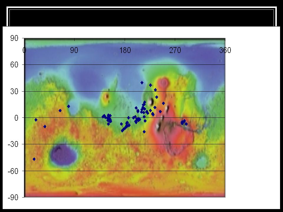
Our paragraph: Most of the points are in the green and near the equator. They are also mostly in between 90 to 180 longitude range and the -30 and 30 latitude range. The points are clustered together.

Similar presentations


 period ( 24 hours for each orbit) Always above same location. Must.>")


