Download presentation
Presentation is loading. Please wait.

1
Canadian Geography 1202

2
Term 1 Term 2 Introduction to Geography Unit 1
Natural and Human Systems Unit 2 Human population Issues Term 2 Unit 3 Economic Issues Unit 4 Global Issues

3
Evaluation Chapter Quizzes / Unit Tests ………………………………20%
Assignments …………………………………………………….….30% Exams ………………………………………………………………….50% Mid-Term Exam ………………………………………………20% Final Exam ……………………………………………………….30%

4
Canada, Geography and You
Introduction Canada, Geography and You

5
Part 1 Canada’s Geographic Character
What is Geography? Geography is the study of how the earth works and how people interact with their earthly home.

6
People around the world often think of Canada as the “Four M’s”
Mountains

7
2. Moose

8
3. Mounties

9
Maples

10
Like most countries, “Canada” is unique (different) in many ways:
People Places Environmental Challenges Social Challenges Economic Challenges Refer to page 2 and 3

11
Key Terms Landscape Place Relative Location Latitude Longitude
Prime Meridian Absolute Location

12
Complete the challenge on page 4 of the text.
Take The Challenge What do you know about Canada??? Complete the challenge on page 4 of the text.

13
The Canadian Cities Quiz

14
Use the clues to determine the name of each city.
Named after a Queen. Victoria 2. Begins like the name of it’s province. Quebec City

15
3. A colorful cutting tool.
Yellowknife 4. A Goose’s Mate. Gander 5. Three Rivers en francais. Trois Rivieres 6. A knight in shining armour rides a ……… Whitehorse

16
Canada’s Places (pg. 5) Symbols represent Canada’s wide variety of landscapes. (page 5, Fig. 1.3)
 .")
17
Landscape refers to : Natural Features
Examples (Mountains, Rivers, Wildlife) Human Features Example (Farmers Fields, Buildings)
 Human Features. Example (Farmers Fields, Buildings)")
18
In-class Activity Page…..
Write the letters of the alphabet on a piece of paper. With a partner brainstorm and quickly jot down words that remind you of Canada that begin with each letter. A class discussion will follow.

19
Canada; A Sense of Place
Place – Is any spot or area on the surface of the earth. (Fig. 1.4)
")
20
Canada’s Place on the Planet
Area Canada is the second largest country in the world. Canada covers an area of 9,971,000 Square Kilometers, while Russia is the largest with 17,075,000 square Kilometers.

21
Canada’s Exceptional Places
Canada is known for it’s exceptional natural environment and their unique human characteristics Example; Canada has 13 UNESCO world heritage sites. Gros Morne National Park is one of those.

22
Finding a Place Two Ways to find a place:
Relative Location – is a description of where something exist in relation to other places. It shows the way that places are connected to other places – by water, land, transportation route, or technology. Example; St. John’s, Newfoundland is the most easterly city in Canada.

23
2. Absolute Location – is the exact location
2. Absolute Location – is the exact location of a place measured by its Latitude and Longitude. Example; Bay Roberts, Newfoundland is º latitude, º longitude. Latitude – Is the distance North or South of the equator measured in degrees; the equator is 0 degrees latitude. The equator means equal. (ie) it is divided into two equal parts (spheres).
 it is divided into two equal parts (spheres).")
25
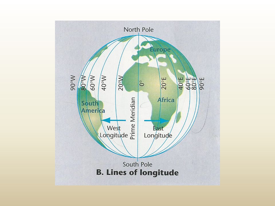
Longitude – Is the distance east and west of the Prime Meridian measured in degrees. Lines of longitude passes through both poles and are used to find locations east and west of the zero degrees longitude or the prime meridian, which passes through Greenwich, England.

27
Grid – Latitude and Longitude lines intersect to make up a set of coordinates to indicate the Absolute location of any point on the earths surface.

28
Note; Latitude and longitude are distance units measured in degrees, minutes and seconds. We write 83º 70´ N Latitude as 83 degrees, 70 minutes North Latitude. ** One degree of Latitude represents about 111 kilometers

29
Location Canada How much land mass does Canada cover? Northern most Settlement Alert on Ellesmere Island 83º 70´ N Latitude Southern most Place Middle Island in Lake Erie 41º 41´ N Latitude

30
Eastern most Place Cape Spear, St. John’s NL. 52º 37´ W Longitude Western most Place Border between the Yukon and the US State of Alaska. 141º 00´ W Longitude

31
If you were to draw an imaginary line from Cape Spear, NL
If you were to draw an imaginary line from Cape Spear, NL. to the Yukon – Alaska border, you would have covered a distance of approximately 5500 kilometers.

32
Using the diagram provided complete the questions..
Give the latitude and longitude for the locations A to E located on the grid. Calculate the number of kilometers Location A and C?

33
Answers; Point A - 40ºN 20ºW Point B - 20ºN 40ºW Point C - 0ºN 20ºW Point D - 20ºS 20ºE Point E - 60ºN 40ºE 2. The distance between A and C is 40º, so 40ºx111km = 4440 Kilometers

34
On the map of Canada indicate the big city that is close to the following coordinates.
A. 50ºN 97ºW Winnipeg B. 49ºN 123ºW ____________ C. 45ºN 66ºW D. 44ºN 79ºW

35
Canada’s Place in Space

36
Earth; The earth is tilted on it’s axis 231/2º The earth rotates on it’s axis once every 24 hours, thus giving us day and night. The Tropic of Cancer is 231/2º N of the equator. The Tropic of Capricorn is 231/2º S of the equator.

Similar presentations