Download presentation
Presentation is loading. Please wait.

1
The Physical Environment of Kaikoura Dr Martin Single Department of Geography University of Canterbury CGTA Kaikoura Workshop2004

2
Setting Geology Relief and Bathymetry Climate Landform Development Dynamic Processes

3
Setting

9
Geology Geology map with comments about ages and Kaikoura Orogeny etc. Faults and rock types

10
Climate Sunshine hours 2068 Temperature 8 to 17C –Frosts do occur Rainfall –865mm/yr at coast –1300+mm/yr in mountains High number of high intensity events - 100 to 150 raindays Seasonal low in summer. Peak rain in Autumn, 100mm in day not uncommon Snow down to 1200m for half the year Cyclone Alison March 1975 155mm in 6 hrs, 193mm in 12 hrs, 205mm in 24 hrs. Record high on May 6 1923 - 345mm in 24 hrs

11
Winds and Waves Wind regime is bi-directional – prevailing from northeast (15.3%) – north to east (28.5%) –southwest (16.7%) - south to west (43.2%) –Calm (27.6%),Nor’west (0.7%) Sea conditions –Mainly from northeast and south – east coast swell –Local waves from northeast –Swell from south Hs<1.0m, T = 12s Hs>1.5m, T = 12 to 14s Calm (0-0.5m) 79.1%; rough (2.5-4.0m) 4.4% Sheltering effect of peninsula (lee from southerlies to Hapuku) –>1.5m 15% South Bay, 3% EPFS Tides 1.1m above Lyttelton datum, Spring range 1.3m, but perigean range can be up to 2.5m
 – north to east (28.5%) –southwest (16.7%) - south to west (43.2%) –Calm (27.6%),Nor’west (0.7%) Sea conditions –Mainly from northeast and south – east coast swell –Local waves from northeast –Swell from south Hs<1.0m, T = 12s Hs>1.5m, T = 12 to 14s Calm (0-0.5m) 79.1%; rough ( m) 4.4% Sheltering effect of peninsula (lee from southerlies to Hapuku) –>1.5m 15% South Bay, 3% EPFS Tides 1.1m above Lyttelton datum, Spring range 1.3m, but perigean range can be up to 2.5m")
12
Bathymetry Bathymetric map Continental shelf – slopes to 100m in 6km offshore of Kowhai R, then to 1000m in next 4km At Hapuku R shelf is 15km wide and 150m deep at margin

13
Kaikoura Canyon Meeting of cool antarctic waters with warmer waters from north – result in highly productive biology. Kaikoura Canyon joins Hikurangi Trough -range of water depths near the coast. Unstable margins contain sites of massive submarine slides which would result in local tsunami

14
Relief Relief map Tectonics Kaikoura Orogeny Uplift 1m/1000yrs 2.3 to 10m over last 1000yrs Erosion - fluvial Deposition - fans/plains Erosion - marine

15
Landform Development McKay 1885 Shulmeister and Kirk 1993

16
The Evolution of the Kaikoura Lagoon as proposed by Dawe (1997). A: The interpretation of Kaikoura as it may have appeared 10,000 years B.P. with a rising sea-level then 30 metres below present. B: Kaikoura 5,500 years B.P with sea levels higher forming cliffs into the outwash plains. The area at this time was tectonically lower than at present.

17
C: 2,500 years B.P. Erosion of the outwash plains providing sediments for the development of the spit, which grew and consequently formed a lagoon on the landward side. From this point in time the coastline began to prograde from a combination of sea level drops and tectonic uplift events. D: The present day coastline. (Adaption of Dawe by Boorer 2002)
.")
18
Dynamic Processes

20
December 25 1993

21
Dynamic Processes December 25 1993

22
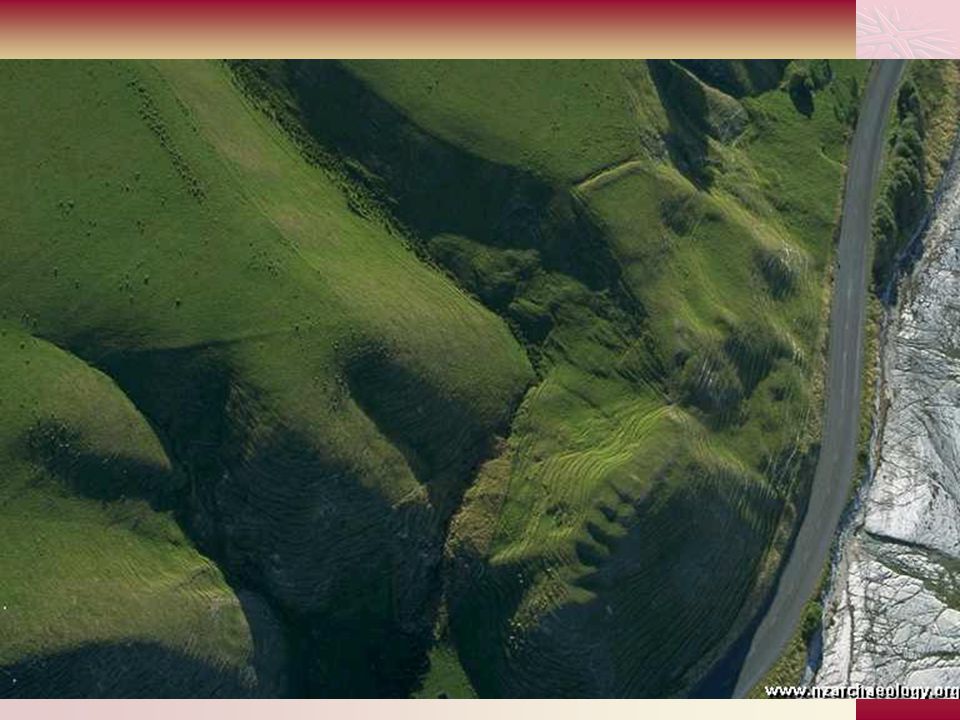
Dynamic Processes Two views of South Bay pa (pre- European), Kaikoura Peninsula. Ditches and banks enclose the points formed by the cliff.

26
Ferae Naturae

Similar presentations


 Undergrad Library (web access) “Sediments”, from “Oceanography”>")


