Download presentation
Presentation is loading. Please wait.

1
Plate Tectonics

2
Layers of the Earth

3
Crust– 1 st layer is solid rock. The thinnest layer. Crust– 1 st layer is solid rock. The thinnest layer. Lithosphere – The layer that is the crust and the top of the mantle. Lithos means “rock”. Lithosphere – The layer that is the crust and the top of the mantle. Lithos means “rock”. Asthenosphere – The layer just below the lithosphere & is part of the upper mantle. Acts like a plastic, with low density. The layer that moves the crustal plates. Asthenosphere – The layer just below the lithosphere & is part of the upper mantle. Acts like a plastic, with low density. The layer that moves the crustal plates. Mantle – Layer of hot solid rock. The thickest layer. Mantle – Layer of hot solid rock. The thickest layer. Outer Core – Layer made of liquid iron and nickel. Is responsible for Earth’s electromagnetic field. Outer Core – Layer made of liquid iron and nickel. Is responsible for Earth’s electromagnetic field. Inner Core – Layer of solid iron and nickel. Inner Core – Layer of solid iron and nickel.

4
Composition of the Layers The Earth becomes denser the farther you go inside. The Earth becomes denser the farther you go inside. The crust is made primarily of silicon and oxygen (silicates) as well as calcium (Ca) & sodium (Na). The crust is made primarily of silicon and oxygen (silicates) as well as calcium (Ca) & sodium (Na). The mantle is primarily iron (Fe), magnesium (Mg), aluminum (Al), silicon (Si), and oxygen (O). The mantle is primarily iron (Fe), magnesium (Mg), aluminum (Al), silicon (Si), and oxygen (O).
 as well as calcium (Ca) & sodium (Na). The crust is made primarily of silicon and oxygen (silicates) as well as calcium (Ca) & sodium (Na). The mantle is primarily iron (Fe), magnesium (Mg), aluminum (Al), silicon (Si), and oxygen (O). The mantle is primarily iron (Fe), magnesium (Mg), aluminum (Al), silicon (Si), and oxygen (O)..")
7
Electromagnetic Field The Electromagnetic (EM) field is caused due to the spinning iron and nickel in the outer core. The Electromagnetic (EM) field is caused due to the spinning iron and nickel in the outer core. The EM field protects Earth from harmful electromagnetic waves in space. The EM field protects Earth from harmful electromagnetic waves in space. The field also gives Earth its magnetism (North & South Pole). The field also gives Earth its magnetism (North & South Pole). The EM field changes each day. It constantly has to be measured all over Earth. The EM field changes each day. It constantly has to be measured all over Earth.
 field is caused due to the spinning iron and nickel in the outer core. The EM field protects Earth from harmful electromagnetic waves in space. The EM field protects Earth from harmful electromagnetic waves in space. The field also gives Earth its magnetism (North & South Pole). The field also gives Earth its magnetism (North & South Pole). The EM field changes each day. It constantly has to be measured all over Earth. The EM field changes each day. It constantly has to be measured all over Earth..")
10
Form from electrons and protons. Held together by the magnetic field.

12
Crust Features There are 2 types of crust – Ocean & Continental. There are 2 types of crust – Ocean & Continental. Ocean crust is most dense and is made mostly of basalt. Rocks tend to be younger (no more than 200 million yrs.) Ocean crust is most dense and is made mostly of basalt. Rocks tend to be younger (no more than 200 million yrs.) Continental crust is less dense and is made mostly of granite. Rocks tend to be the oldest on Earth. Continental crust is less dense and is made mostly of granite. Rocks tend to be the oldest on Earth.
 Ocean crust is most dense and is made mostly of basalt. Rocks tend to be younger (no more than 200 million yrs.) Continental crust is less dense and is made mostly of granite. Rocks tend to be the oldest on Earth. Continental crust is less dense and is made mostly of granite. Rocks tend to be the oldest on Earth..")
13
Plate Tectonics THEORY - The crust is brittle and can break. The crust itself is broken into plates. THEORY - The crust is brittle and can break. The crust itself is broken into plates. These plates move due to convection currents in the asthenosphere. These plates move due to convection currents in the asthenosphere.

14
A boiling pot illustrates the convection current in a liquid. Scientists hypothesize that a similar action is happening in the asthenosphere.

15
The convection current moves the plates slowly over time.

16
Overview of the actions at plate boundaries

17
The Theories….. Various models of how the asthenosphere may be behaving.

18
Effects of Plate Tectonics Earthquakes Earthquakes Volcanoes Volcanoes Mountains Mountains Continental Drift (Pangaea) Continental Drift (Pangaea)
 Continental Drift (Pangaea)")
19
Hot Spots Hawaiian Islands are the perfect example Hawaiian Islands are the perfect example The Pacific plate is slowly moving to the Northwest The Pacific plate is slowly moving to the Northwest Kauai formed first, and as the plate has moved over the hot spot, Oahu, Molokai, Maui, and finally the big island of Hawaii have successively formed Kauai formed first, and as the plate has moved over the hot spot, Oahu, Molokai, Maui, and finally the big island of Hawaii have successively formed Yellowstone is also an example of a hot spot Yellowstone is also an example of a hot spot Hot Spots are huge plumes of magma that come from the deep mantle

20
Proving Plate Tectonics Paleomagnetism Paleomagnetism Ocean Drilling Ocean Drilling Plate Boundary Evidence – including mapping the ocean floor Plate Boundary Evidence – including mapping the ocean floor Earthquake & Volcanic Activity Earthquake & Volcanic Activity SEISMIC WAVES!! SEISMIC WAVES!!

21
Using Seismic Waves These are devices which detect seismic waves. These are devices which detect seismic waves. The plate is placed in front to create the waves. The plate is placed in front to create the waves. The waves give a profile of the land. The waves give a profile of the land. A sledgehammer can be used to generate the seismic waves

22
Paleomagnetism Rocks that align with the current magnetic field have what we call normal polarity Rocks that align with the current magnetic field have what we call normal polarity Rocks that align to the south pole have what we call reverse polarity Rocks that align to the south pole have what we call reverse polarity The ocean floor is said to have a “zebra stripe” magnetic signal The ocean floor is said to have a “zebra stripe” magnetic signal The zebra stripes are not visible to the naked eye, but only to a magnetometer as it is towed behind a ship Ship

23
Paleomagnetism Yes, the magnetic signature of the rocks flip-flops, but the distances between each reversal are the same on either side of the mid- ocean ridge This allows geologists to conclude that sea-floor spreading is equal on either side of a mid ocean ridge Compare these distances here and you find that they are identical AB EE B CC

24
Ocean Drilling The Deep Sea Drilling Project (DSDP) spent from 1968-1983 drilling 1092 sediment and basalt cores in every ocean on earth The Deep Sea Drilling Project (DSDP) spent from 1968-1983 drilling 1092 sediment and basalt cores in every ocean on earth It was found that fossils in the sediments closest to the ridges were younger than fossils found further away It was found that fossils in the sediments closest to the ridges were younger than fossils found further away This cross section of the Atlantic Ocean shows the topography that the DSDP found Sediments near the ridge were found to be younger than the sediments near the continental margins
 spent from drilling 1092 sediment and basalt cores in every ocean on earth The Deep Sea Drilling Project (DSDP) spent from drilling 1092 sediment and basalt cores in every ocean on earth It was found that fossils in the sediments closest to the ridges were younger than fossils found further away It was found that fossils in the sediments closest to the ridges were younger than fossils found further away This cross section of the Atlantic Ocean shows the topography that the DSDP found Sediments near the ridge were found to be younger than the sediments near the continental margins")
25
Ocean Drilling The ocean vessel “GLOMAR CHALLENGER” was the ship that gathered all the data for the Deep Sea Drilling Project The ocean vessel “GLOMAR CHALLENGER” was the ship that gathered all the data for the Deep Sea Drilling Project DSDP has changed into the Ocean Drilling Program (ODP) and continues to help us understand the oceans even to this day DSDP has changed into the Ocean Drilling Program (ODP) and continues to help us understand the oceans even to this day The Glomar Challenger was named after the original oceanic science vessel, Challenger, of the 1800
 and continues to help us understand the oceans even to this day DSDP has changed into the Ocean Drilling Program (ODP) and continues to help us understand the oceans even to this day The Glomar Challenger was named after the original oceanic science vessel, Challenger, of the 1800")
27
Earthquake Patterns Well over 95% of all earthquakes occur along the current plate boundaries Well over 95% of all earthquakes occur along the current plate boundaries The map shows where earthquakes occur on an annual basis The map shows where earthquakes occur on an annual basis Do the patterns match up with anything you’ve seen before? Do the patterns match up with anything you’ve seen before?

28
The red dots represent earthquake activity. What is the relationship with their location and plate boundaries?

29
Types of Boundaries Convergent – boundaries moving towards each other. Convergent – boundaries moving towards each other. Divergent – boundaries moving away from each other. Divergent – boundaries moving away from each other. Transform – boundaries moving side-by- side. Transform – boundaries moving side-by- side.

30
Divergent Boundaries Rio Grande Rift Valley East Pacific Rise Mid Atlantic Ridge East African Rift Valley Red Sea Mid Indian Ridge

32
Evidence of Divergence in North America Rio Grande Gorge – evidence of the North American plate pulling apart.

33
Convergent Boundaries Andes Mountains Japanese Island Arc Appalachian Mountains Himalayan Mountains Cascade Mountains Ural Mountains Philippine Island Arc Aleutian Island Arc

35
Himalayan Mountains – picture from space French Alps

36
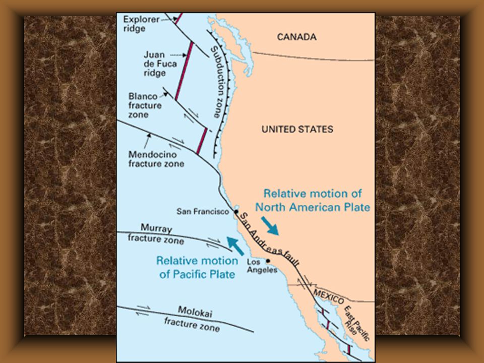
Transform Boundaries San Andreas Fault

38
Continental Drift The theory that Earth’s continents move together and apart due to the moving crustal plates. Developed by Alfred Wegener. The theory that Earth’s continents move together and apart due to the moving crustal plates. Developed by Alfred Wegener. The supercontinent when all 7 are together is called Pangaea. The supercontinent when all 7 are together is called Pangaea. It take approximately 225 million years for the continents to come together. It take approximately 225 million years for the continents to come together.

39
The Evidence Continental Jigsaw Puzzle – shorelines & continental shelves fit together. Continental Jigsaw Puzzle – shorelines & continental shelves fit together. Fossils – fossils of animals and plants matched on different continents that had no way of being transported across an ocean. Fossils – fossils of animals and plants matched on different continents that had no way of being transported across an ocean. Examples – Glossopteris (fern) found in Africa, Asia, Australia, India, Antarctica, & South America; Mesosaurus found in South America & Africa; Marsupials in Australia & North America
 found in Africa, Asia, Australia, India, Antarctica, & South America; Mesosaurus found in South America & Africa; Marsupials in Australia & North America.")
40
Rock Types – Mountain ranges that end at a coastline, then pick up on a different piece of land. Rock Types – Mountain ranges that end at a coastline, then pick up on a different piece of land. Example – Appalachians, Mt. range that starts in the British Isles and then picks up in Scandinavia, Mts. in South America that begin again in Africa. Ancient Climates – Glacial deposits were found in South America & Africa that were identical; Evidence of lush forests in the Northern Hemisphere such as in E. United States, Siberia, & Europe where it is now cold; South Africa was situated over the South Pole. Ancient Climates – Glacial deposits were found in South America & Africa that were identical; Evidence of lush forests in the Northern Hemisphere such as in E. United States, Siberia, & Europe where it is now cold; South Africa was situated over the South Pole.

41
Plates Throughout History

42
Plates Throughout History

48
Plates into the Future

49
Ok, Prove it… REMEMBER: The four main reasons that scientists give to support the theory of plate tectonics REMEMBER: The four main reasons that scientists give to support the theory of plate tectonics –Earthquake Data –Ocean Drilling Data –Hot Spots –Paleomagnetism

Similar presentations


 Mantle Outer Core Inner Core Scientists discovered these.>")


