Download presentation
Presentation is loading. Please wait.

1
U.S. Case Study - June 14, 2005 and Role of the Media Ted Buehner, Warning Coordination Meteorologist National Weather Service Seattle, Washington, USA Ted Buehner, Warning Coordination Meteorologist National Weather Service Seattle, Washington, USA

2
National Weather Service Mission Serving America Since 1870 Provide Weather, Hydrologic, and Climate Forecasts and Warnings for the United States, its Territories, Adjacent Waters and Ocean Areas, for the Protection of Life and Property and Enhancement of the National Economy.

3
The Warning System - Detection / Warning - Dissemination - Response - Detection / Warning - Dissemination - Response

4
To maximize the number of people who take appropriate and timely action to minimize injury, death, and property damage due to hazardous weather and flooding. Warning System Goal:

6
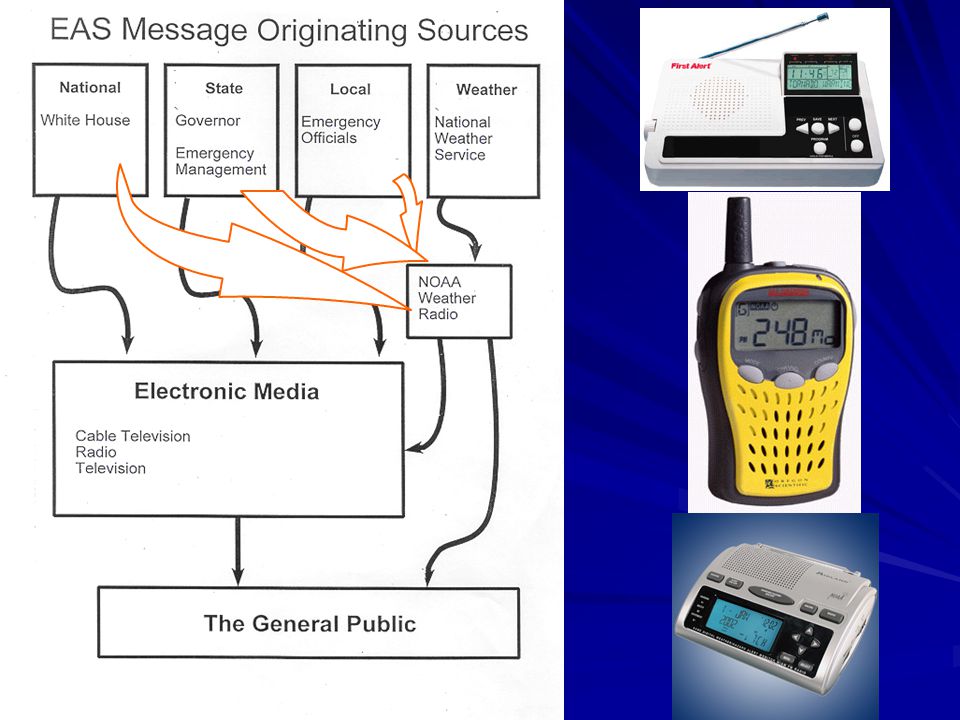
NWR / EAS NWS Warning Product EMWIN NOAA Port Private Vendors Associated Press Media Government Agencies NOAA Weather Wire Internet General Public ACCESS Emergency Mgmt Multiple Paths Multiple Paths

7
NOAA Tsunami “DART” Buoy Tsunami Warning Center – Palmer, Alaska The Tsunami Warning System Weather Radio Receiver

8
The Tsunami Warning System

9
Who Receives EAS Messages via NOAA Weather Radio All Broadcasters All Broadcasters TV TV Radio Radio Cable TV Cable TV Weather Radio Receivers Weather Radio Receivers Homes Homes Businesses Businesses Schools Schools Health Care Facilities Health Care Facilities All-Hazards Alert Broadcast (AHAB) Units All-Hazards Alert Broadcast (AHAB) Units Any With Receivers Any With Receivers All Broadcasters All Broadcasters TV TV Radio Radio Cable TV Cable TV Weather Radio Receivers Weather Radio Receivers Homes Homes Businesses Businesses Schools Schools Health Care Facilities Health Care Facilities All-Hazards Alert Broadcast (AHAB) Units All-Hazards Alert Broadcast (AHAB) Units Any With Receivers Any With Receivers Ocean Shores “AHAB” “AHAB”
 Units All-Hazards Alert Broadcast (AHAB) Units Any With Receivers Any With Receivers All Broadcasters All Broadcasters TV TV Radio Radio Cable TV Cable TV Weather Radio Receivers Weather Radio Receivers Homes Homes Businesses Businesses Schools Schools Health Care Facilities Health Care Facilities All-Hazards Alert Broadcast (AHAB) Units All-Hazards Alert Broadcast (AHAB) Units Any With Receivers Any With Receivers Ocean Shores AHAB AHAB")
10
Emergency Alert System (EAS) Message Elements Header Code Header Code Who – Originator Code Who – Originator Code What – Event Code What – Event Code Where – Location Code Where – Location Code When – Duration Time and Issuance Time When – Duration Time and Issuance Time Who – Station Identification Who – Station Identification Takes About One Second – Repeated 3 Times Takes About One Second – Repeated 3 Times NOAA Weather Radio Warning Alarm NOAA Weather Radio Warning Alarm Voice Message (Up to 2 minutes) Voice Message (Up to 2 minutes) End of Message Tones/Codes End of Message Tones/Codes EAS Tones Are Digital EAS Tones Are Digital Header Code Header Code Who – Originator Code Who – Originator Code What – Event Code What – Event Code Where – Location Code Where – Location Code When – Duration Time and Issuance Time When – Duration Time and Issuance Time Who – Station Identification Who – Station Identification Takes About One Second – Repeated 3 Times Takes About One Second – Repeated 3 Times NOAA Weather Radio Warning Alarm NOAA Weather Radio Warning Alarm Voice Message (Up to 2 minutes) Voice Message (Up to 2 minutes) End of Message Tones/Codes End of Message Tones/Codes EAS Tones Are Digital EAS Tones Are Digital
 Message Elements Header Code Header Code Who – Originator Code Who – Originator Code What – Event Code What – Event Code Where – Location Code Where – Location Code When – Duration Time and Issuance Time When – Duration Time and Issuance Time Who – Station Identification Who – Station Identification Takes About One Second – Repeated 3 Times Takes About One Second – Repeated 3 Times NOAA Weather Radio Warning Alarm NOAA Weather Radio Warning Alarm Voice Message (Up to 2 minutes) Voice Message (Up to 2 minutes) End of Message Tones/Codes End of Message Tones/Codes EAS Tones Are Digital EAS Tones Are Digital Header Code Header Code Who – Originator Code Who – Originator Code What – Event Code What – Event Code Where – Location Code Where – Location Code When – Duration Time and Issuance Time When – Duration Time and Issuance Time Who – Station Identification Who – Station Identification Takes About One Second – Repeated 3 Times Takes About One Second – Repeated 3 Times NOAA Weather Radio Warning Alarm NOAA Weather Radio Warning Alarm Voice Message (Up to 2 minutes) Voice Message (Up to 2 minutes) End of Message Tones/Codes End of Message Tones/Codes EAS Tones Are Digital EAS Tones Are Digital")
11
June 14, 2005 751 PM - 7.4 Magnitude Earthquake about 160 km off the Northern California Coast 756 PM – Tsunami Warning issued by West Coast/Alaska Tsunami Warning Center for Washington, Oregon, California –Within 2 hours travel time 800 PM – No Tsunami Generated Message issued by the Pacific Tsunami Warning Center in Hawaii for rest of Pacific basin beyond the U.S. west coast –Both messages are disseminated to all mediums (media, emergency management, et al) 751 PM - 7.4 Magnitude Earthquake about 160 km off the Northern California Coast 756 PM – Tsunami Warning issued by West Coast/Alaska Tsunami Warning Center for Washington, Oregon, California –Within 2 hours travel time 800 PM – No Tsunami Generated Message issued by the Pacific Tsunami Warning Center in Hawaii for rest of Pacific basin beyond the U.S. west coast –Both messages are disseminated to all mediums (media, emergency management, et al)
 751 PM Magnitude Earthquake about 160 km off the Northern California Coast 756 PM – Tsunami Warning issued by West Coast/Alaska Tsunami Warning Center for Washington, Oregon, California –Within 2 hours travel time 800 PM – No Tsunami Generated Message issued by the Pacific Tsunami Warning Center in Hawaii for rest of Pacific basin beyond the U.S. west coast –Both messages are disseminated to all mediums (media, emergency management, et al).")
12
June 14, 2005 806 PM – NWS Seattle and Portland activated the Emergency Alert System (EAS) via NOAA Weather Radio (four stations serve the coast) –Phone line to two stations on north coast failed EAS not activated on the north coast –Astoria weather radio station signal quality poor EAS message reception was poor on south coast –Not transmitted on western interior stations Seattle and Portland media did not get the EAS message Coastal areas served by Seattle/Portland area TV stations 806 PM – NWS Seattle and Portland activated the Emergency Alert System (EAS) via NOAA Weather Radio (four stations serve the coast) –Phone line to two stations on north coast failed EAS not activated on the north coast –Astoria weather radio station signal quality poor EAS message reception was poor on south coast –Not transmitted on western interior stations Seattle and Portland media did not get the EAS message Coastal areas served by Seattle/Portland area TV stations
 via NOAA Weather Radio (four stations serve the coast) –Phone line to two stations on north coast failed EAS not activated on the north coast –Astoria weather radio station signal quality poor EAS message reception was poor on south coast –Not transmitted on western interior stations Seattle and Portland media did not get the EAS message Coastal areas served by Seattle/Portland area TV stations 806 PM – NWS Seattle and Portland activated the Emergency Alert System (EAS) via NOAA Weather Radio (four stations serve the coast) –Phone line to two stations on north coast failed EAS not activated on the north coast –Astoria weather radio station signal quality poor EAS message reception was poor on south coast –Not transmitted on western interior stations Seattle and Portland media did not get the EAS message Coastal areas served by Seattle/Portland area TV stations")
14
June 14, 2005 811 PM – Clallam County activated its local Emergency Alert System (EAS) for evacuation of low-lying coastal areas via local radio broadcasters –Broadcasters relayed EAS message Quileute and Makah Tribes evacuated Many beach areas evacuated Rest of coastal counties chose to wait and see what happened further south in Oregon and California –EAS not activated for evacuation –Hoh and Quinault Tribes evacuated anyway –Many beach areas had self-evacuation 811 PM – Clallam County activated its local Emergency Alert System (EAS) for evacuation of low-lying coastal areas via local radio broadcasters –Broadcasters relayed EAS message Quileute and Makah Tribes evacuated Many beach areas evacuated Rest of coastal counties chose to wait and see what happened further south in Oregon and California –EAS not activated for evacuation –Hoh and Quinault Tribes evacuated anyway –Many beach areas had self-evacuation
 for evacuation of low-lying coastal areas via local radio broadcasters –Broadcasters relayed EAS message Quileute and Makah Tribes evacuated Many beach areas evacuated Rest of coastal counties chose to wait and see what happened further south in Oregon and California –EAS not activated for evacuation –Hoh and Quinault Tribes evacuated anyway –Many beach areas had self-evacuation 811 PM – Clallam County activated its local Emergency Alert System (EAS) for evacuation of low-lying coastal areas via local radio broadcasters –Broadcasters relayed EAS message Quileute and Makah Tribes evacuated Many beach areas evacuated Rest of coastal counties chose to wait and see what happened further south in Oregon and California –EAS not activated for evacuation –Hoh and Quinault Tribes evacuated anyway –Many beach areas had self-evacuation")
15
June 14, 2005 911 PM (1 hour 20 min after earthquake) - Tsunami Warning cancelled by West Coast/Alaska Tsunami Warning Center for Washington, Oregon, California –Cancellation message disseminated to all mediums (media, emergency management, et al) –No tsunami was generated Quake was horizontal – not vertical Coastal tides gauges showed only a small tsunami 911 PM (1 hour 20 min after earthquake) - Tsunami Warning cancelled by West Coast/Alaska Tsunami Warning Center for Washington, Oregon, California –Cancellation message disseminated to all mediums (media, emergency management, et al) –No tsunami was generated Quake was horizontal – not vertical Coastal tides gauges showed only a small tsunami
 - Tsunami Warning cancelled by West Coast/Alaska Tsunami Warning Center for Washington, Oregon, California –Cancellation message disseminated to all mediums (media, emergency management, et al) –No tsunami was generated Quake was horizontal – not vertical Coastal tides gauges showed only a small tsunami 911 PM (1 hour 20 min after earthquake) - Tsunami Warning cancelled by West Coast/Alaska Tsunami Warning Center for Washington, Oregon, California –Cancellation message disseminated to all mediums (media, emergency management, et al) –No tsunami was generated Quake was horizontal – not vertical Coastal tides gauges showed only a small tsunami")
16
June 14, 2005 Issues Confusion about the tsunami messages –West Coast/Alaska Tsunami Warning Center Tsunami Warning for Washington, Oregon, California Within 2 hours tsunami travel time –Pacific Tsunami Warning Center No Tsunami Expected for rest of Pacific Ocean Basin –Not Enough Updates – Only One Per Hour –Media –Emergency Management Community –General Public Mixed Response to the Warning –Some Evacuated…..Some Did Not Confusion about the tsunami messages –West Coast/Alaska Tsunami Warning Center Tsunami Warning for Washington, Oregon, California Within 2 hours tsunami travel time –Pacific Tsunami Warning Center No Tsunami Expected for rest of Pacific Ocean Basin –Not Enough Updates – Only One Per Hour –Media –Emergency Management Community –General Public Mixed Response to the Warning –Some Evacuated…..Some Did Not

17
June 14, 2005 Issues Confusion about whether to evacuate low- lying coastal areas –Incomplete Information Tsunami Warning in Effect – Yes or No? Wait for Tsunami Confirmation Elsewhere –Washington Emergency Management Stood by to Send a Coastal EAS Evacuation Warning –None Received From Coastal Counties Confusion about whether to evacuate low- lying coastal areas –Incomplete Information Tsunami Warning in Effect – Yes or No? Wait for Tsunami Confirmation Elsewhere –Washington Emergency Management Stood by to Send a Coastal EAS Evacuation Warning –None Received From Coastal Counties

18
June 14, 2005 Issues Tsunami EAS Message Dissemination Problems –Weather Radio Station Communications Phone Line Link Serving Two North Coast Stations Went Down Earlier in the Day Poor Signal Quality for the South Coast Station EAS Message Effectively Aired by only One of Four Weather Radio Stations –Lack of EAS Message Sent to Western Interior Areas Seattle/Portland Broadcasters did not Receive the Tsunami Warning EAS Message Broadcasters did not Air the Tsunami Warning EAS Message –Many Coastal Areas get Seattle/Portland TV/Radio Media Tsunami EAS Message Dissemination Problems –Weather Radio Station Communications Phone Line Link Serving Two North Coast Stations Went Down Earlier in the Day Poor Signal Quality for the South Coast Station EAS Message Effectively Aired by only One of Four Weather Radio Stations –Lack of EAS Message Sent to Western Interior Areas Seattle/Portland Broadcasters did not Receive the Tsunami Warning EAS Message Broadcasters did not Air the Tsunami Warning EAS Message –Many Coastal Areas get Seattle/Portland TV/Radio Media

19
June 14, 2005 Lessons Learned Confusion about the tsunami messages –West Coast/Alaska Tsunami Warning Center –Pacific Tsunami Warning Center Adjusted their statement wording to make them more clear Develop a New Public Warning Message to Reduce Confusion –Not Enough Updates – Only One Per Hour Now have staff for 24/7 operations Update statements every 30 minutes More tsunami detection buoys More coastal tide gauges Confusion about the tsunami messages –West Coast/Alaska Tsunami Warning Center –Pacific Tsunami Warning Center Adjusted their statement wording to make them more clear Develop a New Public Warning Message to Reduce Confusion –Not Enough Updates – Only One Per Hour Now have staff for 24/7 operations Update statements every 30 minutes More tsunami detection buoys More coastal tide gauges

20
June 14, 2005 Lessons Learned Confusion about whether to evacuate low-lying coastal areas –More Tsunami Message Updates More Positive Media and Public Response Includes More Supportive Data –Washington Emergency Management Now have an Agreement with Coastal Counties for One ‘Move to Higher Ground’ EAS Message To Follow Initial Tsunami Warning EAS Message issued by the National Weather Service Coastal Counties can Still Issue their Own Local EAS Evacuation Message Install More All-Hazard Alert Broadcasting (AHAB) Sirens along Coastal Beaches Confusion about whether to evacuate low-lying coastal areas –More Tsunami Message Updates More Positive Media and Public Response Includes More Supportive Data –Washington Emergency Management Now have an Agreement with Coastal Counties for One ‘Move to Higher Ground’ EAS Message To Follow Initial Tsunami Warning EAS Message issued by the National Weather Service Coastal Counties can Still Issue their Own Local EAS Evacuation Message Install More All-Hazard Alert Broadcasting (AHAB) Sirens along Coastal Beaches
 Sirens along Coastal Beaches Confusion about whether to evacuate low-lying coastal areas –More Tsunami Message Updates More Positive Media and Public Response Includes More Supportive Data –Washington Emergency Management Now have an Agreement with Coastal Counties for One ‘Move to Higher Ground’ EAS Message To Follow Initial Tsunami Warning EAS Message issued by the National Weather Service Coastal Counties can Still Issue their Own Local EAS Evacuation Message Install More All-Hazard Alert Broadcasting (AHAB) Sirens along Coastal Beaches")
21
June 14, 2005 Lessons Learned Media –Created a Tsunami Media Kit Joint Effort Between Washington State Emergency Management, National Weather Service and Coastal Counties –Includes Tsunami Fact Sheets Local Subject Matter Experts Local Coastal Area Tsunami Inundation Zone/Evacuation Maps Tsunami Warning System Flow Chart Tsunami Interviews and More Distributed in Person to TV/Radio Broadcasters via a Tsunami Media Tour Plan to Update Kit Each Year Plan to Conduct Tsunami Media Tour Each Year Media –Created a Tsunami Media Kit Joint Effort Between Washington State Emergency Management, National Weather Service and Coastal Counties –Includes Tsunami Fact Sheets Local Subject Matter Experts Local Coastal Area Tsunami Inundation Zone/Evacuation Maps Tsunami Warning System Flow Chart Tsunami Interviews and More Distributed in Person to TV/Radio Broadcasters via a Tsunami Media Tour Plan to Update Kit Each Year Plan to Conduct Tsunami Media Tour Each Year

22
Earthquakes Tsunamis Terrorism Major Chemical Spills Washington Faces Many Non-Weather Hazards

23
NOAA Weather Radio is Washington’s “All-Hazards” Warning System NOAA Weather Radio is Washington’s “All-Hazards” Warning System Ocean Shores “AHAB”

25
NOAA Weather Radio A Life Saver for the Cost of a Pair of Shoes Direct from the NWS 24 hours a day

26
NOAA Weather Radio A Life Saver for the Cost of a Pair of Shoes Latest Area Forecasts and Conditions

27
NOAA Weather Radio A Life Saver for the Cost of a Pair of Shoes Over 900 Stations Across the U.S.

28
NOAA Weather Radio A Life Saver for the Cost of a Pair of Shoes 21 Stations Serve Washington

29
NOAA Weather Radio A Life Saver for the Cost of a Pair of Shoes Has a Warning Alarm Feature

30
NOAA Weather Radio A Life Saver for the Cost of a Pair of Shoes Flood and Weather Warnings as Needed

31
NOAA Weather Radio A Life Saver for the Cost of a Pair of Shoes Key Element in Emergency Alert System (EAS)
")
32
NOAA Weather Radio A Life Saver for the Cost of a Pair of Shoes “All-Hazards” Warning System

33
NOAA Weather Radio A Life Saver for the Cost of a Pair of Shoes Receivers Available at Most Radio Electronic Retailers and via the Internet the Internet

34
NWS Messages to EAS * Tornado Watch or Warning * Severe Thunderstorm Watch or Warning * Flash Flood Watch or Warning * Flood Warning * High Wind Warning * Winter Storm / Heavy Snow / Blizzard Warning * Tsunami Watch or Warning * Civil Emergency Message NWS Messages to EAS * Tornado Watch or Warning * Severe Thunderstorm Watch or Warning * Flash Flood Watch or Warning * Flood Warning * High Wind Warning * Winter Storm / Heavy Snow / Blizzard Warning * Tsunami Watch or Warning * Civil Emergency Message

35
Non -NWS Messages on NOAA Weather Radio Non -NWS Messages on NOAA Weather Radio Examples include: * Civil Emergency Warning * Evacuation Immediate * Shelter in Place Warning * Volcano Warning * Child Abduction Emergency (AMBER) Examples include: * Civil Emergency Warning * Evacuation Immediate * Shelter in Place Warning * Volcano Warning * Child Abduction Emergency (AMBER)
 Examples include: * Civil Emergency Warning * Evacuation Immediate * Shelter in Place Warning * Volcano Warning * Child Abduction Emergency (AMBER)")
36
Not All Weather Radios Receivers Are Alike Key Features To Have –Warning Alarm –SAME (Specific Area Message Encoding) –Event Selection –External Antenna Jack –Others Best Reception Programming Capabilities and Ease Terrain Challenges Key Features To Have –Warning Alarm –SAME (Specific Area Message Encoding) –Event Selection –External Antenna Jack –Others Best Reception Programming Capabilities and Ease Terrain Challenges
 –Event Selection –External Antenna Jack –Others Best Reception Programming Capabilities and Ease Terrain Challenges Key Features To Have –Warning Alarm –SAME (Specific Area Message Encoding) –Event Selection –External Antenna Jack –Others Best Reception Programming Capabilities and Ease Terrain Challenges")
37
StormReady / TsunamiReady Working Together to Save Lives Ocean Shores Long Beach

38
What is Storm/TsunamiReady? A voluntary community preparedness program that promotes weather and tsunami hazard readiness. Primary goal to improve public safety during emergencies. A collaborative effort between federal, state, and local agencies, and the public. A voluntary community preparedness program that promotes weather and tsunami hazard readiness. Primary goal to improve public safety during emergencies. A collaborative effort between federal, state, and local agencies, and the public.

39
TsunamiReady Community Components StormReady Elements –Emergency Operations Center –Multiple Ways to Receive NWS Warnings –Multiple Ways to Disseminate Warnings –Multiple Ways to Monitor Conditions –Hazardous Weather Plan –Community Preparedness Education TsunamiReady Elements –Identify Hazard Zones –Map Evacuation Routes and Assembly Areas –Install Evacuation and Assembly Signage –Educate Community on Tsunami Hazard and Safety Plans StormReady Elements –Emergency Operations Center –Multiple Ways to Receive NWS Warnings –Multiple Ways to Disseminate Warnings –Multiple Ways to Monitor Conditions –Hazardous Weather Plan –Community Preparedness Education TsunamiReady Elements –Identify Hazard Zones –Map Evacuation Routes and Assembly Areas –Install Evacuation and Assembly Signage –Educate Community on Tsunami Hazard and Safety Plans

40
StormReady / TsunamiReady Who -Counties -Communities -Cities -Indian Nations -Supporters - Businesses - Schools How To Apply –Visit www.stormready.noaa.gov and Click on how to apply Recommend Printing out the Word Document for a Worksheet Work with Your Warning Coordination Meteorologist Who -Counties -Communities -Cities -Indian Nations -Supporters - Businesses - Schools How To Apply –Visit www.stormready.noaa.gov and Click on how to apply Recommend Printing out the Word Document for a Worksheet Work with Your Warning Coordination Meteorologist

41
U.S. Case Study - June 14, 2005 and Role of the Media Ted Buehner, Warning Coordination Meteorologist National Weather Service Seattle, Washington, USA Ted Buehner, Warning Coordination Meteorologist National Weather Service Seattle, Washington, USA

42
Questions ??

Similar presentations


 Proposal George Crawford Washington State Emergency Management.>")

 provides for a standardized alerting format for all.>")


 WHO ARE THE PLAYERS? WHAT IS YOUR ROLE?>")


 – Began in 2007 – Currently Transitioning to new Vender.>")


 Louisiana OHSEP Director’s Meeting.>")

