Download presentation
Presentation is loading. Please wait.

1
A Complete Mapping Solution for Directly Georeferenced High Resolution Airborne Imagery.

2
5 cm GSD, 1600 ft AGL, 60 mm VIS lens, Japan

3
20 cm, Madrid, Spain

4
Mining Area, Mount Arthur, Australia

5
30 cm GSD, 8500 ft AGL, 60 mm CIR lens, USA

6
DSS Image from NOAA, Coastal Mapping, Miguel Bay, USA

8
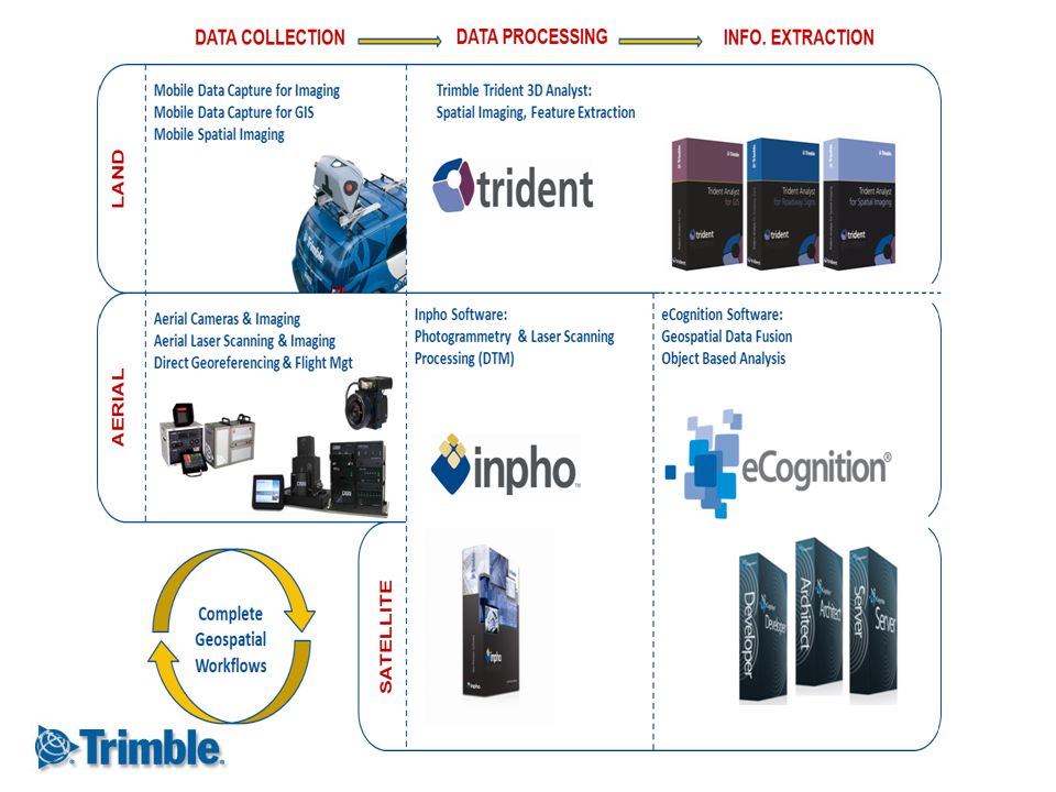
Digital Sensor System. Aerial Mapping Solution.
POS AV GNSS-INS Direct Georeferencing Digital Sensor System. Aerial Mapping Solution. Directly Georeferenced. Turn-Key, Ready-to-Use System. Integrated Trimble Components. Medium-Format, Airborne Digital Camera System. Full-Support, Worldwide, from the Trimble Family. POSTrack Flight Management System Trimble Metric Camera 80, 60, 39 MP Medium-Format, Interchangeable lenses Automatic Azimuth Mount Integrated Electronics Unit, Environmentally Controlled, 500 GB Drive x 2 ? Es el DSS un sistema listo para usar? Si,es una solucion completa. Con el DSS, tenemos - el POS AV para georeferenciacion directa, - POSTrack, un sistema de gestion de vuelo para la planificacion y el funcionamiento. - camara de mediano formato con 60 milimetros, 40 milimetros, o 250 milimetros lentes y 39 mega pixeles. - “Azimuth” mount para corregir el error de “yaw” - Electronica como una unidad de sistema integrado - y software para corregir la solucion de navegacion y para la reproduccion de mapas. INPHO Photogrammetry Image Processing, Information Extraction, and Orthomap Generation

9
NOAA NGS Division uses the DSS for the Coastal Mapping Program.
The Trimble DSS aerial imaging solution was designed to produce orthomaps to increase productivity, achieving a 1:2 or 1:3 ratio of flying time vs. processing time, without compromising accuracy. NOAA NGS Division uses the DSS for the Coastal Mapping Program. DSS VIS image, Japan. Image courtesy of PASCO. DSS CIR image, Stouffville, ON. 3 cm GSD, DSS VIS image, Richmond Hill, ON.

10
Productive Photogrammetric Mapping.
A mission could be flown one day, and the map could be delivered the next day*. The DSS’ direct georeferencing reduces or eliminates the hassle of ground control points and Aerial triangulation. 6 in. GSD. Image courtesy of Cornerstone Mapping. 20 cm GSD, Toronto, ON. 32 cm GSD orthomosaic. Image courtesy of ESRI Collection.

11
Suited for Roads, Highway and Railway Mapping.
DSS Image courtesy of PhotoScience. DSS Image courtesy of Tuck Mapping. DSS Image courtesy of Ohio DOT. 20 cm GSD Orthomosaic, Toronto, ON. The flexibility of interchangeable lenses allow you to capture the corridor swaths (or wide area coverage) that you need for increased productivity.
 that you need for increased productivity.")
12
Rapid Response Applications:
Disaster assessment and management Law enforcement and security surveillance Critical infrastructure mapping Military tactical reconnaissance Insurance mapping Emergency GIS support DSS coastal image in preparation for hurricane emergency response, courtesy of NOAA.

13
The Trimble DSS is currently being used in the combat zones of Iraq and Afghanistan, supplying NATO soldiers with high-accuracy orthomaps. The DSS RapidOrtho produces maps at near real-time (1:1 flying: processing ratio). Soldiers depend on updated map information to plan missions that preserve their lives.
. Soldiers depend on updated map information to plan missions that preserve their lives.")
14
Compact. Flexible. Rapid Deployment.
Image courtesy of Tuck Mapping DSS installed in a Cessna 206.

15
Direct Georeferencing
POS AV GNSS-Aided Inertial Navigation System No Ground Control Points required No Aero-Triangulation required Video Increase Productivity. - Orthophoto production can be completed in hours; not months, not weeks, not days Automated workflow - Reduces the risk of placing personnel in dangerous environments Esta es una gran ventaja porque la reproduccion de mapas y orthofotos es mas rapido. Tambien, ustedes ahorran tiempo, costos y el riesgo de la movilizacion de personal dentro un ambiente peligroso. Applanix suministra los sistemas POS AV y georeferenciacion directa para las camaras de gran formato y para las LIDAR aereas.Y por supuesto, nosotros usamos nuestra propia tecnologia con la camara DSS.

16
Flight Management System Combined FMS and POS AV
Mission Planning Pilot Guidance Airborne Sensor Control Data Archiving Direct Georeferencing Automatic Mount Control

17
Aerial Cameras and Imaging Systems Trimble Aerial Camera (TAC)
Digital, Medium-Format, Metric Camera Purpose-built for Aerial mapping Interchangeable Lenses 39 Megapixel, 6.8 μm (7228 x 5428 pixels) 60 Megapixel, 6.0 μm (8924 x 6732 pixels) 80 Megapixel, 5.2 μm (10328 x 7760 pixels) Lenses Available: DSS 480/460(COLOR ONLY): For Wide-Angle Coverage: 35 mm For Corridor or Orthophoto: 50 mm DSS 439 (VIS AND CIR): 40 mm, 60 mm, 210 mm TAC (Camera Only): 35 mm, 50mm, 60 mm, 72 mm, 100 mm
 60 Megapixel, 6.0 μm (8924 x 6732 pixels) 80 Megapixel, 5.2 μm (10328 x 7760 pixels) Lenses Available: DSS 480/460(COLOR ONLY): For Wide-Angle Coverage: 35 mm. For Corridor or Orthophoto: 50 mm. DSS 439 (VIS AND CIR): 40 mm, 60 mm, 210 mm. TAC (Camera Only): 35 mm, 50mm, 60 mm, 72 mm, 100 mm.")
18
Aerial Cameras and Imaging Systems Wide Area Coverage: Camera Area Footprints

19
Santo Domingo, 30 cm, 60 mm lens, Dominican Republic

20
Hurricane Katrina, 60 mm, New Orleans, USA

21
Canada-USA Border, 60 mm

22
United Nations Refugee Camp, 20 cm, Nairobi, Kenya

23
http://www.trimble.com/geospatial/aerial-mapping.aspx Ernest Yap
Account Manager, Airborne Solutions-Americas Trimble Navigation Ltd., Geospatial Division Richmond Hill Office: 85 Leek Crescent, Richmond Hill, ON Canada

Similar presentations


 – And a good thing!! Massive improvements in software and equipment in.>")


: APPLICATIONS TO ARCHITECTURAL AND LANDSCAPE HERITAGE PRESERVATION – PART 1.>")