Download presentation
Presentation is loading. Please wait.

1
GeoServer and OpenGeo –Chris Holmes

2
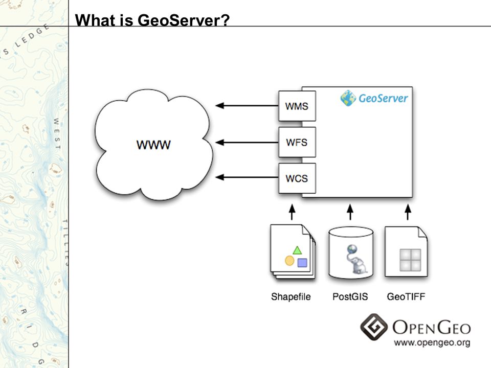
Geospatial Web Server –vector and raster data Open standards –WFS –WMS –WCS Gateway to the “GeoWeb” What is GeoServer?

4
The Past

6
The Present

7
KML

8
REST

9
Rendering

10
ArcSDE

11
Databases

12
Output Formats

13
Extensions

14
2.0

15
489 bug fixes 1682 commits 7 releases * Without October, November, December The Year in Review

16
Bug Fixes

17
Commits

18
Downloads

19
Mailing List Traffic

20
English – 987 members Brazilian – 300 members Chinese – 282 members Italian – 54 members Spanish – 53 members GeoServer International

21
…

22
2.0!

24
New UI

25
Users and roles Data security Service security Security UI

26
Complex feature schemas Feature chaining Application Schemas

27
Super Overlays Geo Search Extrudes Partial 3D KML

28
Labels –curved labeling –repetition –wrapping –displacement Dynamic symbolizers –hatched fills –dynamic glyphs Resource limits Rendering

29
RESTful configuration Styler REST

30
Arbitrary number of bands and pixel depth Color maps Raster catalogs ArcSDE Raster

31
Scalability with sessions Multi-version tables Geometryless JNDI ArcSDE Miscellaneous

32
GDAL support –more formats –robust bindings Mosaics –automated index creation –transparency Coverage rendering Raster Improvements

33
“NG” architecture –security –performance Improved PostGIS and Oracle SQL Server JNDI connections Databases

34
Tiles and pyramids in the database Vector pyramids Charts HTML image maps Extensions

35
Database configuration storage Multi-dimensional coverages Service profiles Web Processing Service Scripting On the Horizon

36
OpenGeo

37
Sorting Confusion

38
In the beginning (The Open Planning Project)
")
39
The first project

40
Towards OpenGeo From a side project of TOPP To sustaining contract work And the push to grow Grow!

41
Building a stack

42
The Client OpenLayers

43
The Cache

44
The Database

45
The Rich Client

46
The OpenGeo Suite

47
Funding

48
Building the Open Geospatial Web Making Geospatial Information Open and Accessible By bringing Open Source Principles to Geo Working by building OS software that gets used by all In the context of a hybrid organization

49
OpenGeo.org

50
Enterprise Towards a Product

51
OpenGe o Suite The full solution

52
Towards the ‘dot-org’ Full Cost Recovery for OpenGeo Spin off like Mozilla Corporation Reinvest profit in similar ‘dot-orgs’ –Make Capital viral like the GPL Require complete transparency Business built on Open Source principles

Similar presentations


 SWIM Application Asia/Pacific AMHS/SWIM Workshop Chaing Mai, Thailand March 5-7, 2012 Tom McParland,>")


 Desktop Web Feature Web Map Server.>")


 24 August 2010.>")

>")


